Texas Lease and Pooling Data Available
In the wacky world of oil and gas data, you never know what unexpected treasures there are to be found. For that matter, you never know what standard data will remain out of reach. Such is the story of the new Texas Lease and Pooling Agreements entry to FracMapper.
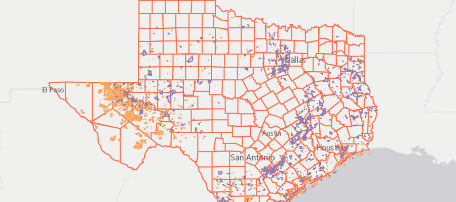
Texas Lease and Pooling Agreements. This map is zoomable and you can click on the map icons for more information. For full access to the FracMapper controls, click the expanding arrows icon in the top right corner.
In many states, even though lease data is technically publicly available, in practice, it is nearly impossible to obtain in a systematic fashion. Imagine searching through stacks of property files at county office buildings to see if there happens to be any mineral rights attached to a plot of land; this is the reason that lease data is so often not available in the way that oil and gas well data usually is. But in Texas, it’s easy: just go the the Texas General Land Office (GLO) website and download it. Not only that, but they have pooling agreement mapping data freely available as well.
On the other hand, the oil and gas well data is not up to the transparency and accessibility standards of other states. Although the agency that regulates that data, the Railroad Commission (RRC) of Texas, has a bevy of search tools available, notably missing from the results are the location data. As it turns out, the Lone Star State actually charges for that data, and a pretty penny too. Luckily, the RRC does provide a one county sample of the sort of data that one might get if they spent thousands of dollars on their data. This has allowed FracTracker to determine that the data purchase is decidedly not worthwhile. The oil and gas wells don’t even have complete well API numbers, let alone spud or permit issue dates.
Hopefully someday, the RRC will follow the data transparency model of the GLO, and not the other way around. A state funded by such a robust severance tax ought to be able to figure out a way to get this data out there for free.
Attn:From MR Moreland I will like to no all about,the oil an gas leases in,Nacogdoches Texas
I have personal knowledge that this map is not accurate. Leases I’ve been involved in for over 30 years don’t even show up here. Honestly this map doesn’t show Oil and Gas Leases that I can tell, and that makes me wonder if the pooling data is accurate as well.
Regarding the RRC charging for data – this data is in high demand and is worth who-knows-how-much to the oil & gas industry. Literally no one knows, because there are definitely untapped or underdeveloped mineral resources hiding in the RRC data. Everyone involved in finding and developing these resources uses RRC data commercially and for profit. Because of the high demand and economic importance of the data, the RRC has to bear considerable cost in providing it and keeping it up to date with current information coming in, and presenting it in a GIS format as well as raw data.
Here’s the other thing – I guarantee that if the oil & gas industry got RRC data and GIS files and well logs and all for free, that would soon be labeled a “tax subsidy” by our haters and wanna-be destroyers. I know it would be, not a doubt in my mind.
It’s really not all that expensive – have you considered something like a Kickstarter crowd-sourcing effort for funding? You guys are doing good things and I bet you could raise the money.
I personally find the data to be worthwhile and useful, but definitely the further back you go the fuzzier it gets.
Thank you for your comments, Chris.
It wouldn’t surprise me if there were errors in the lease or pooling data. Many oil and gas datasets are less than robustly vetted by the agencies that produce them.
As far as purchasing the data, this is something that we could do. However, there are often legal liabilities associated with republishing purchased data. This is the main reason that we have stayed away from doing this in Texas. It probably would be worthwhile if we only wanted the data for internal purposes.
It’s worth noting that of the 21 states that we have mapped so far, Texas is the only one that charges for well locations. North Dakota also charges for some data, but the basic stuff is free.
You’d think that the price of the data could easily be covered by Texas’ robust severance tax.
The National Geothermal Data System (NGDS) under DOE AASG geothermal project in an effort to promote geothermal energy research has released open access data available in ESRI service format as WFS/WMS. Datasets in Excel are also available for download. The data are compatible with similar data for all 50 states in an interoperable data exchange schema. Much of Texas RRC and TBEG well data was provided by the Texas Bureau of Economic Geology, including well headers, borehole temps, well logs, and related resources. This data is available for free to the public through the Geoscience Information Network (USGIN) catalog at central.usgin.org. Data for select Texas wells have been provided (over 300,000 wells). The data was culled from existing well records and logs and has been posted as submitted by the TBEG.
Thank you, Diane. This is valuable information.
Matt