Lakes in Appalachian Ohio’s Utica Play: A Snapshot
By Ted Auch, PhD – Ohio Program Coordinator, FracTracker Alliance
Ohio’s southwest Appalachian counties – namely Carroll, Harrison, Guernsey, and Noble Counties – are home to two significant resources:
- the state’s Utica Shale Triple Play – defined as the extraction of “natural gas and natural gas liquids…from the Marcellus Shale…Upper Devonian Shale…and the Utica Shale about 1,000 to 2,000 feet below the Marcellus” (Range Resources CEO, John Pinkerton); and
- many of the state’s premier lakes, including Atwood in Carroll and Tuscarawas and Senacaville in Noble and Guernsey counties (Figure 1).
Senacaville and Atwood Lakes provide countless ecological and economic benefits (a.k.a., Ecosystem Services) at a regional, state, and local level contributing substantially to the state’s $3.6 billion wildlife tourism economy – a number that is increasing by 2% per year according to the US Fish & Wildlife Service’s Wildlife & Sport Fish Restoration Program (WSFR). Needless to say, the unconventional natural gas industry, which uses approximately 5 million gallons of fresh water per drilled well, relies heavily on Ohio’s lakes, wetlands, and to a lesser degree vernal pools – all of which are concentrated in the Utica Shale sweet spot counties on the Pennsylvania and West Virginia borders. These same counties are home to nearly all the state’s 440+ Utica Wells and more than half its 160+ injection wells (used for waste fluid disposal) (Figure 2).
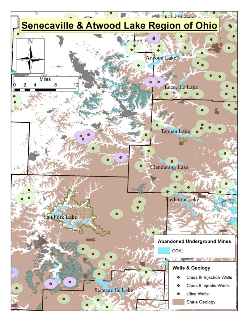
Recently – for these and other environmental reasons – many in the area have grown concerned that Appalachian Ohio’s entire lake network is at risk due to current and proposed hydraulic fracturing and injection wells. In an attempt to assess these risks, we analyzed the proximity of current Utica drilled wells and Class II/III [1] wells to these two lakes specifically and to the state’s inland perennial water bodies. Atwood Lake is the lake with the most wells – either injection or fracturing – within a five-mile radius with 19 total (Figures 3 and 4). Meanwhile, M.J. Kirwan Reservoir, Guilford, and Senacaville Lakes each have 12 wells within a five-mile radius. The Cuyahoga River, Lake Mohawk, Tappan Lake, and Berlin Lake are the remaining water bodies currently within five miles of 10 or more wells. Four of these 19 wells are within two miles of Atwood and Guilford Lake’s shores. In the case of Tappan and Berlin Lakes, 3 wells sit within two miles (Figure 4). Interestingly Tappan Lake’s integrity from a water quality perspective has come under pressure thanks to the Chesapeake Energy Dodson well according to Charles Fisher, administrator of the Harrison County Health Department and organic farmer John M. Luber as “a stream…that empties into Tappan Lake becomes discolored during periods of rainfall or melting snow…the pollution did not happen until drilling operations began.”
In researching previous natural resource activities in the Utica Shale Basin, we found that in addition to the many shale and injection wells in the vicinity of these lakes, most are surrounded or sit atop abandoned, underground coal mines (AUCM). One example is Senacaville Lake, where Seneca Coal’s Klondyke, Rigby, and Walholding AUCMs are within feet of the lake’s western shore. In addition, Akron Coal, James W. Ellsworth, and Cambridge Collieries’ AUCMs just to the west of Senecaville Lake lie directly beneath two Utica and two Class III wells, bringing into question the reported discrete nature of these types of extraction procedures with respect to their proximity to primary freshwater sources. The same is true for Atwood Lake, with six AUCMs less than a mile of its eastern extent – previously owned by the Ohio Central Mining Co., Burns Coal Co., White Barr Coal Co., Marshall Harvey, etc. (Figure 5).
The possibility for the disruption of regular inputs/outputs of these lakes’ hydrological cycles – specifically from a water quality or quantity perspective – is growing. This is the case because the interconnectivity (Setbacks Press Release V 3) between Utica and injection wells is increasing and due to the fact that many AUCM exist in the very areas where hydraulic fracturing is currently being conducted or has been proposed. As a result, many community organizations and non-profit environmental groups are looking to construct and implement a comprehensive water monitoring protocol in Ohio’s Utica Basin. However, given funding limitations and the lack of data being made available from Ohio’s Department of Natural Resource (ODNR) and Ohio Environmental Protection Agency (OEPA), these groups are being forced to prioritize water bodies of concern. Our research suggests that some of the state’s largest and most economically beneficial lakes – namely Senacaville, Atwood, Guilford, Tappan, and Berlin – are at the top of the list of stressed and/or potentially susceptible inland waters.
 Figure 1. Eastern Ohio Utica Shale Basin |
 Figure 2. Ohio lakes, wetlands, & vernal pools relative to Utica Shale & Class II/III injection wells |
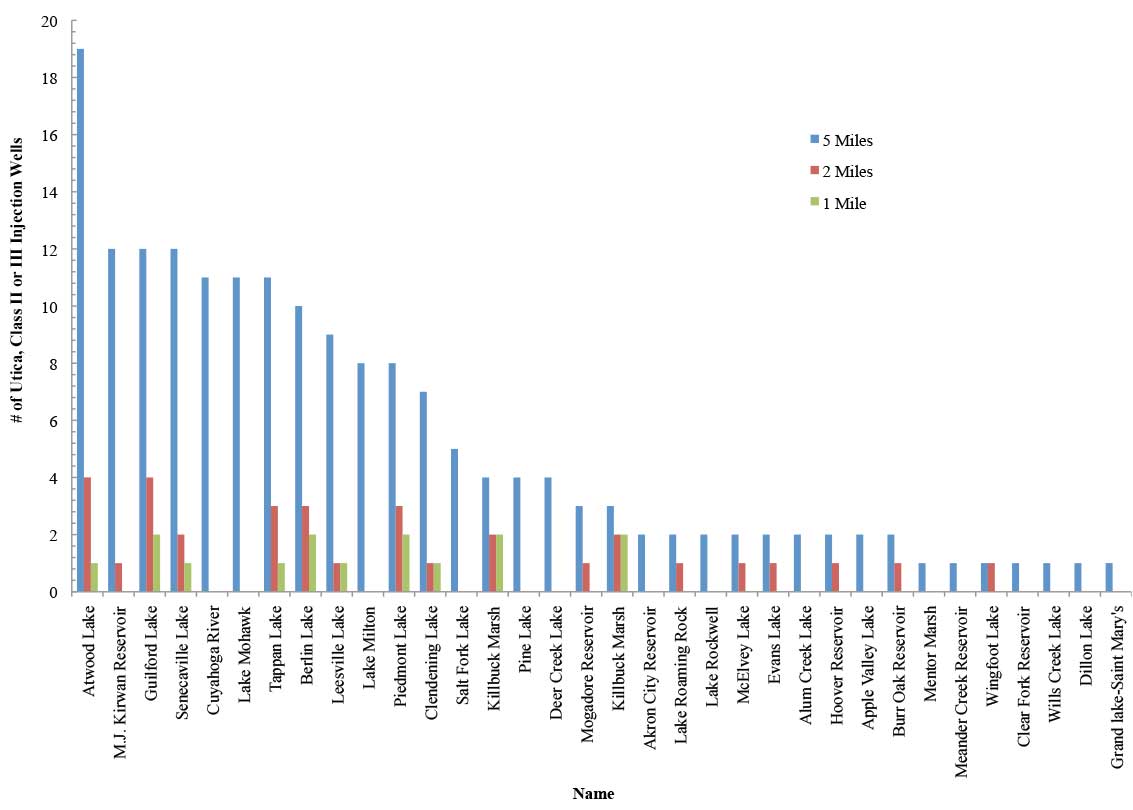 Figure 3. The distribution of Ohio’s Utica Shale and Class II/III Injection wells with respect the region’s primary perennial water bodies at 1, 3, and 5 mile intervals
|
. - Click to enlarge") Figure 4. Senecaville & Atwood Lake Region of Ohio’s shale geology, state parks, Utica Shale & Class II/III wells |
 - Click to enlarge") Figure 5. Senecaville & Atwood Lake Region of Ohio’s shale geology, state parks, Utica Shale & Class II/III wells, plus Abandoned Underground Coal Mines |
Note: Pink & Green Circles in Figures 4 and 5 represent a 1 mile radius around Utica Shale & Class III Wells. |
1. From the ODNR: “Class II disposal wells include conventional brine injection wells, annular disposal wells, and enhanced oil recovery injection wells. Enhanced recovery injection wells are used to increase production of hydrocarbons from nearby producing wells… Additionally, DMRM also regulates Class III salt-solution mining wells, which are used to produce saturated brine from the salt deposits that occur from 2000 to 3500 feet below Ohio’s ground surface. The saturated brine is then used to make table salt, water softener salt, and salt blocks. All types of injection wells are designed to ensure safe injection into permitted formations.”