Western States: Please Abandon the PLSS!
By Matt Kelso, Manager of Data and Technology
Increasingly, the FracTracker Alliance is asked about oil and gas extraction on a national scale. To that end, we are in the process of developing a national dataset of oil and gas wells. Since the data is curated at the state level, it is a challenge to get consistent data formatting from state to state. However, most states at least have the decency to release their location data in decimal degree (DD), that familiar format of latitude and longitude values where users of the data don’t need to calculate the location using three different columns of degrees, minutes, and seconds (DMS).
For example, a DMS point of 45°12’16.4″N, 95°55’12.5″W could be written more tidily in DD as 45.204556, -96.920139. Two numbers, one discrete place on the globe (a random point in rural South Dakota, as it turns out).
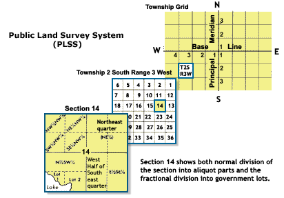
Here is how that same location is properly designated using the Public Land Survey System: “NW 14 T120N R51W Fifth Principal”
Fig. 1 Public Land Survey System. Source: National Atlas
In English, that is the northwest quarter of Section 14, Township 120 North, Range 51 West Fifth Principal. If we wanted to, the quarter section could itself be split into four quarters, and each of those units could be split again, resulting in, for example the SE quarter of the NE quarter of the NW quarter of section 14, Township 120 North, Range 51 West Fifth Principal (See Fig. 1).
To the uninitiated, the PLSS is a needlessly complex system of describing locations in the American West that was devised by Thomas Jefferson to grid out the wild American frontier. As such, it is not altogether surprising that it became the legal definition of place in many western states.
What is surprising is that the system is still in use, at least to the exclusion of other systems. Many states release oil and gas data with multiple geographic systems, including the PLSS, State Plane, UTM, and decimal degrees. This is an acceptable approach, as it caters to cartographers using technology ranging from the eighteenth through twenty-first centuries.
Accuracy Issues
My issue with the PLSS isn’t just that it is annoying. PLSS data are readily available, after all. Differing formats of the various data attributes can be worked out. However, there is inherently an accuracy issue with a system that uses a predefined area to define a point location. If you wanted to use it to describe an area such as a well pad, it is entirely possible that a typical drilling site might straddle four different sections, let alone quarter-quarter-quarter (QQQ) sections. For that matter, well pads could easily span multiple township and range designations, as well.
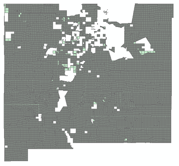
Fig. 2 PLSS sections in New Mexico
Statewide shapefiles that are as detailed as sections are quite large, and are the most detailed data that most data sources offer. This means that the best we can usually do with well data published in PLSS is draw the well at the centroid, or geographical center-point of the section, which in theory is one square mile. Given that the hypotenuse of a square mile block is 1.44 miles, the distance from the centroid to any of the corners is 0.72 miles, or about 3,800 feet, which is the potential error for mapping using PLSS section centroids. While that lack of accuracy is unsatisfying for the FracTracker Alliance, the whole system is a potential nightmare for first responders, in an industry where serious things can go wrong.
In some states, the entire land areas were never even gridded out. New Mexico, for example, has Native American reservations and extensive lands grants that were issued when the region was under Spanish and Mexican control (Fig. 2).
On top of all of that, those square mile sections are not always square. These sections are based on field surveys that were mostly conducted in the 19th century. Walking straight lines in rough terrain isn’t actually all that easy, and in many cases, areas with ferrous deposits in the soil can interfere with the functionality of a magnetic compass. If we take a closer look at the New Mexico sections map (Fig. 3 below), we can see that error is significant.
Moving Forward
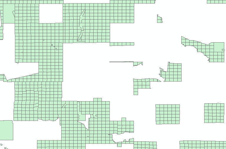
Fig. 3 Areas in green show PLSS Sections in North-Central New Mexico. Areas in white were not gridded out as a part of the survey.
Luckily, we live in an age where technology makes Thomas Jefferson’s valiant attempt at a coordinate system obsolete. Decimal degree is a format that is well understood by GPS devices, Google Maps, sophisticated GIS software, and for the most part, the general public. For mapping purposes, decimal degree is so easy to use and so widely established that other systems, especially the PLSS, come across as needlessly opaque.
This situation is not even analogous with the United States’ famous reluctance to embrace the metric system. It takes some adjustment for people to start thinking in terms of kilograms and meters instead of pounds and feet. PLSS isn’t remotely intuitive as a coordinate system, even among those who use it all the time. It’s time to abandon this as a way of conveying location. I’d like to think that Thomas Jefferson, as a forward-thinking individual, would agree.