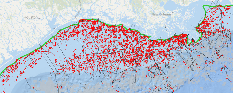
The extent of offshore drilling for oil and gas in the Gulf of Mexico is nothing short of staggering. According to the US National Oceanic and Atmospheric Administration (NOAA), there are more than 3,000 active wells in the federally-regulated waters of the western and central Gulf. Additionally, there are over 25,000 miles of active oil and gas pipelines crisscrossing the Gulf of Mexico sea floor, and more than 18,000 miles of “out of service” pipeline there. To wit, NOAA’s 2012 State of the Coast website boasts, “If placed end to end, the oil and gas pipelines in the Gulf of Mexico could wrap around the Earth’s equator.”
Oil and Gas Infrastructure in the Gulf of Mexico
With such a level of activity, it is difficult to envision how all of this intricate infrastructure fits together, especially in the event of a disaster. There is a dire need to access and visualize such data as more and more wells are drilled unconventionally – both onshore and off. Below is a map of oil and gas drilling platforms both historical and active, pipelines, and active leases in the Gulf of Mexico.
For a full-screen view of this map, with a legend, click here.
The Worst Environmental Incident in US History
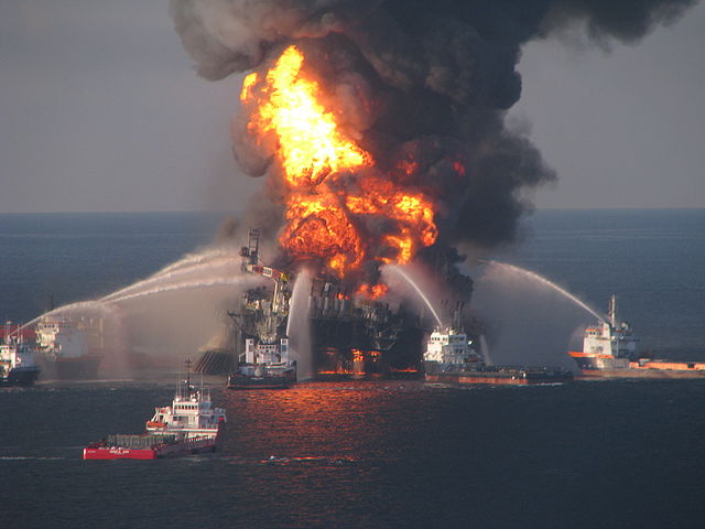
Deepwater Horizon drilling explosion (April 2010)
The April 2010 BP “Deepwater Horizon” blow-out disaster stands out as one of the icons of environmental risks that such intensive oil and gas production can pose to our oceans. The rig was set in over 4,000 feet of water, and close to 6 miles into the sea floor. A blowout occurs when pressurized oil or gas, mud, and water cannot be contained by the well’s blowout preventer. These materials blast through the drill pipe to the surface. There, no longer under pressure, they expand and ignite. Human or mechanical and design errors are at fault the majority of the time. Such was the case with the Macondo Deepwater Horizon disaster, now the worst offshore environmental disaster in US history.
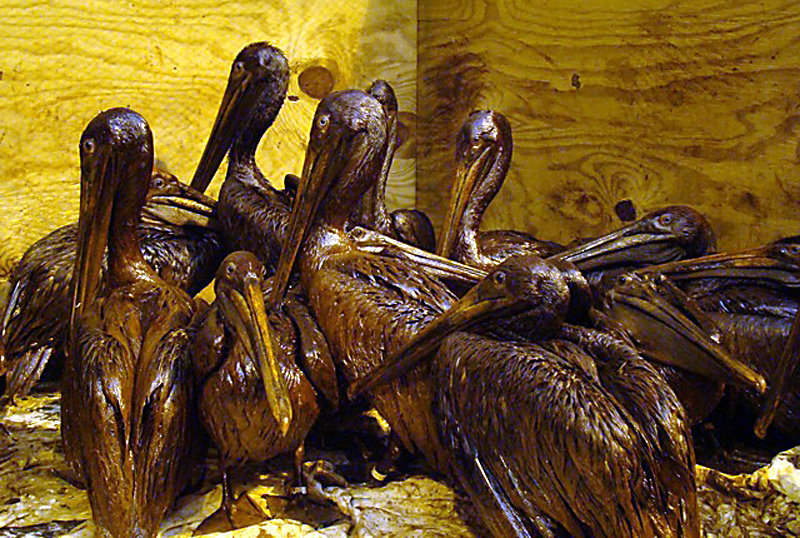
Heavily oiled brown pelicans wait to be cleaned
In all, more than 200 million gallons of oil flowed into the ocean before the Deepwater Horizon well could be plugged. Eleven workers died, and 17 were injured. The Center for Biological Diversity estimates that 82,000 birds, 6000 sea turtles, and nearly 26,000 marine mammals were impacted as a result of this spill.
Penn State University reported actual animal deaths as 6,104 birds, 609 sea turtles, and 100 marine mammals. More than 1,000 miles of shoreline were fouled. Furthermore, as part of the process of breaking up the spill with chemical dispersants, more than 2 million gallons of toxic chemicals were sprayed into the Gulf. The long-term impacts of these dispersants on marine wildlife have yet to be determined.
Other Oil & Gas Exploration Accidents of Note
Natural gas spills also happen with some frequency in the Gulf, but they are considerably different from oil rig blow-outs. Unlike the persistence of oil in the marine environment, gas leaks are dissolved readily into the sea water, and once on the surface, quickly evaporate. Methane-eating bacteria in the water also help in the process. In July 2013, a rig 55 miles offshore, in 154 feet of water in the Gulf off the Louisiana coast, exploded and caught fire. The blaze went out of control and partially destroyed the rig. There was a thin sheen of hydrocarbons on the ocean surface initially, but it dissipated rapidly. A relief well was drilled, and the leak contained. While the effects on marine life may not be tremendous, the release of this amount of carbon to the seawater and atmosphere is yet another stress to global warming, moving us closer by the day to the tipping point of climate disaster.
Unfortunately, these types of leaks and explosions happen with regularity. A maintenance-related explosion happened in September 2011 in the Gulf, 100 miles off the Louisiana coast. All 13 crew on the platform were forced to jump for safety into the water, where they were later rescued. Fortunately, there were no deaths in this case. In September 2014, however, during maintenance at a Chevron natural gas pipeline off the Louisiana coast, one contractor was killed and two injured in another incident.
And Most Recently…
And just last week, on November 20, 2014, there was another report of yet one more Gulf of Mexico oil platform explosion, 12 miles off the coast. This time, one worker was killed and three injured at an explosion at Fieldwood Energy’s Echo Platform. The employees were cleaning a piece of equipment when the blast occurred.
According to news reports, the Bureau of Safety and Environmental Enforcement related, “The Echo Platform was not in production at the time of the incident,” BSEE said in a statement Thursday. “The facility damage was limited to the explosion area and there was no pollution reported.”
Both the September and November incidents are under investigation.
________
GIS datasets for this post originated from the US Bureau of Ocean Energy Management. Learn more
For information on offshore oil and gas exploration in California and the associated danger and regulations, read the October 20, 2013 Fractracker blog entry Hydraulic Fracturing Offshore Wells on the California Coast, by FracTracker’s California staffer Kyle Ferrar.
https://www.fractracker.org/a5ej20sjfwe/wp-content/uploads/2014/11/Pipelines-Feature.png400900Karen Edelsteinhttps://www.fractracker.org/a5ej20sjfwe/wp-content/uploads/2021/04/2021-FracTracker-logo-horizontal.pngKaren Edelstein2014-11-26 15:55:532020-03-12 14:22:31Latest Oil and Gas Incident in the Gulf of Mexico
By Kyle Ferrar, CA Program Coordinator, FracTracker Alliance
As my first year in The Bay Area of California comes to a conclusion and the summer once again turns into fall I realize how much more this time of year meant for me living on the east coast. For us lucky ducks living in the Bay Area, fall is perpetual. With the California drought seasons blur together, but back home in Pennsylvania and New York, fall marks a much appreciated relief from 90°F+ days. Regardless of where you live certain fall activities are universal, including hockey, postseason baseball, football, and most importantly for kids – going back to school.
In California alone, almost 6.24 million students from kindergarten to 12th grade are enrolled and attend classes at one of the 10,366 state “campuses.” State-recognized schools range in size from under a dozen students to a maximum 2013/2014 enrollment of 5,229. When so many children are together in one space, they share much more than just the scholarship, social development, and the occasional but inevitable flu virus. They share the same environmental media (air, water, soil) and are therefore exposed to the same environmental contaminants.
To understand who among this vulnerable population is subject to potential health impacts, the FracTracker Alliance has put together a report analyzing the demographic characteristics of schools located near oil and gas extraction activity. An interactive map of the data that was analyzed is shown below, as are the points of the report. The full report can be found here:
In the background, less than 1,200 feet from the school is
an oil well (API 403043765) that was hydraulically fractured.
Key Findings of School Analysis:
There are 485 active/new oil and gas wells within 1 mile of a school and 177 active/new oil and gas wells within 0.5 miles of a school.
There are 352,784 students who attend school within 1 mile of an oil or gas well, and 121,903 student who attend school within 0.5 miles of an oil or gas well.
There are 78 stimulated wells drilled within 1 mile of a school and 14 stimulated wells drilled within 0.5 miles of a school.
There are 61,612 students who attend school within 1 mile of a stimulated oil or gas well, and 12,362 students who attend school within 0.5 miles of a stimulated oil or gas well.
School Districts with greater Hispanic and non-white student enrollment are more likely to contain more oil and gas drilling and stimulation.
Schools campuses with greater Hispanic and non-white student enrollment are more likely to be closer to more oil and gas drilling and stimulation.
Students attending school within 1 mile of oil and gas wells are predominantly non-white (79.6%), and 60.3% are Hispanic.
The top 11 school districts with the highest well counts are located the San Joaquin Valley with 10 districts in Kern County and the other just north of Kern in Fresno County.
The two districts with the highest well counts are in Kern County; Taft Union High School District, host to 33,155 oil and gas wells, and Kern Union High School District, host to 19,800 oil and gas wells.
Of the schools with the most wells within a 1 mile radius, 8/10 are located in Los Angeles County.
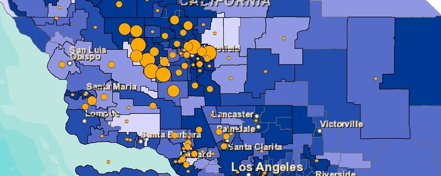
Report Map
The interactive map below allows the user to compare the demographical profiles of school districts with oil and gas drilling and stimulation activity. Non-white enrollment percentages of school districts are displayed in shades of blue. Overlaid with red are the relative counts of stimulated and/or non-stimulated oil and gas wells. The highest counts of wells are hosted in school districts located in the Central (San Joaquin) Valley and along California’s south coast. Geologically, these areas lay above the Monterey Shale – the 50 million year sedimentary basin producing California’s oil reserves.
https://www.fractracker.org/a5ej20sjfwe/wp-content/uploads/2014/11/CA_Schools_WellCts_CoverPhoto.jpg400900Kyle Ferrar, MPHhttps://www.fractracker.org/a5ej20sjfwe/wp-content/uploads/2021/04/2021-FracTracker-logo-horizontal.pngKyle Ferrar, MPH2014-11-17 23:17:432020-07-21 10:34:08Hydraulic fracturing, stimulations, & oil & gas drilling unjustly burden Hispanic & non-white students
By Brook Lenker, Executive Director, FracTracker Alliance
We came to make a stand. People of every age from every corner of the country amassed in New York City on September 21, 2014 – 400,000 people transported by hope. It may have been the autumnal equinox, but the event was a solstice of human expression and determination.
Down Central Park West, across 59th Street, south on Avenue of the Americas, onward to Times Square. Like the circuitous path of the people’s climate march, lawmakers and society at large have meandered around our fossil fuel dependency for too long but take notice: the era of wasting time and wasting away the planet is over.
You could see it in the eyes of college students, parents, grandparents, and children, and I could see it in my daughter, an unfrackable resolve, stronger than any geology. A man remarked that he hadn’t seen so many young people mobilized since the Vietnam War. It will take the involvement of many, many more to move institutions and the public beyond the status quo – to adopt better technologies, modify lifestyles, and accept wholesale conservation.
Images from the March. Photos by Savanna Lenker
I believe we’ve reached a tipping point with the atmosphere and mankind. The former may be hemorrhaging, getting worse before any sign of recuperation – and that’s downright frightening (from rampaging weather to rising seas, life on earth is in for a helluva ride). But the latter has found a partial cure: intergenerational power lifting and embracing renewable energy and lighter ways for civilization.
Change starts with humility and introspection and gains with peer support. In the one-day, peaceful occupation of midtown Manhattan, warm hearts of spectators and a world in solidarity pushed us ahead. Feel the inertia. Join the ride. Because going forward, nothing will be the same.
OH Utica Production, Water Usage, and Waste Disposal by County Part II of a Multi-part Series
By Ted Auch, Great Lakes Program Coordinator, FracTracker Alliance
In this part of our ongoing “Water-Energy Nexus” series focusing on Water and Water Use, we are looking at how counties in Ohio differ between how much oil and gas are produced, as well as the amount of water used and waste produced. This analysis also highlights how the OH DNR’s initial Utica projections differ dramatically from the current state of affairs. In the first article in this series, we conducted an analysis of OH’s water-energy nexus showing that Utica wells are using an ave. of 5 million gallons/well. As lateral well lengths increase, so does water use. In this analysis we demonstrate that:
Drillers have to use more water, at higher pressures, to extract the same unit of oil or gas that they did years ago,
Where production is relatively high, water usage is lower,
As fracking operations move to the perimeter of a marginally productive play – and smaller LLCs and MLPs become a larger component of the landscape – operators are finding minimal returns on $6-8 million in well pad development costs,
Market forces and Muskingum Watershed Conservancy District (MWCD) policy has allowed industry to exploit OH’s freshwater resources at bargain basement prices relative to commonly agreed upon water pricing schemes.
At current prices1, the shale gas industry is allocating < 0.27% of total well pad costs to current – and growing – freshwater requirements. It stands to reason that this multi-part series could be a jumping off point for a more holistic discussion of how we price our “endless” freshwater resources here in OH.
In an effort to better understand the inter-county differences in water usage, waste production, and hydrocarbon productivity across OH’s 19 Utica Shale counties we compiled a data-set for 500+ Utica wells which was previously used to look at differenced in these metrics across the state’s primary industry players. The results from Table 1 below are discussed in detail in the subsequent sections.
Table 1. Hydrocarbon production totals and per day values with top three producers in bold
County
# Wells
Total
Per Day
Oil
Gas
Brine
Production
Days
Oil
Gas
Brine
Ashland
1
0
0
23,598
102
0
0
231
Belmont
32
55,017
39,564,446
450,134
4,667
20
8,578
125
Carroll
256
3,715,771
121,812,758
2,432,022
66,935
67
2,092
58
Columbiana
26
165,316
9,759,353
189,140
6,093
20
2,178
65
Coshocton
1
949
0
23,953
66
14
0
363
Guernsey
29
726,149
7,495,066
275,617
7,060
147
1,413
49
Harrison
74
2,200,863
31,256,851
1,082,239
17,335
136
1,840
118
Jefferson
14
8,396
9,102,302
79,428
2,819
2
2,447
147
Knox
1
0
0
9,078
44
0
0
206
Mahoning
3
2,562
0
4,124
287
9
0
14
Medina
1
0
0
20,217
75
0
0
270
Monroe
12
28,683
13,077,480
165,424
2,045
22
7,348
130
Muskingum
1
18,298
89,689
14,073
455
40
197
31
Noble
39
1,326,326
18,251,742
390,791
7,731
268
3,379
267
Portage
2
2,369
75,749
10,442
245
19
168
228
Stark
1
17,271
166,592
14,285
602
29
277
24
Trumbull
8
48,802
742,164
127,222
1,320
36
566
100
Tuscarawas
1
9,219
77,234
2,117
369
25
209
6
Washington
3
18,976
372,885
67,768
368
59
1,268
192
Production
Total
It will come as no surprise to the reader that OH’s Utica oil and gas production is being led by Carroll County, followed distantly by Harrison, Noble, Belmont, Guernsey and Columbiana counties. Carroll has produced 3.7 million barrels of oil to date, while the latter have combined to produce an additional 4.5 million barrels. Carroll wells have been in production for nearly 67,000 days2, while the aforementioned county wells have been producing for 42,886 days. The remaining counties are home to 49 wells that have been in production for nearly 8,800 days or 7% of total production days in Ohio.
Combined with the state’s remaining 49 producing wells spread across 13 counties, OH’s Utica Shale has produced 8.3 million barrels of oil as well as 251,844,311 Mcf3 of natural gas and 5.4 million barrels of brine. Oil and natural gas together have an estimated value of $2.99 billion ($213 million per quarter)4 assuming average oil and natural gas prices of $96 per barrel and $8.67 per Mcf during the current period of production (2011 to Q2-2014), respectively.
Potential Revenue at Different Severance Tax Rates:
Current production tax, 0.5-0.8%: $19 million ($1.4 Million Per Quarter (MPQ). At this rate it would take the oil and gas industry 35 years to generate the $4.6 billion in tax revenue they proposed would be generated by 2020.
Proposed, 1% gas and 4% oil: At Governor Kasich’s proposed tax rate, $2.99 billion translates into $54 million ($3.9 MPQ). It would still take 21 years to return the aforementioned $4.6 billion to the state’s coffers.
The bottom-line is that a production tax of 11-25% or more ($24-53 MPQ) would be necessary to generate the kind of tax revenue proposed by the end of 2020. This type of O&G taxation regime is employed in the states of Alaska and Oklahoma.
From an outreach and monitoring perspective, effects on air and water quality are two of the biggest gaps in our understanding of shale gas from a socioeconomic, health, and environmental perspective. Pulling out a mere 1% from any of these tax regimes would generate what we’ll call an “Environmental Monitoring Fee.” Available monitoring funds would range between $194,261 and $1.8 million ($16 million at 55%). These monies would be used to purchase 2-21 mobile air quality devices and 10-97 stream quantity/quality gauges to be deployed throughout the state’s primary shale counties to fill in the aforementioned data gaps.
Per-Day Production
On a per-day oil production basis, Belmont and Columbiana (20 barrels per day (BPD)) are overshadowed by Washington (59 BPD) and Muskingum (40 BPD) counties’ four giant Utica wells. Carroll is able to maintain such a high level of production relative to the other 15 counties by shear volume of producing wells; Noble (268 BPD), Guernsey (147 BPD), and Harrison (136 BPD) counties exceed Carroll’s production on a per-day basis. The bottom of the league table includes three oil-free wells in Ashland, Knox, and Medina, as well as seventeen <10 BPD wells in Jefferson and Mahoning counties.
With respect to natural gas, Harrison (1,840 Mcf per day (MPD)) and Guernsey counties are replaced by Monroe (7,348 MPD) and Jefferson (2,447 MPD) counties’ 26 Utica wells. The range of production rates for natural gas is represented by the king of natural gas producers, Belmont County, producing 8,578 MPD on the high end and Mahoning and Coshocton counties in addition to the aforementioned oil dry counties on the low end. Four of the five oil- or gas-dry counties produce the least amount of brine each day (BrPD). Coshocton, Medina, and Noble county Utica wells are currently generating 267-363 barrels of BrPD, with an additional seven counties generating 100-200 BrPD. Only four counties – 1.2% of OH Utica wells – are home to unconventional wells that generate ≤ 30 BrPD.
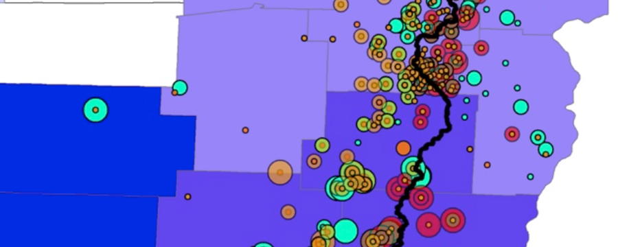
Water Usage
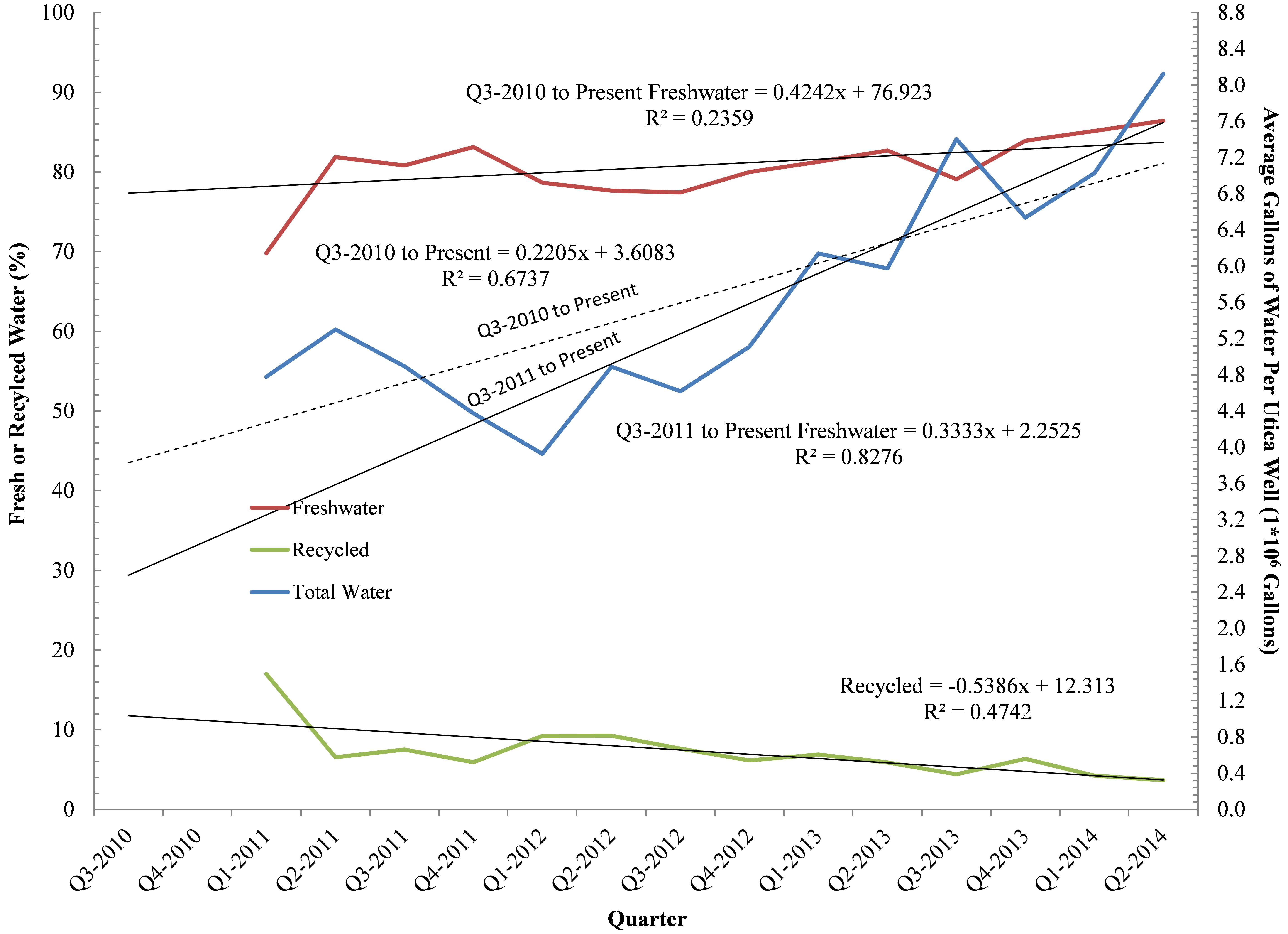
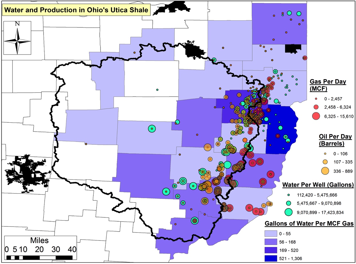
Freshwater is needed for the hydraulic fracturing process during well stimulation. For counties where we had compiled a respectable sample size we found that Monroe and Noble counties are home to the Utica wells requiring the greatest amount of freshwater to obtain acceptable levels of productivity (Figure 1). Monroe and Noble wells are using 10.6 and 8.8 million gallons (MGs) of water per well. Coshocton is home to a well that required 10.8 MGs, while Muskingum and Washington counties are home to wells that have utilized 10.2 and 9.5 MGs, respectively. Belmont, Guernsey, and Harrison reflect the current average state of freshwater usage by the Utica Shale industry in OH, with average requirements of 6.4, 6.9, and 7.2 MGs per well. Wells in eight other counties have used an average of 3.8 (Mahoning) to 5.4 MGs (Tuscarawas). The counties of Ashland, Knox, and Medina are home to wells requiring the least amount of freshwater in the range of 2.2-2.9 MGs. Overall freshwater demand on a per well basis is increasing by 220,500-333,300 gallons per quarter in Ohio with percent recycled water actually declining by 00.54% from an already trivial average of 6-7% in 2011 (Figure 2).
Figure 1. Average water usage (gallons) per Utica well by county
Figure 2. Average water usage (gallons) on per well basis by OH Utica Shale industry, shown quarterly between Q3-2010 & Q2-2014.
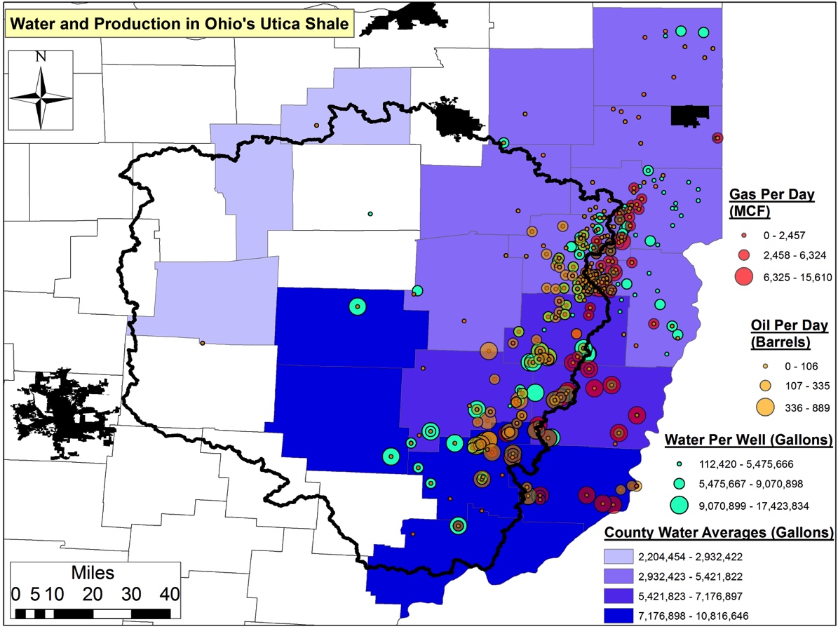
Belmont County’s 30+ Utica wells are the least efficient with respect to oil recovery relative to freshwater requirements, averaging 7,190 gallons of water per gallon of oil (Figure 3). A distant second is Jefferson County’s 14 wells, which have required on average 3,205 gallons of water per gallon of oil. Columbiana’s 26 Utica wells are in third place requiring 1,093 gallons of freshwater. Coshocton, Mahoning, Monroe, and Portage counties are home to wells requiring 146-473 gallons for each gallon of oil produced.
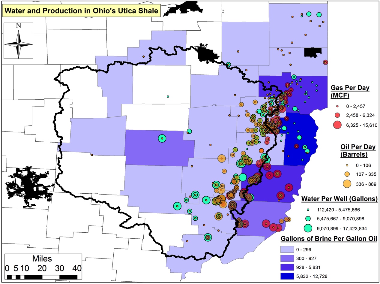
Belmont County’s 14 Utica wells are the least efficient with respect to natural gas recovery relative to freshwater requirements (Figure 4). They average 1,306 gallons of water per Mcf. A distant second is Carroll County’s 250+ wells, which have injected 520 gallons of water 7,000+ feet below the earth’s service to produce a single Mcf of natural gas. Muskingum’s Utica well and Noble County’s 39 wells are the only other wells requiring more than 100 gallons of freshwater per Mcf. The remaining nine counties’ wells require 15-92 gallons of water to produce an Mcf of natural gas.
Figure 3. Average water usage (gallons) per unit of oil (gallons) produced across 19 Ohio Utica counties
Figure 4. Average water usage (gallons) per unit of gas produced (Mcf) across 19 Ohio Utica counties
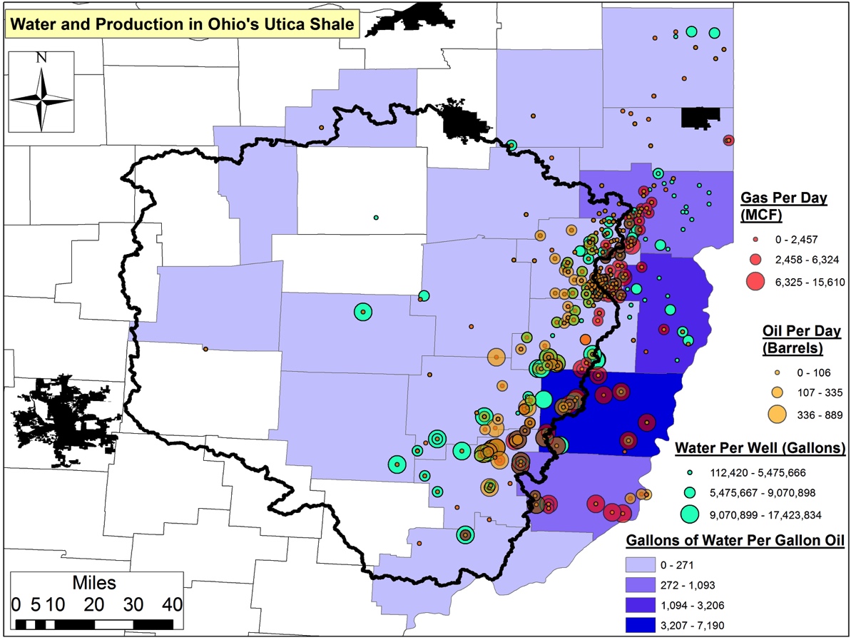
Waste Production
The aforementioned Jefferson wells are the least efficient with respect to waste vs. product produced. Jefferson wells are generating 12,728 gallons of brine per gallon of oil (Figure 5).6 Wells from this county are followed distantly by the 32 Belmont and 26 Columbiana county wells, which are generating 5,830 and 3,976 gallons of brine per unit of oil.5 The remaining counties (for which we have data) are using 8-927 gallons of brine per unit of oil; six counties’ wells are generating <38 gallons of brine per gallon of oil.
Figure 5. Average brine production (gallons) per gallon of oil produced per day across 19 Ohio Utica Counties
The average Utica well in OH is generating 820 gallons of fracking waste per unit of product produced. Across all OH Utica wells, an average of 0.078 gallons of brine is being generated for every gallon of freshwater used. This figure amounts to a current total of 233.9 MGs of brine waste produce statewide. Over the next five years this trend will result in the generation of one billion gallons (BGs) of brine waste and 12.8 BGs of freshwater required in OH. Put another way…
233.9 MGs is equivalent to the annual waste production of 5.2 million Ohioans – or 45% of the state’s current population.
Due to the low costs incurred by industry when they choose to dispose of their fracking waste in OH, drillers will have only to incur $100 million over the next five years to pay for the injection of the above 1.0 BGs of brine. Ohioans, however, will pay at least $1.5 billion in the same time period to dispose of their municipal solid waste. The average fee to dispose of every ton of waste is $32, which means that the $100 million figure is at the very least $33.5 million – and as much as $250.6 million – less than we should expect industry should be paying to offset the costs.
Environmental Accounting
In summary, there are two ways to look at the potential “energy revolution” that is shale gas:
Using the same traditional supply-side economics metrics we have used in the past (e.g., globalization, Efficient Market Hypothesis, Trickle Down Economics, Bubbles Don’t Exist) to socialize long-term externalities and privatize short-term windfall profits, or
We can begin to incorporate into the national dialogue issues pertaining to watershed resilience, ecosystem services, and the more nuanced valuation of our ecosystems via Ecological Economics.
The latter will require a more real-time and granular understanding of water resource utilization and fracking waste production at the watershed and regional scale, especially as it relates to headline production and the often-trumpeted job generating numbers.
We hope to shed further light on this new “environmental accounting” as it relates to more thorough and responsible energy development policy at the state, federal, and global levels. The life cycle costs of shale gas drilling have all too often been ignored and can’t be if we are to generate the types of energy our country demands while also stewarding our ecosystems. As Mark Twain is reported to have said “Whiskey is for drinking; water is for fighting over.” In order to avoid such a battle over the water-energy nexus in the long run it is imperative that we price in the shale gas industry’s water-use footprint in the near term. As we have demonstrated so far with this series this issue is far from settled here in OH and as they say so goes Ohio so goes the nation!
A Moving Target
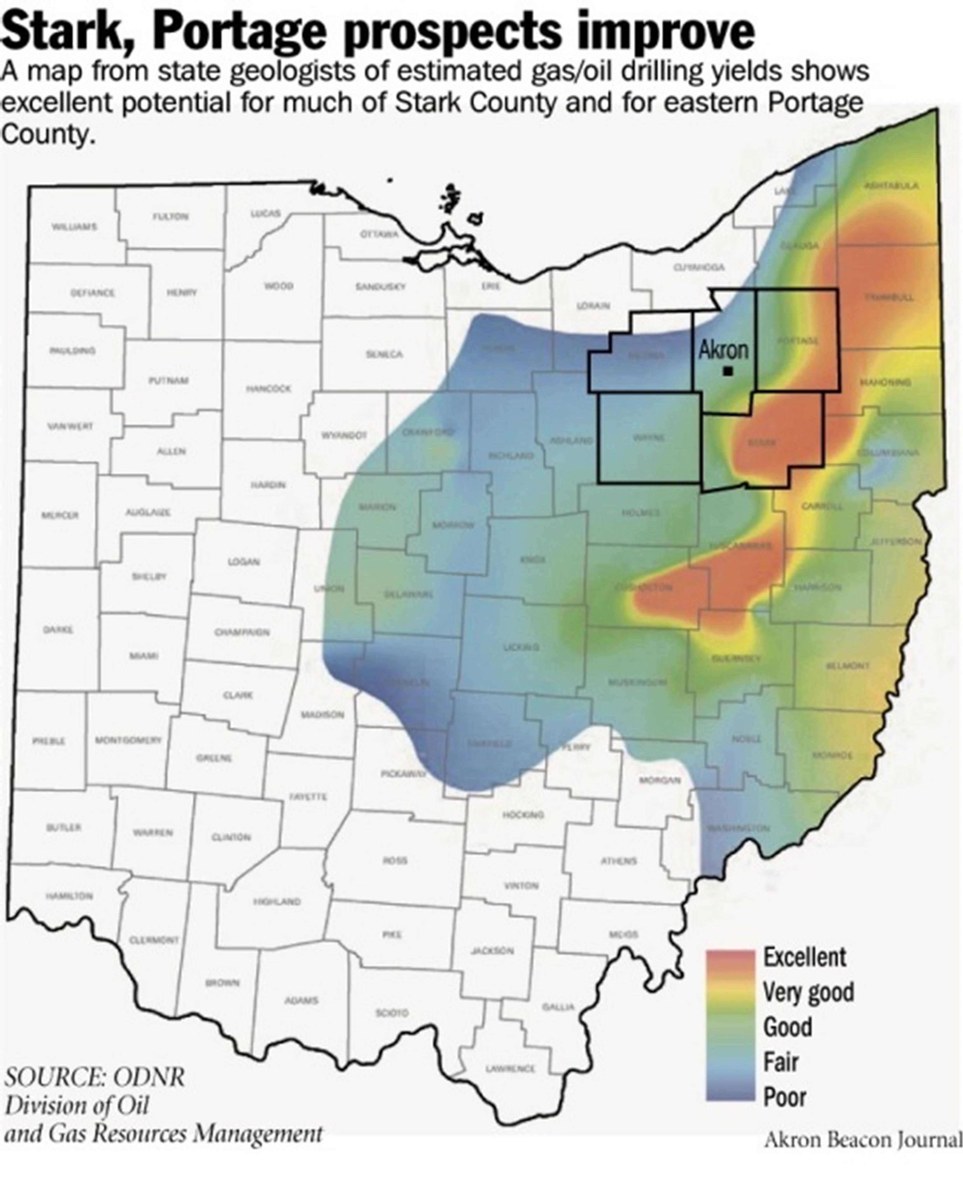
Figure 6. ODNR projection map of potential Utica productivity from spring 2012
OH’s Department of Natural Resources (ODNR) originally claimed a big red – and nearly continuous – blob of Utica productivity existed. The projection originally stretched from Ashtabula and Trumbull counties south-southwest to Tuscarawas, Guernsey, and Coshocton along the Appalachian Plateau (See Figure 6).
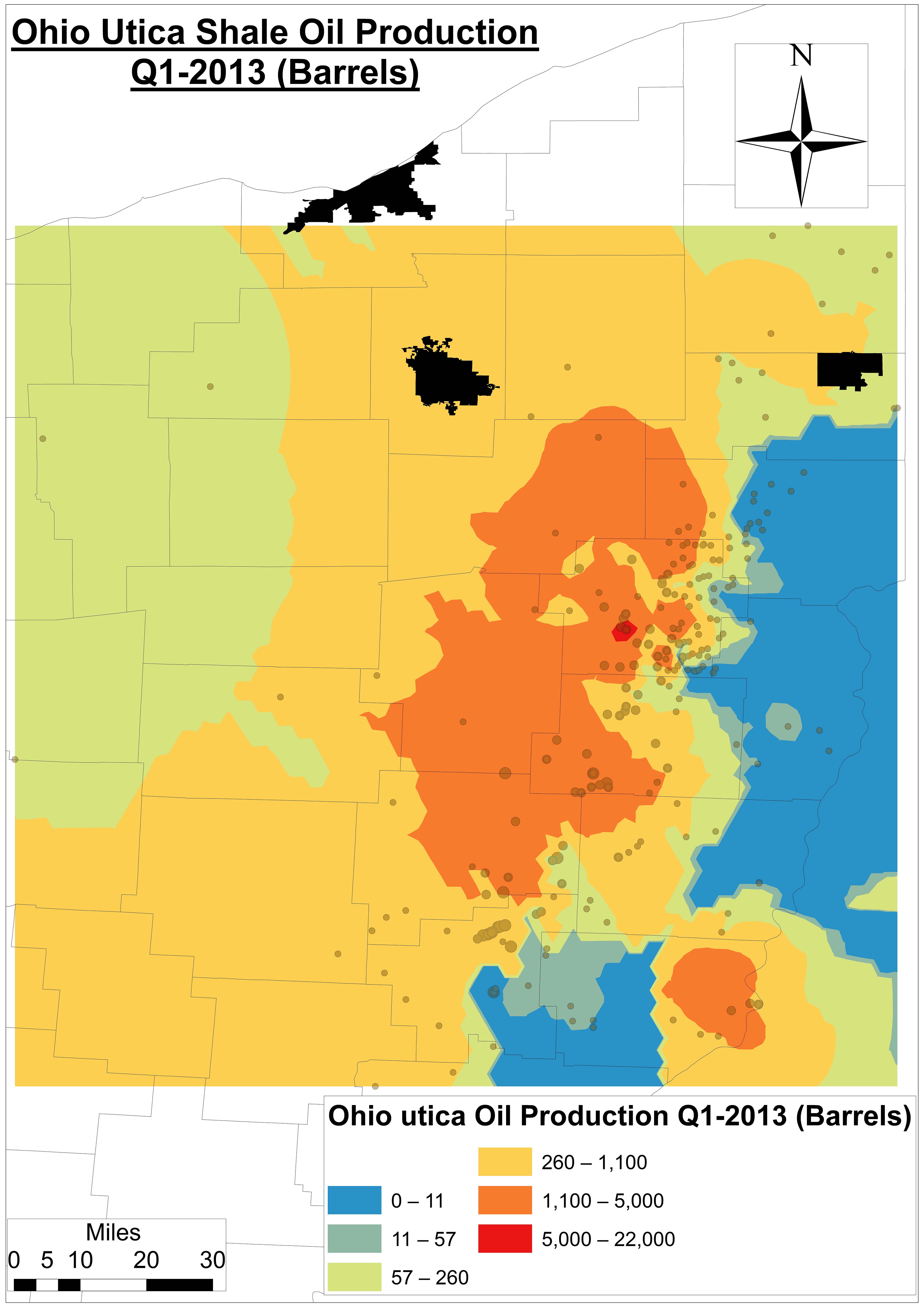
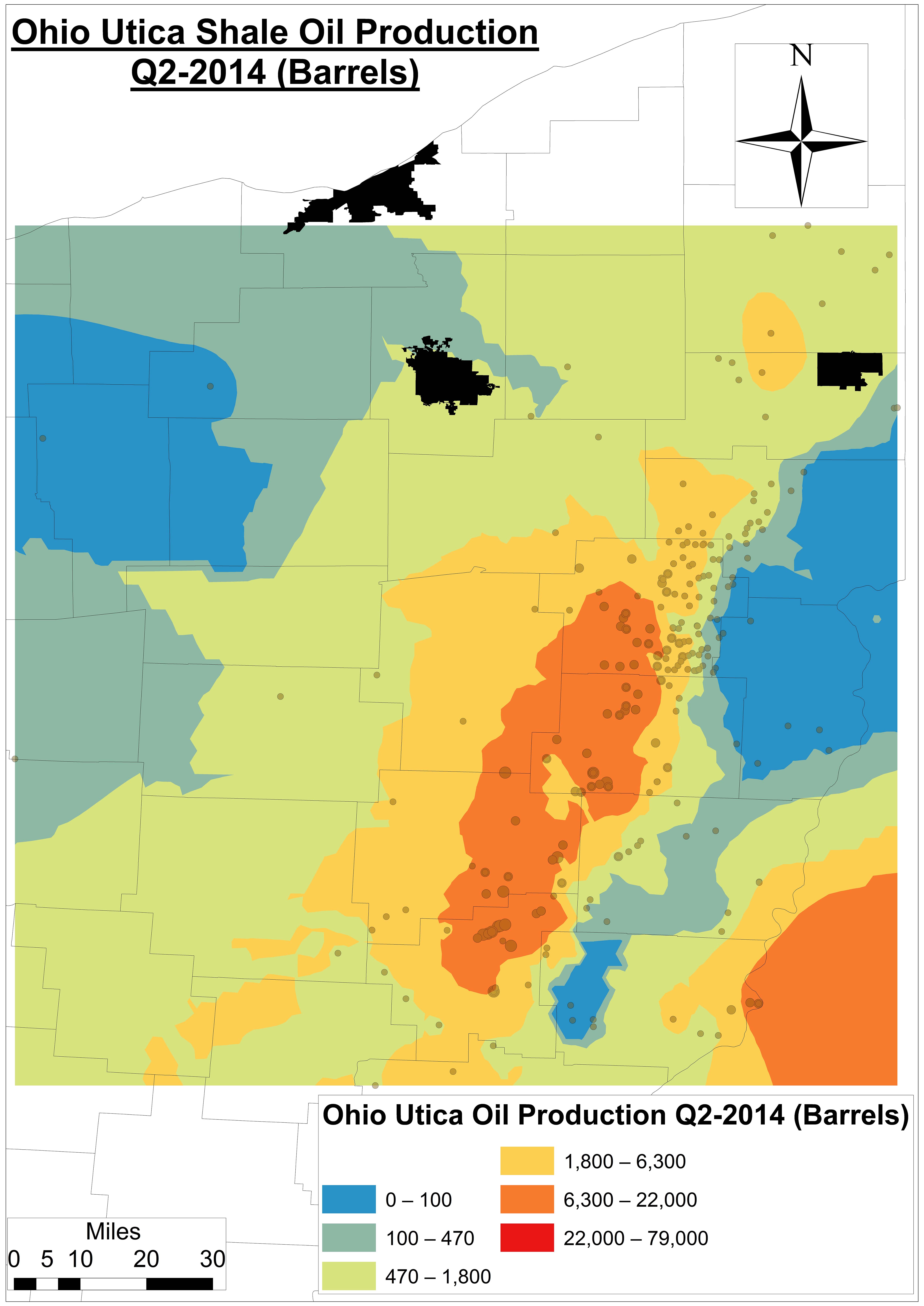
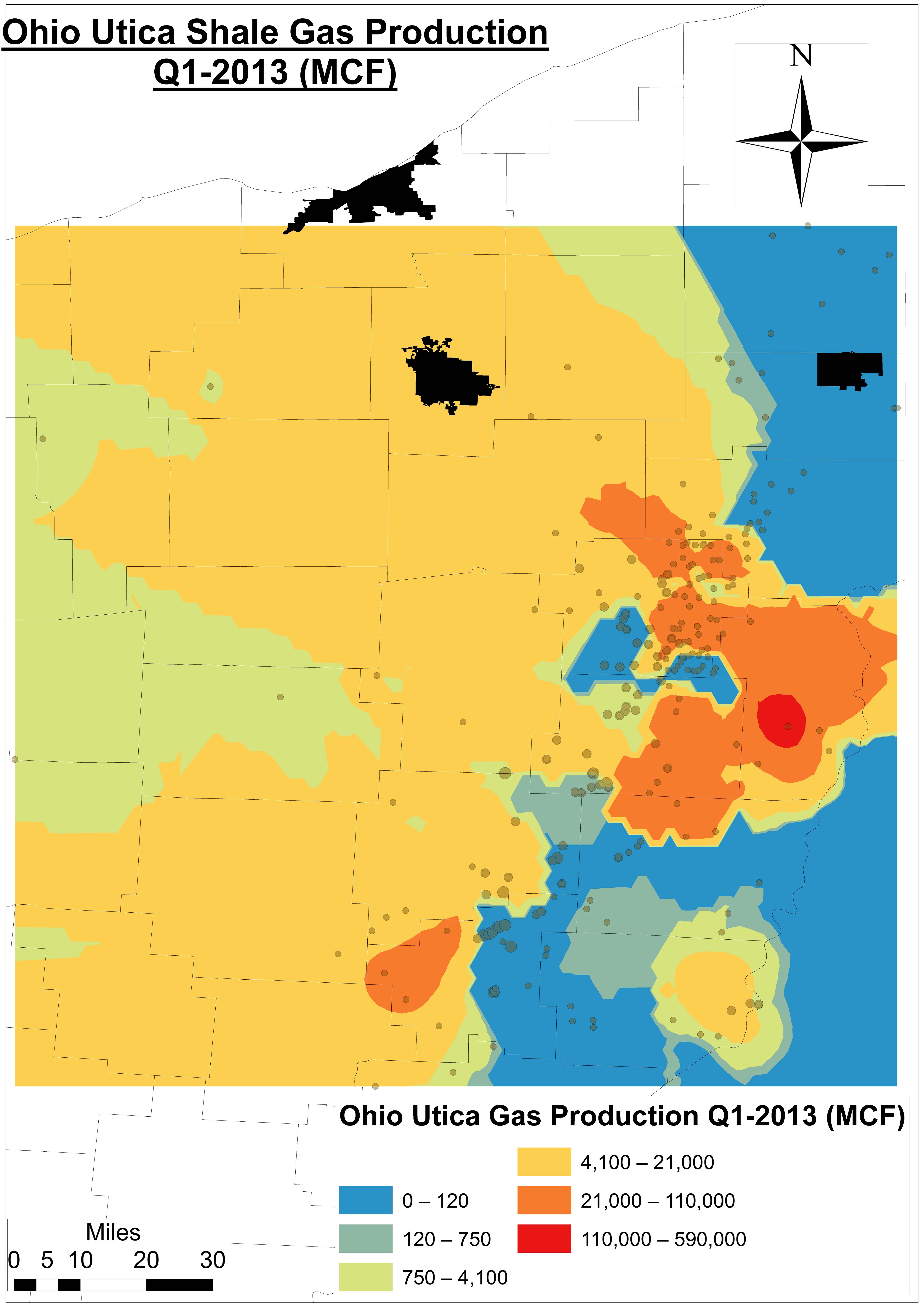
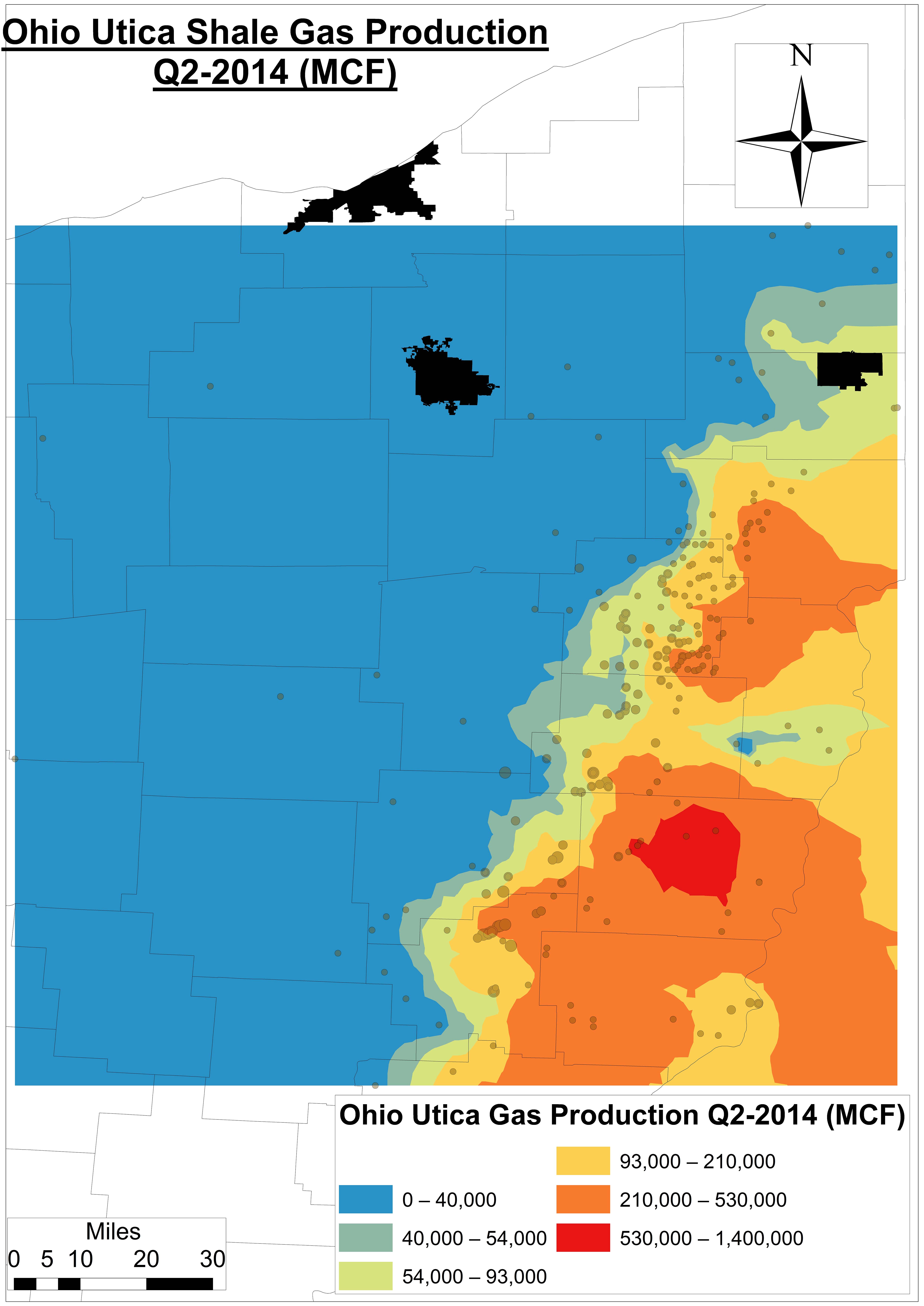
However, our analysis demonstrates that (Figures 7 and 8):
This is a rapidly moving target,
The big red blob isn’t as big – or continuous – as once projected, and
It might not even include many of the counties once thought to be the heart of the OH Utica shale play.
This last point is important because counties, families, investors, and outside interests were developing investment and/or savings strategies based on this map and a 30+ year timeframe – neither of which may be even remotely close according to our model.
Figure 7a. An Ohio Utica Shale oil production model using Kriging6 for Q1-2013
Figure 7b. An Ohio Utica Shale oil production model using Kriging for Q2-2014
Figure 8a. An Ohio Utica Shale gas production model using Kriging for Q1-2013
Figure 8b. An Ohio Utica Shale gas production model using Kriging for Q2-2014
Footnotes
$4.25 per 1,000 gallons, which is the current going rate for freshwater at OH’s MWCD New Philadelphia headquarters, is 4.7-8.2 times less than residential water costs at the city level according to Global Water Intelligence.
Carroll County wells have seen days in production jump from 36-62 days in 2011-2012 to 68-78 in 2014 across 256 producing wells as of Q2-2014.
One Mcf is a unit of measurement for natural gas referring to 1,000 cubic feet, which is approximately enough gas to run an American household (e.g. heat, water heater, cooking) for four days.
Assuming average oil and natural gas prices of $96 per barrel and $8.67 per Mcf during the current period of production (2011 to Q2-2014), respectively
On a per-API# basis or even regional basis we have not found drilling muds data. We do have it – and are in the process of making sense of it – at the Solid Waste District level.
https://www.fractracker.org/a5ej20sjfwe/wp-content/uploads/2014/11/Nexus2-Feature.png400900Ted Auch, PhDhttps://www.fractracker.org/a5ej20sjfwe/wp-content/uploads/2021/04/2021-FracTracker-logo-horizontal.pngTed Auch, PhD2014-11-17 17:00:262020-07-21 10:34:07The Water-Energy Nexus in Ohio, Part II
When the unconventional oil and gas extraction boom hit Pennsylvania in the mid-2000s small, local operators were among the first on the scene. As shale plays continued to develop, many of these smaller companies were bought out by larger, national corporations. Larger oil and gas development companies often maintain that they are better able to handle the expected regulatory requirements, and so FracTracker wanted to determine if there was a change in the compliance record for wells that changed hands. Does having more resources available to them translate into stronger compliance standards for oil and gas drillers, better training for their employees, and a greater burden to get things right? Investigating these questions by looking into compliance data and the sale of wells, however, was no easy task.
Analysis Methods
There are no indications in either the drilled wells or permits datasets available from the DEP that a well has changed hands; in both of these sources, one operator’s name is simply substituted for the other. It is possible to comb through old news stories, and find that East Resources sold its assets to Shell in 2010, for example. However, this approach is piecemeal, and would not lead to satisfactory results on an industry-wide analysis.
Major obstacles to our analysis included:
Lack of information on the transfer of oil and gas wells from one operator to another
There is often a lag time between the time violations occur and when they are reported
Errors in compliance reporting. For example, one API Number was found to have the operator listed as “Not Assigned” (It was later discovered that this well was never sold).
Results
Unlike wells and permits, any items on the compliance dataset are attributed to whichever company was operating the well at the time the violation was issued. So while FracTracker could not do the analysis that we wanted to because of the limitations of available data, we were able to isolate 30 wells that have changed hands between January 1, 2000 and November 4, 2014 (Table 1). One well has been bought and sold twice, with each of the three operators being issued violations.
In some instances the original well owner was reported to be out of compliance more times than the second owner. For example, API Number 013-20012 had 11 violations reported under its first owner and only 1 since it has been sold. The contrary also occurred, however, such as in the case of API Number 065-26481, which had 4 violations reported under its first owner and 14 under its second owner. There are not enough data points to determine which scenario is the trend in the data – if in fact there is one.
Due to limitations in the data, we cannot currently evaluate whether the notion that larger companies can improve the track record of problematic wells. In fact, many of the wells that were issued violations for multiple operators really just changed hands from one big operator who wanted to get out of the Marcellus to another big operator who wanted to get in. Our small sample doesn’t include any of the wells that were issued violations to only one company, of all the wells that changed hands over the years. To accurately assess the scenario, more data would have to be released, specifically the date when wells changed hands from one company to another.
Table 1. Wells with violations by API number that have changed ownership
API Number
First Owner
Last Known Date Of Ownership
Second Owner
First Known Date Of Ownership
Third Owner
First Known Date Of Ownership
013-20012
Chief Oil & Gas LLC
5/24/10
Chevron Appalachia LLC
2/5/13
015-20033
Belden & Blake Corp
4/10/09
Chesapeake Appalachia LLC
12/7/11
015-20051
Consol Gas Co
6/16/04
Range Resources Appalachia LLC
8/9/05
Talisman Energy USA Inc
11/16/11
019-21494
Phillips Exploration Inc
6/10/08
XTO Energy Inc
7/24/13
019-21680
Phillips Exploration Inc
4/6/10
XTO Energy Inc
3/13/13
065-26481
Dannic Energy Corp
5/11/11
Mieka LLC
11/10/11
065-26832
Dannic Energy Corp
3/2/11
Mieka LLC
4/11/12
081-20062
Chief Oil & Gas LLC
1/6/09
Exco Resources Pa LLC
8/16/11
081-20069
Chief Oil & Gas LLC
5/21/08
Exco Resources Pa LLC
3/28/11
081-20128
Chief Oil & Gas LLC
11/15/10
Exco Resources Pa LLC
6/27/11
081-20144
Chief Oil & Gas LLC
7/21/10
Exco Resources Pa LLC
3/15/12
081-20149
Chief Oil & Gas LLC
1/10/11
Exco Resources Pa LLC
2/21/12
081-20244
Chief Oil & Gas LLC
5/20/10
Exco Resources Pa LLC
11/15/12
081-20255
Chief Oil & Gas LLC
11/15/10
Exco Resources Pa LLC
11/29/11
081-20279
Chief Oil & Gas LLC
12/3/10
Exco Resources Pa LLC
4/20/12
081-20298
Chief Oil & Gas LLC
5/26/10
Exco Resources Pa LLC
6/27/11
083-53843
Anschutz Exploration Corp
4/7/09
Chesapeake Appalachia LLC
3/20/13
113-20025
Chief Oil & Gas LLC
2/15/11
Exco Resources Pa LLC
3/16/11
113-20049
Chief Oil & Gas LLC
11/30/10
Exco Resources Pa LLC
4/13/11
115-20052
Turm Oil Inc
9/24/08
Chesapeake Appalachia LLC
8/21/14
115-20169
Alta Opr Co LLC
11/24/09
WPX Energy Appalachia LLC
4/13/11
115-20174
Alta Opr Co LLC
4/16/10
Wpx Energy Appalachia LLC
4/29/11
115-20191
Alta Opr Co LLC
12/1/09
Wpx Energy Appalachia LLC
6/1/11
115-20214
Alta Opr Co LLC
7/19/10
Wpx Energy Appalachia LLC
8/16/10
115-20231
Alta Opr Co LLC
4/8/10
Wpx Energy Appalachia LLC
6/1/11
117-20197
East Resources Inc
4/8/08
Talisman Energy USA Inc
1/26/11
117-20280
East Resources Inc
5/19/10
Swepi LP
8/28/14
117-20330
East Resources Inc
12/18/09
Talisman Energy USA Inc
2/20/13
117-20394
East Resources Inc
12/14/09
Swepi LP
10/25/11
117-20538
East Resources Inc
12/18/10
Swepi LP
5/27/10
https://www.fractracker.org/a5ej20sjfwe/wp-content/uploads/2014/11/Comparison-Feature.png400900FracTracker Alliancehttps://www.fractracker.org/a5ej20sjfwe/wp-content/uploads/2021/04/2021-FracTracker-logo-horizontal.pngFracTracker Alliance2014-11-12 14:47:302020-07-21 10:34:07Comparison of Oil and Gas Violations and the Sale of Wells
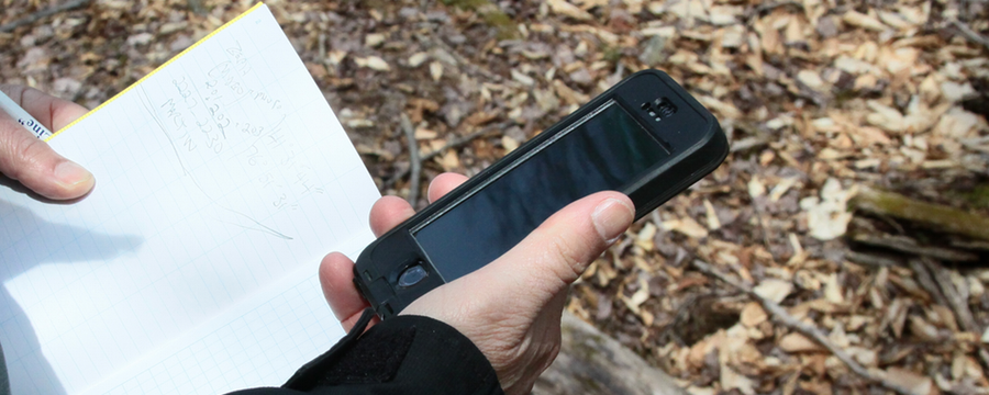
Pittsburgh, PA – FracTracker Alliance announces the release of our free iPhone app – designed to collect and share experiences related to oil and gas drilling across the United States. As unconventional drilling or “fracking” intensifies, so too do the innovative ways in which citizens can track, monitor, and report potential issues from their smart phones.
The app allows users to submit oil and gas photos or reports. Users can also view a map of wells drilled near them and user-submitted reports. This map shows wells that have been drilled both unconventionally and conventionally.
“FracTracker’s app contributes to the collective understanding of oil and gas impacts and provides a new opportunity for public engagement,” explains Brook Lenker, Executive Director of the FracTracker Alliance. “We hope that our mobile app will revolutionize how people share oil and gas information.”
Development Partners
Several organizations and community groups helped to test and improve the app during its development. To address questions about the impacts of oil and gas development across landscapes, FracTracker joined with the National Parks Conservation Association (NPCA) to create a crowd-sourced digital map with photos detailing the scale of oil and gas development near North Dakota’s Theodore Roosevelt National Park using the app. The photo map is part of a NPCA’s campaign designed to educate citizens about the cross-landscape impacts of oil and gas development near America’s national parks. NPCA is hosting two events this week in support of this campaign work – in Pittsburgh and Philadelphia.
“FracTracker’s new app allows us to tell a visual story about fracking’s impacts to national parks and their local communities,” said Nick Lund, who manages the NPCA’s Landscape Conservation program. “With this week’s public events in Pittsburgh and Philadelphia, we will show the dramatic impact that fracking continues to have, in just a few years, near Theodore Roosevelt National Park. These images can help inform the public and our elected officials as they finalize drilling regulations in Pennsylvania. We hope this information will lead to strong protections for our national parks, our forests, and our drinking water.”
Beta testing and reviews of the app were also conducted by Mountain Watershed Association, Responsible Drilling Alliance, Audubon PA, PA Forest Coalition, Southwest PA Environmental Health Project, and Save Our Streams PA. The app was developed in collaboration with Viable Industries, L.L.C.
Like NPCA, groups can use the FracTracker app to collect visual data and develop customized maps for their own projects. Contact FracTracker to learn more: info@fractracker.org.
Download the App
Download the free app from the iTunes store or visit FracTracker.org to learn more: www.fractracker.org/apps. Currently the app is only available for only iPhone users, but an Android platform is due out later this year.
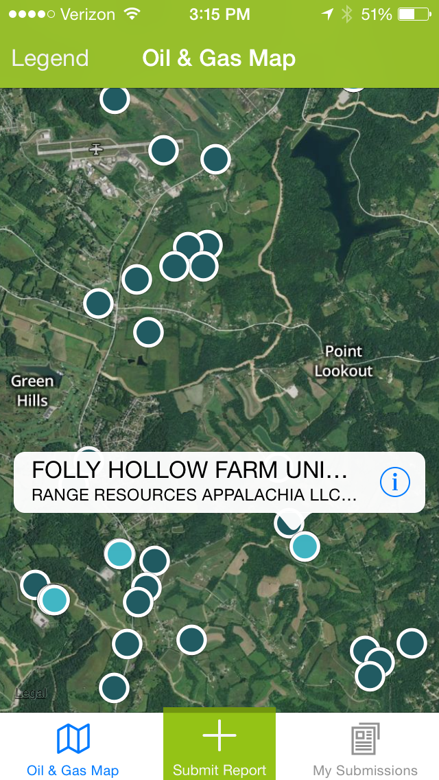
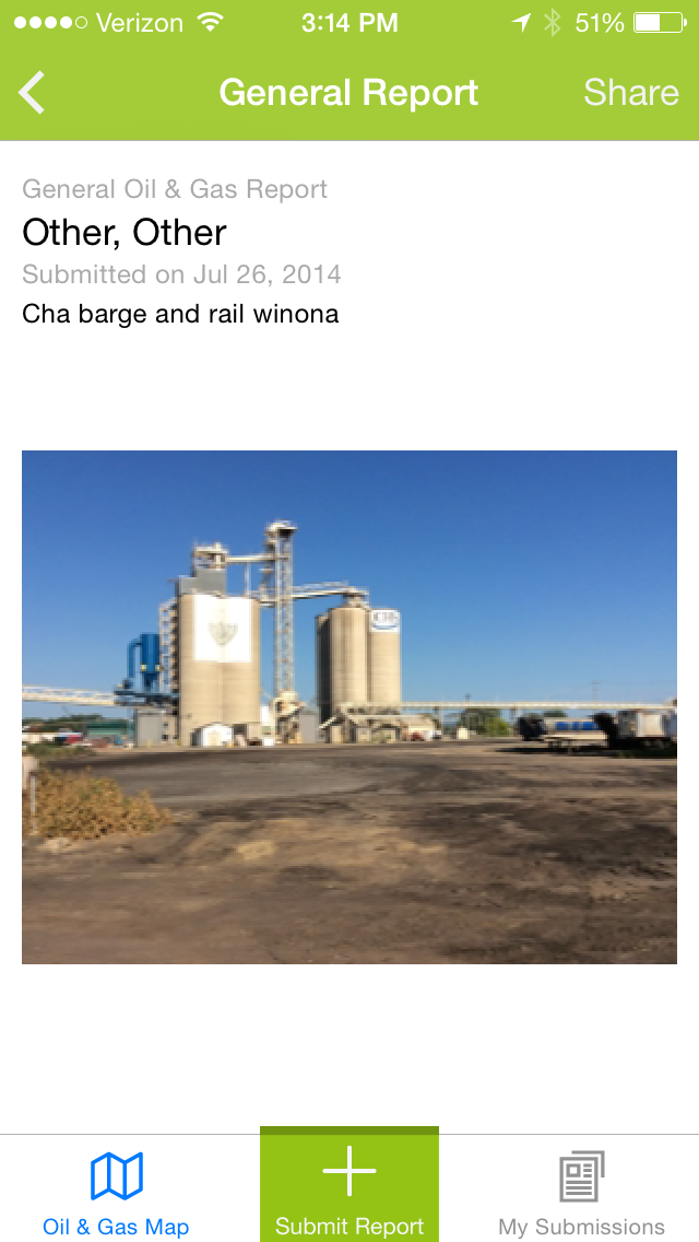
App Screenshots
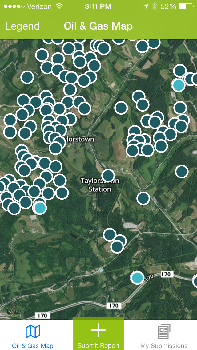
See a map of wells near you or submit a report.
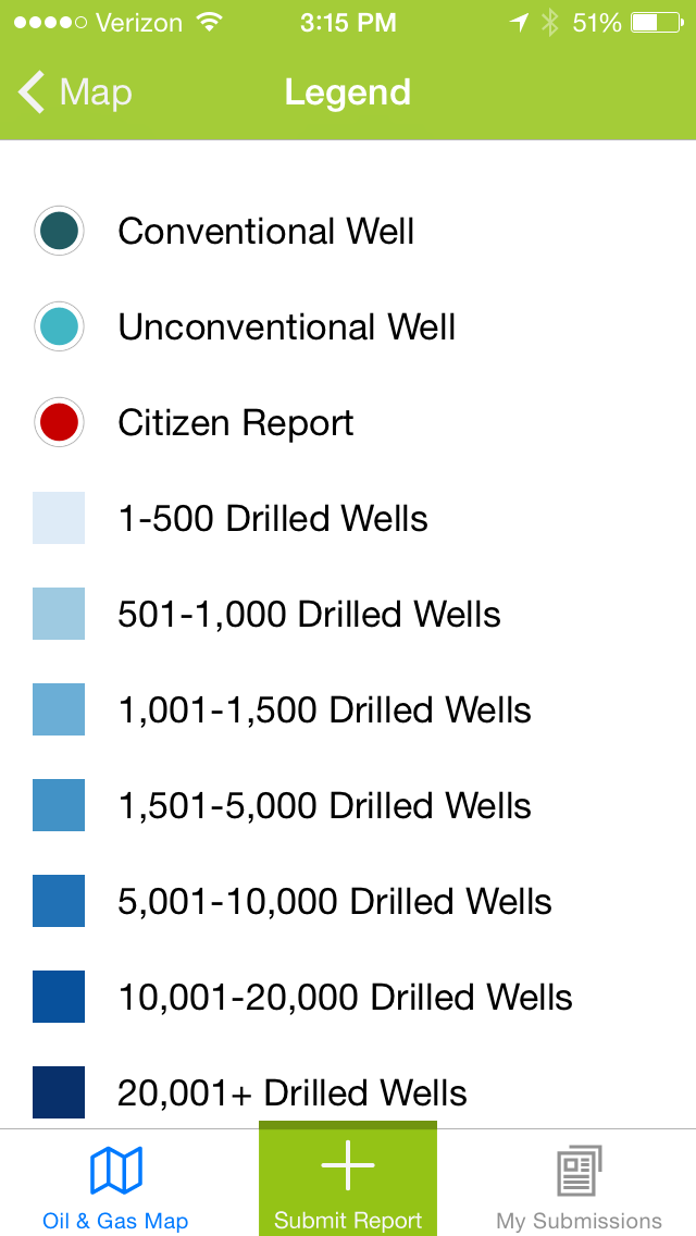
The legend describes the points on the map in more detail.
Clicking on a dot shows the record/well
Clicking the “i” shows you more information about the point
FracTracker Alliance is a non-profit organization with offices in PA, OH, NY, WV, and CA that shares maps, data, and analyses to communicate impacts of the global oil and gas industry and inform actions that positively shape our energy future. Learn more about FracTracker at www.fractracker.org.
National Parks Conservation Association: Since 1919, the nonpartisan National Parks Conservation Association has been the leading voice of the American people in protecting and enhancing our National Park System. NPCA, its one million members and supporters, and many partners work together to protect the park system and preserve our nation’s natural, historical, and cultural heritage for our children and grandchildren. For more information, please visit www.npca.org.
https://www.fractracker.org/a5ej20sjfwe/wp-content/uploads/2014/11/iPhone-App-Feature.png400900FracTracker Alliancehttps://www.fractracker.org/a5ej20sjfwe/wp-content/uploads/2021/04/2021-FracTracker-logo-horizontal.pngFracTracker Alliance2014-11-12 09:43:012020-07-21 10:34:06FracTracker Launches Oil and Gas Tracking App