Quick Sand: Frack Sand Mining in Wisconsin
Each silica sand mine displaces 871 acres of wetlands and more than 12 square miles of forests and agriculture land in Wisconsin to provide the shale gas industry with fracking proppant.
By Juliana Henao, Communications Intern
Silica sand is used by the oil and gas industry as a way to prop open the fractures made during fracking – and is also referred to as a proppant. The industry’s demand for silica sand is steadily increasing (i.e., 4-5K tons per shale lateral, +86 tons per lateral per quarter), directly affecting the Great Lakes, their ecosystems, and land use. Silica sand is often found in Wisconsin and Michigan, which have felt the effects of increased sand mining demands through altered landscapes, impacted ecosystem productivity, and altering watershed resilience; these impacts will only continue to increase as the demand for silica sand increases.
To better understand frack sand mining’s current and potential effects, FracTracker’s Ted Auch and intern Elliott Kurtz, with generous support from the Save The Hills Alliance, explored mining and land use changes data in West Central Wisconsin (WCW). In their research paper, Auch and Kurtz show the current and future environmental impacts of increased sand mining in WCW in order to supply the oil and gas industry with sand. Not only does this research illustrate what is at risk in the WCW landscape, it also showcases what sand mining has already done to the region.
Key Frack Sand Mining Findings
Land alterations due to silica sand mining in WI
Sixteen percent, or 2,396 square miles, of the West Central Wisconsin (WCW) is made up of wetlands or open waters. These and the other existing WCW landscapes are unquestionably profitable. The forests buffer climate change impacts – to date accumulating between 4.8-9.8 billion tons of CO2 assuming they are 65-85 years old – and have a current stumpage value of $253-936 million.
The 25 producing silica mines in this region occupy 12 square miles of WCW and have already displaced:
- 3 mi2 of forests
- 7 mi2 of agricultural land-cover
- 1.36 mi2 of wetlands (equal to 11% of all mined lands)
Formerly, these wetlands were one of three types:- 18% (158 acres) forested wetlands
- 41% (353 acres) lowland shrub wetlands, and
- 41% (361 acres) emergent/wet meadows
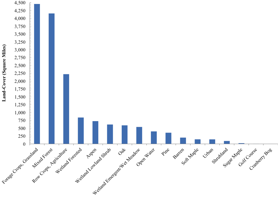
Breakdown of the current landscape types near these expanding mines, based on an analysis of satellite imagery
Why Wisconsin?
There are more than 125 silica sand mines throughout WCW, a stretch of ~16,000 square miles. Previously, the mining industry focused their efforts in Oklahoma and Texas’s Riley, Hickory/Brady, and Old Creek formations, where the land is not as agriculturally or ecologically productive as WCW. Now, more and more mines are being proposed and built in the WCW region. We wanted to determine what this change would mean for such an ecosystem diverse area of Wisconsin – many of which are considered “globally imperiled” or “globally rare” including oak savanna, dry prairies, southern dry-mesic forests, pine barrens, moist cliffs and oak openings.
The St. Peter Sandstone – along with the early Devonian and much smaller Sylvania Sandstone in Southeastern Michigan – is the primary target of the silica sand industry. Carbon-rich grassland soils cover 36% of the St. Peter, where they aid the ecosystem by capturing and sorting 20.9 tons of CO2 per year, as well as purifying precipitation inputs. This ecosystem, amongst many others around sand mining activities, will be dramatically altered if silica sand mining continues at its increasing rate. We will see CO2 capturing levels drop from 20.9 tons to 10.6 tons per acre per year if the highly productive temperate forests are not reassembled and reclaimed to their original acreage, as well as a significant loss (75%) in agricultural productivity on sites that are not reclaimed properly.
Out-of-state mining companies are settling into Wisconsin and displacing the land at a very high rate. As the president of Iowa’s Allamakee County Protectors Ric Zarwell told us by email “Frac sand mining companies do not come from the area where I live. So efforts to destroy landscapes for frac sand are going to involve Neighbors Opposing Invaders.”
A high demand in silica sand from the shale gas industry will continue to drive this influx of mining companies into WI, providing a potentially collapsed ecosystem in the future. Factors at play include additional – and often much larger – mines under consideration, the average shale gas lateral grows by > 50 feet per quarter, and silica sand usage will grow from 5,500 tons to > 8,000 tons per lateral (i.e., 85 tons per quarter per lateral). Auch and Kurtz’s research paper describes in detail where how much silica sand might be needed in the future, as well as a detailed set of maps depicting land cover and usage in WI.