Nearly 2 Million Pennsylvanians Live Within a Kilometer of Oil & Gas Wells
By Matt Kelso, Manager of Data & Technology
In October 2014, the FracTracker Alliance performed an analysis showing an estimated 1.2 million people lived within a half mile of oil and gas wells in Pennsylvania. We have now updated the analysis, but this time, the unit of measure is one kilometer (0.62 miles).
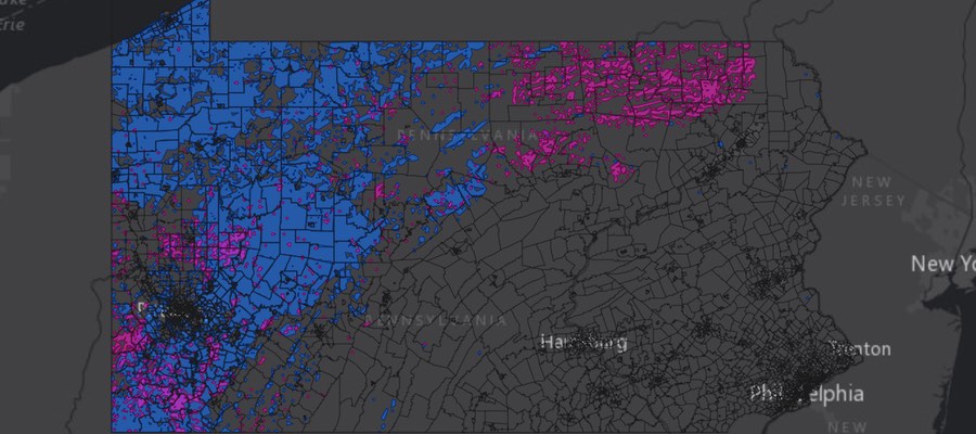
PA Population Within 1km of Active Oil and Gas Wells
This map shows the estimated population within one kilometer of active oil and gas wells in PA – a total of nearly 2 million Pennsylvanians. To access the full set of tools and details about how the map was made, click here for the full screen version of the map.
Methods
To get as complete a picture as possible of the oil and gas industry in PA, we queried the spud date report to show all wells that were listed as being spudded between January 1, 1800 and November 12, 2015. We used the former date because it appears to be a default for unknown spud dates, and the latter being the date that the data were downloaded for the analysis. Altogether, this yielded 203,887 oil and gas wells throughout the state, but 74,900 (37%) of these lacked location coordinates. All of those missing latitude and longitude data were classified as conventional wells, and many of them were fairly old. We then filtered out wells that were reported as not being drilled, as well as those that were permanently plugged, either by the operator, or by the PA Department of Environmental Protection (PADEP). The resulting set, which we refer to as “active” oil and gas wells, included 106,970 wells, of which 9,042 (8%) are defined as unconventional wells by the state.
To obtain an estimated population, we used the Census Tract level of detail, using official 2010 population figures. We calculated the area within 1 kilometer of active wells in three categories – conventional, unconventional, and all oil and gas wells. The population was then estimated by comparing the area inside the 1 km zone to the entire Census Tract, multiplying that ratio to the population of that tract, and repeating the process for each of the three datasets.
This area calculation was performed in Albers Equal Area projection optimized for the Great Lakes Basin area. Every method of flattening an area of a globe on the map will lead to some type of distortion, but this projection prioritizes area over other factors, and is therefore appropriate for this type of analysis.
Results
An additional year of drilling activity, a more comprehensive date range, and the slight increase of the radius distance has had a significant effect on the estimated population near wells. The 2014 analysis yielded an estimated 1,264,576 within a half-mile of wells, while the current analysis has the figure at 1,965,837, an increase of 55%. Below is a table showing differences between the two analyses:
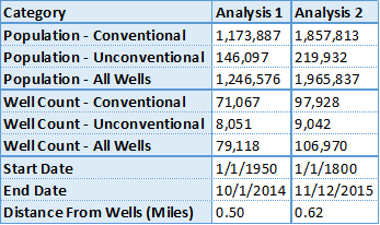
This chart shows summaries of the current analysis of population within 1 km of wells in PA and an October 2014 version, showing population within a half-mile of wells.
One thing you will notice in this figure is that simply adding up the number of people who live in areas near unconventional and conventional drilling will not get you to the 1,965,837 figure we’ve presented. This is because some people live within the specified distance of both types of wells.
Additionally, it is impossible to say how many people live near the oil and gas wells that lack location data, as we obviously can’t map these wells. The majority of these wells may be in the areas that are already represented in the buffer zones, or they may extend that distance significantly.