Pipeline Under Debate in Louisiana Bayou
The 30-inch Bayou Bridge Pipeline began operations in April of 2016, with a short leg of pipeline that ran from Nederland, Texas to refineries in Lake Charles, Louisiana. But this 60-mile long pipeline, operated by Sunoco Logistics Partners, was just the first step in a much lengthier, and more controversial, 24-inch diameter pipeline project (jointly owned by Sunoco Logistics Partners, as well as Phillips 66 Partners and Energy Transfer Partners). Nonetheless, Bayou Bridge Pipeline, LLC argues that transport of crude oil by pipeline rather than by tanker or train, is the safest transportation option, as they continue to advocate and justify more pipeline construction in the name of “energy independence.” They compare its necessity to that of FedEx, a mere “delivery system”—one that would carry 280,000 barrels of light or heavy crude across the Acadiana terrain. The company building the pipeline, in fact, distances itself from problems that could result after oil starts flowing:
The pipeline is merely a delivery system, similar to FedEx, to help fill a need that already exists to ship the crude to refiners and market. We do not own the crude in the pipeline,” Alexis Daniel, of Granado Communications Group, a public relations firm in Dallas, wrote in an email response to questions posed to Energy Transfer Partners. Source
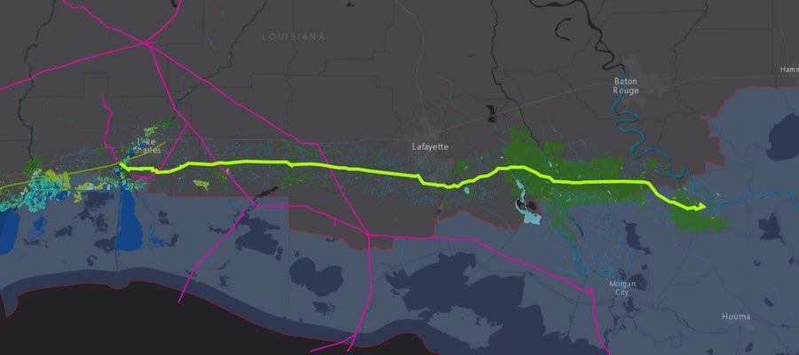
Developers hope that second phase of the proposed Bayou Bridge Pipeline will be put into operation during the second half of 2017. It would run 162 miles from Lake Charles, LA to refineries in St James, LA. It would cross the 11 Louisiana parishes and over 700 acres of fragile wetlands, and watersheds that supply drinking water for up to 300,000 people. Pump stations are planned for Jefferson Davis and St. Martin parishes. St. James is located on the western bank of the Mississippi River, about 50 miles upstream of New Orleans. In addition, the proposed pipeline crosses the state-designated Coastal Zone Boundary, an area targeted by Louisiana for special consideration relating to ecological and cultural sustainability.
Map of Proposed Louisiana Bayou Bridge Pipeline
View map fullscreen | How FracTracker maps work
Zoom in closer to the area around the Bayou Bridge Pipeline, and the National Wetlands Inventory data should appear. Use the “Bookmarks” tab to zoom in close to the refinery sites, and also to zoom back out to the full extent of the proposed Bayou Bridge Pipeline.
What’s the connection to the DAPL?
The 2010 BP Gulf oil spill resulted in $18 billion in settlements and penalties. With protests in the news about the impacts the Dakota Access Pipeline (DAPL) could pose to drinking water for the Standing Rock Sioux Reservation should another oil spill occur along the Missouri River, it’s no surprise that environmentalists are also calling for an environmental impact statement about the proposed extension of the Bayou Bridge Pipeline.
Acadiana is already criss-crossed by a dense network of pipelines leading to Gulf Coast refineries. Nonetheless, the process of building the proposed Bayou Bridge pipeline, the Atchafalaya Basin, a major watershed of the Gulf of Mexico, will see additional and significant impacts. Even if the construction process happens without a hitch, 77 acres of wetlands would be permanently affected, and 177 acres would be temporarily affected, along with the wildlife and aquatic species that live there. Within a 5-mile buffer area of the pipeline, National Wetlands Inventory has mapped over 600 square miles of forested wetlands, nearly 300 square miles of estuarine wetlands, and 63 square miles of freshwater emergent wetlands. Essential ecosystem services that the wetlands provide, absorbing floodwaters, could be compromised, leading to increased erosion and sedimentation downstream. Impacts to these wetlands could be greatly magnified into the already environmentally stressed Gulf.
The connection between DAPL and Bayou Bridge is both figurative and literal. Like most new pipelines, concerns about spills loom large in the minds of many. A new pipeline represents more money that is not being directed toward clean energy alternatives.
Energy Transfer Partners, the same company building DAPL, is also building the Bayou Bridge, which the final leg of the Dakota Access Pipeline, 1300 miles to the north. The two pipelines would be connected by a 700+-mile-long stretch of Energy Transfer Partner’s 30-inch Trunkline. This pipeline, which has been a gas transmission line, was proposed in 2012 for conversion from gas to crude transport. The project was cancelled in 2014, and reworked to use 678 miles of the original Trunkline, and also add 66 miles of new pipeline. When it is online, the flow direction of the Trunkline pipeline would reversed to accommodate the south-flowing crude.
Other unanticipated impacts
Interestingly, if crude oil transport to Gulf Coast refineries is diverted to pipelines rather than traditional rail or barge transport, some industry analysts predict that transportation using those modes of conveyance will shift more to the Atlantic and Pacific coasts.
A chance for public input
Environmental groups, including a coalition the comprises the Sierra Club, the Gulf Restoration Network, and the Louisiana Bucket Brigade, the Atchafalaya Basinkeeper, as well as concerned citizens, and landowners (some of whom already have multiple pipelines crossing their properties) are making their resistance to the pipeline heard, loud and clear about the need for a full environmental impact statement that will address the cumulative and indirect impacts of the project.
Update, 6 February 2017. Here’s an article that features information about the January 12 public meeting, which was packed to capacity.
By Karen Edelstein, Eastern Program Coordinator, FracTracker Alliance
Added to my story about the pipeline protest –
https://lasinkhole.wordpress.com/2018/03/02/bayou-bridge-pipeline/
I think the LDEQ is going to have to move the Jan 12th Public Hearing to a bigger venue, like a stadium. This wont just be a public outcry, it will be a public roar, as in, “Not In My Bayou.”