The Falcon: Methods, Mapping, & Analysis
Part of the Falcon Public EIA Project
FracTracker began monitoring Falcon’s construction plans in December 2016, when we discovered a significant cache of publicly visible GIS data related to the pipeline. At that time, FracTracker was looking at ways to get involved in the public discussion about Shell’s ethane cracker and felt we could contribute our expertise with mapping pipelines. Below we describe the methods we used to access and worked with this project’s data.
Finding the Data
![]() Finding GIS data for pipeline projects is notoriously difficult but, as most research goes these days, we started with a simple Google search to see what was out there, using basic keywords, such as “Falcon” (the name of the pipeline), “ethane” (the substance being transported), “pipeline” (the topic under discussion), and “ArcGIS” (a commonly used mapping software).
Finding GIS data for pipeline projects is notoriously difficult but, as most research goes these days, we started with a simple Google search to see what was out there, using basic keywords, such as “Falcon” (the name of the pipeline), “ethane” (the substance being transported), “pipeline” (the topic under discussion), and “ArcGIS” (a commonly used mapping software).
In addition to news stories on the pipeline’s development, Google returned search results that included links to GIS data that included “Shell” and “Falcon” in their names. The data was located in folders labeled “HOUGEO,” presumably the project code name, as seen in the screenshot below. All of these links were accessed via Google and did not require a password or any other authentication to view their contents.
Shell’s data on the Falcon remained publicly available at this link up to the time of the Falcon Public EIA Project‘s release. However, this data is now password protected by AECOM.

Viewing the Data
![]() The HOUGEO folder is part of a larger database maintained by AECOM, an engineering firm presumably contracted to prepare the Falcon pipeline construction plan. Data on a few other projects were also visible, such as maps of the Honolulu highway system and a sewer works in Greenville, NC. While these projects were not of interest to us, our assessment is that this publicly accessible server is used to share GIS projects with entities outside the company.
The HOUGEO folder is part of a larger database maintained by AECOM, an engineering firm presumably contracted to prepare the Falcon pipeline construction plan. Data on a few other projects were also visible, such as maps of the Honolulu highway system and a sewer works in Greenville, NC. While these projects were not of interest to us, our assessment is that this publicly accessible server is used to share GIS projects with entities outside the company.
Within the HOUGEO folder is a set of 28 ArcGIS map folders, under which are hundreds of different GIS data layers pertaining to the Falcon pipeline. These maps could all be opened simply by clicking on the “ArcGIS Online map viewer” link at the top of each page. Alternatively, one can click on the “View in: Google Earth” link to view the data in Google Earth or click on the “View in: ArcMap” link to view the data in the desktop version of the ArcGIS software application. No passwords or credentials are required to access any of these folders or files.
As seen in the screenshot below, the maps were organized topically, roughly corresponding to the various components that would need to be addressed in an EIA. The “Pipeline” folder showed the route of the Falcon, its pumping stations, and work areas. “Environmental” contained data on things like water crossings and species of concern. “ClassLocations” maps the locations of building structures in proximity to the Falcon.

Archiving the Data
![]() After viewing the Falcon GIS files and assessing them for relevancy, FracTracker went about archiving the data we felt was most useful for our assessing the project. The HOUGEO maps are hosted on a web server meant for viewing GIS maps and their data, either on ArcOnline, Google Earth, or ArcMap. The GIS data could not be edited in these formats. However, viewing the data allowed us to manually recreate most of the data.
After viewing the Falcon GIS files and assessing them for relevancy, FracTracker went about archiving the data we felt was most useful for our assessing the project. The HOUGEO maps are hosted on a web server meant for viewing GIS maps and their data, either on ArcOnline, Google Earth, or ArcMap. The GIS data could not be edited in these formats. However, viewing the data allowed us to manually recreate most of the data.
For lines (e.g. the pipeline route and access roads), points (e.g. shutoff valves and shut-off valves), and certain polygons (e.g. areas of landslide risk and construction workspaces), we archived the data by manually recreating new maps. Using ArcGIS Desktop software, we created a new blank layer and manually inputted the relevant data points from the Falcon maps. This new layer was then saved locally so we could do more analysis and make our own independent maps incorporating the Falcon data. In some cases, we also archived layers by manually extracting data from data tables underlying the map features. These tables are made visible on the HOUGEO maps simply by clicking the “data table” link provided with each map layer.
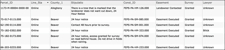
Other layers were archived using screen captures of the data tables visible in the HOEGEO ArcOnline maps. For instance, the table below shows which parcels along the route had executed easements. We filtered the table in ArcGIS Online to only show the parcel ID, survey status, and easement status. Screen captures of these tables were saved as PDFs on our desktop, then converted to text using optical character recognition (OCR), and the data brought into Microsoft Excel. We then recreated the map layer by matching the parcel IDs in our newly archived spreadsheet to parcel IDs obtained from property GIS shapefiles that FracTracker purchased from county deeds offices.
Transparency & Caveats
![]() FracTracker strives to maintain transparency in all of its work so the public understands how we obtain, analyze, and map data. A good deal of the data found in the HOUGEO folders are available through other sources, such as the U.S. Geological Survey, the Department of Transportation, and the U.S. Census, as well as numerous state and county level agencies. When possible, we opted to go to these original sources in order to minimize our reliance on the HOUGEO data. We also felt it was important to ensure that the data we used was as accurate and up-to-date as possible.
FracTracker strives to maintain transparency in all of its work so the public understands how we obtain, analyze, and map data. A good deal of the data found in the HOUGEO folders are available through other sources, such as the U.S. Geological Survey, the Department of Transportation, and the U.S. Census, as well as numerous state and county level agencies. When possible, we opted to go to these original sources in order to minimize our reliance on the HOUGEO data. We also felt it was important to ensure that the data we used was as accurate and up-to-date as possible.
For instance, instead of manually retracing all the boundaries for properties with executed easements for the Falcon’s right-of-way, we simply purchased parcel shapefiles from county deeds and records offices and manually identified properties of interest. To read more on how each data layer was made, open any of our Falcon maps in full-screen mode and click the “Details” tab in the top left corner of the page.
Finally, some caveats. While we attempted to be as accurate as possible in our methods, there are aspects of our maps where a line, point, or polygon may deviate slightly in shape or location from the HOUGEO maps. This is the inherent downside of having to manually recreate GIS data. In other cases, we spent many hours correcting errors found in the HOUGEO datasets (such as incorrect parcel IDs) in order to get different datasets to properly match up.
![]() FracTracker also obtained copies of Shell’s permit applications in January by conducting a file review at the PA DEP offices. While these applications — consisting of thousands of pages — only pertain to the areas in Pennsylvania where the Falcon will be built, we were surprised by the accuracy of our analysis when compared with these documents. However, it is important to note that the maps and analysis presented in the Falcon Public EIA Project should be viewed with potential errors in mind.
FracTracker also obtained copies of Shell’s permit applications in January by conducting a file review at the PA DEP offices. While these applications — consisting of thousands of pages — only pertain to the areas in Pennsylvania where the Falcon will be built, we were surprised by the accuracy of our analysis when compared with these documents. However, it is important to note that the maps and analysis presented in the Falcon Public EIA Project should be viewed with potential errors in mind.
* * *