Pipelines
Learn about oil and gas pipeline impacts through FracTracker articles, maps, and imagery.
Learn about oil and gas pipeline impacts through FracTracker articles, maps, and imagery.
North America consists of a vast network of inter- and intrastate pipelines that transport products ranging from water to hazardous liquids to raw materials. The U.S. oil and gas pipeline network delivers trillions of cubic feet of natural gas and hundreds of billions of tons of liquid petroleum products each year. The infrastructure’s main environmental health and safety risks include land use and forest fragmentation, compressor station emissions, erosion and sedimentation, spills and leaks, and explosions.
Explore our site’s various articles about oil and gas pipeline issues below, listed in descending order by date.
In the summer of 2018, FracTracker released a detailed environmental impact assessment (EIA), including digital maps, of the Falcon Ethane Pipeline
 https://www.fractracker.org/a5ej20sjfwe/wp-content/uploads/2021/06/National-Map-2021-Feature.jpg
667
1500
Erica Jackson
https://www.fractracker.org/a5ej20sjfwe/wp-content/uploads/2025/09/2025-Wordmark-Logo.png
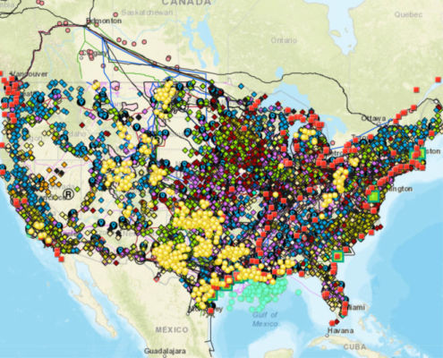
Erica Jackson2021-06-30 08:00:252022-05-02 15:24:21Updated National Energy and Petrochemical Map
https://www.fractracker.org/a5ej20sjfwe/wp-content/uploads/2021/06/National-Map-2021-Feature.jpg
667
1500
Erica Jackson
https://www.fractracker.org/a5ej20sjfwe/wp-content/uploads/2025/09/2025-Wordmark-Logo.png
Erica Jackson2021-06-30 08:00:252022-05-02 15:24:21Updated National Energy and Petrochemical Map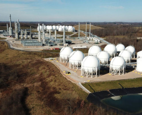 https://www.fractracker.org/a5ej20sjfwe/wp-content/uploads/2021/06/TAuch_Infrastructure-Hopedale_Cryogenic_Plant-MarkWest_Energy-HarrisonCounty-OH_Nov2020-Feature.jpg
667
1500
Ted Auch, PhD
https://www.fractracker.org/a5ej20sjfwe/wp-content/uploads/2025/09/2025-Wordmark-Logo.png
Ted Auch, PhD2021-06-11 12:26:292021-07-01 11:12:42Ohio, West Virginia, Pennsylvania Fracking Story Map
https://www.fractracker.org/a5ej20sjfwe/wp-content/uploads/2021/06/TAuch_Infrastructure-Hopedale_Cryogenic_Plant-MarkWest_Energy-HarrisonCounty-OH_Nov2020-Feature.jpg
667
1500
Ted Auch, PhD
https://www.fractracker.org/a5ej20sjfwe/wp-content/uploads/2025/09/2025-Wordmark-Logo.png
Ted Auch, PhD2021-06-11 12:26:292021-07-01 11:12:42Ohio, West Virginia, Pennsylvania Fracking Story Map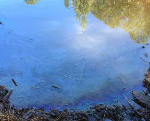 EPA
https://www.fractracker.org/a5ej20sjfwe/wp-content/uploads/2021/05/Colonial-pipeline-spill-feature.jpg
667
1500
Karen Edelstein
https://www.fractracker.org/a5ej20sjfwe/wp-content/uploads/2025/09/2025-Wordmark-Logo.png
Karen Edelstein2021-05-26 07:00:272023-07-18 10:31:34Impacts of 2020 Colonial Pipeline Rupture Continue to Grow
EPA
https://www.fractracker.org/a5ej20sjfwe/wp-content/uploads/2021/05/Colonial-pipeline-spill-feature.jpg
667
1500
Karen Edelstein
https://www.fractracker.org/a5ej20sjfwe/wp-content/uploads/2025/09/2025-Wordmark-Logo.png
Karen Edelstein2021-05-26 07:00:272023-07-18 10:31:34Impacts of 2020 Colonial Pipeline Rupture Continue to Grow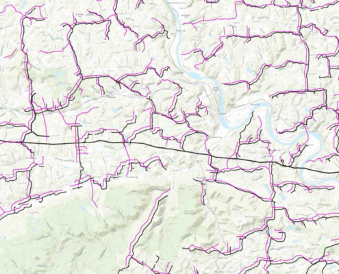 https://www.fractracker.org/a5ej20sjfwe/wp-content/uploads/2021/05/Bradford-County-PA-gathering-lines-feature.jpg
667
1500
Intern FracTracker
https://www.fractracker.org/a5ej20sjfwe/wp-content/uploads/2025/09/2025-Wordmark-Logo.png
Intern FracTracker2021-05-19 10:51:122021-05-20 14:41:22Mapping Gathering Lines in Bradford County, Pennsylvania
https://www.fractracker.org/a5ej20sjfwe/wp-content/uploads/2021/05/Bradford-County-PA-gathering-lines-feature.jpg
667
1500
Intern FracTracker
https://www.fractracker.org/a5ej20sjfwe/wp-content/uploads/2025/09/2025-Wordmark-Logo.png
Intern FracTracker2021-05-19 10:51:122021-05-20 14:41:22Mapping Gathering Lines in Bradford County, Pennsylvania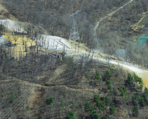 https://www.fractracker.org/a5ej20sjfwe/wp-content/uploads/2021/04/49770601811_6cc7e18996_k.jpg
716
1500
Matt Kelso, BA
https://www.fractracker.org/a5ej20sjfwe/wp-content/uploads/2025/09/2025-Wordmark-Logo.png
Matt Kelso, BA2021-04-14 15:01:522021-04-26 17:02:402021 Pipeline Incidents Update: Safety Record Not Improving
https://www.fractracker.org/a5ej20sjfwe/wp-content/uploads/2021/04/49770601811_6cc7e18996_k.jpg
716
1500
Matt Kelso, BA
https://www.fractracker.org/a5ej20sjfwe/wp-content/uploads/2025/09/2025-Wordmark-Logo.png
Matt Kelso, BA2021-04-14 15:01:522021-04-26 17:02:402021 Pipeline Incidents Update: Safety Record Not Improving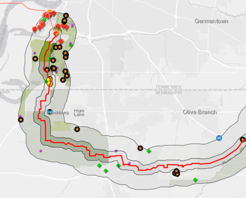 https://www.fractracker.org/a5ej20sjfwe/wp-content/uploads/2021/03/Byhalia-map-feature-2-scaled.jpg
667
1500
Karen Edelstein
https://www.fractracker.org/a5ej20sjfwe/wp-content/uploads/2025/09/2025-Wordmark-Logo.png
Karen Edelstein2021-03-17 17:06:302021-09-16 13:15:25Risky Byhalia Connection Pipeline Threatens Tennessee & Mississippi Health, Water Supply
https://www.fractracker.org/a5ej20sjfwe/wp-content/uploads/2021/03/Byhalia-map-feature-2-scaled.jpg
667
1500
Karen Edelstein
https://www.fractracker.org/a5ej20sjfwe/wp-content/uploads/2025/09/2025-Wordmark-Logo.png
Karen Edelstein2021-03-17 17:06:302021-09-16 13:15:25Risky Byhalia Connection Pipeline Threatens Tennessee & Mississippi Health, Water SupplyLooking for a map of US pipelines that you can access from your phone? Download our free mobile app.

![]()
216 Franklin St, Suite 400, Johnstown, PA 15901
Phone: +1 (717) 303-0403 | info@fractracker.org
FracTracker Alliance is a 501(c)3 non-profit: Tax identification number: 80-0844297

