Texas Drought Conditions and Water Availability

By Thomas DiPaolo, GIS Intern, FracTracker Alliance –

For the last three years, Texas has been experiencing a drought so severe that it has gained media attention around the world; the recurring theme from each media report is that the water use of the oil and natural gas industry is sucking up so much water from the ground that towns like Barnhart are seeing their taps run dry.


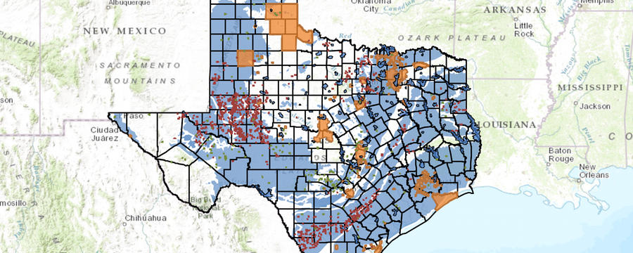
To view the fullscreen version of this map, including details about each layer, click here.

Surface Water

Water data for Texas, owned and operated by the Texas Water Development Board (TWDB), defines “reservoir storage” as the total volume of water contained within a reservoir, while “conservation storage” is specifically the volume of water that can be accessed and moved out of the reservoir. For example, the Twin Buttes Reservoir currently has 2,095 acre-feet of water in its reservoir storage, but because it cannot be removed from the reservoir, in terms of conservation storage it is considered “empty.” Twin Buttes is not the only reservoir in this position; Electra Lake, Meredith Lake, and White River Lake are also empty, and Electra Lake has no water at all in its reservoir storage. The average conservation storage of reservoirs statewide is 168,704.64 acre-feet. Ninety-two reservoirs (including the aforementioned) have less than that amount, while six reservoirs have conservation storages in excess of 1 million acre-feet. For reference, a TWDB report from last year found that in 2011 statewide fracking operations used a combined total of 81,500 acre-feet of water, over 26.5 billion gallons. That is almost enough to consume the conservation storage of the ten smallest reservoirs in the state.

The other measure for comparing water quantity is “fullness percentage,” a ratio between a reservoir’s current conservation storage and the maximum volume of water it can hold without flooding, or maximum conservation storage. Any reservoir with no conservation storage, therefore, has a fullness of 0%, while overflowing reservoirs are only 100% full. This means that, in contrast to the four reservoirs with 0% fullness, four other reservoirs have complete fullness. Monticello Reservoir, Mountain Creek Lake, and Squaw Creek Reservoir are all in excess of their conservation storages, but Houston Lake is flooding by the greatest amount, with reservoir storage of 139,409 acre-feet and conservation storage of 128,054 acre-feet. The average reservoir is  56.01% full as of this writing, but 44 of 115 reservoirs have a lower proportion of fullness. The problem here isn’t that every reservoir is under threat: it’s that those reservoirs which are threatened are running on empty.

Water Restrictions

Fig1
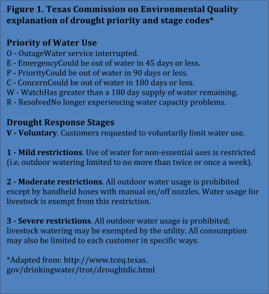
The Texas Commission on Environmental Quality, the state’s oil and gas regulatory agency, publishes a list of drought-affected public water systems and their restrictions, classifying them by “stage” and “priority” (Figure 1). Stage refers to the expected duration of the existing water supply, while priority reflects the degree to which residents’ water usage is being restricted. This means water systems with no immediate threat of their supplies expiring may be applying extreme restrictions to sustain that supply. Water systems in the highest stage of “Emergency” have at most 45 days before their water supplies are exhausted; a priority of “Severe” means the water system has forbidden all outdoor water usage and may limit individual residents’ usage if they believe it’s necessary. At the time of this writing, 442 water systems have instituted voluntary restrictions on water usage, but 44 systems have a Severe priority, and five of those are in a stage of Emergency.

Of those systems, only the White River Municipal Water District appears in the map above within the data layer of public water systems offered by the TCEQ, and it lies within 20 miles of eight different fracking wells1. According to FracFocus.org, these eight wells consumed a combined volume of almost 600,000 gallons of water, or 1.8 acre-feet, when they were first fractured. While that amount may sound low, FracFocus shows 1,557 fracking wells within the state of Texas, and White River is located about 100 miles from the major oil fields of west Texas, where individual wells commonly consumed millions of gallons of water. For eight wells combined, 600,000 gallons is at the bottom of the scale.

FracFocus also notes that these figures do not take into account the amount of fresh water used in drilling. As freshwater becomes scarcer, hydraulic fracturing operations are turning to brackish water, which contains salt or other minerals, and water recycled from previous gas wells: the TWDB estimated that 17,000 of the 81,500 acre-feet of water used in 2011 was either brackish or recycled, and water recycling specifically is on the rise ever since the Texas legislature removed the need to seek permits before recycling water on leased land. FTS International reports that some of its Texas wells have completely switched over to recycled water.

It remains to be seen how soon efforts like this will bring relief to towns like Barnhart.


Footnotes

1. The eight wells in question are Bryant B-1045, etal #4576; Bryant B-1045, etal #4578; Flores, etal #182; Rankin #etal 161; Rankin, etal #172; Wheeler-1046, #4666; Wheeler-1046, #4678; and Williams, etal #4570. Reports on all of them can be found on FracFocus by searching for Crosby County, Texas.

The awkward “k” in “fracking”

Note

This post has been archived. It is provided here for informational purposes only.

By Samantha Malone, MPH, CPH – Manager of Science and Communications, FracTracker Alliance


We are often asked why there is no “k” after “frac” in our name, FracTracker. This makes for lively conversations at parties, I assure you. Quite frankly, the etymology of the term “fracking” would make for its own interesting study, especially if you include fans of Battlestar Galactica in your research.

Truth-be-told, our name stemmed from an intense academic vs communications debate. FracTracker originally started as a project within the University of Pittsburgh. As many people in the field of know, academics are not known for brevity in the naming of projects or publications. We wanted a name that embodied both the research and community aspects of our work but was short enough to say all in one breadth. Calling such a new initiative “The Mapping of Unconventional Oil and Gas Extraction Data at the University of Pittsburgh’s Center for Healthy Environments and Communities,” while accurate, just doesn’t flow off the tongue nicely.

At the time “fracking” was a term used in some circles to refer to the entire process of extracting natural gas and oil using non-traditional methods – even though it technically only refers to the hydraulic fracturing of a well to stimulate hydrocarbon retrieval. A project partner of ours suggested the name “FrackTracker,” since we planned to track all activity related to unconventional oil and gas drilling. According to people who work in industry, however, including a “k” in the word fracking just doesn’t make sense… And rightly so; there is no “k” in the phrase hydraulic fracturing, so why should there be one in fracking? Even though fracking is now a term commonly used to discuss the industry as a whole, we still decided to omit the awkward “k” just in case.

#didntneedtoknow but #thanks


FracTracker became an independent non-profit in 2012 called FracTracker Alliance. Learn more about us >

WV Field Visits 2013

Intentional Omissions? Waterless Fracturing

Note

This post has been archived. It is provided here for informational purposes only.

By Samantha Malone, MPH, CPH – Manager of Science and Communications

We got called on it; we have no articles about waterless fracturing on FracTracker.org – yet.

Fracturing deep geologic formations to access oil and gas without the use of water offers some financial benefits; it minimizes the water-in and waste-out costs, even though the upfront costs are higher for the driller. Environmentally, this is a plus since the sites would theoretically use much less water than they currently do (~5 million gallons per well depending on who you ask). The omission of an article on FracTracker about waterless fracturing, while not intentional, does reflect the nature of our work. As data enthusiasts, we try to focus on information that can be obtained from available data. We’ve looked into but found there to be limited data regarding the actual use and productivity of waterless fracturing. As such, we have not written anything specifically about the technique to-date.

Having said that, if you, the public, know where we could access data of this nature, please let us know. We would be more than happy to analyze and discuss waterless fracturing on our site in the future.

Hydraulic fracturing for oil and natural gas can use millions of gallons of water per well. Waterless frac technology could change that.

You can learn more about waterless frac technology in an article on RigZone.com.

Chieftain Sands - Chetek WI Mine North

Sifting Through Sand Mining

Note

This post has been archived. It is provided here for informational purposes only.

By Brook Lenker and Ted Auch, FracTracker Alliance

Thirty miles northwest of Eau Claire, Wisconsin the land rolls gently. Wooded hills back orderly farms straight from the world of Norman Rockwell but painted red and gold by October’s cool brush.  It seems like agrarian perfection, but the harmony is interrupted by the pits and mounds of a newcomer to America’s Dairyland – sand extraction to support hydraulic fracturing for the oil and natural gas industry.

“Mine, Baby, Mine” reads a bumper sticker on a pickup outside the Baron drying plant of Superior Silica Sands – a frac sand company headquartered in Fort Worth, Texas but with significant activities located in Wisconsin. Ted Auch, Ohio Program Coordinator for FracTracker, and I are on a daylong sand mining tour organized by the West Central Wisconsin Regional Planning Commission (WCWRPC). This, the second Superior drying plant we visited, processes up to 2.4 million tons of sand per year (enough sand to complete 800 typical horizontal gas or oil wells). This is among the largest facilities of its kind in the world.

What is frac sand?

Frac sands (99% silicon dioxide – SiO2) are meant to “prop” open the rock after fracturing is complete, termed “proppants.” Aside from water, these sands represent the second largest constituent pumped into a typical well to hydraulically fracture the shale.  Usage of frac sand as a proppant is increasing due to the rising costs associated with synthetic substitutes like ceramic and related resin-coated materials. Ideally, such sand must be uniformly fine and spherical, crush-resistant, acid soluble, mature, and clay/silt-free. The northern Great Lakes Basin represents the primary stock for high quality frac sand in the world – causing many industry analysts to label the region Sand Arabia.

And where does it come from?

Most of Superior’s total production (4.2 million tons per year) comes from mines in New Auburn and Clinton, Wisconsin – in the middle of the St. Peter (Ottawa) Sandstone. This formation underlies parts of Iowa, Wisconsin, Minnesota, Illinois and Missouri. Known for its uniform and rounded grains – the region has recently surpassed the Hickory (Brady) formation in Texas, which contains sands that are far more angular, blocky and coarse.

To get an idea of the landscape where these sand mining operations are occurring in Wisconsin, see Figure 1 below.

Figure 1. Land cover types (%) and the location of the mines we visited during our recent frac sands tour of West Central Wisconsin (Note: 1.0 = 100%)

“Thank God for Superior Silica Sands,” said Jim Walker, Director of Operations. He wasn’t directly touting his employer’s virtues, but rather sharing a quote from a landowner pleased with the income derived from leasing their farm for the sand beneath. According to Walker, Superior has over 100,000 acres of mining leases in Wisconsin – enough to support their company’s anticipated needs for the next 30 years. Based on frac sand mine permitting data provided to us by the planning commission, this 100,000 acreage translates to 939,700,000 tons of frac sand (enough for 313,233 horizontal wells). Overall, Wisconsin’s frac sand mines are currently producing 185-211 million tons of frac sand from 128 facilities.

Superior is one of more than six sand companies working in the area. One state resident recently emailed me complaining that “we are being inundated with industrial sand mining.” Her perspective is one of concern, but we are told of farmers who are eager to lease their land for potentially hundreds of thousands of dollars in annual payments. Superior prides itself on hiring from the community. The jobs pay well, nearly twice the regional average, according to the planning commission. Healthcare benefits and a 401k are included. At quick glance, it is an economic boom to a rural region, but will it last? Superior has a 10-year contract to supply sand to Schlumberger, a giant in hydraulic fracturing services. Sand prices – affected by competition and overproduction – are dropping, however.

Sand Mining Risks

Environmental impacts may be the biggest cause for worry. Some mining operations can cover more than 450 acres and often involve the destruction of forests. This may happen piecemeal, perhaps 20 acres at a time, but forest habitat and the associated functions (e.g. carbon storage and accrual) are nevertheless diminished. The land is remediated1, but the landowner makes the decisions as to how this occurs. They might choose to plant prairie grasses or trees, but a common preference is more cropland – the latter option enabled by a post-mining reduction in topography. Adaptable wildlife like deer may take the changes in stride, but forest-dependent species and vulnerable plant communities will likely suffer. Water quality and quantity issues have also been highlighted by Wisconsin Watch, Minneapolis Star Tribune, and Minnesota Public Radio.

Public health impacts are perhaps less clear. Superior officials explain that only the finest sand sizes are a legitimate inhalation hazard, and those are atypical to the frac sand industry. A 2012 OSHA hazard alert, however, listed respirable crystalline silica as a significant workplace hazard on unconventional oil and gas well pads, just behind the risk for physical injuries and hydrogen sulfide exposure. At least at Superior, they rigorously monitor the air quality onsite and outside their boundaries. Employees are even monitored for what they breathe. Superior shows data underscoring its outstanding safety and regulatory compliance record. I observe no noticeable blowing of sand or dust on site. While I am on the ground touring, however, Ted enjoys a bird’s eye view courtesy of LightHawk. From the plane, he witnesses aerial movement of material off of other sand mines.

Emissions from increased truck traffic may also present an air quality concern. Dump trucks ply the back roads like worker ants delivering load after heavy load from the mines to the drying plants. The general increase in activity in these forgotten areas may be a lifesaver for some, and a worry for others. Trains with scores of covered, sand-packed cars rumble down the tracks bound for distant shale basins. Texas awaits the trains departing Superior’s Baron plant. Meanwhile, communities express concern about increasing speeds and the safety of crossings.

A Complicated Perspective

For me, the day’s enlightening dialogue and experiences underscore the rough, expanding tendrils of unconventional oil and gas development. They reach far and have complex, often abrasive effects. Here, in the land of Leopold, the father of the Land Ethic, I can’t help but wonder: What would Aldo say about the transformation of his beloved countryside?

View all photos from tour >


Footnotes

For additional resources and articles on sand mining issues, visit the Land Stewardship Project in Minnesota and Wisconsin Watch.

[1] Reclamation success, permitting, bond release, inspection and enforcement, and land restrictions were put into law by the Carter administration and introduced by Arizona Republican Morris Udall as defined by the Surface Mining Control and Reclamation Act of 1977, which also created the Office of Surface Mining.