Leases and Severed Rights in PA’s State Forests
A few years ago, the Department of Conservation and Natural Resources (DCNR), the agency responsible for state park and state forest lands throughout Pennsylvania, published maps on their website showing which state forest lands had been leased for the purpose of unconventional oil and gas exploration and development. Not only has that page been taken down, but the data are also not among the hundreds of Pennsylvania-specific datasets available on the Pennsylvania Spatial Data Access (PASDA), to which DCNR is a key contributor.
This data does still exist though, and it was provided to the FracTracker Alliance from DCNR upon request, along with data showing areas of the state forest where unconventional oil and gas rights are owned by the state, which is not always the case. However, this fulfillment of our data request came with some strings attached:
- I understand that the accuracy of this data set and its boundaries cannot be guaranteed and should not be considered precise.
- I will not distribute raw data to other entities outside the scope of this request.
- I will annually provide the Bureau of Forestry with a status update of the project activities and findings. If the project is abandoned, I will provide the Bureau of Forestry copies of the available information from the project.
- I will provide the Bureau of Forestry with copies of draft reports, articles, publications and so forth that result from this analysis.
- If requested, I agree to supply the Bureau of Forestry with copies of data analysis.
- I understand that the Bureau of Forestry or the Commonwealth of Pennsylvania is not relinquishing any rights or interests with this agreement.
Obviously, this ties our hands with regards to making the data available for download, either through the download section of our site, or through ArcGIS Online, but we feel as if the scope of our request was worded in such a way as to allow us to produce a map of these layers, and make that available for public viewing. Readers interested in obtaining similar data will have to contact DCNR directly, until the agency decides to release the data regarding Pennsylvania’s public lands without conditions.
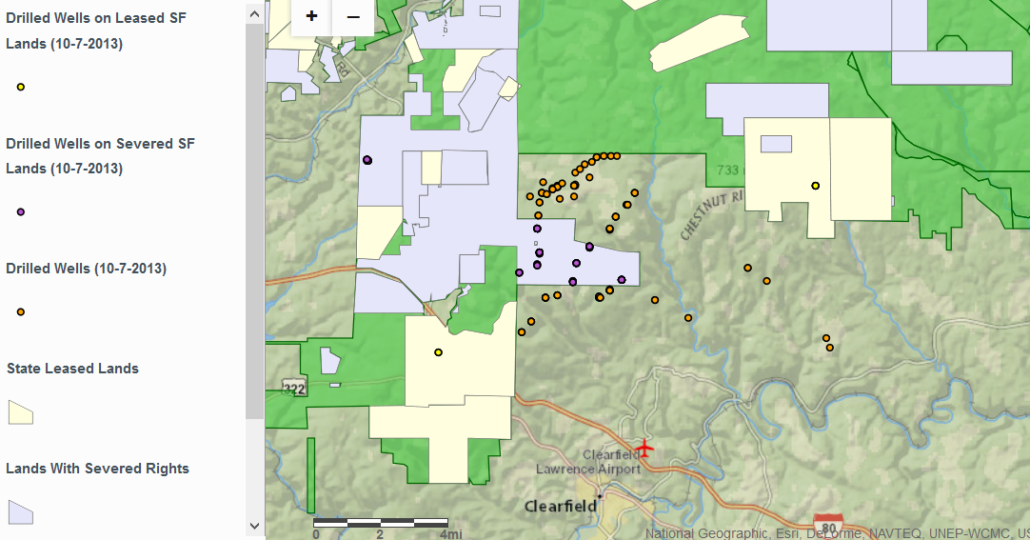
We have combined this data with drilling data from the Pennsylvania Department of Environmental Protection, so that we can finally take a closer look at drilling on public lands in Pennsylvania, including an approximation of which wells are drilled on lands have been leased by the state, and which by third parties. So with all appropriate disclaimers, here is that map:
Drilled unconventional wells in Pennsylvania and control of mineral rights on state forest land. To access full controls, such as legends, layer controls, and layer descriptions, please click the expanding arrows in the top-right corner of the map.
I don’t understand why the Commonwealth of PA thinks it can put such restrictions on public data regarding public lands. Seems to me its public information. I’m just sayin….
Note: This blog was updated on 10-10-2013 for the purpose of including the actually agreed-to stipulations by DCNR, rather than those that were originally proposed.