Maps of Updated Central Penn Pipeline Emphasize Threats to Residents and Environment
By Sierra Shamer, Guest Author
The Atlantic Sunrise Project or Central Penn Line is a natural gas pipeline Williams Companies has proposed for construction through eight counties of Central Pennsylvania. Williams intends to connect the Atlantic Sunrise to their two Transco pipelines, which extend from the northeast to the Gulf of Mexico. FracTracker discussed and mapped this controversial project as part of a blog entry in June of 2014; since then, the Atlantic Sunrise Project has been, and continues to be, a focus of unprecedented opposition. While supporters of the pipeline stress how it may enhance energy independence, economic growth, and job opportunities, opponents cite Williams’ poor safety records, their threats of eminent domain, and environmental hazards. This article provides details and maps pertaining to these threats and concerns.
Atlantic Sunrise: Project Overview
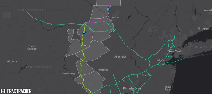
The Atlantic Sunrise Project would add 183 miles of new pipeline through the construction of the Central Penn Line North and the Central Penn Line South. The proposed Central Penn Line North (CPLN) begins in Susquehanna County, continues through Wyoming and Luzerne counties, and meets with the Transco Pipeline in Columbia County. With a 30 inch in diameter, it would allow for a maximum pressure of 1,480 psi (pounds per square inch). The proposed Central Penn Line South (CPLS) begins at the Transco Pipeline in Columbia County, and continues through Northumberland, Schuylkill, and Lebanon counties, ending in Lancaster. It would be 42 inches in diameter with a maximum pressure of 1,480 psi. The Atlantic Sunrise project also involves the construction of two new compressor stations, one in Clinton Township, Wyoming County, and the other in Orange Township, Columbia County. Finally, to accommodate the daily 1.7 million dekatherms (1 dekatherm equals 1,000 cubic feet of gas or slightly more than 1 million BTUs in energy) of additional natural gas that would flow through the system, the project proposes the expansion of 10 existing compressor stations along the Transco Pipeline in Pennsylvania, Maryland, Virginia, and North Carolina. Although the Atlantic Sunrise Pipeline would be entirely within Pennsylvania, it is permitted and regulated by the Federal Energy Regulatory Committee (FERC) because through its connection to the Transco Pipeline, it transports natural gas over state lines.
Updated Central Penn Pipeline Route
On March 31, 2015, Williams filed their formal application to FERC docket #CP15-138. Along with the formal application came changes to the pre-filing route of the pipeline that was submitted in the spring of 2014. The route of the Central Penn Line North has been modified since then by 21%, while the Central Penn Line South has been rerouted by 57%.
Williams’ application comprised of hundreds of attached documents, including pipeline alignment sheets for the entire route. Here is one example:
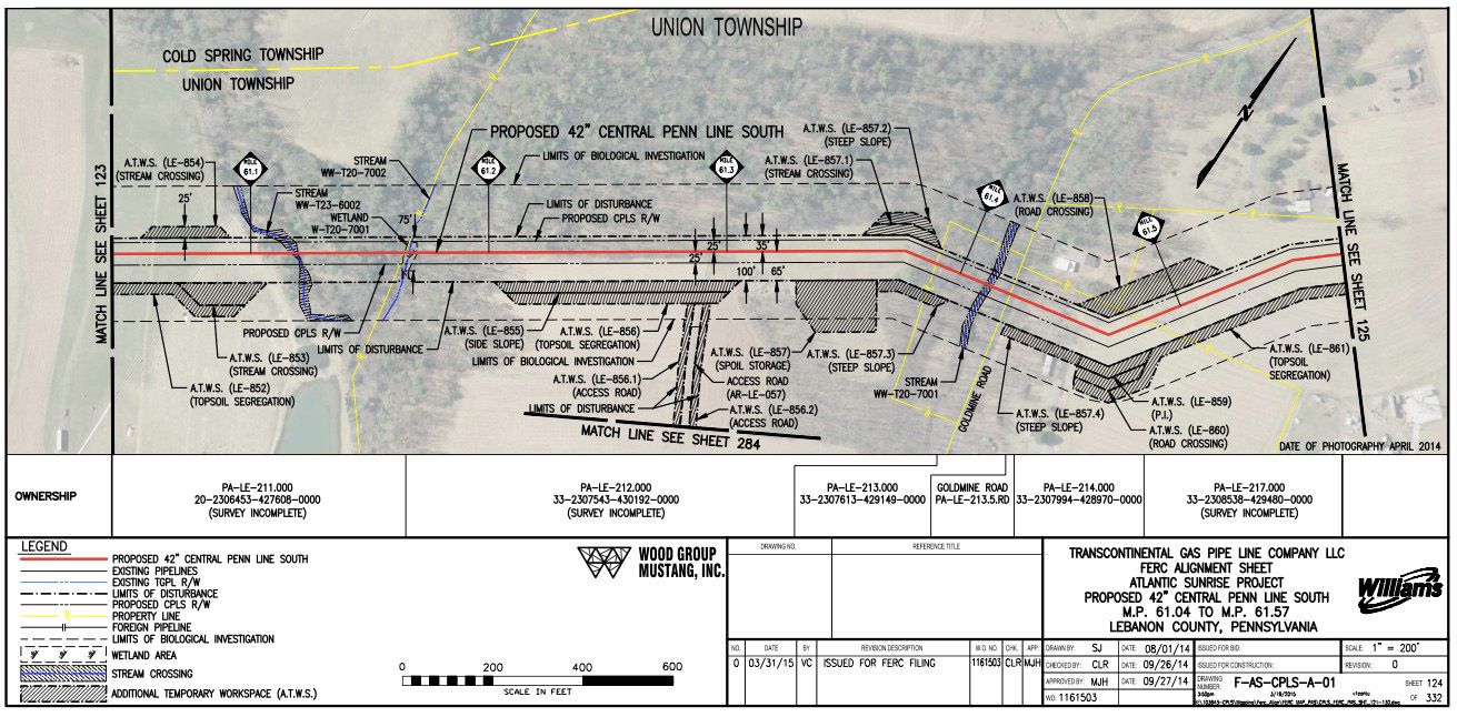
These alignment sheets show the extent of William’s biological investigation, the limits of disturbance, the occurrence of stream and wetland crossings, and any road or foreign pipeline crossings. Absent from the alignment sheets, however, is the area around the right-of-way that will be endangered by the presence of the pipeline. This is colloquially known as the “burn zone” or “hazard zone”.
What are “Hazard Zones”?
A natural gas pipeline moves flammable gas under extreme pressure, creating a risk of pipeline rupture and potential explosion. The “potential impact radius” or “hazard zone” is the approximate area within which there will be immediate damage in the case of an explosion. Should this occur, everything within the hazard zone would be incinerated and there would be virtually no chance of escape or survival. Based on pipeline diameter and pressure, the hazard zone can be calculated using the formula: potential impact radius = 0.69 * pipeline diameter * (√max pressure ).
Based on this formula, the hazard zone for the Central Penn Line North, with its diameter of 30 inches and maximum pressure of 1,480 psi, is approximately 796 feet (243 meters) on either side of the pipeline. The hazard zone for Central Penn Line South, with its diameter of 42 inches and maximum pressure of 1480 psi, is 1,115 feet (340 meters) on either side.
Many residents are unaware that their homes, workplaces, and schools are located within the hazard zone of the proposed Atlantic Sunrise Pipeline. Williams does not inform the public about this risk, primarily communicating with landowners along the right-of-way. The interactive, zoomable map (below) of the currently proposed route of the Atlantic Sunrise, Central Penn North and South pipelines depicts the pipeline right-of-way, as well as the hazard zones. The pipeline route was digitized using the alignments sheets included in Williams’ documents submitted to FERC. You can use this map to search home, work, and school addresses to see how the pipeline will affect residents’ lives and the lives of their communities.
Click in the upper right-hand corner of the map to expand to full-screen view, with a map legend.
Affected Communities
Landowners & Eminent Domain
Landowners along the right-of-way are among the most directly and most negatively impacted by the Atlantic Sunrise Pipeline, and other similar projects. Typically, people first become aware that a pipeline is intended to pass through their property when they receive a notice in the mail. Landowners faced with this news are on their own to negotiate with the company, navigate the FERC permitting and public comment process, and access unbiased and pertinent information. They face on-going stress, experiencing pressure from Williams to sign easement agreements, concern about the effects of construction on their property, and fear of living near explosive infrastructure. They must also consider costs of legal representation, decreases in property value, and limited options for mortgage and refinancing.
Sometimes, landowners in a pipeline’s right-of-way choose to not allow the company onto their property to conduct a survey. Landowners may also refuse to negotiate an agreement with the pipeline company. In response, the pipeline company can threaten to seize the property through the power of eminent domain, the federal power allowing private property to be taken if it is for the “public use.”
The law of eminent domain states that landowners whose properties are condemned must be fairly compensated for their loss. However, most landowners feel that in order to be fairly compensated by the company, they must hire their own land appraiser and attorney. This decision can be costly, however, and may not be an option for many people. The legitimacy of Williams’ intent to use eminent domain is contested by opponents of the project, who cite how “public use” of the property provides no positive local impacts. The Atlantic Sunrise Pipeline is intended to transport gas out of Pennsylvania through the Transco, so the landowners in its path will not benefit from it at all. Further, it connects to a network of pipelines leading to current export terminals in the Gulf of Mexico, as well as controversial planned export facilities like Cove Point, MD .
Throughout Pennsylvania, communities have responded to the expansion of pipelines, and to the threats of large companies like Williams. The need for landowner support has been addressed by organizations such as the Shalefield Organizing Committee, Energy Justice Network, the Clean Air Council, the Gas Drilling Awareness Coalition, and We Are Lancaster County. These organizations have worked to provide information, increase public awareness, engage with FERC, and develop resistance to the exploitation of Pennsylvania’s resources and residents. Director Scott Cannon of the Gas Drilling Awareness Coalition has documented firsthand the impacts of unconventional drilling in Pennsylvania through a short film series called the Marcellus Shale Reality Tour. The most recent in the series relates the stories of two landowners impacted by the Atlantic Sunrise Pipeline in the short film Atlantic Sunrise Surprise.
Environmental Review
Theoretically, environmental review of this proposed pipeline would be extensive. Primary decision-making on the future of the Atlantic Sunrise rests with FERC. Due to the National Environmental Policy Act of 1969 (NEPA), all projects overseen by federal agencies are required to prepare environmental assessments (EAs) or environmental impact assessments (EIAs). Because FERC regulates interstate pipelines, EA’s or EIA’s are required in their approval process. These assessments are conducted to accurately assess the environmental impacts of projects and to ensure that the proposals comply with federal environmental laws such as the Endangered Species Act, and the Clean Air and Water Acts. On the state level, the Pennsylvania Department of Environmental Protection (PA DEP) issues permits for wetlands and waterways crossings and for compressor stations on regional basis.
Core Habitats, Supporting Landscapes
The route of the Atlantic Sunrise Pipeline will disturb numerous areas of ecological importance, including many documented in the County Natural Heritage Inventory (CNHI). The PA Department of Conservation and Natural Resources conducted the inventory to be used as a planning, economic, and infrastructural development tool, intending to avoid the destruction of habitats and species of concern. The following four maps show the CNHI landscapes affected by the current route of the Atlantic Sunrise pipeline (Figures 1-4).
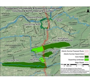
Figure 1. Columbia & Northumberland counties
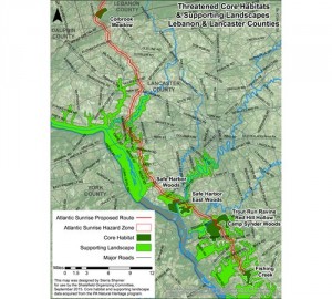
Figure 2. Lebanon & Lancaster counties
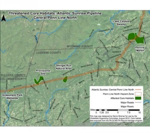
Figure 3. Threatened Core Habitats
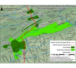
Figure 4. Schuyklill & Lebanon counties
The proposed pipeline would disrupt core habitats, supporting landscapes, and provisional species-of-concern sites. According to the Natural Heritage Inventory report, core habitats “contain plant or animal species of state or federal concern, exemplary natural communities, or exceptional native diversity.” The inventory notes that the species in these habitats will be significantly impacted by disturbance activities. Supporting landscapes are defined as areas that “maintain vital ecological processes or habitat for sensitive natural features.” Finally, the provisional species of concern sites are regions where species have been identified outside of core habitat and are in the process of being evaluated. The Atlantic Sunrise intersects 16 core habitats, 12 supporting landscapes, and 6 provisional sites.
Active Mine Fires

Figure 5. Glen Burn Mine Fires
The current route of the Atlantic Sunrise intersects the Cameron/Glen Burn Colliery, considered to be the largest man-made mountain in the world and composed entirely of waste coal. This site also includes a network of abandoned mines, three of which are actively burning (Figure 5).
The pipeline right-of-way is roughly a half-mile from the closest burning mine, Hickory Swamp. These mine fire data were sourced from a 1988 report by GAI Consulting Inc. The time frame for the spread of the mine fires is unknown, and dependent on environmental factors. Mine subsidence — when voids in the earth created by mines cause the surface of the earth to collapse — is another issue of concern. Routing the pipeline through this unstable area adds to the risk of constructing the pipeline through the Glen Burn region.
Looking Ahead
The Atlantic Sunrise Project has received an unprecedented level of resistance that continues to grow as awareness and information about the threats and hazards develops. While Williams, FERC, and the PA DEP negotiate applications and permits, work is also being done by many non-profit, research, and grassroots organizations to investigate the environmental, cultural, and social costs of this pipeline. We will follow up with more information about this project as it becomes available.
This article was written by Sierra Shamer, an environmental mapper and activist. Sierra is a member of the Shalefield Organizing Committee and holds two degrees from the University of Maryland, Baltimore County: a B.A. in environmental studies and an M.S. in geography and environmental systems.