
In 2013, the Pennsylvania Supreme Court significantly shifted the role of citizens and the state in creating local zoning ordinances with its landmark decision in Robinson Township v. Commonwealth of Pennsylvania. The court struck down parts of Pennsylvania’s Act 13 that imposed statewide zoning standards for oil and gas development and invalidated the legislature’s attempt to override the right of municipalities to designate where these uses could occur. The court did so on the basis that municipalities not only had a right, but a duty to protect citizens’ rights “to clean air, pure water, and to the preservation of natural, scenic, historic and esthetic values of the environment” under Article I, Sections 1 and 27 of the Pennsylvania Constitution.
Zoning ordinances with stronger protections for the health and safety of citizens are now being adopted by townships and boroughs across the state. However, despite clear mandates from the courts, many other townships and boroughs are left with rules that reflect the now illegal pre-Robinson language, which allows mineral extraction everywhere, regardless of whether it is a compatible land use. Some of these ordinances were passed after Act 13. In this article, FracTracker Alliance worked with Mountain Watershed Association to map zoning ordinances in Southwestern Pennsylvania relative to oil and gas infrastructure in order to reveal development trends, potential vulnerabilities, and to encourage greater public participation in local zoning.
Changes to PA Zoning Laws
With the 2013 Robinson Township v. Commonwealth of Pennsylvania decision, the Pennsylvania Supreme Court struck down parts of Pennsylvania’s Act 13 that imposed statewide zoning standards for oil and gas development and invalidated the legislature’s attempt to require municipalities to allow gas development in all zoning districts. A plurality of judges did so, in part, on the basis that municipalities have a duty to protect citizen’s rights under Article 1, Section 27 of the Pennsylvania Constitution. This article established a public trust over Pennsylvania’s public natural resources for the benefit of both current and future generations. A concurring justice and en banc panel of Commonwealth Court judges found that Act 13 violated Article I, Section 1, which protects citizens’ substantive due process rights. In these decisions, the concurring Justice and the Commonwealth Court determined that Act 13 made zoning irrational, by placing incompatible industrial uses in areas set aside under the zoning scheme for non-industrial activity.
Map of Zoning Ordinances
This interactive map contains zoning information for 666 townships and boroughs located in 12 Southwestern Pennsylvania counties: Allegheny, Beaver, Butler, Cambria, Fayette, Greene, Indiana, Lawrence, Mercer, Somerset, Washington, and Westmoreland. For each of these government entities we have included, where available, information on local and county zoning laws, comprehensive plans, oil & gas specific ordinances, and contact information. The locations of unconventional gas wells, well permits, and well violations are also shown on the map. Additional layers that can be activated include pipelines routes, mined areas, public schools, and hospitals in the region.
Zoning information for this article was compiled from online searches of county and municipal websites by staff at Mountain Watershed Association (MWA). Mapping and analysis was conducted by FracTracker Alliance.
Summaries & Analysis
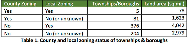
In compiling the zoning ordinance map, we discovered a number of interesting trends. Only 3 counties have county-wide zoning ordinances (Greene, Fayette, and Indiana). Table 1 summarized the number of townships and boroughs relative to county and local zoning. We found that nearly 35% of all land area in the 12 county study has no zoning of any kind.
Zoning Relative to Oil & Gas Wells
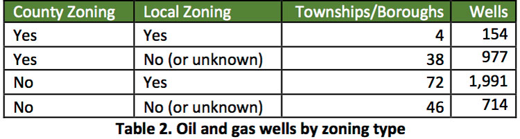
Of 3,836 unconventional oil and gas wells in the 12 counties, we found that 1,131 (29%) wells were in counties with zoning compared to 2,705 (71%) wells in counties without zoning. In other words, wells are nearly 2.5 times more likely to be located in counties without zoning.
We expected to find that most development would also occur where there was no local zoning. However, to our surprise, only a small fraction (19%) of wells were found to be in townships and boroughs with no county or local zoning of any kind (see Table 2). This could indicate that, even though municipalities have enacted zoning, the enacted ordinances may lack protective language to guard against the harms of oil and gas development. This is where education becomes crucial. Providing municipal leadership with materials showing the potential risks involved in oil and gas development is a necessary first step.
A list of the top 10 townships and boroughs, ordered by number of wells, is shown in Table 3.

Zoning Relative to Well Permits
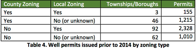
Of 7,469 unconventional well permits in the 12 counties, we found that 4,708 permits were issued prior to 1/1/2014 (table 4). This date was selected as a reference point for permits issued after changes to Act 13.
1,370 (30%) of these permits were in counties with zoning compared to 3,338 (70%) in counties without zoning.
2,483 (53%) of these permits were in townships and boroughs with local zoning compared to 2,225 (47%) in those without local zoning.
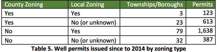
After 1/1/2014, we found that 2,761 new permits have been issued in the 12 counties (table 5).
736 (26.6%) of these new well permits are in counties with zoning compared to 2,025 (73.4%) permits in counties without zoning.
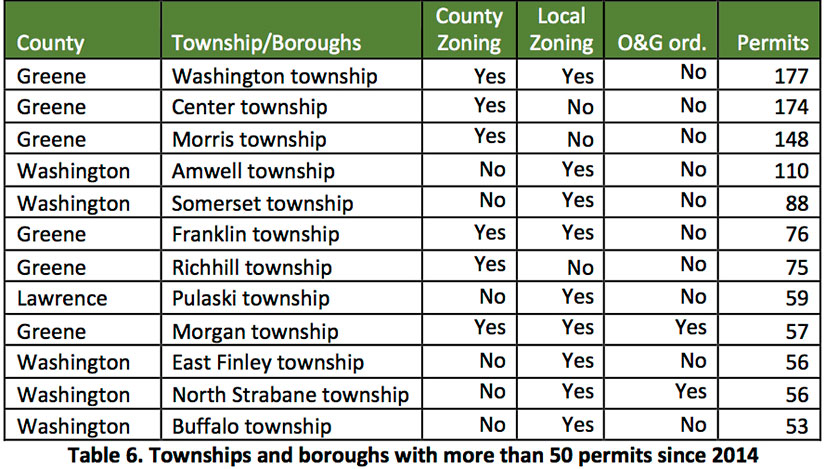
1,761 (64%) of these permits were in townships and boroughs with local zoning compared to 1,000 (36%) in those without local zoning. Of townships and boroughs with more than 50 permits, only 2 have local oil and gas ordinances in place (table 6).
Our analysis suggests that, overall, more oil and gas development tends to take place in counties without zoning ordinances. However, the low percentage of townships and boroughs that have no zoning of any kind relative to their number of wells (19%) suggests that other important local variables at play besides zoning restrictions. Industry operators could be choosing to focus their development in areas where infrastructure already exists (i.e., roads, pipelines, processors), where wells tend to be most productive, or where residents and elected officials have accepted the industry’s presence.
The differences in where permits are being issued since 2014 raises additional questions. While counties with zoning are seeing proportionally fewer permits issued within their borders, townships and boroughs with local zoning are actually seeing proportionally more permits. However, one trend in our analysis is that heavily drilled areas tend to have no local oil and gas ordinance as part of their zoning regulations. This finding may provide additional insight in future investigations.
Finally, the analysis done for this article covers only 12 of the many counties in Pennsylvania experiencing unconventional oil and gas development. While this study begins to show some of the relationship between zoning and oil and gas buildout, it is likely that these trends would become clearer by expanding our study to other counties.
Conclusions
Zoning, both at the county and local level, remains one of the most important tools communities have at their disposal when shaping the course of oil and gas development. We believe that the impacts of local zoning on development are just now beginning to have an effect as townships and boroughs are revisiting and updating legacy ordinances to control oil and gas development within their borders. One example of how this is being done can be found in recent changes to zoning rules made by officials of Penn Hills and Churchill in Allegheny County.
The map produced in our study makes it easy for people to find zoning resources that exist in their area, as well as to assess their level of risk for future oil and gas development. For more excellent resources from our partner organizations, visit Halt the Harm Network to access their leadership directory network and to see a preview of MWA’s Citizen’s Response Guide to Zoning. Also check out Protect Our Children’s ABC’s: A Guide to Protecting Our Schools and Communities from Shale Gas Development to learn how to safeguard vulnerable populations from extractive industry.
Mountain Watershed Association is a non-profit organization dedicated to protecting, preserving and restoring the Indian Creek and greater Youghiogheny River watersheds. Through their Marcellus Citizen Stewardship Project, MWA advocates for tighter regulations on shale gas development while using state and federal laws to ensure communities and our water are protected.
Mapping and analysis for this article was conducted by Kirk Jalbert, PhD, MFA – Manager of Community-Based Research & Engagement, FracTracker Alliance.