The Falcon: Class Locations, Buildings & Recreational Areas
Part of the Falcon Public EIA Project
In this segment of the Falcon Public EIA Project we begin to explore the different ways that pipelines are assessed for potential risk to populated areas. We outline a methods dictated by the Pipeline and Hazardous Materials Safety Administration (PHMSA) called Class Locations. This methods identifies occupied structures in proximity to a pipeline.
Quick Falcon Facts
The following map will serve as our guide in breaking down the Falcon’s Class Locations. Expand the map full-screen to explore its contents in greater depth. Some layers only become visible as you zoom in. A number of additional layers are not shown by default, but can be turned on in the “layers” tab. Click the “details” tab in full-screen mode to read how the different layers were created.Map of Falcon Class Locations
View Map Fullscreen | How FracTracker Maps Work
Pipeline Class Locations
Pipeline “Class locations” determine certain aspects of how a pipeline is constructed. Essentially, a pipeline’s route is segmented into lengths that are each given different classifications as outlined in PHMSA guidelines. In general terms, a segment’s Class is established by first calculating a buffer that extends 220 yards (660ft) on either side of the pipeline’s center in 1-mile continuous lengths. This buffer area is then analyzed for how many building structures are present. Classes are then assigned to each 1-mile segment using the follow criteria:
- Class 1: a segment with 10 or fewer buildings intended for human occupancy
- Class 2: a segment with more than 10, but less than 46 buildings intended for human occupancy
- Class 3: a segment with 46 or more buildings intended for human occupancy, or where the pipeline lies within 100 yards of any building, or small well-defined outside area occupied by 20 or more people on at least 5 days a week for 10 weeks in any 12-month period (i.e. schools, businesses, recreation areas, churches)
- Class 4: a segment where buildings with four or more stories aboveground are prevalent
The finer details of these calculations and their adjustments are complex, however. For instance, Class locations can be shortened to less than 1-mile lengths if building densities change dramatically in an certain area. The example image below shows one of the ways available to operators for doing this, called the “continuous sliding” method:

Class location designations may also be adjusted over time as densities change. For instance, if new homes were built in proximity to a previously constructed pipeline, the operator may be required to reduce their operating pressure, strengthen the pipeline, or conduct pressure tests to ensure the segment would technically meet the requirements of a higher Class. Alternatively, operators can apply for a special permit to avoid such changes.
What Class Locations Dictate
Pipeline segments with higher Classes must meet more rigorous safety standards, which are enforced either by PHMSA or by their state equivalent, such as the Pennsylvania Utility Commission. These include:
- Soil depth: Class 1 locations must be installed with a minimum soil depth of 30 inches (18 inches in consolidated rock). Class 2, 3, and 4 locations require a minimum soil depth of 36 inches (24 inches in consolidated rock)
- Shut-off valves: Class locations determine the maximum distance from shut-off valves to populated areas, as follows: Class 1 (10 miles), Class 2 (7.5 miles), Class 3 (4 miles), and Class 4 (2.5 miles).
- Operating pressure: Classes also regulate the maximum allowable operating pressure (MAOP) of pipeline segments
- Structural integrity: Classes determine where thicker walled materials must be used to withstand higher pressures, as well as different structural testing methods used in safety inspections
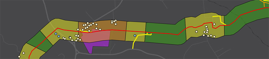
By replicating the 600 foot buffer from the Falcon’s centerline (used as the standard distance for determining Class Locations) we found that 67% of the Falcon route will qualify as Class 1, 27% as Class 2, and 3% as Class 3. These are represented on our interactive maps as green, yellow, and orange segments, respectively. An additional segment is marked as having an “unknown” Class on our maps (shaded in gray). This is the stretch crossing the Ohio River, where Shell’s Class location analysis has not been updated to reflect the route change that occurred in the summer of 2017.
Residential Structures
![]() In total, there are 557 single family residences, 20 businesses, and a church within the 660ft buffer. Shell’s data also identify non-occupied structures along the route, such as sheds, garages, and other outbuildings. There are 535 such structures, but we did not have the time to replicate the locations of these sites. It is also important to note that the points on our interactive map represent only those identified by Shell, which we believe is an incomplete assessment of occupied structures based on our quick review of satellite maps.
In total, there are 557 single family residences, 20 businesses, and a church within the 660ft buffer. Shell’s data also identify non-occupied structures along the route, such as sheds, garages, and other outbuildings. There are 535 such structures, but we did not have the time to replicate the locations of these sites. It is also important to note that the points on our interactive map represent only those identified by Shell, which we believe is an incomplete assessment of occupied structures based on our quick review of satellite maps.
Three residential structures lie directly within the 50-foot right-of-way. One of these homes, located in a Class 2 segment in Independence Township, is shown below. The Falcon will come as close as 20 feet to the edge of the structure and surround the home on three sides.

Neighborhoods in the following five communities account for the entirety of Falcon’s Class 3 locations. These would be considered the most “at risk” areas along the route in terms of proximity to the number of occupied structures. For instance, below is a satellite view of the Class 3 section of Raccoon Township.
- Rumley Township, Harrison OH
- Knox Township, Jefferson County OH
- Raccoon Township, Beaver County PA
- Independence Township, Beaver County PA
- Mount Pleasant Township, Washington County PA

Recreational Areas
In the above image we also see the location of Raccoon Township Municipal Park (in purple), home to a number of ballfields. Two similar recreation areas are located in the 660ft Class Location buffer: Mill Creek Ballpark, in Beaver County PA, and Clinton Community Park, in Allegheny County PA.
However, the Raccoon Township park is notable in that the Falcon cuts directly through its property boundary. Shell intends to bore under the park using HDD techniques, as stated in their permit applications, “to avoid disturbance to Beaver County baseball field/recreational park,” also stating that, “this HDD may be removed if the recreational group will allow laying the pipeline along the entrance roadway.”
New Housing Developments
![]() One discovery worth attention is that the Falcon runs straight through an under-construction luxury housing development. Located in Allegheny County, PA, its developer, Maronda Homes, bills this growing community as having “picturesque landscapes, waterfront views and a peaceful collection of homes.” Shell mentions this development in their permit applications, stating:
One discovery worth attention is that the Falcon runs straight through an under-construction luxury housing development. Located in Allegheny County, PA, its developer, Maronda Homes, bills this growing community as having “picturesque landscapes, waterfront views and a peaceful collection of homes.” Shell mentions this development in their permit applications, stating:
Maronda Homes is in the planning and design stage of a very large housing development and SPLC [Shell Pipeline LC] worked closely with the developer and the Project was rerouted to avoid most of the housing sites.
It stands to reason that this neighborhood will eventually rank as one of the densest Class 3 areas along the Falcon route. Whether or not the pipeline is updated with higher safety standards as a result remains to be seen. The image below illustrates where the Falcon will go relative to lots marked for new homes. This property lots diagram was obtained from Shell’s GIS data layer and can be viewed on the FracTracker interactive map as well.

![]() 1/31/18 Note: the Pittsburg Post-Gazette obtained newer lot line records for a portion of the Maronda Farms during their investigation into this story. These new records appear to have some alterations to the development, as seen below.
1/31/18 Note: the Pittsburg Post-Gazette obtained newer lot line records for a portion of the Maronda Farms during their investigation into this story. These new records appear to have some alterations to the development, as seen below.

Issues with Setbacks
There are no setback restrictions for building new homes in proximity to a pipeline. Parcels will eventually be sectioned off and sold to home buyers, begging the question of whether or not people in this community will realize a hazardous liquid pipeline runs past their driveways and backyards. This is a dilemma that residents in a similar development in Firestone, Colorado, are now grappling with following a recent pipeline explosion that killed two people, seen below, due to inadequate building setbacks.

Interestingly, we researched these same Maronda Farms parcels in FracTracker’s Allegheny County Lease Mapping Project only to discover that Maronda Homes also auctioned off their mineral rights for future oil and gas drilling. New homeowners would become victims of split-estate, where drilling companies can explore for oil and gas without having to seek permission from property owners, amplifying their level of risk.
* * *