Well Pad Violations in Pennsylvania
Emerging Trends
We are always learning new things at FracTracker. While we have been analyzing and mapping oil and gas (O&G) violations issued by the Department of Environmental Protection (DEP) in Pennsylvania since 2010, we have apparently been under-representing the total amount of issues associated with unconventional drilling in the state.
The reason for the missing violations is that there are inconsistencies with how well pads are classified in the compliance report. Many of these well pads – full of unconventional permits and drilled wells – are indeed categorized as “unconventional” in the DEP compliance data. Others, equally full of unconventional permits and wells, simply leave that field blank.
Therefore, any analysis for unconventional violations is likely to miss some of the incidents that are attributed to the well pad itself, as opposed to any of the wells that are found upon that well pad.
Midas Well Pad unearths issue
While we have heard about missing violation data in the past, I discovered the nature of the issue while researching the Midas Well Pad in Plum Borough, Allegheny County on the DEP resource site eFACTS, noting the presence of multiple violations at the nascent well site. However, when attempting to download the relevant data on the compliance report, the results were missing. I had entered search parameters that made sense to me, limiting results to violations in the proper county and municipality, and including an inspection date range that was broader than what was showing up on eFACTS. I had also limited results to unconventional wells, because while this is Plum’s first unconventional well pad, the back roads are dotted with dozens – if not hundreds – of conventional O&G sites.
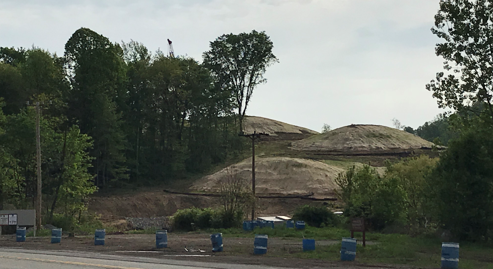
The Midas Well Pad, as seem from Coxcomb Hill Rd. in Plum, PA
After that attempt failed, I downloaded the entire state’s worth of data, whether conventional or not, and I was able to find the 31 violations associated with the well pad.
I contacted DEP about this, wondering whether there was some data irregularity that prevented my search in Plum from finding all of the incidents that occurred there. The reply was somewhat helpful, noting that there was no county, municipality, or unconventional value associated with that well pad in the compliance report, explaining why the search result came up negative.
It is worth noting that the separate well pad report does indeed have values for all of these fields for the Midas Well Pad, so there is a lack of consistency on this issue. Even more importantly, it is worth remembering that any compliance report search that limits results using county, municipality, or unconventional variables are likely to result in incomplete results.
The violations at the Midas Well Pad are focused around erosion and sedimentation issues, wetland impacts, failure to follow approved methodology, and failure to fix some of the problems on subsequent site inspections. The compliance report includes a narrative inspection comment, giving the public a glimpse through the inspector’s eyes. Here is one of several such comments at the site:
Follow up inspection related to wetland impact reported on 2/23/18 and 2/24/18. At the time of inspection, the Operator was actively conducting earth disturbance activity associated with the construction of well pad channel 6. The Department gave verbal permission on 2/27/2018 to deviate from the construction sequence and continue with the construction of PCSM wet pond 1. At the time of inspection wet pond 1 was partially constructed. The outlet structure and emergency spillway associated with wet pond 1. At the time of inspection wet pond 1 was holding water, however the slopes were not temporary stabilized. The Operator indicated that additional work was planned for the wet pond and would be temporary stabilized. The Operator indicated a previously unidentified seep located upgradient and outside of the LOD is contributing additional water to wet pond 1. The Department recommended the Operator identify wet weather springs upgradient from wet pond 1. Additionally, the Department recommends the Operator monitor all additional flow and submit a permit modification outlines changes made to the construction sequence and identifies the location of all toe drains to be constructed on site. The Department and Operator agreed to reschedule an onsite meeting to discuss the remediation of the wetland. Th Department recommends the Operator monitor the vegetative growth in the wetland. The Department recommends that the Operator add additional temporary mulch to the disturbed area and continue to perform routine maintenance to the temporary BMPs.
How pervasive is this problem?
The DEP well pad report contains data on 12,600 wells, situated on 3,715 wells pads. On the compliance side, there are 2,689 violations at 390 different sites that contain the words “Well Pad.” 739 of these violations do not have associated Well API Numbers, and are therefore not shown in our Pennsylvania Shale Viewer map. The number of sites with violations per operator is shown below in Figure 1 (click to expand).
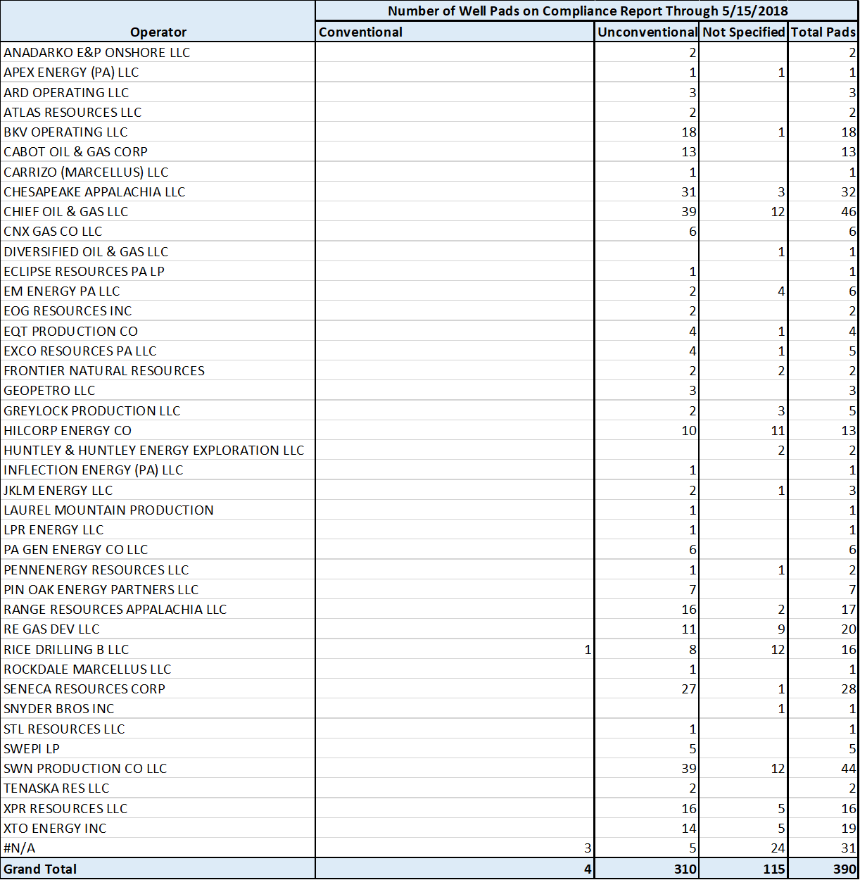
Figure 1: Number of well pads appearing on compliance report by operator, through 5/15/2018. Click on the image to see the full-sized version.
There are four things to note about about Figure 1.
First, this table is not the number of violations on well pads, but merely the count of well pads with violations appearing on the compliance report.
Second, this does not contain any data on wells on those pads that were issued violations – only instances where the well pads themselves were cited are shown.
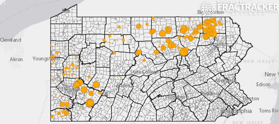
PA Well Pad Violations:
This map shows oil and gas (O&G) violations in Pennsylvania that are assessed to well pads, as opposed to individual wells. To access the map’s legend and other details, click the double-arrow icon at the top-left corner of the map.
The third thing to note about Figure 1 is that there are instances where the same pad falls into more than one category. Hilcorp Energy, for example, has 10 wells in the unconventional category, 11 wells that are not defined, but only 13 total wells, indicating significant overlap between the categories.
And fourth, there are 31 instances where the phrase “well pad” occurs in the compliance report where the unique Site ID# does not appear on the well pad report. In some cases, the name of the facility indicates that it might be for another facility that is related to the well pad, such as “Southwest System – Well Pad 36 to Bluestone Pipeline.” For other entries, such as “Yarasavage Well Pad”, it remains unclear why the Site ID# does not yield a matching entry from the well pad report.
By Matt Kelso, Manager of Data and Technology, FracTracker Alliance