Mapping Gathering Lines in Ohio and West Virginia
As a spring 2020 intern with FracTracker, my work mostly involved mapping gathering lines in West Virginia and Ohio. Gathering lines are pipelines that transport oil and gas from the wellhead to either compressor stations or storage/processing facilities. The transmission pipelines (which are often larger in diameter than gathering lines) take the oil and gas from the processing facilities to other storage facilities/compressor stations, or to distribution pipelines which go to end users and consumers. As you can see from Figure 2 in the map of Doddridge County, WV, many gathering lines eventually converge at a compressor station. You can think of gathering lines like small brooks and streams that feed transmission pipelines. The transmission lines are the main arteries, like a river, moving larger quantities of gas and oil over longer distances.
PROJECT DESCRIPTION
The main project and goal of my internship was to record as many gathering pipelines as I could find in Ohio and West Virginia, since gathering lines are not generally mapped and therefore not easily available for the public to view. For example, the National Pipeline Mapping System’s public map viewer (created by the Department of Transportation Pipeline and Hazardous Materials Safety Administration) has a note stating, “It does not contain gas gathering or distribution pipelines.” Mapping gathering lines makes this data accessible to the public and will allow us to see the bigger picture when it comes to assessing the environmental impact of pipelines.
After collecting gathering line location data, I performed GIS analysis to determine the amount of acreage of land that has been clearcut due to gathering pipeline installations.
Another analysis we could perform using this data is to count the total number of waterways that the gathering lines cross/interact with and assess the quality of water and wildlife in areas with higher concentrations of gathering pipelines.

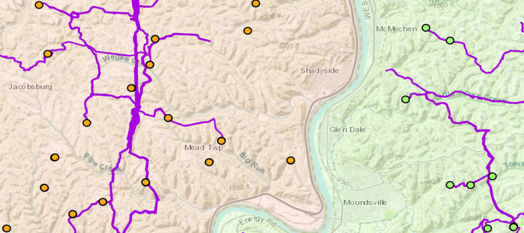
Figure 1. This map shows an overview of gathering line pipelines in the Powhatan Point, Ohio and Moundsville, West Virginia of the Ohio River Valley.
PIPELINE GATHERING LINE MAPPING PROCESS
I worked with an aerial imagery BaseMap layer (a BaseMap is the bottommost layer when viewing a map), a county boundaries layer, production well location points, and compressor station location points. I then traced lines on the earth that appeared to be gathering lines by creating polygon shapefiles in the GIS application ArcMap.
My methodology and process of finding the actual routes of the gathering lines included examining locations at various map scale ranges to find emerging line patterns of barren land that connect different production well points on the map. I would either concentrate on looking for patterns along well pad location points and look for paths that may connect those points, or I would begin at the nearest gathering line I had recorded to try to find off-shoot paths off of those pipelines that may connect to a well pad, compressor station or previously recorded gathering line.
I did run into a few problems during my search for gathering lines. Sometimes, I would begin to trace a gathering line path, only to either loose the path entirely, or on further inspection, find that it was a power line path. Other times when using the aerial imagery basemap, the gathering line would flow into an aerial photo from a year prior to the pipeline installation and I would again lose the path. To work around these issues, I would first follow the gathering line trail to its end point before I started tracing the path. I would also view the path very closely in various scale ranges to ensure I wasn’t tracing a road, waterway, or powerline pathway.
ACREAGE ANALYSIS
In the three months that I was working on recording gathering pipeline paths in Ohio and West Virginia, I found approximately 29,103 acres (3,494 miles) of barren land clearcut by gathering pipelines. These total amounts are not exact since not all gathering lines can be confirmed. There are still more gathering lines to be recorded in both Ohio and West Virginia, but these figures give the reader an idea of the land disturbance caused by gathering lines, as shown in Figures 1 and 2.
In Ohio, I recorded approximately 10,083 acres (641 miles) with the average individual gathering pipeline taking up about 45 acres of land. With my gathering line data and data previously recorded by FracTracker, I found that there are 28,490 acres (1,690 miles) of land spanning 9 counties in southeastern Ohio that have been cleared and used by gathering lines.
For West Virginia, I was able to record approximately 19,020 acres (1,547 miles) of gathering lines, with the average gathering line taking up about 48 acres of space each. With previous data recorded in West Virginia by FracTracker, the total we have so far for the state is 22,897 acres (1,804 miles), although that is only accounting for the 9 counties in northern West Virginia that are recorded.
Figure 2. This aerial view map shows connecting gathering line pipelines that cover a small portion of Doddridge County, WV.
CONCLUSION
I was shocked to see how many gathering lines there are in these rural areas. Not only are they very prevalent in these less populated communities, but it was surprising to see how concentrated and close together they tend to be. When most people think of pipelines, they think of the big transmission pipeline paths that cross multiple states and are unaware of how much land that the infrastructure of these gathering pipelines also take up.
It was also very eye-opening to find that there are at least 29,000 acres of land in Ohio and West Virginia that were clearcut for the installation of gathering lines. It is even more shocking that these gathering pipelines are not being recorded or mapped and that this data is not publicly available from the National Pipeline Mapping System. While driving through these areas you may only see one or two pipelines briefly from your car, but by viewing the land from a bird’s eye perspective, you get a sense of the scale of this massive network. While the transmission pipeline arteries tend to be bigger, the veins of gathering lines displace a large amount of land as well.
I was also surprised by the sheer number of gathering lines I found that crossed waterways, rivers, and streams. During this project, it wasn’t unusual at all to follow a gathering line path that would cross water multiple times. In the future, I would be interested to look at the number of times these gathering pipelines cross paths with a stream or river, and the impact that this has on water quality and surrounding environment. I hope to continue to record gathering lines in Ohio and West Virginia, as well as Pennsylvania, so that we may learn more about this infrastructure and the impact it may have on the environment.
About Me
I first heard of FracTracker three years ago when I was volunteering with an environmental group called Keep Wayne Wild in Ohio. Since learning about FracTracker, I have been impressed with their eye-opening projects and their ability to make the gas and oil industry more transparent. A few years after first hearing about FracTracker, and as my interest in the GIS field continued to grow, I began taking GIS classes and reached out to them for this internship opportunity.
By Trevor Oatts, FracTracker Spring 2020 Data & GIS Intern