A New, Extensive Platform for Fracking Imagery
by Ted Auch, FracTracker Great Lakes Program Coordinator, and Rebecca Johnson, Communications & Administrative Specialist
FracTracker is pleased to release our improved multimedia platform of fracking imagery for your convenient use. You can easily view, download, and share photos and videos of oil, gas, and petrochemical impacts. We’ve made it easy for you to find what you need within over 1,600 photos, GIFs, and videos of the various aspects of fossil fuel industries and activities. All media are free to download and use for all visitors, and the collection will only expand as our work continues!
“The aeroplane has unveiled for us the true face of the earth.” by French writer and aviator Antoine de Saint-Exupéry author of Le Petit Prince (The Little Prince)
Ted Auch, FracTracker Great Lakes Program Coordinator:
It was nearly five years ago on a beautiful Wednesday morning that I met Paul Feezel, a concerned citizen of Carroll County, Ohio, and Cleveland Museum of Natural History’s David Beach at the Carroll County-Tolson Airport (40.5616667, -81.0780833). The occasion was a flight with pilot Mike Stich to see what the Fracking Boom had done to Carroll and neighboring counties.
The aspect of the industry that I came away from that flight most worried about was the hundreds of miles of pipelines we saw connecting well pad to well pad and meandering on downstream to processing facilities. These pipelines took such circuitous routes between pads that everyone in the plane was scratching their heads, wondering how such routes made any financial sense for the operators to get their raw product to market.
Ever since that flight, I have spent a significant chunk of my time at FracTracker mapping the extent of these so-called gas “gathering pipelines” across Ohio, West Virginia, and Pennsylvania. I remain as flummoxed as I was on that day how such a hastily laid and poorly regulated network of pipelines makes sense. More recently, I have been wondering what the cumulative impact of these non-FERC-regulated pipelines has been on forests, wetlands, and the remaining agriculture in the region.
We have flown over this area several more times since that initial flight, with pilots volunteering their time to navigate planes provided by our excellent partners at LightHawk. As I wrote a little over two years ago:
“… you can’t really understand or appreciate the enormity, heterogeneity, and complexity of the unconventional oil and gas industry’s impact unless you look at the landscape from the cockpit of a Cessna 172. This vantage point allows you to see the grandeur and nuance of all things beautiful and humbling. Conversely, and unfortunately more to the point of what I’ve seen in the last year, a Cessna allows one to really absorb the extent, degree, and intensity of all things destructive. I’ve had the opportunity to hop on board the planes of some amazing pilots, like Dave Warner, a forester formerly of Shanks, West Virginia … Tim Jacobson, Esq., out of La Crosse, Wisconsin, northern Illinois retired commodity and tree farmer Doug Harford, and Target corporate jet pilot Fred Muskol, out of the Twin Cities area of Minnesota.”
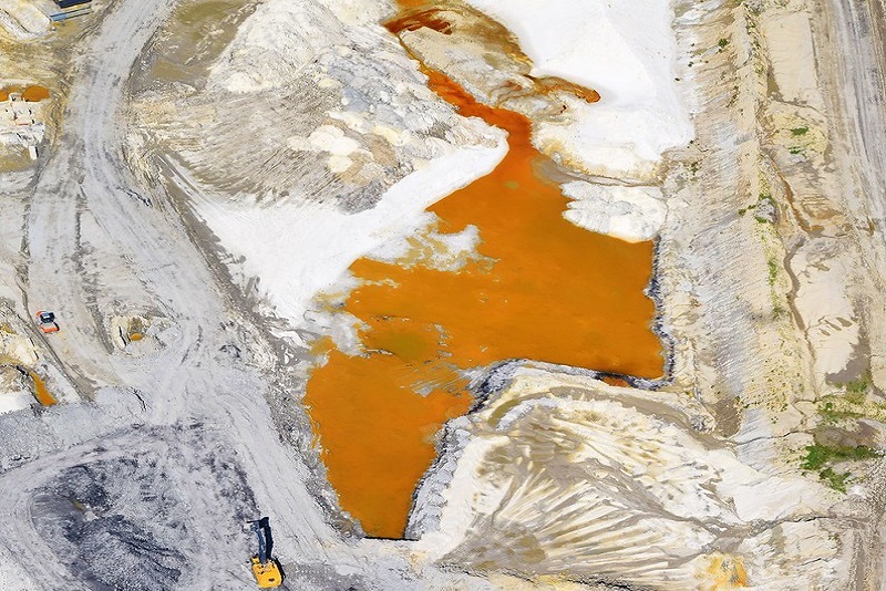
Frac sand mine impoundment pond in Wedron, IL, 2018. Photo by Ted Auch, with aerial assistance from Lighthawk.
I wrote the “Bird’s-Eye-View” piece in August 2018, and since then we’ve made additional flights with our LightHawk partners, including a harrowing flight over Pine Creek State Park in Pennsylvania last May, part of our “Wilderness Lost” digital atlas series that now includes a similar project for the adjoining Loyalsock Creek.
The May 2019 flight was exhilarating to say the least – and thanks to the skills of our pilot Steve Kent, we executed the flight and extracted some powerful imagery that was three months later appended during better flying conditions with pilot Bob Keller. This flight was notable because the cloud ceiling was around 2,400 feet, and some peaks we were flying over and around were in excess of 1,200 feet, which gave us very little room to maneuver, at times forcing us to fly down into valleys to avoid the clouds. This flight also was a great opportunity for me and Steve to practice our communication, given that we were flying so low and slow, which meant that Steve would basically give me a ten-second slot to open my window, lean out, and shoot, while he was banking around the site of interest. Unlike other flights – including the subsequent flight in the Pine Creek – we did not have any opportunities to fly around infrastructure more than once, given how volatile the cloud ceiling was, and that if there was an opening that would allow us to move laterally, we had to take it.
Between our Pine Creek flights and that initial Carroll County aerial tour, we’ve compiled literally thousands of high-quality and illustrative images of the Hydraulic Fracturing Industrial Complex. When we say “hydraulic fracturing” – or “fracking” – we are not simply referring to drill rigs and frack pads, like the industry would limit us to in our analysis, but rather all manner of activities and infrastructure, to include drill rigs and pads – but also pipelines, waste disposal sites, processing plants, and frac sand mining activities, from the aforementioned forests of northeastern Pennsylvania, to Texas’ Gulf Coast. To this point, several authors have used our imagery, such as Paul Bogard and Tom Pearson, the Proceedings of the National Academy of Sciences (PNAS), Yale Environment 360, Oil Change International, the Anthropology Magazine SAPIENS, etc.
Since COVID-19 brought everything to a halt, my colleague Rebecca Johnson and I have been working to organize these images, migrating our older and more cumbersome inventory to the image and video hosting website Flickr, where we could more appropriately catalog, group, and map these images.
Please make use of this resource and keep fighting for a more just energy future.
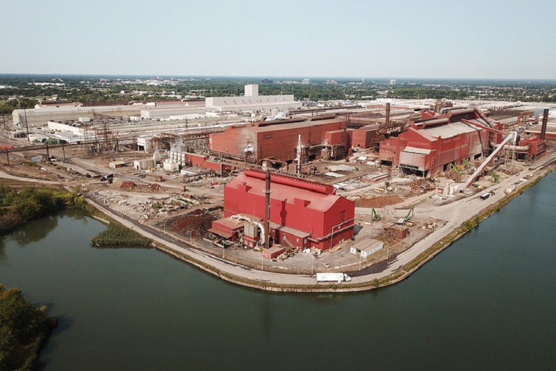
Steel plants in Detroit, MI. Photo by Ted Auch, FracTracker Alliance, with aerial assistance from Lighthawk.
Rebecca Johnson, Communications & Administrative Specialist
I began working with FracTracker in May 2019, coming in with a new and relatively limited perspective on the energy landscape, compared to Ted’s, my partner in this undertaking, who has spent years – from the ground and from above – capturing this expansion, its degradation, and the challenges it presents. After seeing the collection of Ted’s and others’ pictures on our website, I knew we needed to amplify our efforts in graphic documentation, in order for more people to see and feel what we are collectively up against.
This task was not taken lightly. FracTracker’s imagery backlog was daunting, to say the least. I scrolled through countless pictures and videos of different aspects of fossil fuel infrastructure and activity until my eyes glazed over. I had no idea the extent of the industry landscape and its effects – and so I had no idea where to even begin. The collection was immense, but the need to get more eyes on these revealing depictions was even bigger.
How was best to expose and illuminate the extensive buildout of and degradation from these resource-intensive, extractive industries?
Cataloguing began with the frac sand industry, and I slowly pieced together the breadth and depth of resource extraction. The aerial snapshots and panoramic captures of enormous mines, immense sand piles, and vast, sandy, slurry ponds connected by looming conveyors and miles of train tracks created a twisting path through my mind, traversing the various stages of extraction to production, through landscapes wrought with reckless human consumption. But frac sand is only one starting point in the onslaught, is only an upstream activity that sets the stage for further ruin downstream, with oil and gas extraction, petrochemical and plastic production, and various types of pollution and erroneous waste disposal from all these activities – not to mention the waste and pollution following human consumption, when we think we are “done” with a material.
As I sifted through images, the dots started connecting, and what started as a simple list of subjects quickly became an outline of what our country’s communities and environment were up against. Navigating through the picture hoard, Ted and I regularly discussed the people he had met while capturing these shots.
He spoke of friends he has made along the way – people in communities that had endured this buildout, seeing their lands chipped away, their natural corridors disconnected, and their waterways depleted or entirely consumed to make room for more industrial sites. It had compelled some of them to leave their homes, and some were even forced to abandon their sacred lands, left only with the lasting, heartbreaking memory of seeing it sullied beyond recognition and repair.
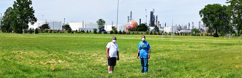
Detroit residents Doug Wood and Theresa Landrum stand in front of a Marathon Oil refinery in southwest Detroit, MI, 2020. Photo by Ted Auch, FracTracker Alliance.
This realization lead to our stepwise sorting of imagery by these industries and activities to include the impacts and hazards to communities, culture, and livelihoods, already endured, happening currently, and looming ominously in the future. It’s easy to see the negative alterations from a bird’s-eye view, with the tainted landscape laid out below, punctured by ugly facilities and marred by indiscriminate ruin. It is another, more emotional thing to connect these scenes to those living in them, to the livelihoods dissolved and the generational homes displaced. Farmers have seen their lands infringed upon, their soils tainted and their waters poisoned. Communities have witnessed their air quality deteriorate, their children and friends fall sick, and their neighborhoods empty, at the expense of these industries. An often-overlooked aspect of extraction is those who bear its initial ramifications in their own communities.
At this point, we’ve winnowed our vast trove of imagery down to over 1,600 images across 46 albums. After weeding through this extensive catalog to identify our most powerful snapshots, we thought it would be appropriate to present the first iteration of this over five-month project to our audience and collaborators, with the hopes of better informing/illustrating your work.
With our migration to Flickr, I hope more eyes find this imagery, explore our collections, and follow the connections from album to album, to better understand the effects of fossil fuel activities. Whether it is the withered landscapes, the depleted environments, or the fragmented lives that speak to the viewer most, it is important to remember what has been endured to procure these resources, and what it will take to move to a cleaner, more just energy landscape.
In the event some of you were not aware of certain aspects of the industry, please take this opportunity to tour these albums and familiarize yourself with the myriad infrastructure and impacts of fracking.
Navigate to the Collections page to see FracTracker’s imagery convey a story through the albums grouped there – such as exploring the buildout through the Infrastructure & Transportation Collection, or the Plastics & Petrochemicals Collection. Visit the Albums page to see snapshots sorted by specific types of facilities, like Frac Sand Mining and Pipelines, or by specific projects, like Endless Effects: the Loyalsock Creek Watershed Project. Once you click on a photo, you can view its location on a map.
A primary source of inspiration for this aerial photography endeavor is the late Bill Hughes out of Wetzel County, West Virginia, who left us in March 2019. Bill was a force of nature in West Virginia’s documentation, with his camera and local know-how, the fracking industry’s negligence, and the fact that they seemed to run roughshod over his beloved state’s beautiful landscape. As our Executive Director Brook Lenker wrote following Bill’s death:
“Just taking pictures was not enough. Context was needed. Bill interpreted each picture – explaining the location, thing or activity, and significance of every image. Did it represent a threat to our water, air, or land? When did it happen? What happened before and after? Did it show a short- or long-term problem? Should state regulatory agencies see it to become better informed? Dissemination followed in many forms: tours of the gas fields; power point presentations to groups in five states; op-ed pieces written for news media; countless responses to questions and inquiries; even blogs and photo essays for various websites. Ceaseless Bill never stopped caring. Maybe Bill Hughes should be an official emblem for Earth Day – a humble, faithful man of modest proportions, spreading the stewardship imperative from a little electric car. Hitch a ride, follow his lead, and, like Bill, always tell it like it is.”
We hope that our work in the air and on the ground photographing industry impacts would make Bill proud. We will continuously update these Flickr albums, and offer as much background and locational data as possible to facilitate an unsurpassed level of depth and breadth for all users.
Additional Readings:
Lenker, B. “An Earth Day Tribute to Bill Hughes”, April 22nd, 2019, https://fractracker.org/2019/04/earth-day-tribute-bill-hughes/
Auch, T. “Documenting Fracking Impacts: A Yearlong Tour from a Bird’s-Eye-View”, August 8th, 2018, https://fractracker.org/2018/08/birds-eye-view-fracking/
FracTracker and Earthworks “Endless Effects: A Digital Atlas Exploring the Environmental Impacts of a Decade of Unconventional Natural Gas Extraction in the Loyalsock Creek Watershed”, August, 2020, https://fractracker.org/projects/the-loyalsock-watershed-project/
FracTracker and Earthworks “Wildness Lost: A Digital Atlas Examining Over a Decade of Unconventional Natural Gas Development in Pennsylvania’s Pine Creek Watershed”, August, 2019, https://fractracker.org/projects/wildness-lost-pine-creek/
Auch, T. “Fracking Threatens Ohio’s Captina Creek Watershed”, December, 2109, https://fractracker.org/2019/12/fracking-in-captina-creek-watershed-story-map/
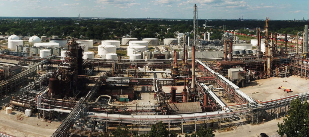
Feature photo of a Toledo Refining Company refinery in Toledo, OH, July, 2019. Photo by Ted Auch, FracTracker Alliance.