Tag Archive for: Gulf of Mexico

Colonial Pipeline and site of Sept 2016 leak in Alabama

A Proper Picture of the Colonial Pipeline’s Past

On September 9, 2016 a pipeline leak was detected from the Colonial Pipeline by a mine inspector in Shelby County, Alabama. It is estimated to have spilled ~336,000 gallons of gasoline, resulting in the shutdown of a major part of America’s gasoline distribution system. As such, we thought it timely to provide some data and a map on the Colonial Pipeline Project.

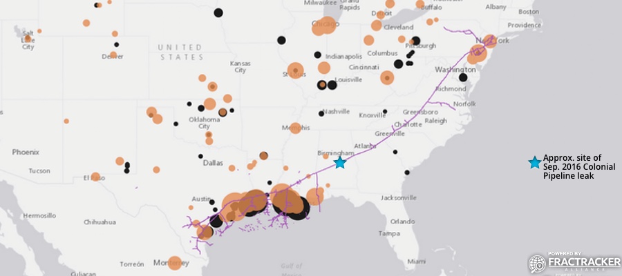
Figure 1. Dynamic map of Colonial Pipeline route and related infrastructure

View Map Fullscreen | How Our Maps Work | The Sept. 2016 leak occurred in Shelby County, Alabama

Pipeline History

The Colonial Pipeline was built in 1963, with some segments dating back to at least 1954. Colonial carries gasoline and other refined petroleum projects throughout the South and Eastern U.S. – originating at Houston, Texas and terminating at the Port of New York and New Jersey. This ~5,000-mile pipeline travels through 12 states and the Gulf of Mexico at one point. According to available data, prior to the September 2016 incident for which the cause is still not known, roughly 113,382 gallons had been released from the Colonial Pipeline in 125 separate incidents since 2010 (Table 1).

Table 1. Reported Colonial Pipeline incident impacts by state, between 3/24/10 and 7/25/16

State Incidents (#) Barrels* Released Total Cost ($)
AL 10 91.49 2,718,683
GA 11 132.38 1,283,406
LA 23 86.05 1,002,379
MD 6 4.43 27,862
MS 6 27.36 299,738
NC 15 382.76 3,453,298
NJ 7 7.81 255,124
NY 2 27.71 88,426
PA 1 0.88 28,075
SC 9 1639.26 4,779,536
TN 2 90.2 1,326,300
TX 19 74.34 1,398,513
VA 14 134.89 15,153,471
Total** 125 2699.56 31,814,811
*1 Barrel = 42 U.S. Gallons

** The total amount of petroleum products spilled from the Colonial Pipeline in this time frame equates to roughly 113,382 gallons. This figure does not include the September 2016 spill of ~336,000 gallons.

Data source: PHMSA

Unfortunately, the Colonial Pipeline has also been the source of South Carolina’s largest pipeline spill. The incident occurred in 1996 near Fork Shoals, South Carolina and spilled nearly 1 million gallons of fuel into the Reedy River. The September 2016 spill has not reached any major waterways or protected ecological areas, to-date.

Additional Details

Owners of the pipeline include Koch Industries, South Korea’s National Pension Service and Kohlberg Kravis Roberts, Caisse de dépôt et placement du Québec, Royal Dutch Shell, and Industry Funds Management.

For more details about the Colonial Pipeline, see Table 2.

Table 2. Specifications of the Colonial and/or Intercontinental pipeline

Pipeline Segments 1,1118
Mileage (mi.)
Avg. Length 4.3
Max. Length 206
Total Length 4,774
Segment Flow Direction (# Segments)
Null 657
East 33
North 59
Northeast 202
Northwest 68
South 20
Southeast 30
Southwest 14
West 35
Segment Bi-Directional (# Segments)
Null 643
No 429
Yes 46
Segment Location
State Number Total Mileage Avg. Mileage Long Avg. PSI Avg. Diameter (in.)
Alabama 11 782 71 206 794 35
Georgia 8 266 33 75 772 27
Gulf of Mexico 437 522 1.2 77 50 1.4
Louisiana 189 737 3.9 27 413 11
Maryland 11 68 6.2 9 781 30
Mississippi 63 56 0.9 15 784 29
North Carolina 13 146 11.2 23 812 27
New Jersey 65 314 4.8 28 785 28
New York 2 6.4 3.2 6.4 800 26
Pennsylvania 72 415 5.8 17 925 22
South Carolina 6 119 19.9 55 783 28
Texas 209 1,004 4.8 33 429 10
Virginia 32 340 10.6 22 795 27
PSI = Pounds per square inch (pressure)

Data source: US EIA


By Sam Rubright, Ted Auch, and Matt Kelso – FracTracker Alliance

Map of pipelines, platforms, and active oil and gas leases in the Gulf of Mexico

Latest Oil and Gas Incident in the Gulf of Mexico

By Karen Edelstein, NY Program Coordinator

The extent of offshore drilling for oil and gas in the Gulf of Mexico is nothing short of staggering. According to the US National Oceanic and Atmospheric Administration (NOAA), there are more than 3,000 active wells in the federally-regulated waters of the western and central Gulf. Additionally,  there are over 25,000 miles of active oil and gas pipelines crisscrossing the Gulf of Mexico sea floor, and more than 18,000 miles of “out of service” pipeline there. To wit, NOAA’s 2012 State of the Coast website boasts, “If placed end to end, the oil and gas pipelines in the Gulf of Mexico could wrap around the Earth’s equator.”

Oil and Gas Infrastructure in the Gulf of Mexico

With such a level of activity, it is difficult to envision how all of this intricate infrastructure fits together, especially in the event of a disaster. There is a dire need to access and visualize such data as more and more wells are drilled unconventionally – both onshore and off. Below is a map of oil and gas drilling platforms both historical and active, pipelines, and active leases in the Gulf of Mexico.

For a full-screen view of this map, with a legend, click here.

The Worst Environmental Incident in US History

Deepwater Horizon drilling platform explosion (April 2010)

Deepwater Horizon drilling explosion (April 2010)

The April 2010 BP “Deepwater Horizon” blow-out disaster stands out as one of the icons of environmental risks that such intensive oil and gas production can pose to our oceans. The rig was set in over 4,000 feet of water, and close to 6 miles into the sea floor. A blowout occurs when pressurized oil or gas, mud, and water cannot be contained by the well’s blowout preventer. These materials blast through the drill pipe to the surface. There, no longer under pressure, they expand and ignite. Human or mechanical and design errors are at fault the majority of the time. Such was the case with the Macondo Deepwater Horizon disaster, now the worst offshore environmental disaster in US history.

Heavily oiled brown pelicans wait to be cleaned of Gulf spill crude

Heavily oiled brown pelicans wait to be cleaned

In all, more than 200 million gallons of oil flowed into the ocean before the Deepwater Horizon well could be plugged. Eleven workers died, and 17 were injured. The Center for Biological Diversity estimates that 82,000 birds, 6000 sea turtles, and nearly 26,000 marine mammals were impacted as a result of this spill.

Penn State University reported actual animal deaths as 6,104 birds, 609 sea turtles, and 100 marine mammals. More than 1,000 miles of shoreline were fouled. Furthermore, as part of the process of breaking up the spill with chemical dispersants, more than 2 million gallons of toxic chemicals were sprayed into the Gulf. The long-term impacts of these dispersants on marine wildlife have yet to be determined.

Other Oil & Gas Exploration Accidents of Note

Natural gas spills also happen with some frequency in the Gulf, but they are considerably different from oil rig blow-outs. Unlike the persistence of oil in the marine environment, gas leaks are dissolved readily into the sea water, and once on the surface, quickly evaporate. Methane-eating bacteria in the water also help in the process. In July 2013, a rig 55 miles offshore, in 154 feet of water in the Gulf off the Louisiana coast, exploded and caught fire. The blaze went out of control and partially destroyed the rig. There was a thin sheen of hydrocarbons on the ocean surface initially, but it dissipated rapidly. A relief well was drilled, and the leak contained. While the effects on marine life may not be tremendous, the release of this amount of carbon to the seawater and atmosphere is yet another stress to global warming, moving us closer by the day to the tipping point of climate disaster.

Unfortunately, these types of leaks and explosions happen with regularity. A maintenance-related explosion happened in September 2011 in the Gulf, 100 miles off the Louisiana coast. All 13 crew on the platform were forced to jump for safety into the water, where they were later rescued. Fortunately, there were no deaths in this case. In September 2014, however, during maintenance at a Chevron natural gas pipeline off the Louisiana coast, one contractor was killed and two injured in another incident.

And Most Recently…

And just last week, on November 20, 2014, there was another report of yet one more Gulf of Mexico oil platform explosion, 12 miles off the coast. This time, one worker was killed and three injured at an explosion at Fieldwood Energy’s Echo Platform. The employees were cleaning a piece of equipment when the blast occurred.

According to news reports, the Bureau of Safety and Environmental Enforcement related, “The Echo Platform was not in production at the time of the incident,” BSEE said in a statement Thursday. “The facility damage was limited to the explosion area and there was no pollution reported.”

Both the September and November incidents are under investigation.

________

GIS datasets for this post originated from the US Bureau of Ocean Energy Management. Learn more

For information on offshore oil and gas exploration in California and the associated danger and regulations, read the October 20, 2013 Fractracker blog entry Hydraulic Fracturing Offshore Wells on the California Coast, by FracTracker’s California staffer Kyle Ferrar.