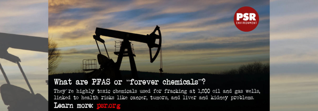
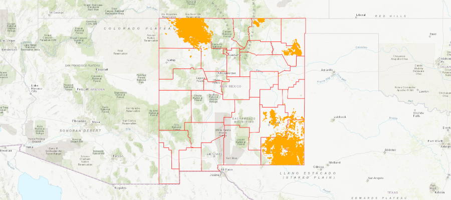
A new report released by Physicians for Social Responsibility (PSR) in April 2023 reveals that oil and gas companies have been using PFAS, a class of extremely toxic and persistent chemicals, in New Mexico since at least 2013.
https://www.fractracker.org/a5ej20sjfwe/wp-content/uploads/2023/04/DSC_0855.jpg10011500FracTracker Alliancehttps://www.fractracker.org/a5ej20sjfwe/wp-content/uploads/2025/09/2025-Wordmark-Logo.pngFracTracker Alliance2023-04-27 13:46:002023-04-27 14:18:17Evidence Shows Oil and Gas Companies Use PFAS in New Mexico Wells
FracTracker Alliance released a new map identifying the locations of over 1,200 oil and gas wells using toxic “forever chemicals” in Arkansas, Louisiana, Oklahoma, New Mexico, Texas, and Wyoming.
FracTracker Alliance has released a new national map, filled with energy and petrochemical data. Explore the map, continue reading to learn more, and see how your state measures up!
This map has been updated since this blog post was originally published, and therefore statistics and figures below may no longer correspond with the map
The items on the map (followed by facility count in parenthesis) include:
For oil and gas wells, view FracTracker’s state maps.
Transportation & Storage
Natural gas compressor stations (1,367) – Facilities built along a pipeline route that pressurize natural gas to keep it flowing through the pipeline.
Crude oil rail terminals (94) – Rail terminals that load and unload crude oil (liquid hydrocarbons that have yet to be processed into higher-value petroleum products).
Liquefied natural gas import/export terminals (8) – Facilities that can a) liquefy natural gas so it can be exported as LNG (liquefied natural gas) and/or b) re-gasify LNG so it can be used as natural gas. Natural gas is transported in a liquid state because it takes up less space as a liquid than as a gas.
Natural Gas Underground Storage (486) – Locations where natural gas is stored underground in aquifers, depleted gas fields, and salt formations.
Petroleum Product Terminals (1,484) – Terminals with a storage capacity of 50,000 barrels or more and/or the ability to receive volumes from tanker, barge, or pipeline. Petroleum products include products “produced from the processing of crude oil and other liquids at petroleum refineries, from extraction of liquid hydrocarbons at natural gas processing plants, and from production of finished petroleum products at blending facilities.”
Petroleum Ports (242) – A port that can import and/or export 200,000 or more short tons of petroleum products a year.
Natural gas import/export pipeline facility (54) – A facility where natural gas crosses the border of the continental United States.
Pipelines
Crude oil pipelines – major crude oil pipelines, including interstate truck lines and selected intrastate lines, but not including gathering lines.
Natural gas liquid pipelines – Also referred to as hydrocarbon gas liquid pipelines, they carry the heavier components of the natural gas stream which are liquid under intense pressure and extreme cold, but gas in normal conditions.
Natural gas pipelines– Interstate and intrastate natural gas pipelines. Due to the immensity of this pipeline network and lack of available data, this pipeline layer in particular varies in degree of accuracy.
Petroleum Product Pipelines – Major petroleum product pipelines.
Recent Pipeline Projects – Pipeline projects that have been announced since 2017. This includes projects in various stages, including under construction, complete, planned or canceled. Click on the pipeline for the status.
Processing & Downstream
Natural Gas Processing Plants (478) – Plants that separate impurities and components of the natural gas stream.
Chemical plants (36) – Includes two types of chemical plants – petrochemical production and ammonia manufacturing – that report to EPA’s Greenhouse Gas Reporting Program.
Ethylene Crackers (30) – Also referred to as ethane crackers, these petrochemical complexes that converts ethane (a natural gas liquid) into ethylene. Ethylene is used to make products like polyethylene plastic.
Petroleum Refineries (135) – A plant that processes crude oil into products like petroleum naphtha, diesel fuel, and gasoline.
Power Plants (9,414) – Electric generating plants with a capacity of at least one megawatt, sorted by energy source.
Wind Turbines (63,003) – Zoom in on wind power plants to see this legend item appear.
Natural Resources
Shale Plays (45) – Tight oil and gas shale plays, which are formations where oil and gas can be extracted.
Major Rivers
Solar Energy Potential – Potential solar energy generation, in kilowatt-hours per square meter per day – averaged annually.
This map is by no means exhaustive, but is exhausting. It takes a lot of infrastructure to meet the energy demands from industries, transportation, residents, and businesses – and the vast majority of these facilities are powered by fossil fuels. What can we learn about the state of our national energy ecosystem from visualizing this infrastructure? And with increasing urgency to decarbonize within the next one to three decades, how close are we to completely reengineering the way we make energy?
Key Takeaways
Natural gas accounts for 44% of electricity generation in the United States – more than any other source. Despite that, the cost per megawatt hour of electricity for renewable energy power plants is now cheaper than that of natural gas power plants.
The state generating the largest amount of solar energy is California, while wind energy is Texas. The state with the greatest relative solar energy is not technically a state – it’s D.C., where 18% of electricity generation is from solar, closely followed by Nevada at 17%. Iowa leads the country in relative wind energy production, at 45%.
The state generating the most amount of energy from both natural gas and coal is Texas. Relatively, West Virginia has the greatest reliance on coal for electricity (85%), and Rhode Island has the greatest percentage of natural gas (92%).
With 28% of total U.S. energy consumption for transportation, many of the refineries, crude oil and petroleum product pipelines, and terminals on this map are dedicated towards gasoline, diesel, and other fuel production.
Petrochemical production, which is expected to account for over a third of global oil demand growth by 2030, takes the form of chemical plants, ethylene crackers, and natural gas liquid pipelines on this map, largely concentrated in the Gulf Coast.
Electricity generation
The “power plant” legend item on this map contains facilities with an electric generating capacity of at least one megawatt, and includes independent power producers, electric utilities, commercial plants, and industrial plants. What does this data reveal?
In terms of the raw number of power plants – solar plants tops the list, with 2,916 facilities, followed by natural gas at 1,747.
In terms of megawatts of electricity generated, the picture is much different – with natural gas supplying the highest percentage of electricity (44%), much more than the second place source, which is coal at 21%, and far more than solar, which generates only 3% (Figure 1).
Figure 1. Electricity generation by source in the United States, 2019. Data from EIA.
This difference speaks to the decentralized nature of the solar industry, with more facilities producing less energy. At a glance, this may seem less efficient and more costly than the natural gas alternative, which has fewer plants producing more energy. But in reality, each of these natural gas plants depend on thousands of fracked wells – and they’re anything but efficient.
The cost per megawatt hour of electricity for a renewable energy power plants is now cheaper than that of fracked gas power plants. A report by the Rocky Mountain Institute, found “even as clean energy costs continue to fall, utilities and other investors have announced plans for over $70 billion in new gas-fired power plant construction through 2025. RMI research finds that 90% of this proposed capacity is more costly than equivalent [clean energy portfolios, which consist of wind, solar, and energy storage technologies] and, if those plants are built anyway, they would be uneconomic to continue operating in 2035.”
The economics side with renewables – but with solar, wind, geothermal comprising only 12% of the energy pie, and hydropower at 7%, do renewables have the capacity to meet the nation’s energy needs? Yes! Even the Energy Information Administration, a notorious skeptic of renewable energy’s potential, forecasted renewables would beat out natural gas in terms of electricity generation by 2050 in their 2020 Annual Energy Outlook.
This prediction doesn’t take into account any future legislation limiting fossil fuel infrastructure. A ban on fracking or policies under a Green New Deal could push renewables into the lead much sooner than 2050.
In a void of national leadership on the transition to cleaner energy, a few states have bolstered their renewable portfolio.
Figure 2. Electricity generation state-wide by source, 2019. Data from EIA.
One final factor to consider – the pie pieces on these state charts aren’t weighted equally, with some states’ capacity to generate electricity far greater than others. The top five electricity producers are Texas, California, Florida, Pennsylvania, and Illinois.
Transportation
In 2018, approximately 28% of total U.S. energy consumption was for transportation. To understand the scale of infrastructure that serves this sector, it’s helpful to click on the petroleum refineries, crude oil rail terminals, and crude oil pipelines on the map.
Transportation Fuel Infrastructure. Data from EIA.
The majority of gasoline we use in our cars in the US is produced domestically. Crude oil from wells goes to refineries to be processed into products like diesel fuel and gasoline. Gasoline is taken by pipelines, tanker, rail, or barge to storage terminals (add the “petroleum product terminal” and “petroleum product pipelines” legend items), and then by truck to be further processed and delivered to gas stations.
China leads the world in this movement. In 2018, just over half of the world’s electric vehicles sales occurred in China. Analysts predict that the country’s oil demand will peak in the next five years thanks to battery-powered vehicles and high-speed rail.
In the United States, the percentage of electric vehicles on the road is small but growing quickly. Tax credits and incentives will be important for encouraging this transition. Almost half of the country’s electric vehicle sales are in California, where incentives are added to the federal tax credit. California also has a “Zero Emission Vehicle” program, requiring electric vehicles to comprise a certain percentage of sales.
We can’t ignore where electric vehicles are sourcing their power – and for that we must go back up to the electricity generation section. If you’re charging your car in a state powered mainly by fossil fuels (as many are), then the electricity is still tied to fossil fuels.
Petrochemicals
Many of the oil and gas infrastructure on the map doesn’t go towards energy at all, but rather aids in manufacturing petrochemicals – the basis of products like plastic, fertilizer, solvents, detergents, and resins.
Natural gas processing plants separate components of the natural gas stream to extract natural gas liquids like ethane and propane – which are transported through the natural gas liquid pipelines. These natural gas liquids are key building blocks of the petrochemical industry.
Ethane crackers process natural gas liquids into polyethylene – the most common type of plastic.
The chemical plants on this map include petrochemical production plants and ammonia manufacturing. Ammonia, which is used in fertilizer production, is one of the top synthetic chemicals produced in the world, and most of it comes from steam reforming natural gas.
As we discuss ways to decarbonize the country, petrochemicals must be a major focus of our efforts. That’s because petrochemicals are expected to account for over a third of global oil demand growth by 2030 and nearly half of demand growth by 2050 – thanks largely to an increase in plastic production. The International Energy Agency calls petrochemicals a “blind spot” in the global energy debate.
Petrochemical development off the coast of Texas, November 2019. Photo by Ted Auch, aerial support provided by LightHawk.
Investing in plastic manufacturing is the fossil fuel industry’s strategy to remain relevant in a renewable energy world. As such, we can’t break up with fossil fuels without also giving up our reliance on plastic. Legislation like the Break Free From Plastic Pollution Act get to the heart of this issue, by pausing construction of new ethane crackers, ensuring the power of local governments to enact plastic bans, and phasing out certain single-use products.
“The greatest industrial challenge the world has ever faced”
Mapped out, this web of fossil fuel infrastructure seems like a permanent grid locking us into a carbon-intensive future. But even more overwhelming than the ubiquity of fossil fuels in the US is how quickly this infrastructure has all been built. Everything on this map was constructed since Industrial Revolution, and the vast majority in the last century (Figure 3) – an inch on the mile-long timeline of human civilization.
Figure 3. Global Fossil Fuel Consumption. Data from Vaclav Smil (2017)
In fact, over half of the carbon from burning fossil fuels has been released in the last 30 years. As David Wallace Wells writes in The Uninhabitable Earth, “we have done as much damage to the fate of the planet and its ability to sustain human life and civilization since Al Gore published his first book on climate than in all the centuries—all the millennia—that came before.”
What will this map look like in the next 30 years?
A recent report on the global economics of the oil industry states, “To phase out petroleum products (and fossil fuels in general), the entire global industrial ecosystem will need to be reengineered, retooled and fundamentally rebuilt…This will be perhaps the greatest industrial challenge the world has ever faced historically.”
Is it possible to build a decentralized energy grid, generated by a diverse array of renewable, local, natural resources and backed up by battery power? Could all communities have the opportunity to control their energy through member-owned cooperatives instead of profit-thirsty corporations? Could microgrids improve the resiliency of our system in the face of increasingly intense natural disasters and ensure power in remote regions? Could hydrogen provide power for energy-intensive industries like steel and iron production? Could high speed rail, electric vehicles, a robust public transportation network and bike-able cities negate the need for gasoline and diesel? Could traditional methods of farming reduce our dependency on oil and gas-based fertilizers? Could zero waste cities stop our reliance on single-use plastic?
Of course! Technology evolves at lightning speed. Thirty years ago we didn’t know what fracking was and we didn’t have smart phones. The greater challenge lies in breaking the fossil fuel industry’s hold on our political system and convincing our leaders that human health and the environment shouldn’t be externalized costs of economic growth.
https://www.fractracker.org/a5ej20sjfwe/wp-content/uploads/2020/02/National-map-feature-3.png400900Erica Jacksonhttps://www.fractracker.org/a5ej20sjfwe/wp-content/uploads/2025/09/2025-Wordmark-Logo.pngErica Jackson2020-02-28 17:35:142022-05-02 15:21:42National Energy and Petrochemical Map
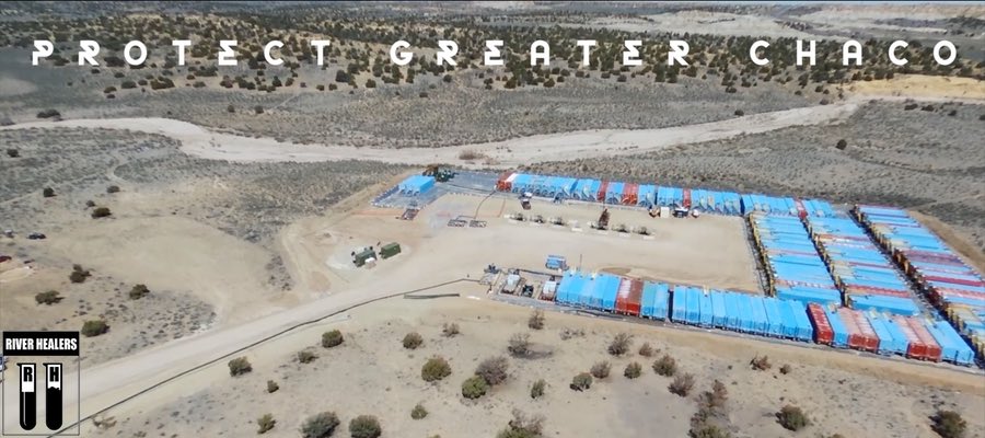
The River Healers have droned multiple fracking sites in the Greater Chaco Area (New Mexico) impacted by explosions, fires, spills, and methane. See what they are finding. Hear their story.
By Tom Burkett – River Healer Spokesperson, New Mexico Watchdog
The Greater Chaco region is known to the Diné (Navajo) as Dinétah, the land of their ancestors. It contains countless sacred sites that date to the Anasazi and is home of the Bisti Badlands and Chaco Culture National Historical Park, a World Heritage Site. Currently WPX Energy has rights to lease about 100,000 acres of federal, state, and Navajo allottee lands in the oil rich San Juan Basin, which includes Greater Chaco.1 WPX Energy along with other fracking companies plan to continue establishing crude oil fracking wells on these sacred lands, although the Greater Chaco community has spoken out against fracking and continue to call for more safety and oversight from New Mexico state regulatory bodies such as the EMNRD Oil Conservation Division.
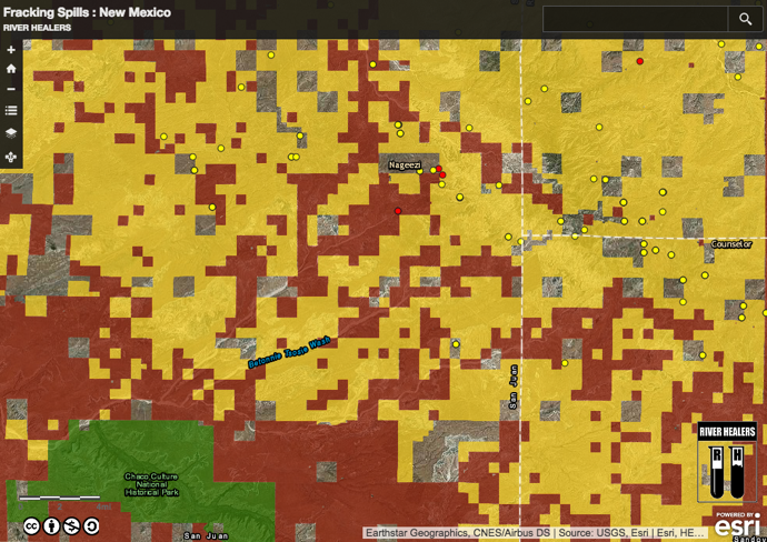
The River Healers pulled EMNRD records that show over 8,300 spills in New Mexico had been reported by the the fracking industry to EMNRD between 2011-2016 (map below). This is thousands more than reported by the Environmental Protection Agency. The records also showed how quickly reports of spills, fires, and explosions were processed by the EMNRD as ‘non-emergency’ and accepted industry reports that no groundwater had been contaminated.
Zoomed in view of the River Healers’ NM fracking spills map. Learn more
Daniel Tso, Member of the Navajo Nation and Elder of the Counselor Chapter, led us to fracking sites in Greater Chaco that had reported spills and fires. Daniel Tso is one of many Navajo Nation members working on the frontlines to protect Greater Chaco, their ancestral land, and their pastoral ways of life from the expanding fracking industry. Traveling in white trucks and cars we blended in with the oil and gas trucks that dot indigenous community roads and group around fracking pads on squares federally owned land. Years of watchdogging the fracking destruction on their sacred land was communicated through Tso’s eyes looking over the landscape for new fracking disruption and a calm voice,
… the hurt on the sacred landscapes; the beauty of the land is destroyed, this affects our people’s mental, spiritual, and emotional health.
At each site our eyes were scanning the fracking sites and terrain for drone flight patterns while the native elders were slowly scanning the ground for pottery shards and signs of their ancestors. Arroyos sweep around the fracking pads and display how quickly the area can flash flood from rain that gathers on the striated volcanic ash hills of the badlands.
Fracking Regulation in NM
The EMNRD Oil Conservation Division has only 12 inspectors that are in charge of overseeing over 50,000 wells scattered throughout New Mexico.2 Skepticism around EMNRD’s ability to regulate not only comes from a short staff being stretched across 121,598 square miles of New Mexico’s terrain, but thousands of active fracking sites continue to report spills, fires, and explosions every year.3 Even more problematic is that Ken McQueen, Cabinet Secretary of EMNRD formerly served as Vice President of WPX Energy.4 Ken McQueen managed WPX Energy’s assets in the Four Corners area of New Mexico, Colorado, and in addition, part of Wyoming. New Mexico Governor, Susana Martinez’s appointment of McQueen severely compromises the state’s ability to impartially oversee WPX Energy and regulate the fracking industry. Governor Martinez has been called to clean up the EMNRD, and rid the regulatory body of cabinet members more interested in protecting the assets of WPX than the health and rights of New Mexicans. Tso remarks,
The sacrifices of indigenous communities continue for a society that thinks gasoline comes from a gas station. That thinks oil is a commodity that is unending resource. This is unfortunate, and ultimately compromises our physical health. Yet this doesn’t matter to the industry. They want every last drop of crude oil even if it is cost prohibitive.
The River Healers maintain that Governor Martinez is complicit in the exploitation of human water rights as long as the EMNRD remains a compromised and unreliable regulatory body.
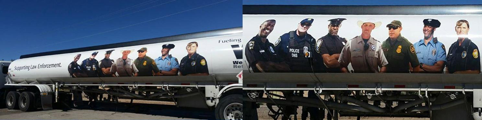
New Mexico governmental assimilation with the oil and gas industry is presented to the Greater Chaco indigenous communities in the form of 90,000-lb gross weight oilfield trucks. Western Refining started rolling out trucks with larger-than-life prints of state and county law enforcements officers and military personnel at the same time water protectors at Standing Rock were being arrested and assaulted by the Morton County Sheriff’s Department in North Dakota.5 The indigenous-led movement to stop the Dakota Access Pipeline from desecrating sacred land and threatening rights to clean water has drawn greater resistance to oil and gas projects around the country.
Indigenous solidarity is felt in Greater Chaco, but Western Refining’s blatant propaganda campaign demonstrates how oil and gas corporations continue to threaten and silence the communities they extract oil from by displaying the paid power of state and federal law enforcement. The River Healers view this as a direct form of intimidation that aims to further a corporate ideology and remind native communities of the violence they experienced at the hand of the United States Federal Government in the past. The Western Refining campaign is a direct form of corporate-sponsored terrorism and should be grounds to ban their ability to use images of law enforcement officers to further their interests. Furthermore, the state should discontinue paying for officers to patrol facking roads and pads and instead use state funds to make state regulatory bodies work for the communities most impacted by the oil and gas industries.
What we are finding
Drone surveillance of fracking sites in Greater Chaco show how quickly the fracking industry has exploited a state government tied to the interests of a booming and unchecked resource extraction industry. In Greater Chaco this element of time is more deeply understood through the lens of the indigenous community.
Ultimately, the health of the fauna and flora are devastated. The adaptation of the delicate ecosystem is forever destroyed. Their recovery and healing will take years and years.
The Anasazi Kivas in Chaco Canyon took over 300 years to construct, while drill rigs such as Cyclone 32 take less than 10 days to drill 6,500 ft wells in the canyon plateau. We hiked 12 miles of the sacred Chaco Wash, pulled water samples, and saw the red palm of the Supernova Petrograph clinging to the understory of the canyon wall, clearly taking notice of what is happening above.
We deeply thank members of the Navajo Nation for inviting us into their lives, and our hearts stand with them in solidarity. Protect Greater Chaco! Dooda Fracking!
River Healers Site Videos
Site 1
Nageezi, NM
County: San Juan
Kimbeto Wash/Chaco River
GPS: 36°14’22.38”, -107°43’51.38”
This particular site caught fire on June 11th, 2016 and was allowed to burn until July 14th. The fracking fire and contaminates spread to areas north and south of the fracking pad, burning Juniper trees within 200 feet of residential buildings. This fire is not the only documented case in the Greater Chaco Area where communities were disrupted and evacuated in the middle of the night. While community members remain concerned about their health, WPX reported that the incident was not an emergency and that no damage was caused to groundwater.
Site 2
Nageezi, NM
County: San Juan
Kimbeto Wash/Chaco River
GPS: 36°13’43.23″, -107°44’28.72″
Drone surveys of this particular site show Cyclone 32, a 1500 Horsepower 755 ton drill rig manufactured in Wyoming. The drill rig is transported through Greater Chaco communities on small dusty single lane dirt roads used by the community members and school buses. The drilling is heard and seen moving from pad to pad. The rig is establishing multiple drill heads on pockets of land tucked along the Kimbeto Wash, a tributary to the Chaco River and sacred source of water security for members of the Greater Chaco Area in Nageezi, New Mexico.
Site 3
Nageezi, NM
County: San Juan
Kimbeto Wash/Chaco River
GPS: 36°13’27.51″, -107°45’3.24″
No video available
Site 4
Counselor, NM
County: Rio Arriba
Canada Larga River
GPS: 36°13’18.19″, -107°28’56.24″
Drone surveys show Lybrook Elementary School only 1600ft from a WPX Energy fracking site. The crude oil tanks of the site can be seen from the classroom windows of the school. The elementary school was moved to this location in 2006 because it was right across the highway from a large and expanding natural gas plant and had to relocate elementary students to a safe location.
Although the WPX Energy site is established on federal land, this area of Counselor, New Mexico is referred to as ‘The Checkerboard’ because of the quadrants of federal land that break up tribal land. The 5 well heads are highlighted to show that these pockets of federal land are being fracked with a high concentration of fracking wells. By drilling multiple wells in one pad location fracking companies are able to quickly drain the plays of crude oil under the the Greater Chaco Area and avoid signing contracts with the native property owners that live and attend school in the area they are fracking.
Drone surveys show crude oil being fracked within 840 ft of an indigenous community in Sandoval County, NM (Greater Chaco). The fracking site is located in the path of the community water supply, which had to be routed around the wellhead and crude tanks. The underground water line remains only 110 ft from active fracking activity.
Particular communities in Greater Chaco are dependent upon pastoral industry and the health of their livestock. Horses owned by the indigenous community are seen grazing on open and unprotected fracking pads. Many of these fracking pads have recorded spills of either fracking fluid, wastewater, or crude oil and pose health risks to the livestock grazing on potentially contaminated grasses and wastewater.
A Western Refining (WPX) crude truck can be seen driving down the community road. These dirt roads were designed to support local community traffic and school buses but are now heavily used by the fracking industry. 90,000-lb gross weight oilfield trucks haul the volatile crude oil through pastoral lands, endangering livestock and community members. Fracking companies continue to level dirt roads to accommodate the weight of their crude trucks. The practice cuts roads deep into the landscape. Roads in Greater Chaco now resemble trenches and make travel dangerous, block scenic views of ancestral land, and hinder the ability to monitor livestock and fracking development.
Site 6
Nageezi, NM
County: San Juan
Kimbeto Wash/Chaco River
GPS: 36°15’20.46”, -107°41’43.14”
Drone surveys show 3 well heads, crude tanks, and compressors north of Hwy 550 in Nageezi, NM. The location is of importance because it shows how flaring is used to burn off methane caused by fracking and the transportation processes of crude oil. The River Healers droned this site when workers were not present and the flare tower was turned off for safety concerns, but the flame can usually be seen all the way from Hwy 550 tucked into the distinct hills of the Bisti Badlands. Such methane hotspots are of concern because methane causes severe health risks for individuals living near crude oil facilities. NASA has identified two large methane gas clouds in new Mexico. The methane gas is concentrated above fracking occurring in the San Juan Basin and Permian Basin and disproportionately affects the air quality of Greater Chaco, Four Corners Region, Farmington, and South East region of New Mexico.
Two unlined wastewater pits can be seen on the edge of the fracking pad near the well heads and compressors. Erosion caused by water drainage can be seen leading from the well heads and compressor areas directly to the wastewater pits. Drainages can also be seen coming directly out of the waste water pits and going into the Upper Kimbeto Wash, a tributary of the Chaco River. It is illegal for fracking companies to keep fracking wastewater in unlined pits in the state of New Mexico. The River Healers reported this possible water violation to the EMNRD Oil Conservation Division (a state regulatory body for the fracking industry). EMNRD replied that WPX Energy maintains that the wastewater is caused by stormwater runoff and contains no fracking contaminates. This is the first time we have heard of the fracking industry creating stormwater runoff pits and find the practice to be unusual. Further skepticism that these runoff pits are not contaminated comes from research about the site. In June of 2016, WPX Energy reported a spill of 600 gallons of crude oil at this site because of a fire. WPX maintains that no groundwater was impacted and marked the incident as not an emergency.
The River Healers organize anonymous watchdog operations and tactical campaigns to protect water. The artist collective is engaged in direct action through analyzing, exposing, and bringing down systematic abuses of water rights. The River Healers work to accelerate theories of water democracy, decentralize aesthetics of environmentalism, and expose corporate sponsored water terrorism. ‘Water is a commons – No one has the right to destroy’
https://www.fractracker.org/a5ej20sjfwe/wp-content/uploads/2017/09/River-healers-video-feature.jpg400900Guest Authorhttps://www.fractracker.org/a5ej20sjfwe/wp-content/uploads/2025/09/2025-Wordmark-Logo.pngGuest Author2017-09-21 09:30:482021-04-15 15:02:33Protect Greater Chaco: Drone surveillance of regional fracking sites in NM
Increasingly, the FracTracker Alliance is asked about oil and gas extraction on a national scale. To that end, we are in the process of developing a national dataset of oil and gas wells. Since the data is curated at the state level, it is a challenge to get consistent data formatting from state to state. However, most states at least have the decency to release their location data in decimal degree (DD), that familiar format of latitude and longitude values where users of the data don’t need to calculate the location using three different columns of degrees, minutes, and seconds (DMS).
For example, a DMS point of 45°12’16.4″N, 95°55’12.5″W could be written more tidily in DD as 45.204556, -96.920139. Two numbers, one discrete place on the globe (a random point in rural South Dakota, as it turns out).
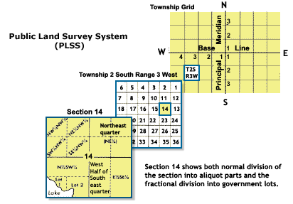
Here is how that same location is properly designated using the Public Land Survey System: “NW 14 T120N R51W Fifth Principal”
Fig. 1 Public Land Survey System. Source: National Atlas
In English, that is the northwest quarter of Section 14, Township 120 North, Range 51 West Fifth Principal. If we wanted to, the quarter section could itself be split into four quarters, and each of those units could be split again, resulting in, for example the SE quarter of the NE quarter of the NW quarter of section 14, Township 120 North, Range 51 West Fifth Principal (See Fig. 1).
To the uninitiated, the PLSS is a needlessly complex system of describing locations in the American West that was devised by Thomas Jefferson to grid out the wild American frontier. As such, it is not altogether surprising that it became the legal definition of place in many western states.
What is surprising is that the system is still in use, at least to the exclusion of other systems. Many states release oil and gas data with multiple geographic systems, including the PLSS, State Plane, UTM, and decimal degrees. This is an acceptable approach, as it caters to cartographers using technology ranging from the eighteenth through twenty-first centuries.
Accuracy Issues
My issue with the PLSS isn’t just that it is annoying. PLSS data are readily available, after all. Differing formats of the various data attributes can be worked out. However, there is inherently an accuracy issue with a system that uses a predefined area to define a point location. If you wanted to use it to describe an area such as a well pad, it is entirely possible that a typical drilling site might straddle four different sections, let alone quarter-quarter-quarter (QQQ) sections. For that matter, well pads could easily span multiple township and range designations, as well.
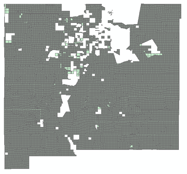
Fig. 2 PLSS sections in New Mexico
Statewide shapefiles that are as detailed as sections are quite large, and are the most detailed data that most data sources offer. This means that the best we can usually do with well data published in PLSS is draw the well at the centroid, or geographical center-point of the section, which in theory is one square mile. Given that the hypotenuse of a square mile block is 1.44 miles, the distance from the centroid to any of the corners is 0.72 miles, or about 3,800 feet, which is the potential error for mapping using PLSS section centroids. While that lack of accuracy is unsatisfying for the FracTracker Alliance, the whole system is a potential nightmare for first responders, in an industry where serious things can go wrong.
In some states, the entire land areas were never even gridded out. New Mexico, for example, has Native American reservations and extensive lands grants that were issued when the region was under Spanish and Mexican control (Fig. 2).
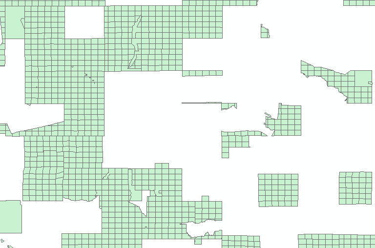
On top of all of that, those square mile sections are not always square. These sections are based on field surveys that were mostly conducted in the 19th century. Walking straight lines in rough terrain isn’t actually all that easy, and in many cases, areas with ferrous deposits in the soil can interfere with the functionality of a magnetic compass. If we take a closer look at the New Mexico sections map (Fig. 3 below), we can see that error is significant.
Moving Forward
Fig. 3 Areas in green show PLSS Sections in North-Central New Mexico. Areas in white were not gridded out as a part of the survey.
Luckily, we live in an age where technology makes Thomas Jefferson’s valiant attempt at a coordinate system obsolete. Decimal degree is a format that is well understood by GPS devices, Google Maps, sophisticated GIS software, and for the most part, the general public. For mapping purposes, decimal degree is so easy to use and so widely established that other systems, especially the PLSS, come across as needlessly opaque.
This situation is not even analogous with the United States’ famous reluctance to embrace the metric system. It takes some adjustment for people to start thinking in terms of kilograms and meters instead of pounds and feet. PLSS isn’t remotely intuitive as a coordinate system, even among those who use it all the time. It’s time to abandon this as a way of conveying location. I’d like to think that Thomas Jefferson, as a forward-thinking individual, would agree.
Recently, the FracTracker Alliance has gotten several requests from residents of New Mexico for maps showing the large scale drilling operations in that state. As we began to look around for data sources, we encountered an interesting document from 2008:
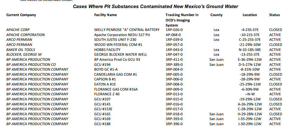
This 2008 document from the New Mexico Oil Conservation Division shows instances of ground water contamination by oil and gas pits in the state.
There isn’t much description on the document or the New Mexcio Oil Conservation Division (NMOCD) page that links to it, however, the subject matter is straightforward enough. Altogether, there are 369 instances of ground water contamination documented by a New Mexico governmental agency from dozens of drilling operators throughout the Land of Enchantment.
Ground Water Contamination Controversy
Since the title of document indicates that the agents causing contamination are “pit substances”, this does not technically indicate that hydraulic fracturing is to blame. This is largely a matter of definition, but it is an important one to understand, because the word “fracking” means something different to industry insiders than it does to the general public, and the issue of ground water contamination is a point of considerable debate.
Technically speaking, hydraulic fracturing only refers to one stage of the well completion process, in which water, sand, and chemicals are injected into the oil or gas well, and pressurized to break up the carbon-rich rock formation to allow the desired product to flow better.Most people (and many media outlets) consider “fracking” to be the entire production process for wells that require such treatment, from the development of the several acre well pad, through the drilling, the completion, flaring, waste disposal, and integration of the product to pipelines. (It is due to these competing definitions that the FracTracker Alliance goes out of our way to avoid the term “fracking”.)
All of this has lead to some carefully worded statements that seem to exhonerate hydraulic fracturing, despite suspected contamination events reported in Pennsylvania, Wyoming, and elsewhere. Of course, from the perspective of residents relying on a contaminated aquifer, it hardly matters whether the water was contaminated by hydraulic fracturing, leeching from the associated pits, problems with well casing or cement, or re-pressurized abandoned wells. A fouled aquifer is a fouled aquifer.
This document does not specify what was contained in the pits, only that they are contamination events. Therefore, we do not know what stage of the process the contaminant came from, only that it was believed by the state of New Mexico to have originated from a pit, and not the well bore itself.
Notes About Location Information
It is important to note that the location information is not exact, but are generally within 0.72 miles of the specified location. The reason for this is that the location information was provided using the Public Land Survey System (PLSS). The brainchild of Thomas Jefferson, the PLSS was the method used to grid out the western frontier, and it is still used as a legal land description in many western states. Essentially, the land was divided into townships that were six miles by six miles, which was then broken into 36 sections, each of which is one square mile. FracTracker has calculated the centroid of each section, which could be up to 0.71 miles from the corner of the same section if the shape is perfectly square.
The PLSS system was used to grid out most of New Mexico, but some portions of the state had already been well defined by Spanish and Mexcian land grants. Aside from being a fascinating historical anecdote, it does have an effect on the mapping of these pits. In the image of the table above, note that the “Florance Z 40” well does not have any values in the location column. As a result, we were not able to map this pit. Altogether, 11 of the 369 pits identified as causing groundwater contamination could not be mapped.
New Mexico Shale Viewer. You can zoom and click on map icons in this window for more information. For full access to map controls, including layer descriptions, please click the expanding arrows icon in the top right portion of the map.
 Sarah Carballo, FracTracker Alliance, 2022