Controversy in the Loyalsock
By Mark Szybist, Staff Attorney, PennFuture
What are the Clarence Moore Lands?
The Clarence Moore lands are 25,621 acres of “split estate” lands in the Loyalsock State Forest where the surface rights are owned by the Commonwealth of Pennsylvania and the oil and gas rights are owned by two private parties – an affiliate of Anadarko Petroleum Corporation (Anadarko) and a private company called International Development Corporation (IDC). The Pennsylvania Department of Conservation and Natural Resources (DCNR) calls this acreage the “Clarence Moore lands,” after an individual who once owned the area’s oil and gas interests.
What is the controversy over the Clarence Moore lands?
The Clarence Moore lands have become controversial because Anadarko wants to drill gas wells on them (and build compressor stations, water impoundments, pipelines, and new roads). Because of the ecological and recreational sensitivity of the Clarence Moore lands, PA’s conservation community (and much of the general public) wants the DCNR to use its substantial powers to minimize surface activities, if not prevent them altogether.
In general, when a “split estate” exists in PA, the party that owns or controls the oil and gas estate has an implied right to use the surface that it does not own in order to extract oil and gas. The Clarence Moore lands present an exception to this rule. Due to a provision in the Commonwealth’s deed, the DCNR has the power to deny Anadarko access to 18,870 acres of the Clarence Moore lands – almost 75%. To obtain access, Anadarko needs a right-of-way from the DCNR. Conservationists are arguing that given this power, the DCNR has leverage to protect all of the Clarence Moore lands – including the 6,841 acres where Anadarko appears to have traditional “split estate” surface rights.
In March 2012 Anadarko submitted to the DCNR a development plan for the Clarence Moore lands. For almost a year, a coalition of conservation, recreation, fishing and hunting organizations (and thousands of private citizens) have been pressing the DCNR to conduct a public input process on the Clarence Moore lands before making any agreement with Anadarko. The coalition wants the DCNR to make public its environmental impact analyses, allow public comment on all development and non-development alternatives, and protect the Clarence Moore lands for future generations of Pennsylvania citizens. In April 2013 the DCNR conducted an invitation-only meeting about the Clarence Moore lands for “local stakeholders,” followed by a webinar in collaboration with the Penn State Extension of the Penn State College of Agricultural Sciences. The DCNR announced on May 22, 2013 that it would hold a public meeting in Williamsport on June 3rd.
Why are the Clarence Moore lands so important?
The Clarence Moore lands are a wealth of ecological and recreational resources. They include the Old Loggers Path (OLP), an acclaimed 27-mile hiking trail that follows former logging trails and opens onto stunning vistas. According to DCNR documents, the OLP “will be taking the brunt of development [from Anadarko’s activities].”
The Clarence Moore lands include most of the watershed of Rock Run, an Exceptional Value (EV) stream widely hailed as the most beautiful stream in Pennsylvania. The headwaters of Rock Run and Pleasant Stream, another EV stream, emerge from ridge-top wetlands that provide habitat for several threatened or endangered plant and animal species.
The Clarence Moore lands provide habitat for numerous plant and animal species that Pennsylvania has classified as threatened, rare, or at risk (or determined to be candidates for these classifications). Among these species (to name just a few): the timber rattlesnake, northern water shrew, creeping snowberry, northern bulrush, northern goshawk, and yellow-bellied flycatcher. The Clarence Moore lands have been designated an Important Bird Area by the Audubon Society. (See p. 82 of this PDF).
Finally, the Clarence Moore lands are one of only a few large public land areas in north-central PA that have not been opened to gas development, and still contain relatively unfragmented forests. The DCNR has already leased almost 21,000 other acres of Loyalsock (the forest is around 114,000 acres in all), and has also leased much of the Tiadaghton State Forest to the west and the Tioga State Forest to the north.
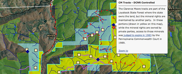
FracTracker map of Clarence Moore Lands and Activity
The map above shows the Clarence Moore lands as yellow and blue areas within the Loyalsock State Forest. In the yellow areas, the DCNR has exclusive control of the surface. In the blue areas, Anadarko has the right to use the surface to extract oil and gas. The locations of the yellow and blue Clarence Moore areas are based on documents obtained by PennFuture through the Pennsylvania Right to Know Law (RTKL) and on maps that the DCNR presented at the April 2013 webinar noted above.
The map also shows the oil and gas wells, pipelines, roads, compressor stations, and impoundments that conservationists believe Anadarko has proposed to build in the Clarence Moore lands. The locations of this infrastructure are based on the RTKL documents and on hikers’ observations of survey flags within the Loyalsock State Forest.
Questions and comments about this issue or the June 3rd public meeting can be directed to Mark Szybist: Szybist@pennfuture.org.
What is the exact language in the deed that was described above as “a provision in the Commonwealth’s deed?” I would assume the language affords the State discretion over how or if the surface can be utilized. Is this a unique situation or have other landowners had similar verbage in their deeds? Have there been similar situations where the same language exists and either the landowners controlled the development or the corporations fought the provision and won in court?
Fred,
The relevant language from the deed — which, yes, gives the Commonwealth exclusive surface control over 18,870 acres of the Clarence Moore lands — is what lawyers call a “reservation clause.” The Central Pennsylvania Lumber Company used the provision to reserve (i.e., keep) to itself the oil and gas under the 18,870 acres when it sold the surface to the Commonwealth. (The deed did not reserve the oil and gas under the remainder of the Clarence Moore acreage because that oil and gas had already been sold). The provision reads as follows:
“Also excepting and reserving unto the Grantor, its successors and assigns, all the oil, coal and gas now owned by it, the said Central Pennsylvania Lumber Company, in, under and upon the aforementioned and described four parcels of ground, with the rights of ingress, egress and regress upon and over said tracts of land for and during the term of fifty (50) years from the date of conveyance, together with the use of any part of the surface in the operation, development, protection and transportation of any oil, coal and gas according to such rules and regulations as may be from time to time adopted by the Secretary of the Department of Forests and Waters, but such rules shall at all times be reasonable and in harmony with the usual methods of operating and producing oil, coal and gas.”
For a long time, both the Commonwealth and CPLC (and then Clarence Moore, who eventually acquired the oil and gas interests) assumed that when the 50-year period ended in 1983, the Commonwealth would acquire ownership of the oil and gas. After all, that seems to be what the provision dictates. But after protracted litigation, the Commonwealth Court ruled that what the Commonwealth got in 1983 was not ownership of the oil and gas, but the surface rights that normally accompany ownership. Hence the situation today. The citation for the decision is Clarence Moore v. DER, 129 Pa. Commw. 628, 566 A.2d 905 (Pa. Commw. 1989).
I wouldn’t be surprised if other deeds of the period contained similar language. I would be very surprised if litigation over any of those deeds led to a result as peculiar as the one affecting the Clarence Moore lands.
I am a lifelong outdoor enthusiast, I enjoy outdoor sports that range from hunting and fishing to hiking and spelunking. I have insight on the subject of gas well drilling due to having worked on a drilling rig for eight months in 2011. While I agree with the premise of energy independence, I have personally witnessed the effects of gas well drilling on pristine wilderness locations, and I have experience with the mindset of the people who do that work. Energy independence is not worth the cost of destroying the natural beauty of all of our forests and mountains. The people in charge of these drilling rigs, well pads, and pipelines care naught about permanent damages they create and the poisonous substances they leak, spill, and pump into the ground all in the name of making money. Please, for God;s sake, for Mother Nature’s sake, for the sake of our children’s right to experience our wealth of natural beauty, Please don’t let the energy companies destroy everything…they have enough other areas that they can drill their wells, run their pipelines, and spill their poisons on….
Ban fracking now. We need the forests as our watersheds and as users of carbon dioxide. We all need clean air and clean water. When the Fossil Fuel Empire can PROVE that it does not harm Mother Earth, they may continue. […]
It is likely that there are additional features related to gas extraction in the Clarence Moore tracts.
This map is one of several documents that were provided on which the FracMapper map was built. It was provided to Penn Future by DCNR as a part of a Right-to-know law request. Note the low resolution and illegible legend. This is one of the source documents that was used to build the FracMapper map that is embedded above. It is notable for containing features that other source documents of the same area do not include–additional pipelines and compressors, for example.
In addition, there are likely more features that are still not included on even this map. Each of the well pads are likely to connected by gathering pipelines, for example.
Please note that some of the pipelines are co-located with local roads. That layer is turned off by default, but can be added in the “Layers” section by clicking the check box next to the item.