Oil and Gas Flood Contamination Risk Incalculable on CO Front Range
By Sierra Shamer, Visiting Scholar, FracTracker Alliance
Historic 2013 flooding in the Colorado Front Range damaged homes, bridges, roads, and other infrastructure — including hundreds of oil and gas facilities. Companies shut down wells and scrambled to contain spills in their attempts to prevent extensive water contamination. Colorado has since adopted new regulations that require oil and gas companies to identify and secure all infrastructures located within floodplains. However, FEMA’s Flood Hazard maps, which the state uses to calculate flood risk, are largely incomplete, leaving only the industry accountable for reporting facilities that may be at risk in future flooding events. This article highlights the unknown flood contamination risk threatening the Front Range by oil and gas, and the featured map identifies known floodplain infrastructure.
Front Range Realities

Counties of the Colorado Front Range
The Colorado Front Range is the most populated region of the state, covering 17 counties and 7 cities including Boulder, Denver, and Colorado Springs. This region has experienced devastating flash flooding events throughout history, most notably the Big Thompson flood of 1976, which dumped 12-14 inches of rain along the Front Range in only 4-6 hours. The 2013 Colorado Front Range Flood brought almost 15 inches to the region, 9 of which falling within a period of 24 hours. A state of emergency was declared in the region and recovery projects continue to this day.
The Front Range region is not only one of the most populated in Colorado, it is also home to 40% of Colorado’s oil and gas wells. Oil and gas development occurs so rapidly that data reports on pending permits, active permits, and well locations are updated daily by the Colorado Oil and Gas Conservation Commission (COGCC). The damage to oil and gas facilities due to the 2013 floods prompted the COGCC to adopt Rule 603.h, requiring companies to identify proposed and current infrastructure within the floodplain and to create flood mitigation and response plans. On April 1st of this year, all companies with existing infrastructure must comply with Rule 603.h. With over 109,000 wells in the state, an incomplete FEMA database, and only 22 field inspectors, the COGCC has limited capacity to ensure these reports identify all infrastructure within the floodplain.
FEMA Floodplain Gaps
The Federal Emergency Management Agency (FEMA) maintains a national map of the 100-year floodplain for insurance determinations that are in the process of being digitized. These maps show the extent of flooding expected from rain events with a 1% chance of occurring in any given year. They are determined by a combination of topography, satellite imagery, and maps from local jurisdictions. However, in many portions of the western US, these mapped areas are incomplete, including large regions of Colorado. FEMA maps are also the primary floodplain data source used by industry and the by the COGCC. The map below shows the oil and gas infrastructure that is located within the known digital 100-year floodplain as of early February 2016. This map underrepresents the actual number of facilities within the floodplains due to incomplete FEMA data, but provides a clear visual of a widespread problem.
Known Floodplain Infrastructure Map
View full screen map | How to work with our maps | Download map data
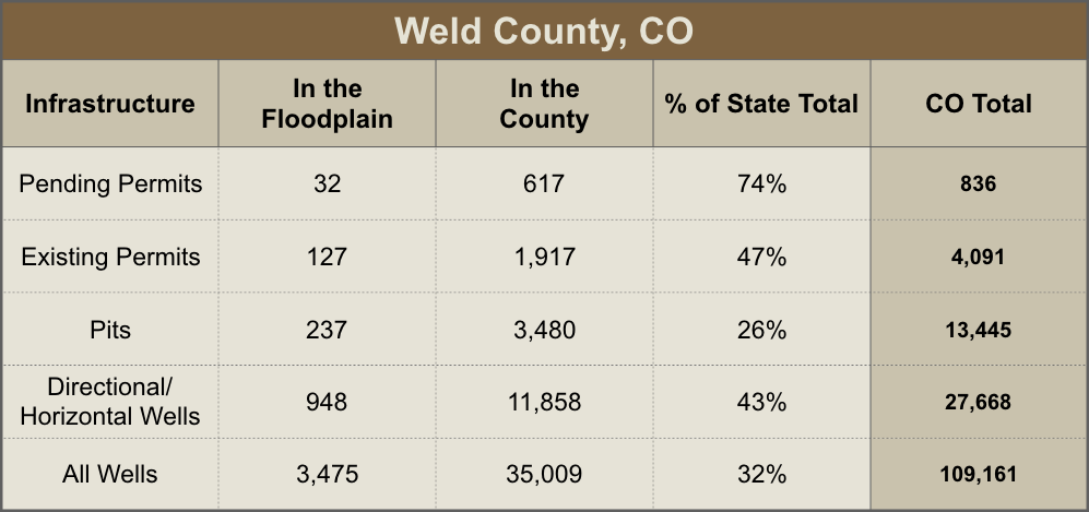
Although FEMA is routinely working to update their dataset, large regions with widespread extraction remain digitally unmapped. While there is accessible floodplain info for the companies to use to determine their status and for the COGCC to verify what the industry reports, the incomplete digitized FEMA data means there is no accessible or efficient way for the COGCC to know if there is infrastructure within a floodplain that hasn’t been reported. This means that more is at risk here than we can calculate. Weld County, a Front Range county and recipient of severe flooding in 2013, starkly exemplifies this reality. In the aftermath of the 2013 flood, Weld County became a disaster zone when 1,900 oil and gas wells were shut down, submerged completely by the rushing water, as thousands of gallons of oil drained out. Until January 2016, Weld County lacked digitally mapped floodplains, and currently only 16% of the river and stream network is available.
The table below lists the percentages of oil and gas infrastructure that exist in Weld County alone that can be calculated using this limited dataset. As of February of this year, 3,475 wells of 35,009 are within the known floodplain in Weld County. Of greater concern, 74% of pending permits statewide are in Weld County – 5% of those in the known floodplain – indicating either an underestimation of flood risk, a blatant disregard of it, or both.
Flooding in the Future
According to the CO Climate Change Vulnerability Study, the state expects a 2.5–5 degree Fahrenheit annual temperature increase by 2050. While this increase is likely to cause earlier spring runoff, more rain at lower elevations, and higher evaporation rates, it is unclear if annual precipitation will increase or decrease with rising temperatures. This uncertainty makes it difficult to know if increased flood risk is in the future. Current flood risk, however, is a known threat. The CO Department of Public Safety’s Flood Hazard Mitigation Plan calculates, based on historical events, that Colorado experiences a flood disaster once every five years. This means that each year, there is a 20% chance a major flood will occur. With incomplete data, limited oversight, and uncertain future trends, oil and gas flood contamination risk is incalculable – and on the Front Range, the majority of Colorado’s population, extractive industry, and environment are in danger. The unknown risks of climate change and known risks of historical flood trends emphasize that identifying oil and gas infrastructure in floodplains must be a high priority for the COGCC. These realities also put into question whether or not future infrastructures should be permitted within floodplains at all. In April, floodplain infrastructure will be identified by the industry and when these data are made available, a more accurate analysis of risk will me made.
Dealing with the Unknown
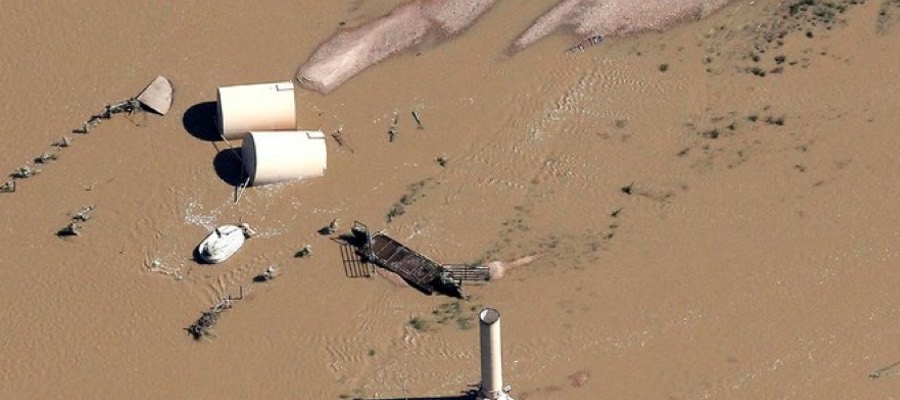
Feature photo shows a flooded well and toppled oil storage tanks in Weld County, Colorado 2013 – by Rick Wilking/Reuters.
Exceptional work. Thank you from your planet.