Mariner East 2 and Watershed Risks
Mariner East 2 (ME 2) is a $2.5 billion, 350 mile-long pipeline that, if built, would be one of the largest pipeline construction projects in Pennsylvania’s history—carving a fifty-foot wide path through 17 counties. A project of Sunoco Logistics, ME 2 would have the capacity to transport 275,000 barrels a day of propane, ethane, butane, and other hydrocarbons from the shale fields of Western Pennsylvania and neighboring states to an international export terminal in Marcus Hook, located on the Delaware River.
ME 2 has sparked a range of responses from residents in Pennsylvania, however, including concerns about recent pipeline accidents, the ethics of taking land by eminent domain, and the unknown risks to sensitive ecosystems. Below we explore the watersheds that could be impacted by this proposed pipeline.
Watershed Impacts
While some components of Sunoco’s ME 2 proposal are approved, the project requires more permits from the Pennsylvania Department of Environmental Protection (DEP) before construction can begin. Among those are permits to build through and under stream and wetlands. Many of the waters threatened by ME 2 are designated by the Commonwealth as “exceptional value” (EV) or “high quality” (HQ) and are supposed to be given greater protections from harm. Water Obstruction and Encroachment Permits, also known as “Chapter 105” permits, are required for any building activities that would disrupt any body of water, including wetlands and streams. Sunoco applied for these so-called “Chapter 105” permits in the summer of 2015, but its applications were rejected as incomplete several times.
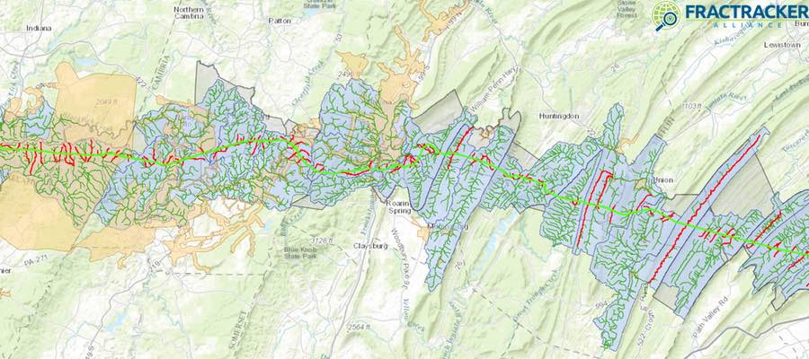
The below map shows the ME 2 route as of May 2016 relative to the watersheds and streams it will cross. Zoom into the map to see additional layers. Note that this is the most accurate representations of ME 2’s route we have seen to date. MWA provided the shapefiles for ME 2’s route to FracTracker Alliance and continues its investigations into potential watershed impacts.
Proposed ME 2 Route
View map full screen | How FracTracker maps work
In total, ME 2’s path will include 1,227 stream crossings, 570 wetland crossings, and 11 pond crossings. Of the 1,227 stream crossings, 19 are EV and 318 are HQ, meaning that 337 crossings will disturb what DEP refers to as “special protection” waters. In addition, there are 129 exceptional value wetlands being crossed. These numbers were compiled by Mountain Watershed Association (MWA) from Sunoco’s permitting applications. MWA also identified 2 HQ streams in Washington County, and 3 HQ streams in Blair County, that are proposed to be crossed that are not acknowledged as being HQ in Sunoco’s permits.
Public Comment Period Open
People living along the proposed route are sometimes in the best position to see what the route looks like from the ground, where wetlands and streams are, and what kinds of wetlands and streams they are. The DEP is accepting public comments on Sunoco’s ME 2 Ch. 105 permit application through Wednesday, August 24. Each DEP regional office receives separate Ch. 105 applications depending on where the pipeline routes through different counties. Those wishing to comment on the project can do so through the DEP regional office websites: DEP Southwest Region, DEP South-central Region, DEP Southeast Region. For guidance on how to write comments on permits, see MWA’s Pipeline Project Information & Talking Points.
We wish to thank Mountain Watershed Association and the Clean Air Council for helping us compile data and analysis for this article.
Written by Kirk Jalbert, PhD, MFA – Manager of Community-Based Research & Engagement, FracTracker Alliance
Thank you for your hard work and this great resource.