Waiting on Answers Weeks after a Well Explosion in Belmont County Ohio
Mar 7 Update: The well has finally been capped.
On February 15, 2018, officials evacuated residents after XTO Energy’s Schnegg gas well near Captina Creek exploded in the Powhatan Point area of Belmont County, Ohio. More than two weeks later, the well’s subsequent blowout has yet to be capped, and people want to know why. Here is what we know based on various reports, our Ohio oil and gas map, and our own fly-by on March 5th.
March 19th Update: This is footage of the Powhatan Point XTO Well Pad Explosion Footage from Ohio State Highway Patrol’s helicopter camera the day after the incident:
Powhatan Point XTO well pad explosion footage from Ohio State Highway Patrol
Cause of the Explosion
The well pad hosts three wells, one large Utica formation well, and two smaller ones. XTO’s representative stated that the large Utica well was being brought into production when the explosion occurred. The shut-off valves for the other two wells were immediately triggered, but the explosion caused a crane to fall on one of those wells. The representative claims that no gas escaped that well or the unaffected well.
Observers reported hearing a natural gas hiss and rumbling, as well as seeing smoke. The Powhatan Point Fire Chief reported that originally there was no fire, but that one later developed on the well pad. To make matters worse, reports later indicated that responders are/were dealing with emergency flooding on site, as well.
As of today, the Utica well that initially exploded is still releasing raw gas.
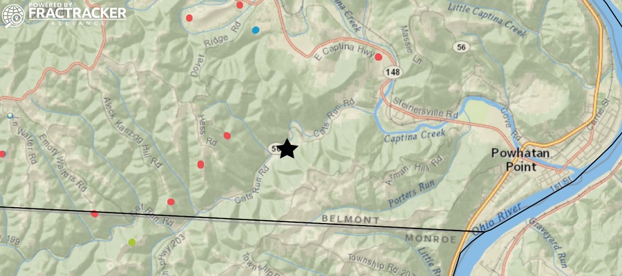
Map of drilling operations in southeast Ohio, with the Feb 15, 2018 explosion on XTO Energy’s Schnegg gas well pad marked with a star. View dynamic map
Public Health and Safety
No injuries were reported after the incident. First responders from all over the country are said to have been called in, though the mitigation team is not allowed to work at night for safety reasons.
The evacuation zone is for any non-responders within a 1-mile radius of the site, which is located on Cat’s Run Road near State Route 148. Thirty (30) homes were originally evacuated within the 1-mile zone according to news reports, but recently residents within the outer half-mile of the zone were cleared to return – though some have elected to stay away until the issue is resolved completely. As of March 1, four homes within ½ mile of the well pad remain off limits.
The EPA conducted a number of site assessments right after the incident, including air and water monitoring. See here and here for their initial reports from February 17th and 20th, respectively. (Many thanks to the Ohio Environmental Council for sharing those documents.)
Much of the site’s damaged equipment has been removed. Access roads to the pad have been reinforced. A bridge was recently delivered to be installed over Cats Run Creek, so as to create an additional entrance and exit from the site, speaking to the challenges faced in drilling in rural areas. A portion of the crane that fell on the adjacent wellhead has been removed, and workers are continuing their efforts in removing the rest of the crane.
The above video by Earthworks is optical gas imaging that makes visible what is normally invisible pollution from XTO’s Powhatan Point well disaster. The video was taken on March 3, 2018, almost 3 weeks after the accident that started the uncontrolled release. Learn more about Earthworks’ video and what FLIR videos show.
An early estimate for the rate of raw gas being released from this well is 100 million cubic feet/day – more than the daily rate of the infamous Aliso Canyon natural gas leak in 2015/16. Unfortunately, little public information has been provided about why the well has yet to be capped or how much gas has been released to date.
Bird’s Eye View
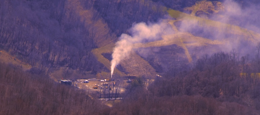
On February 26, a two-mile Temporary Flight Restriction (TFR) was enacted around the incident’s location. The TFR was supposed to lapse during the afternoon of March 5, however, due to complications at the site the TFR was extended to the evening of March 8. On March 5, we did a flyover outside of the temporary flight restriction zone, where we managed to capture a photo of the ongoing release through a valley cut. Many thanks to LightHawk and pilot Dave Warner for the lift.

XTO Energy well site and ongoing emissions after the explosion over two weeks ago. Many are still waiting on answers as to why the well has yet to be capped. Photo by Ted Auch, FracTracker Alliance, March 5, 2018. Aerial support provided by LightHawk
Additional resources
Per the Wheeling Intelligencer – Any local residents who may have been impacted by this incident are encouraged to call XTO’s claims phone number at 855-351-6573 or visit XTO’s community response command center at the Powhatan Point Volunteer Fire Department, located at 104 Mellott St. or call the fire department at 740-312-5058.
Sources:
- February 15, 2018 – WTOV9 – Well pad explosion, fire forces evacuations in Powhatan Point area
- February 15, 2018 – WTOV9 – Officials evaluating options for containment after explosion, fire on well pad
- February 17, 2018 – US EPA – Pollution Situation Report 1
- February 20, 2018 – US EPA – Pollution Situation Report 2
- March 1, 2018 – Wheeling Intelligencer – XTO Well Pad Still Leaking in Powhatan Point, Two Weeks Later
Thanks for your support, Peter.