Infrastructure
Learn about infrastructure related to the oil and gas industry through FracTracker articles, maps, and imagery.
Learn about infrastructure related to the oil and gas industry through FracTracker articles, maps, and imagery.
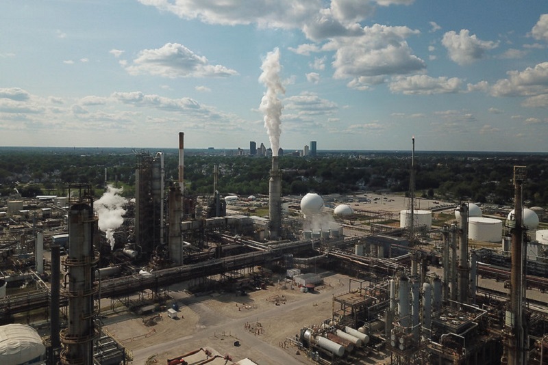
Infrastructure to support unconventional oil and gas development has increased substantially in the past decade. Major fracking infrastructure includes:
Machine that raises the pressure of gas by drawing in low pressure gas and discharging it at significantly higher pressures. These facilities enable natural gas to flow through pipelines.
In the United States, there’s an estimated 3 million miles of pipelines transporting crude oil, refined petroleum products, natural gas liquids, and gas from fracking wells and cryogenic facilities to processors & then eventually to consumers. Pipelines include distribution lines that take gas to residents and other consumers, as well as transmission and gathering lines which bring fossil fuels from well sites to processing facilities and distant markets.
“Fracking” wells are drilled thousands of feet into the ground to reach a target oil or gas reservoir. The well then turns horizontally to intersect and remain within the reservoir (e.g. shale layer) for distances that can reach over three miles in length. A mixture of water, sand and chemicals are injected into the well at extremely high pressures, and explode out of the well bore to crack open the shale rock, releasing oil and gas.
Other infrastructure includes Class II wells (which include wastewater disposal wells, enhanced oil recovery wells, and hydrocarbon storage wells), cryogenic facilities, frac sand mines, fractionation facilities, petrochemical facilities, power plants and stations, processing plants, pumping stations, and storage facilities. For more information on the function of these infrastructure, see FracTracker’s Oil & Gas 101 guides: https://www.fractracker.org/resources/oil-and-gas-101/
 https://www.fractracker.org/a5ej20sjfwe/wp-content/uploads/2020/09/Methane_Air_WaterQualityConcerns-1.jpg
534
800
FracTracker Alliance
https://www.fractracker.org/a5ej20sjfwe/wp-content/uploads/2025/09/2025-Wordmark-Logo.png
FracTracker Alliance2023-01-31 15:01:342023-02-27 16:43:15Testimony On EPA’s Proposed Methane Pollution Standards for the Oil and Gas Industry
https://www.fractracker.org/a5ej20sjfwe/wp-content/uploads/2020/09/Methane_Air_WaterQualityConcerns-1.jpg
534
800
FracTracker Alliance
https://www.fractracker.org/a5ej20sjfwe/wp-content/uploads/2025/09/2025-Wordmark-Logo.png
FracTracker Alliance2023-01-31 15:01:342023-02-27 16:43:15Testimony On EPA’s Proposed Methane Pollution Standards for the Oil and Gas Industry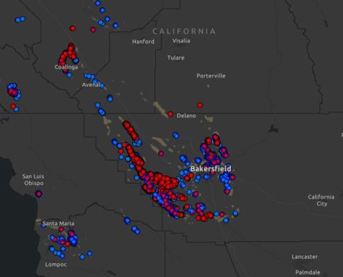 https://www.fractracker.org/a5ej20sjfwe/wp-content/uploads/2023/01/California-Rework-Permits-2023.jpg
541
1500
Kyle Ferrar, MPH
https://www.fractracker.org/a5ej20sjfwe/wp-content/uploads/2025/09/2025-Wordmark-Logo.png
Kyle Ferrar, MPH2023-01-24 09:01:352023-01-24 13:21:55Assessment of Rework Permits on Oil Production from Operational Wells Within the 3,200-Foot Public Health Protection Zone
https://www.fractracker.org/a5ej20sjfwe/wp-content/uploads/2023/01/California-Rework-Permits-2023.jpg
541
1500
Kyle Ferrar, MPH
https://www.fractracker.org/a5ej20sjfwe/wp-content/uploads/2025/09/2025-Wordmark-Logo.png
Kyle Ferrar, MPH2023-01-24 09:01:352023-01-24 13:21:55Assessment of Rework Permits on Oil Production from Operational Wells Within the 3,200-Foot Public Health Protection Zone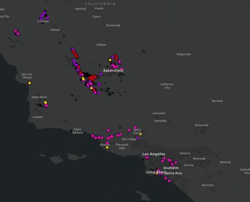 https://www.fractracker.org/a5ej20sjfwe/wp-content/uploads/2023/01/CalGEM-Q4-2022-Permit-Review.jpg
570
1500
Kyle Ferrar, MPH
https://www.fractracker.org/a5ej20sjfwe/wp-content/uploads/2025/09/2025-Wordmark-Logo.png
Kyle Ferrar, MPH2023-01-18 18:01:532023-01-18 18:03:23CalGEM Permit Review Q4 2022: Oil Permit Approvals Show Steep Rise Within Protective Buffer Zones
https://www.fractracker.org/a5ej20sjfwe/wp-content/uploads/2023/01/CalGEM-Q4-2022-Permit-Review.jpg
570
1500
Kyle Ferrar, MPH
https://www.fractracker.org/a5ej20sjfwe/wp-content/uploads/2025/09/2025-Wordmark-Logo.png
Kyle Ferrar, MPH2023-01-18 18:01:532023-01-18 18:03:23CalGEM Permit Review Q4 2022: Oil Permit Approvals Show Steep Rise Within Protective Buffer Zones![]()
216 Franklin St, Suite 400, Johnstown, PA 15901
Phone: +1 (717) 303-0403 | info@fractracker.org
FracTracker Alliance is a 501(c)3 non-profit: Tax identification number: 80-0844297
