
History
ⓘ This section explores the history of fossil fuel extraction in Allegheny County, tracing its impact from early coal mining to modern shale drilling. Learn how industrial development shaped the region.
History of Fossil Fuels in Allegheny County
The history of Allegheny County, Pennsylvania is intertwined with that of resource extraction. Many visitors to the area may be unaware that Pittsburgh’s iconic Mount Washington was originally named “Coal Hill,” due to accessible outcroppings of the Pittsburgh coal seam. These and other deposits were already discovered by the time a young George Washington visited on a diplomatic mission, unsuccessfully inviting the French to abandon the disputed region in the buildup to the French and Indian War.
The U.S. petroleum industry got its start in Pennsylvania a little more than a century later. The Drake Well in Titusville, PA is credited as the first commercial oil well drilled in the country. At its peak in the late 19th Century, Pennsylvania wells were producing one third of the world’s oil. Oil and gas took their place alongside coal in fueling industrial development locally and nationally.
Unregulated Growth and its Environmental Legacy
In the early days of oil and gas development there was little to no regulation. It was not uncommon to find wells in the backyards of small urban parcels as additional hydrocarbon deposits were discovered. This was also at a time when pollution ran unchecked. Concerns for public health and the environment that took root in actions like the Clean Air Act and Clean Water Act were not yet present. While the region’s air and water quality is significantly improved from those days, it still lags behind other similar sized metropolitan regions throughout the country, in part due to the legacy of extraction-dependent industries like power plants and steel manufacturing.
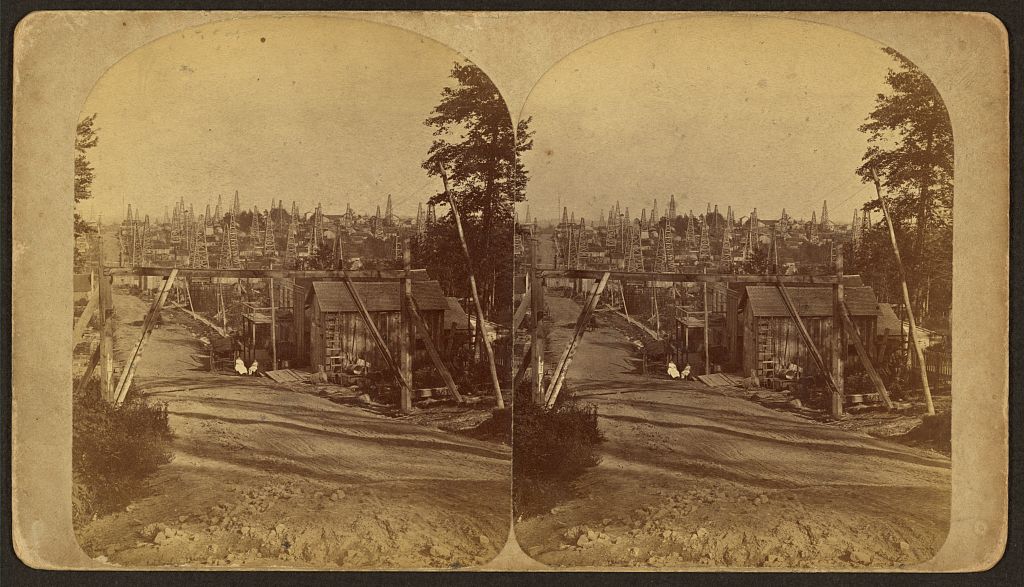
Detail from a Frank Robbins stereographic view of the west side of Triumph Hill, “showing buildings, storage tanks, and derricks, as well as two children sitting in chairs outside a building on Triumph Hill, near Tidioute, Pennsylvania.” (Image Source: Library of Congress)
Marcellus Shale and Expanding Well Sites
Newer “unconventional” oil and gas wells drilled into the Marcellus and other shale formations have slowly encroached upon Allegheny County. There have been 202 of these wells drilled in Allegheny County since December 2008. In comparison, surrounding areas have seen substantially more development—Butler County to the north now has 720 wells; Washington County to the southwest has 2,174. A major difference between historical wells and newer unconventional wells is their scale. Unconventional well pads are major, temporary industrial sites that can exceed five acres in size. Drilling on these sites can also go on for months with multiple wells being hydraulically fractured on a single pad. Millions of gallons of water need to be trucked in, and millions of gallons of waste must be discarded. Flaring of gasses is often required at drill sites, which can produce noise and light pollution for nearby residents. Learn more about this process here.
 Drilling rig in Loyalsock, PA. (Image Source: Peter Stern)
Weighing the Risks and Benefits of Unconventional Wells
Do these risks outweigh potential economic benefits? There are a variety of perspectives on the matter, but many feel that a new fossil fuel energy boom runs counter to the progress that the region has made in recent decades. While in most places regulations are now significantly more robust than they were in the early days of the oil and gas industry, drilling operators often fail to adhere to those standards. As of October 29th, 2024, the Pennsylvania Department of Environmental Protection (DEP) has issued 17,307 violations at unconventional wells.
The Purpose and Utility of Mapping Leases
Regardless of one’s perspective on oil and gas development, we believe it is important for communities to be able to make informed decisions about their future. Municipalities may wish to identify areas where drilling would be particularly burdensome for their residents and limit development through zoning ordinances. Others may wish to enter into dialogue with drilling companies before expensive permitting processes commence. Proactive planning can be difficult with existing tools, however. The PA DEP does publish locations of permitted and drilled wells, but these do not always predict future development. Meanwhile, information that could be used for planning can be largely inaccessible to those without the resources to do exhaustive legal research.
FracTracker’s Lease Mapping Project
FracTracker’s updated Allegheny County Lease Mapping Project provides a comprehensive list of land parcels leased or contracted to oil and gas companies for future development. It is an interactive tool for municipalities, land trusts, and community leaders to utilize when considering their relationships with the oil and gas industry. The project is also intended to assist individuals. For instance, people looking to purchase property may want to take proximity to oil and gas development into consideration alongside other factors like school districts and tax rates. While some may argue that the oil and gas extraction is in a period of dormancy, or even retraction, in Allegheny County, it is important to remember that the industry is cyclical in nature.
We believe the Allegheny County Lease Mapping Project will assist a range of stakeholders in their long-term strategic planning efforts.