Oil Spills in North Dakota: What does DAPL mean for North Dakota’s future?
By Kate van Munster, Data & GIS Intern, and
Kyle Ferrar, Western Program Coordinator, FracTracker Alliance
Pipelines are hailed as the “safest” way to transport crude oil and other refinery products, but federal and state data show that pipeline incidents are common and present major environmental and human health hazards. In light of current events that have green-lighted multiple new pipeline projects, including several that had been previously denied because of the environmental risk they pose, FracTracker Alliance is continuing to focus on pipeline issues.
In this article we look at the record of oil spills, particularly those resulting from pipeline incidents that have occurred in North Dakota, in order to determine the risk presented by the soon-to-be completed Dakota Access Pipeline.
Standing Rock & the DAPL Protest
To give readers a little history on this pipeline, demonstrators in North Dakota, as well as across the country, have been protesting a section of the Dakota Access Pipeline (DAPL) near the Standing Rock Sioux Tribe’s lands since April 2016. The tribe’s momentum has shifted the focus from protests at the build site to legal battles and a march on Washington DC. The pipeline section they are protesting has at this point been largely finished, and is slated to begin pumping oil by April 2017. This final section of pipe crosses under Lake Oahe, a large reservoir created on the Missouri River, just 1.5 miles north of the Standing Rock Sioux Tribal Lands. The tribe has condemned the pipeline because it cuts through sacred land and threatens their environmental and economic well-being by putting their only source for drinking water in jeopardy.
Pipelines
… supposedly safest form of transporting fossil fuels, but …
Pipeline proponents claim that pipelines are the safest method of transporting oil over long distances, whereas transporting oil with trucks has a higher accident and spill rate, and transporting with trains presents a major explosive hazards.
However, what makes one form of land transport safer than the others is dependent on which factor is being taken into account. When considering the costs of human death and property destruction, pipelines are indeed the safest form of land transportation. However, for the amount of oil spilled, pipelines are second-worst, beaten only by trucks. Now, when it comes to environmental impact, pipelines are the worst.
What is not debatable is the fact that pipelines are dangerous, regardless of factor. Between 2010 and October 2016 there was an average of 1.7 pipeline incidents per day across the U.S. according to data from the Pipeline and Hazardous Materials Safety Administration (PHMSA). These incidents have resulted in 100 reported fatalities, 470 injuries, and over $3.4 billion in property damage. More than half of these incidents were caused by equipment failure and corrosion (See Figures 1 and 2).
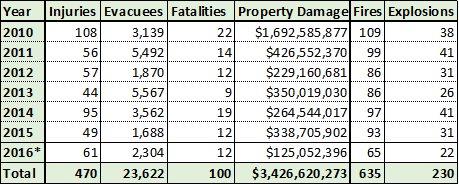
Figure 1. Impacts of pipeline incidents in the US. Data collected from PHMSA on November 4th, 2016 (data through September 2016). Original Analysis
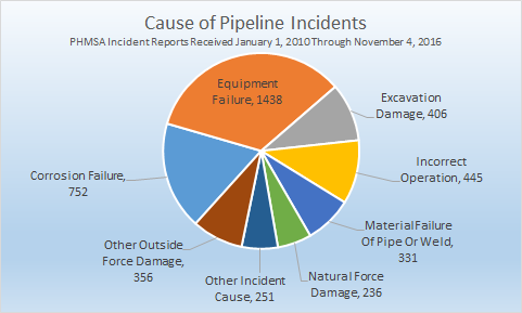
Figure 2. Cause of pipeline incidents for all reports received from January 1, 2010 through November 4, 2016. Original Analysis
Recent Spills in North Dakota
To dig into the risks posed in North Dakota more specifically, let’s take a look at some spill data in the state.
Map 1. Locations of Spills in North Dakota, with volume represented by size of markers
View map fullscreen | How FracTracker maps work
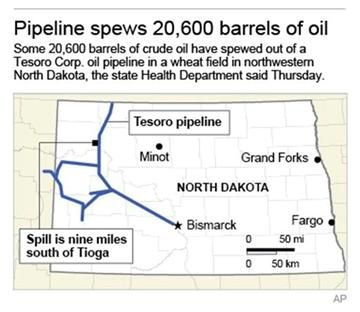
In North Dakota alone there have been 774 oil spill incidents between 2010 and September 2016, spilling an average of 5,131 gallons of oil per incident. The largest spill in North Dakota in recent history, and one of the largest onshore oil spills in the U.S., took place in September 2013. Over 865,000 gallons of crude oil spilled into a wheat field and contaminated about 13 acres. The spill was discovered several days later by the farmer who owns the field, and was not detected by remote monitors. The state claims that no water sources were contaminated and no wildlife were hurt. However, over three years of constant work later, only about one third of the spill has been recovered.
This spill in 2013 may never be fully cleaned up. Cleanup attempts have even included burning away the oil where the spill contaminated wetlands.
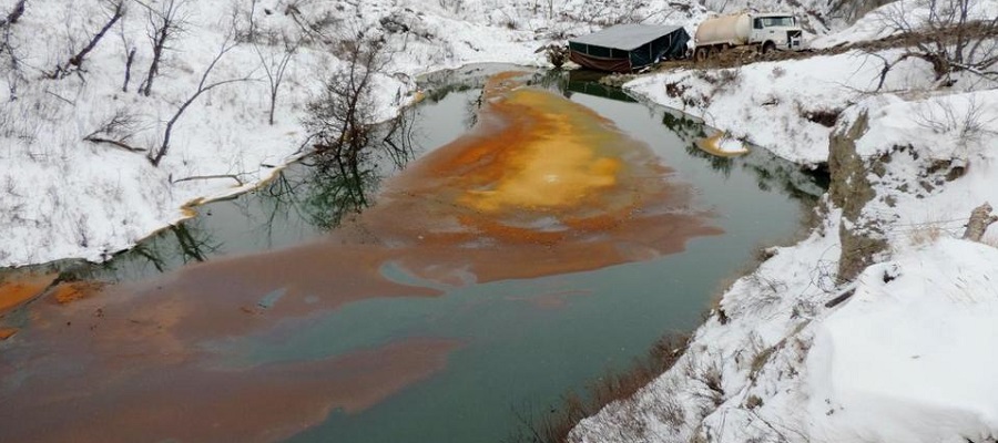
More recently, a pipeline spilled 176,000 gallons of crude oil into a North Dakota stream about 150 miles away from the DAPL protest camps. Electronic monitoring equipment, which is part of a pipeline’s safety precautions, did not detect the leak. Luckily, a landowner discovered the leak on December 5, 2016 before it got worse, and it was quickly contained. However, the spill migrated nearly 6 miles down the Ash Coulee Creek and fouled a number of private and U.S. Forest lands. It has also been difficult to clean up due to snow and sub-zero temperatures.
Even if a spill isn’t as large, it can still have a major effect. In July 2016, 66,000 gallons of heavy oil, mixed with some natural gas, spilled into the North Saskatchewan River in Canada. North Battleford and the city of Prince Albert had to shut off their drinking water intake from the river and were forced to get water from alternate sources. In September, 2 months later, the affected communities were finally able to draw water from the river again.
Toxicology of Oil
Hydrocarbons and other hazardous chemicals
Crude oil is a mixture of various hydrocarbons. Hydrocarbons are compounds that are made primarily of carbon and hydrogen. The most common forms of hydrocarbons in crude oil are paraffins. Crude oil also contains naphthenes and aromatics such as benzene, and many other less common molecules. Crude oil can also contain naturally occurring radioactive materials and trace metals. Many of these compounds are toxic and carcinogenic.
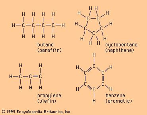
Figure 3. Four common hydrocarbon molecules containing hydrogen (H) and carbon (C). Image from Britannica
Crude oil spills can contaminate surface and groundwater, air, and soil. When a spill is fresh, volatile organic compounds (VOCs), such as benzene, quickly evaporate into the air. Other components of crude oil, such as polycyclic aromatic hydrocarbons (PAHs) can remain in the environment for years and leach into water.
Plants, animals, and people can sustain serious negative physical and biochemical effects when they come in contact with oil spills. People can be exposed to crude oil through skin contact, ingestion, or inhalation. Expsure can irritate the eyes, skin, and respiratory system, and could cause “dizziness, rapid heart rate, headaches, confusion, and anemia.” VOCs can be inhaled and are highly toxic and carcinogenic. PAHs can also be carcinogenic and have been shown to damage fish embryos. When animals are exposed to crude oil, it can damage their liver, blood, and other tissue cells. It can also cause infertility and cancer. Crops exposed to crude oil become less nutritious and are contaminated with carcinogens, radioactive materials, and trace metals. Physically, crude oil can completely cover plants and animals, smothering them and making it hard for animals to stay warm, swim, or fly.
An Analysis of Spills in ND
Below we have analyzed available spill data for North Dakota, including the location and quantity of such incidents.
North Dakota saw an average of 111 crude oil spills per year, or a total of 774 spills from 2010 to October 2016. The greatest number of spills occurred in 2014 with a total of 163. But 2013 had the largest spill with 865,200 gallons and also the highest total volume of oil spilled in one year of 1.3 million gallons. (Table 1)
Table 1. Data on all spills from 2010 through October 2016. Data taken from PHMSA and North Dakota.
| 2010 | 2011 | 2012 | 2013 | 2014 | 2015 | Jan-Oct 2016 | |
| Number of Spills | 55 | 80 | 77 | 126 | 163 | 117 | 156 |
| Total Volume (gallons) | 332,443 | 467,544 | 424,168 | 1,316,910 | 642,521 | 615,695 | 171,888 |
| Ave. Volume/Spill (gallons) | 6,044 | 5,844 | 5,509 | 10,452 | 3,942 | 5,262 | 1,102 |
| Largest Spill (gallons) | 158,928 | 106,050 | 58,758 | 865,200 | 33,600 | 105,000 | 64,863 |
The total volume of oil spilled from 2010 to October 2016 was nearly 4 million gallons, about 2.4 million of which was not contained. Most spills took place at wellheads, but the largest spills occurred along pipelines. (Table 2)
Table 2. Spills by Source. Data taken from PHMSA and North Dakota.
| Wellhead | Vehicle Accident | Storage | Pipeline | Equipment | Uncontained | All Spills | |
| Number of Spills | 694 | 1 | 12 | 54 | 13 | 364 | 774 |
| Total Volume (gallons) | 2,603,652 | 84 | 17,010 | 1,281,798 | 68,623 | 2,394,591 | 3,971,169 |
| Ave. Volume/Spill (gallons) | 3,752 | 84 | 1,418 | 23,737 | 5,279 | 6,579 | 5,131 |
| Largest Spill (gallons) | 106,050 | 84 | 10,416 | 865,200 | 64,863 | 865,200 | 865,200 |
A. Sensitive Areas Impacted
Total Affected Areas (408 linear miles)
Spills that were not contained could potentially affect sensitive lands and waterways in North Dakota. Sensitive areas include Native American Reservations, waterways, drinking water aquifers, parks and wildlife habitat, and cities. Uncontained spill areas overlapped, and potentially contaminated, 5,875 square miles of land and water, and 408 miles of streams.
Drinking Water Aquifers – 2,482.3 total square miles:
- Non-Community Aquifer – 0.3 square miles
- Community Aquifer – 36 square miles of hydrologically connected aquifer
- Surficial Aquifer – 2,446 square miles of hydrologically connected aquifer
A large area of potential drinking water (surficial aquifers) are at risk of contamination. Of the aquifers that are in use, aquifers for community use have larger areas that are potentially contaminated than those for non-community use.
Native American Tribal Reservation
- Fort Berthold, an area of 1,569 square miles
Cities – 67 total square miles
- Berthold
- Dickinson
- Flaxton
- Harwood
- Minot
- Petersburg
- Spring Brook
- Stanley
- West Fargo
Map 2. Areas where Oil Spills Present Public Health Threats
View map fullscreen | How FracTracker maps work
B. Waterways Where Spills Have Occurred
- Floodplains – 73 square miles of interconnected floodplains
- Streams – 408 miles of interconnected streams
- Of the 364 oil spills that have occurred since 2010, 229 (63%) were within 1/4 mile of a waterway
- Of the 61 Uncontained Brine Spills that have occurred since 2001, 38 (63%) were within 1/4 mile of a waterway.
If a spill occurs in a floodplain during or before a flood and is uncontained, the flood waters could disperse the oil over a much larger area. Similarly, contaminated streams can carry oil into larger rivers and lakes. Explore Map 3 for more detail.
Map 3. Oil Spills in North Dakota Waterways
View map fullscreen | How FracTracker maps work
C. Parks & Wildlife Habitat Impacts
Habitat affected
- National Grasslands – on 1,010 square miles of interconnected areas
- United States Wildlife Refuges – 84 square miles of interconnected areas
- North Dakota Wildlife Management Areas – 24 square miles of interconnected areas
- Critical Habitat for Endangered Species – 566 square miles of interconnected areas
The endangered species most affected by spills in North Dakota is the Piping Plover. Explore Map 4 for more detail.
Map 4. Wildlife Areas Impacted by Oil Spills
View map fullscreen | How FracTracker maps work
Methods
Using ArcGIS software, uncontained spill locations were overlaid on spatial datasets of floodplains, stream beds, groundwater regions, sensitive habitats, and other sensitive regions.
The average extent (distance) spilled oil traveled from uncontained spill sites was calculated to 400 meters. This distance was used as a buffer to approximate contact of waterways, floodplains, drinking water resources, habitat, etc. with uncontained oil spills.
Oil Spills in North Dakota Analysis References:
- North Dakota GIS Hub Data Portal
- Oil and Gas: ArcIMS Viewer
- U.S. Fish and Wildlife Service Environmental Conservation Online System
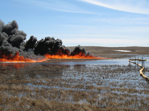
Cover Photo: The site of a December 2016 pipeline spill in North Dakota. Credit: Scott Stockdill/North Dakota Department of Health via AP
Could you possibly revise the the section on ND impacts for clarity about whether the impacts cited are from the 54 pipeline spills or 774 total spills of the study period.,
Thanks for a fabulous resource!