Falcon Pipeline: Cumulative Development & Compounded Risks
Part of the Falcon Public EIA Project
In this final section of the Falcon Public EIA Project, we explore the Falcon pipeline’s entanglements with a region already impacted by a long history of energy development. Featured in this article are where the Falcon pipeline intersects underground mining facilities, strip mines, other hazardous pipelines, active oil and gas wells, as well as a very large compressor station. We utilize this information to locate spaces where cumulative development also has the potential for compounded risk.
Quick Falcon Facts
Map of Falcon relative to mined areas and other energy-related development
The following map will serve as our guide in breaking down where the Falcon intersects areas that have experienced other forms of energy development. Expand the map full-screen to explore its contents in greater depth. Some layers only become visible as you zoom in. A number of additional features of the map are not shown by default, but can be turned on in the “layers” tab. These include information on geological features, water tables, soil erosion characteristics, as well as drinking reservoir boundaries. Click the “details” tab in full-screen mode to read how the different layers were created.
View Map Fullscreen | How FracTracker Maps Work
Mined Lands
The Falcon pipeline intersects a surprising number of active and inactive/abandoned mine lands. While the location of active mines is fairly easy to obtain from mine operators, finding data on abandoned mines is notoriously difficult. State agencies, such as the Pennsylvania Department of Environmental Protection (DEP), have digitized many legacy maps, but these resources are known to be incomplete and inaccurate in many locations.
AECOM’s engineers used data layers on active and abandoned mine lands maintained by state agencies in OH, WV, and PA. FracTracker obtained this data, as well, as shown on the interactive map. Shell states in their permits that AECOM’s engineers also went through a process of obtaining and digitizing paper maps in areas with questionable mine maps.
![]() Shell states that their analysis shows that 16.8 miles of the Falcon pipeline travel through under-mined areas. Our analysis using the same dataset suggests the figure is closer to 20 miles. Of these 20 miles of pipeline:
Shell states that their analysis shows that 16.8 miles of the Falcon pipeline travel through under-mined areas. Our analysis using the same dataset suggests the figure is closer to 20 miles. Of these 20 miles of pipeline:
- 5.6 miles run through active coal mines and are located in Cadiz Township, OH (Harrison Mining Co. Nelms Mine); Ross Township, OH (Rosebud Mining Co. Deep Mine 10); and in Greene Township, PA (Rosebud Mining Co. Beaver Valley Mine).
- More than 18 miles run through areas that have been historically surface-mined (some overlapping under-mined areas).
- Of those 18 miles, 1.5 miles run through an active surface mine located in Cadiz Township, OH, managed by Oxford Mining Company.
Beaver Valley Mine
The Beaver Valley Mine in Greene Township, PA, appeared to be of particular importance in Shell’s analysis. Of the three active mines, Shell maintained an active data layer with the mine’s underground cell map for reference in selecting routes, seen in the image below. Note how the current route changed since the map was originally digitized, indicating that a shift was made to accommodate areas around the mine. The FracTracker interactive map shows the mine based on PA DEP data, which is not as precise as the mine map AECOM obtained from Rosebud Mining.

![]() Rosebud Mining idled its Beaver Valley Mine in 2016 due to declining demand for coal. However, Rosebud appears to be expanding its workforce at other mines in the area due to changing economic and political circumstances. We don’t know exactly why this particular mine was highlighted in Shell’s analysis, or why the route shifted, as it is not directly addressed in Shell’s permit applications. Possibilities include needing to plan around areas that are known to be unfit for the pipeline, but also perhaps areas that may be mined in the future if the Beaver Valley Mine were to restart operations.
Rosebud Mining idled its Beaver Valley Mine in 2016 due to declining demand for coal. However, Rosebud appears to be expanding its workforce at other mines in the area due to changing economic and political circumstances. We don’t know exactly why this particular mine was highlighted in Shell’s analysis, or why the route shifted, as it is not directly addressed in Shell’s permit applications. Possibilities include needing to plan around areas that are known to be unfit for the pipeline, but also perhaps areas that may be mined in the future if the Beaver Valley Mine were to restart operations.
Coal Slurry Site, Imperial PA
As discussed in other segments of the Falcon Public EIA Project, Shell intends to execute 19 horizontal directional drilling (HDD) operations at different sites along the pipeline. A cluster of these are located in Allegheny and Washington counties, PA, with extensive historical surface mining operations. A 2003 DEP report commented on this region, stating:
All of the coal has been underground mined. Most of the coal ribs and stumps (remnants from the abandoned underground mine) have been surface mined… The extensive deep mining, which took place from the 1920’s through the 1950’s, has had a severe effect on groundwater and surface water in this watershed.
![]() Shell’s applications note that AECOM did geotechnical survey work in this and other surface-mined areas co-located with proposed HDD operations, concluding that the ”majority of rock encountered was shale, sandstone, limestone, and claystone.” However, at one proposed HDD (called “HOU-06”) the Falcon will cross a coal waste site identified in the permits as “Imperial Land Coal Slurry” along with a large Palustrine Emergent (PEM) wetland along Potato Garden Run, seen below.
Shell’s applications note that AECOM did geotechnical survey work in this and other surface-mined areas co-located with proposed HDD operations, concluding that the ”majority of rock encountered was shale, sandstone, limestone, and claystone.” However, at one proposed HDD (called “HOU-06”) the Falcon will cross a coal waste site identified in the permits as “Imperial Land Coal Slurry” along with a large Palustrine Emergent (PEM) wetland along Potato Garden Run, seen below.

Foreign Pipelines
In addition to its entanglements with legacy coal mining, the Falcon will be built in a region heavily traveled by oil and gas pipelines. More than 260 “foreign pipelines” carrying oil, natural gas, and natural gas liquids, were identified by AECOM engineers when selecting the Falcon’s right-of-way (note that not all of these are directly crossed by the Falcon).
Owners of these pipelines run the gamut, including companies such as Williams, MarkWest, Columbia, Kinder Morgan, Energy Transfer Partners, Momentum, Peoples Gas, Chesapeake, and Range Resources. Their purposes are also varied. Some are gathering lines that move oil and gas from well pads, others are midstream lines connecting things like compressor stations to processing plants, others still are distribution lines that eventually bring gas to homes and businesses. FracTracker took note of these numbers and their significance, but did not have the capacity to document all of them for our interactive map.
Shared Rights-of-Way
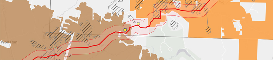
However, we did include one pipeline, the Mariner West, because of its importance in the Falcon’s construction plans. Mariner West was built in 2011-2013 as part of an expanding network of pipelines initially owned by Sunoco Pipeline but now operated by Energy Transfer Partners. The 10-inch pipeline transports 50,000 barrels of ethane per day from the Separator plant in Houston, PA, to processing facilities in Canada. Another spur in this network is the controversial Mariner East 2.
Mariner West is pertinent to the Falcon because the two pipelines will share the same right-of-way through a 4-mile stretch of Beaver County, PA, as shown below.

Reuse of existing rights-of-way is generally considered advantageous by pipeline operators and regulatory agencies. The logistics of sharing pipelines can be complicated, however. As noted in Shell’s permit applications:
Construction coordination will be essential on the project due to the numerous parties involved and the close proximity to other utilities. Accurate line location was completed; however, verification will also be key, along with obtaining proper crossing design techniques from the foreign utilities. A meeting with all of pipeline companies will be held to make sure that all of the restrictions are understood prior to starting construction, and that they are documented on the construction alignment sheets/bid documents for the contractor(s). This will save a potential delay in the project. It will also make working around the existing pipelines safe.
![]() Shell’s attention to coordinating with other utility companies is no doubt important, as is their recognition of working near existing pipelines as a safety issue. There are elevated risks with co-located pipelines when they come into operation. This was seen in a major pipeline accident in Salem Township, PA, in 2016. One natural gas line exploded, destroying nearby homes, and damaged three adjacent pipelines that took more than a year to come back online. These findings raise the question of whether or not Class Location and High Consequence Area assessments for the Falcon should factor for the exponential risks of sharing a right-of-way with Mariner West.
Shell’s attention to coordinating with other utility companies is no doubt important, as is their recognition of working near existing pipelines as a safety issue. There are elevated risks with co-located pipelines when they come into operation. This was seen in a major pipeline accident in Salem Township, PA, in 2016. One natural gas line exploded, destroying nearby homes, and damaged three adjacent pipelines that took more than a year to come back online. These findings raise the question of whether or not Class Location and High Consequence Area assessments for the Falcon should factor for the exponential risks of sharing a right-of-way with Mariner West.
Oil & Gas Extraction
The remaining features included on our map relate to oil and gas extraction activities. The Falcon will carry ethane from the three cryogenic separator plants at the pipeline’s source points. But the wet, fracked gas that supplies those plants also comes from someplace, and these are the many thousands of unconventional gas wells spread across the Marcellus and Utica shale.
![]() We found 11 unconventional oil and gas pads, hosting a combined 48 well heads, within the Falcon’s 940-foot PIR. We also found a large compressor station operated by Range Resources, located in Robinson Township, PA. This is shown below, along with a nearby gas pad.
We found 11 unconventional oil and gas pads, hosting a combined 48 well heads, within the Falcon’s 940-foot PIR. We also found a large compressor station operated by Range Resources, located in Robinson Township, PA. This is shown below, along with a nearby gas pad.

We noted these well pads and the compressor station because Class Location and HCA risk analysis may account for proximity to occupied businesses and homes, but does not always consider a pipeline’s proximity to other high-risk industrial sites. Nevertheless, serious incidents have occurred at well pads and processing facilities that could implicate nearby hazardous liquid pipelines. By the same measure, an accident with the Falcon could implicate one of these facilities, given they are all within the Falcon’s blast zone.
* * *
Trackbacks & Pingbacks
[…] Falcon Pipeline: Cumulative Development & Compounded Risks […]
Comments are closed.