Speaker: Sandra Steingraber – “Morgan Lecturer”
World Renowned Ecologist, Author and Cancer Survivor
A reception and book signing will follow.
New Date! February 3, 2011 — 7pm Dickinson College, Anita Tuvin Schlechter Auditorium, Carlisle, PA
In this lecture, Steingraber will explore the tangled relationship between petrochemicals and farming, with a special focus on how the extraction of natural gas from shale bedrock threatens the ecological conditions of our food system.
The event is co-sponsored by the Women’s Center, the Office of Institutional and Diversity Initiatives, and the Departments of Biology, American Studies and Environmental Studies.
Biography (provided by the speaker)
A world renowned ecologist, Sandra Steingraber is an expert on the links between cancer and the environment; reforming chemical policy and contamination without consent.
Ecologist, author, and cancer survivor, Sandra Steingraber, Ph.D. is an internationally recognized expert on the environmental links to cancer and human health. Steingraber’s highly acclaimed book, Living Downstream: An Ecologist’s Personal Investigation of Cancer and the Environment presents cancer as a human rights issue. Originally published in 1997, it was the first to bring together data on toxic releases with data from U.S. cancer registries. Read more.
The Clarke Forum’s Annual Theme
Each year The Clarke Forum devotes a major portion of its resources to activities organized around an annual theme. All members of the Dickinson community, including students, are invited to propose topics for annual themes. Annual themes have included: Democratization, Race & Ethnicity, The Politics of Identity, Environmental Sustainability, Citizenship, Corporations & Globalization, War, Crossing Borders, For Richer or for Poorer: Globalization under Attack, Religion and Political Power, Energy, A Gendered World and Human Rights. The theme for 2010-11 is Thought for Food.
https://www.fractracker.org/a5ej20sjfwe/wp-content/uploads/2025/09/2025-Wordmark-Logo.png00FracTracker Alliancehttps://www.fractracker.org/a5ej20sjfwe/wp-content/uploads/2025/09/2025-Wordmark-Logo.pngFracTracker Alliance2011-01-11 18:11:002020-07-21 10:36:59Upcoming Event: “Fracking” Our Food: A New Threat to Sustainable Farming
In response to separate incidents, the Pennsylvania Department of Environmental Protection (DEP) issued fines to two of the larger natural gas companies in the Commonwealth: Talisman Energy USA, Inc. and a subsidiary of Chief Oil and Gas.
Talisman’s $24,608 fine was announced on January 6, 2011 in reaction to a large diesel spill at a Marcellus Shale site. According to the DEP, the March 2010 spill contaminated 3,800 tons of soil and 132,000 gallons of water.
Chief Gathering LLC, a subsidiary of Chief Oil and Gas, was fined a $34,000 for illegally discharging hydrostatic water on August 11, 2010. According to the DEP report, hydrostatic water is used to test for leaks in gas pipelines before they are used for gas. There were five related violations with the incident, including:
Failure to minimize the flow rate from the discharge point and allowing the formation of a 150-foot erosion channel
Failure to submit accurate, detailed Notice of Intent project information
Discharging hydrostatic test water with a total chlorine residual greater than 0.05 parts per million
Allowing an unknown industrial waste to co-mingle in five storage tanks with the hydrostatic test water, which was subsequently discharged
A failure to monitor the discharge for the specified effluent parameters at the minimum frequency required.
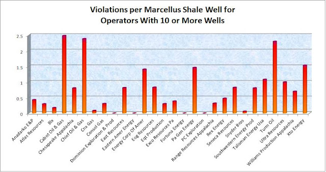
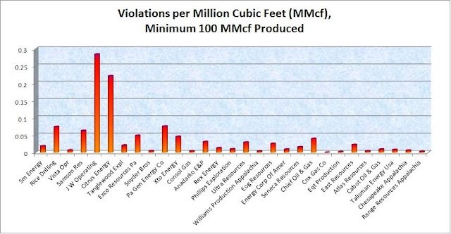
In my earlier analysis of violations per drilling operator, both of these companies were fairly high in terms of violations per well, but relatively low in terms of violations per million cubic feet of natural gas produced.
Violations per million cubic feet (MMcf) of natural gas produced, All violations are from 1-1-07 to 9-30-10, while all production values are from 7-1-09 to 6-30-10.
https://www.fractracker.org/a5ej20sjfwe/wp-content/uploads/2025/09/2025-Wordmark-Logo.png00Matt Kelso, BAhttps://www.fractracker.org/a5ej20sjfwe/wp-content/uploads/2025/09/2025-Wordmark-Logo.pngMatt Kelso, BA2011-01-10 15:56:002020-07-21 10:36:25Talisman and Chief Fined by DEP
Jim Riggio, plant manager for the Beaver Falls Municipal
Authority, shows a sample of solid materials removed from
the Beaver River during treatment Dec. 15 at his plant.
On January 3rd, Associated Press writer, David Caruso, criticized the efforts underway in Pennsylvania to protect surface waters from shale gas drilling wastewater – especially because in most other states the primary means of disposal is deep well injection.
On January 4th, both the Marcellus Shale Coalition (the industry’s PR group) and DEP Secretary John Hanger defended the Commonwealth’s actions and current regulations.
What do you think?
Do you want to know where shale gas wastewater is permitted to be disposed of into surface waters near you? Below is a snapshot that I made in August 2010 using FracTracker’s DataTool of the facilities within PA that are permitted to receive shale gas drilling wastewater:
To learn more about a particular site, click on the inspect button in the gray toolbar – the “i” – and then click on a red diamond. A white box will pop up. Within that box, click on “view” to see who operates these facilities and how much wastewater per day they are permitted to receive. (“MGD” stands for Million Gallons Per Day. “GPD” means Gallons Per Day.)
And finally, here are two blog posts written by CHEC staff about the challenges facing our surface waters – and potentially our health – as a result of both fresh water withdrawals and wasterwater disposal:
https://www.fractracker.org/a5ej20sjfwe/wp-content/uploads/2025/09/2025-Wordmark-Logo.png00FracTracker Alliancehttps://www.fractracker.org/a5ej20sjfwe/wp-content/uploads/2025/09/2025-Wordmark-Logo.pngFracTracker Alliance2011-01-07 16:50:002020-07-21 10:36:25How is PA handling shale gas wastewater?
Most of what I post on this site has to do with numbers: Pennsylvania’s 9,370 violations in less than four years; which drilling operators have the most violations per well; Marcellus Shale wells are 1.5 to 4 times more likely to have violations than conventional wells; and so on.
But of course, numbers only tell part of the story of the impact of gas drilling. It doesn’t really even begin to explain what a single violation means to people who live near these wells. The best way to get that qualitative information is to read the stories of the people who live there. What follows is a first-hand account from Bonnie Burnett of Bradford, PA.
To Whom It May Concern or Who Cares:
My husband and I own a little farm (125 acres) we planned to retire on in Granville Summit, Bradford County, PA. In March of 2009, when the drilling started in Bradford County, there were 2 spills on a well pad next to our property, that rushed down the hill side into our pond, killing all the fish and aquatic life. A deadly swath was carved from the drilling pad to our pond, killing everything. Big old oak trees to tiny peppermint plants that we planted.
A little history: Before Chesapeake started drilling my husband wrote to DEP and asked them the protect our little pond and our property. We saw how they were installing the drilling pad, cutting down over 5 acres of forest and trying to burn the stumps, to no avail, then burying the unburned stumps. Hauling tons of fill and crushed stone to make the pad…..on and on.
Then there was an fracking spill, all noted and recorded -(Chesapeake called it a
human error) causing about 50,000 gallon of second hand fracking water to flow through the woods, downslope into our pond and over the breast of the pond, down into the wetland and into the little creek that flows into the town of Towanda. Two weeks later there was an acid spill of approximately 600 gallons of hydrocholoric acid, all noted and recorded, that again flowed through the pad and seeped through the woods and into our pond. I’m not sure if they labeled this a human error or an accident!
From that date to today, after every rain event water from their pad flows into our pond. On 12/2/10 after a rain storm, water from their pad was flowing across their property into our pond at approximately 95 gal per min., as per their engineer report. After hundreds of telephone calls, on our part, and meetings with Chesapeake and a lot of promises-guess what-it’s winter and the ground and pond is frozen. To top it all off, our well water has been contaminated also. DEP send us a letter and told us not to ingest our well water. Oh well. Chesapeake is making money and the politicians are lining their pockets and are happy and OUR (your and mine) water is being contaminated!!!! I don’t know how old you are and I really don’t care, my husband and I are in our 60’s, but my little grandbabies are the ones I am really concerned about. If the water is
contaminated there will be no life. No one seems to understand that. Life needs water!!
By the way, my husband has had several meetings with DEP, EPA, CNN, CBS, the BBC, PBC (you can find them all on the internet) Guess what-they all say the same thing- This can’t be happening! I’m one of the first ones to admit, I do NOT want more rules and regulations from the government. However, when a big powerful money laden company comes and starts to destroy our countyside and starts to pollute our water, then it’s time for some regulations. The average AMERICAN, who works and gives everything for our country and wants to be safe, needs to have someone help protect us.
You now know some of the mess we have acquired from a huge money making endeavor, a company that happens to be owned by some foreign country and they are laughing all the way to the bank!!
Respectfully submitted,
Bonnie Burnett
If you or anyone you know has first hand stories about gas drilling, send it to me and I will share it with our readers. We are interested in hearing your stories.
https://www.fractracker.org/a5ej20sjfwe/wp-content/uploads/2025/09/2025-Wordmark-Logo.png00Matt Kelso, BAhttps://www.fractracker.org/a5ej20sjfwe/wp-content/uploads/2025/09/2025-Wordmark-Logo.pngMatt Kelso, BA2011-01-03 12:14:002020-07-21 10:36:25What’s the Impact of One Spill?
This page has been archived. It is provided for historical reference only.
Several new datasets have been added to our DataTool in the past few days, including:
Municipal Waste Operations
AML Point Features
PA Marcellus Well Permits since 2007 (2010-12-16)
Pennsylvania Unemployment
Air Emission Plants
For dynamic, clickable views of the following data, please click on the thumbnails. [links removed]
The “Municipal Waste Operations” dataset includes a variety of data, including the different types of facilities (pictured here) and which locations are in a state of compliance. I was hoping to see which of these facilities accepts residual waste from drilling facilities, but that information does not appear to be included on this list. It still has some use though, because like natural gas drilling, landfills and related facilities contribute are sources of pollution. There are over 2,500 facilities on this list in Pennsylvania.
“AML Point Features” is a list of abandoned mines in Pennsylvania. Abandoned mines could potentially act as a conduit for gas migration into surface waters and aquifers, and also pose a number of health issues in their own right. This dataset contains information on the priority of the threat posed by these abandoned mines (show here) along with dozens of categories of the specific nature of that threat. There are over 11,000 points in this database.
“PA Marcellus Well Permits since 2007 (2010-12-16)” is an update of the previous dataset of permits for Marcellus Shale wells in Pennsylvania. As of December 10, there are over 5,663 records in this dataset. Snapshots made with previous datasets should have updated automatically.
“Pennsylvania Unemployment” contains October 2010 unemployment figures by county in the Commonwealth. These numbers are not seasonally adjusted, and vary greatly by county. A snapshot showing an overlay of the Marcellus Shale formation shows no apparent effect of the industry on unemployment in the state. This dataset was obtained from the US Department of Labor, and is included on FracTracker for comparative purposes.
“Air Emission Plants” includes sites that burn fossil fuels, fuel storage sites, pollution control and monitoring devices, and other related facilities. Like “Municipal Waste Operations”, this dataset contains facilities that contribute to polluting Pennsylvania. There are over 109,000 records in this dataset.
This page has been archived. It is provided for historical reference only.
Especially this time of year, it is easy to see the appeal of the landman. A stranger comes knocking on your door, offering you money for something you didn’t know you had, and that you won’t have to work for. How do you beat that? Regular readers of this space know, though, that there are many problems that can be associated with gas drilling, including explosions, spills, road degradation, property devaluation, and gas migration into streams and aquafers. If operators want to drill on your land, assume that their representative:
Is familiar with the relevant regulations
Has some sort of an idea of what to expect from your land (including how much gas will be produced)
Regulations
While the regulations are available online, this is not the time to try the do it yourself approach. The only way to level the legal playing field is with an informed mineral rights attorney. Should you ever find yourself entertaining a landman’s offer, go get one right away. There could potentially be a lot of money (or a lot of headaches) at stake. Drilling operators in Pennsylvania are required to give the mineral rights owner at least 1/8th of the wellhead price of gas that is produced, but how much would they be willing to spend per acre(1)? That depends on the production that they anticipate from your land.
Production
[media removed] Pennsylvania Marcellus Shale natural gas production interpolation. Please click on the tabs with the compass rose and double carat to remove the gray boxes.
Of course, no one knows exactly how much gas a well will produce until it has been drilled, but that doesn’t mean that the industry is blindly poking holes in the ground. The map above is an interpolation map that estimates the amount of gas that would be produced from the Marcellus Shale at any given point in Pennsylvania. This is based on self-reported production data from drilling operators that was posted on the Pennsylvania DEP website.
I made this map with a process called kriging, which compares the value of points with other points on the map, and interpolates the values of the areas in between dots. Because of this, the closer a projected value (blue to red contour lines) is to a measured value (black dots), the more accurate it is. In this map, there are several “bubbles” that look like high production areas in the middle of the state that are probably misleading, since there are no actual wells nearby (2).
It is probably safe to assume that the industry has more and better data to work with, but even so, some information is better than nothing at all. To effectively use this map, zoom in to the area of interest, click the “i” in the blue circle, and click on the lines on either side of the area in question. A box will pop up with a value, which will be in thousands of cubic feet (Mcf). How much a well on your property would produce is critical in determining whether you would be offered $500 or $5,000 per acre. And for the land owner, it is critical in determining whether or not the whole endeavor is worthwhile at all. After all, why have your peaceful home disturbed by a few months of round-the-clock industry for a couple of hundred bucks? Now that you have some idea of what might be produced from wells on your land, you can get an idea of what you might earn with a royalty calculator.
Violations
It is just a fact that sometimes things go wrong once drilling gets underway. Upon request, the Pennsylvania DEP provided us with a list of 9,370 violations from 2007 to the end of September, 2010. And while who the drilling operator is will tell you something of how likely a violation is, geographically speaking, the wells with a lot of violations are somewhat randomly distributed throughout the Marcellus Shale formation.
[media removed] Number of violations per offending Marcellus Shale well, 1-1-07 through 9-30-10. Please click on the tabs with the compass rose and double chevrons to remove the gray boxes.
The map above includes only the Marcellus Shale gas wells that were issued violations by the DEP in the dataset mentioned above. The number of violations per well range from 1 to 37, with smaller values depicted by small blue circles, while the most outrageous wells are large red circles. Obviously, there are some visible clusters in the southwest and northeast of the Commonwealth, because that is where the most wells are being drilled. But a closer look at the map reveals that wells with a lot of violations are actually fairly randomly distributed, with several of the worst offenders in the less productive central part of Pennsylvania (3).
Summary
The take-home message from these two maps is that while the production of gas from a well on your property can be predicted, wells that cause a lot of problems could happen anywhere. Moreover, there does not seem to be a correlation between the two, as some of the worst offenders are in parts of the Commonwealth where the Marcellus Shale play is relatively unproductive. If you have been approached by the industry’s landmen, then the decision of whether or not to lease is yours. Since the stakes are so high, getting a mineral rights lawyer is essential; if legal counsel seems too expensive, then the lease probably isn’t worth the negative impact of drilling anyway. If you are interested in hearing an offer, estimate the amount of gas that will be produced with the map above, plug the range of numbers into the royalty calculator (4), then decide whether moving forward with a lease is worthwhile for you or not.
There are other factors that can be negotiated, including which geologic formations are included.
This happens because there are two high density areas of production in the state, in the northeast and southwest. When the kriging computation was made, a high density area between these two areas was assumed, because there are not any low density production values in between. In short, it is due to the curve of the Marcellus Shale field in the state.
I actually tried to krig this map as well, but the result was nonsense. It projected Philadelphia to be a high violation area, although the nearest Marcellus Shale well would be hundreds of miles away. This nonsensical map is consistent with a random distribution.
The first royalty calculator that I looked for took itself offline because they noticed sharp decreases in production of natural gas after the first year, and wanted to get a handle on the rates of decline. This would indicate that a gas well might just be a short-term financial windfall, which should be another factor to consider.
https://www.fractracker.org/a5ej20sjfwe/wp-content/uploads/2025/09/2025-Wordmark-Logo.png00Matt Kelso, BAhttps://www.fractracker.org/a5ej20sjfwe/wp-content/uploads/2025/09/2025-Wordmark-Logo.pngMatt Kelso, BA2010-12-14 14:34:002020-07-21 10:36:24When the Landman Comes Knocking
Despite the concerns that shale gas drilling can or has deteriorated our water quality in the Marcellus Shale region, I think it is also important to recognize the incredible efforts underway to improve and protect our water. A few weeks ago, I attended a Marcellus Shale Water Monitoring Programs Meeting hosted by the Somerset Conservation District in Johnstown, PA. Below is a summary of the meeting and future plans.
I want to first thank Melissa Reckner, Director of the Kiski-Conemaugh Stream Team, for coordinating the meeting and allowing me to present during it. One of the points that really struck me about this meeting and the Marcellus Shale drilling boom, in general, is the effect that this industry is having on water monitoring and private well water testing; according to the Pennsylvania Department of Environmental Protection (PADEP), approximately a million households rely on private water supplies. Private wells are not regulated by the U.S. Environmental Protection Agency, however. As a result, private wells can often contain contaminants such as coliform bacteria. Since shale gas drilling has increased in the Commonwealth, we have also seen an increase in the rate that people are testing their private water wells and monitoring surface water quality. Although this is mostly due to how close drilling can occur near drinking water sources and surface waters, as a public health professional, I am just glad to see that people are paying more attention to the quality of their water. Here is additional information about private water wells from the PADEP.
To give you a better idea of the extent of this meeting and the level of interest expressed regarding monitoring PA’s surface waters, below is a portion of the groups represented in the Johnstown Area Heritage Association’s beautiful building that day:
Alliance for Aquatic Resource Monitoring (Dickinson College)
Armstrong Conservation District
Blacklick Creek Watershed Association
Cambria County Conservation District
Cambria County EMA
Center for Healthy Environments and Communities (Univ. of Pgh.)
Concurrent Technology Corp.
Evergreen Conservancy
Foundation for PA Watersheds
Greater Johnstown Water Authority
Johnstown Tribune-Democrat
Kiski-Conemaugh Stream Team
Kiskiminetas Watershed Association
PA Department of Environmental Protection
PA Senior Environmental Corps
Shade Creek Watershed Association
Somerset Conservation District
Southern Alleghenies Conservancy
Southern Alleghenies Resource Conservation and Development Council
Stewardship and Sustainability for Goodness Sake
Stonycreek Conemaugh River Improvement Project
Trout Run Watershed Association
Trout Unlimited
Tubmill Trout Club
United Bowhunters of PA
University of Pittsburgh at Johnstown
The purpose of the meeting was to introduce the various watershed groups and organizations to the options presently available for collecting water monitoring data, ways to store and share that data (where FracTracker’s DataTool came in), and the training programs available to get people started.
ALLARM Volunteer Monitoring Protocol
Jinnie Woodward, Assistant Director of ALLARM – the Alliance for Aquatic Resource Monitoring at Dickinson College, provided a summary of ALLARM and highlighted their Marcellus Shale Gas Extraction Volunteer Monitoring Protocol that debuted in Bradford County this summer. Woodward said the objectives of ALLARM’s Marcellus Shale Monitoring Program are to:
Provide an early detection of contamination in small streams, not rivers, because river dynamics are so variable;
Prevent future environmental impacts through the presence of watchful residents; and
Document stream quality.
The parameters that indicate contamination according to Woodward are: conductivity, Total Dissolved Solids (TDS), Barium, and Strontium. Volunteers can feasibly measure conductivity, TDS, and flow. Conductivity measures the ability of water to pass an electrical current. TDS measures the amount of ions dissolved in water. Monitoring both makes data more usable. Barium and Strontium occur naturally deep underground and are indicators of the presence of Marcellus Shale flowback fluid should it reach surface waters.
Volunteers can also conduct visual assessments of areas where they are monitoring. Visual assessments attempt to identify potential impacts and report suspicious activities. Impacts could include:
Earth Disturbances – at the well pad, storage and staging areas, streams, and access roads. Look for unstable outlets, sediment plumes, and little or no gravel on the roads.
Spills and discharges – Consider odor, discoloration, foam, bubbles, etc.
Water withdrawals, especially in unusually low flow areas – Interestingly, western PA does not have signs posted at streams indicating approved water withdrawal areas.
Gas migration or leakage – Look for bubbling.
ALLARM trains volunteers how to access permits from the PADEP and will help determine monitoring locations based on gas well location and stream access. Learn more about ALLARM’s water monitoring program here [link removed].
Water Quality Monitoring Joint Venture
[image removed]
Somerset Conservation District
Manager Len Lichvar with an
in-stream data logger prior to its
placement in a Somerset County
waterway. (Submitted photo)
Source: Daily American
Len Lichvar, District Manager of the Somerset Conservation District and Eric Null, Aquatic Biologist with the same, spoke of the District’s Water Quality Monitoring Joint Venture, of which the Kiski-Conemaugh Stream Team and United States Geologic Survey (USGS) are primary partners.
Lichvar stated that over a year and a half ago, these partners started conversations on how to monitor Marcellus Shale and other pollution sources in an effort to be proactive, not reactive, and innovative, using technology, as was done decades ago with Abandoned Mine Drainage. These groups decided to utilize in-stream data loggers, manufactured by Solinst. These loggers can collect conductivity, temperature and water level.
While Marcellus Shale drove the initiative, it is useful for other types of pollution, including historic sources and new mines. This project can bring to light other issues and serve as an early warning system. It can also fill in data gaps. Lichvar emphasized the importance of prevention – potentially saving millions of dollars by warding of catastrophe – as opposed to fixing major environmental problems once they occur.
Objectives of the Water Quality Monitoring Joint Venture:
Provide an efficient, continuous water quality monitoring network throughout Somerset County.
Monitor other effects of deep mine seeps, Marcellus Shale drilling, and historic pollution sources.
Establish a publicly accessible database.
The District is obtaining these objectives by:
Deploying continuous recording data loggers.
Strategically placing loggers in areas of known disturbance.
Decreasing the number of volunteers necessary to monitor streams 24/7.
Decreasing hours invested and the cost of monitoring.
Partnering with USGS to incorporate this project with their data collection at water quality stations. (USGS will incorporate the District’s data onto their website and is retrofitting gauging stations in Somerset County to also collect conductivity in real-time.)
Null spoke about the rational for monitoring conductivity, from which TDS can be derived. Mining increases TDS, and Marcellus Shale flowback water has high TDS. Conductivity is a life-limiting factor. Null said coalmine discharges generate conductivity levels between 1,500-10,000 us/cm and that 3,500-5,500 us/cm is most common. He said 10,000 us/cm is the upper limit for freshwater life, but Marcellus Shale flowback water can have conductivity levels of over 50,000 us/cm, 5x the upper limit of freshwater life! Null had a copy of flowback data provided by a gas company. He noted that chlorides are the biggest component and threatens to turn our freshwater streams to saltwater.
The District has an established groundwater monitoring program in which water levels at 16 wells throughout Somerset County are monitored monthly. This year, the District purchased a $1,300 Solinst meter to not only monitor the water levels in these wells, but collect conductivity and temperature readings. The meter can detect slight seepage of TDS if it occurs in the wells.
Benefits of the data loggers:
They can monitor conductivity levels from 0-80,000 us/cm (+/- 20 us/cm), making them very accurate.
They can monitor in time increments of your choice. The District has their loggers set to monitor every 15 minutes, 24/7.
The loggers have a 5-year battery life.
They can store at least 30,000 data sets. The District downloads data every two weeks.
They are small and portable.
Only one person is needed to download data.
One logger might equal the manpower of five volunteers.
Temperature readings can also be used to show if a stream is a coldwater fishery!
The Somerset Conservation District now has eight loggers in its possession, six of which are deployed. The other two will be installed within the next two weeks. They are collecting baseline data. The USGS is retrofitting existing Hydrologic Stations with conductivity probes. There are five USGS stations in Somerset County. Three of them are currently online, streaming conductivity to the USGS website.
Lichvar and Null cautioned that if you see a spike, it could be historic pollution. Investigate the cause or source before ‘crying wolf’. Learn more about the data loggers here [link removed].
Trout Unlimited Marcellus Monitoring Training Program
David Sewak, Trout Unlimited’s Marcellus Shale Field Organizer, then presented. The PA Council of Trout Unlimited worked with ALLARM to create a Coldwater Conservation Corps (CCC), complete with field manuals and trainings.
Sewak is working with Trout Unlimited chapters across the state to host volunteer trainings. The trainings are one-day and include information about:
Marcellus Shale – what it is and where it is.
Erosion and sedimentation, and other issues with the industry that go beyond the well pad(s).
Water usage and land uses (Sewak said a vertical well might use 80,000 gallon of water per well, whereas a horizontal well can use up to 5 million gallons per well.)
Who to contact. Volunteers are not police, but reporters.
Maintain validity.
Safety.
Water monitoring (TDS, pH, temperature, cross sections).
Getting latitude/longitude for each monitoring site.
After lunch, participants receive hands-on training on how to use the equipment provided in each kit. Trout Unlimited chapters that host a training will receive two kits, and additional ones can be purchased for about $300.
Most Marcellus Shale activity is occurring where transmission lines are in place (Tioga and Green Counties). Trout Unlimited wants to get as many people as possible trained. Volunteers who are trained serve as stream stewards by accepting monitoring and surveillance responsibility for one or more stream segments. Each Trout Unlimited chapter should appoint a Marcellus Shale Coordinator who can manage data generated by CCC volunteers and serve as a liaison with Sewak, Deb Nardone, and the PATU environmental committee.
Sewak stated that local action tied into a larger strategy allows personalized inputs to connect to statewide effort. Baseline data are critical! He said data gathered will be synthesized with other data and incorporated into TU’s Conservation Success Index (CSI). Analysis will produce a blueprint for action to conserve fish, fisheries, and coldwater resources.
Upcoming TU trainings:
January 15 at the Winnie Palmer Nature Reserve in Latrobe (Forbes Trail TU)
January 29 in Dubois
February 12 in Washington County
March 19 in Lucinda (Clarion County)
You must pre-register for these trainings. The cost is only $17.50, which is an introductory rate of half the price of an adult TU membership. Volunteers must be TU members for liability reasons. Trout Unlimited will provide a Decision Tree pocket guide that provides guidelines for who (what agency) to approach when problems arise.
Trout Unlimited Chapters are working with counties to monitor Marcellus Shale activities and create more partnerships. At this time, Pennsylvania’s Trout Unlimited is not sharing information and data gathered with other states in Eastern U.S. only because PA is the only state with detailed data and an understanding of the topic.
FracTracker and its Trainings
FracTracker DataTool in use,
displaying pipeline incidents
Jan-July 2010.
(The pop-up box is showing info
about one record on the map.)
I then went on to discuss the features of FracTracker, not just as a data repository but also as a way to share information using maps. Learn more about how the system works by clicking here or visiting the DataTool directly.
The Center for Healthy Environments and Communities (CHEC) is in charge of managing FracTracker – both the blog (this site) and DataTool components. We are also responsible for training people how to use it. If you would like to know how to navigate the blog and DataTool, upload and download data, and visualize that data into snapshots, please contact us! There is no charge to attend or request our training sessions. They typically last 3 hours and can be conducted for groups of 10 to 50 people. Venues must have Internet access so that participants can access the blog and DataTool online. CHEC has conducted training and informational sessions about FracTracker across PA, NY, OH, and WV, so geographic location is not an issue.
You can request a training in your area by contacting me directly: malone@fractracker.org, 412-624-9379. (Email requests preferred.)
https://www.fractracker.org/a5ej20sjfwe/wp-content/uploads/2025/09/2025-Wordmark-Logo.png00FracTracker Alliancehttps://www.fractracker.org/a5ej20sjfwe/wp-content/uploads/2025/09/2025-Wordmark-Logo.pngFracTracker Alliance2010-12-14 11:47:002020-07-21 10:36:24PA Water Quality Monitoring Efforts – A Meeting Summary
This page has been archived. It is provided for historical reference only.
The Delaware River Basin Commission (DRBC) has been preparing to defend the appropriateness of the commission to regulate any “exploratory” gas wells drilled in the Delaware River Basin (DRB). Instead, the gas industry, which was questioning DRBC’s right to oversee such matters, has withdrawn from the hearing scheduled for January 18, 2011. It is not clear yet whether the operator of one of the grandfathered well sites will continue to push for the right to drill exploratory wells in the basin without DRBC oversight.
Expert testimony was provided to the DRBC by Dr. Conrad Dan Volz and several others regarding the potential for exploratory drilling to negatively impact the DRB’s ecosystem. Expert Witnesses for DRBC:
Robert M. Anderson, U.S. Fish & Wildlife Service and Danielle Kreeger, Ph.D., Partnership for the Delaware Estuary
Patrick M. O’Dell, P.E., National Park Service
Erik L. Silldorff, Ph.D., Aquatic Biologist, Delaware River Basin Commission
Bernard W. Sweeney, Ph.D. and John K. Jackson, Ph.D., Stroud Water Research Center
Conrad Daniel Volz, DrPH, MPH, University of Pittsburgh School of Public Health
Their testimonies can be read online in the DRBC report.
https://www.fractracker.org/a5ej20sjfwe/wp-content/uploads/2025/09/2025-Wordmark-Logo.png00FracTracker Alliancehttps://www.fractracker.org/a5ej20sjfwe/wp-content/uploads/2025/09/2025-Wordmark-Logo.pngFracTracker Alliance2010-12-13 13:00:002020-07-21 10:36:24Exploratory Gas Drilling in the Delaware River Basin
This page has been archived. It is provided for historical reference only.
At an event hosted by the Institute for Law and Public Policy of California University of Pennsylvania on Friday, CHEC speakers Dr. Conrad Dan Volz, Dr. Charles Christen, and Samantha Malone, MPH, CPH discussed the various public health and environmental public health concerns regarding shale gas drilling, as well as tools to help people address those concerns.
Learn more by checking out their presentations: Volz | Christen | Malone
https://www.fractracker.org/a5ej20sjfwe/wp-content/uploads/2025/09/2025-Wordmark-Logo.png00FracTracker Alliancehttps://www.fractracker.org/a5ej20sjfwe/wp-content/uploads/2025/09/2025-Wordmark-Logo.pngFracTracker Alliance2010-12-13 11:49:002020-07-21 10:36:24CHEC Discussed Potential Impacts of Shale Gas Extraction at CalU Event
This page has been archived. It is provided for historical reference only.
The Delaware River Basin Commission (DRBC) has written a draft of new legislation to help regulate natural gas extraction that could occur within that agency’s boundary, which includes part of Delaware, New Jersey, New York, and Pennsylvania. If finalized, the new legislation will be known as Article 7, the full draft for which is available here.
What is the DRBC?
“The DRBC is a federal-interstate compact government agency that was formed by concurrent legislation enacted in 1961 by the United States and the four basin states (Pennsylvania, New York, New Jersey, and Delaware). Its five members include the basin state governors and the Division Engineer, North Atlantic Division, U.S. Army Corps of Engineers, who serves as the federal representative. The commission has legal authority over both water quality and water quantity-related issues throughout the basin.”
Summary
In essence, Article 7 will require all natural gas development projects within the basin to obtain approval from that entity, in addition to the regular process that is required by the home state. This will include not only drilling for gas, but also exploratory wells, any well-site activities, and associated water withdrawals and wastewater deposits as well. The Commission already has the authority to protect the waters in the basin from pollution, but since the issues of natural gas and clean and healthy rivers are as complicated as they are fundamental, the new regulations were deemed appropriate.
Since this basin includes some of the far eastern edge of the productive Marcellus Shale gas play in Pennsylvania and New York, the new regulations could have an immediate impact—both on the natural gas industry and the Delaware Basin itself.
Public Comments
Written comments on the proposed Article will be accepted through 5 p.m. March 16, 2011. Three public hearings will be scheduled, and details on those will be posted on the DRBC website as soon as the dates are finalized.
https://www.fractracker.org/a5ej20sjfwe/wp-content/uploads/2025/09/2025-Wordmark-Logo.png00Matt Kelso, BAhttps://www.fractracker.org/a5ej20sjfwe/wp-content/uploads/2025/09/2025-Wordmark-Logo.pngMatt Kelso, BA2010-12-10 18:51:002020-07-21 10:36:23Delaware River Basin Commission Approval to be Needed for Gas Operations