Tag Archive for: Nebraska

Wicked Witch of the Waste

The Great Plains has become the unconventional oil & gas industry’s dumping ground, prompting questions about the security and resilience of the bread basket and the underlying Ogalalla Aquifer

Back in December of 2016, FracTracker analyzed the growing link between injection wells that dispose fracking waste and “induced seismicity” [1], or human-caused earthquakes. Our compiled maps from this analysis (including Figure 1 below) show seismic activity in Kansas and Oklahoma along with Class II injection well volumes up through 2015. 
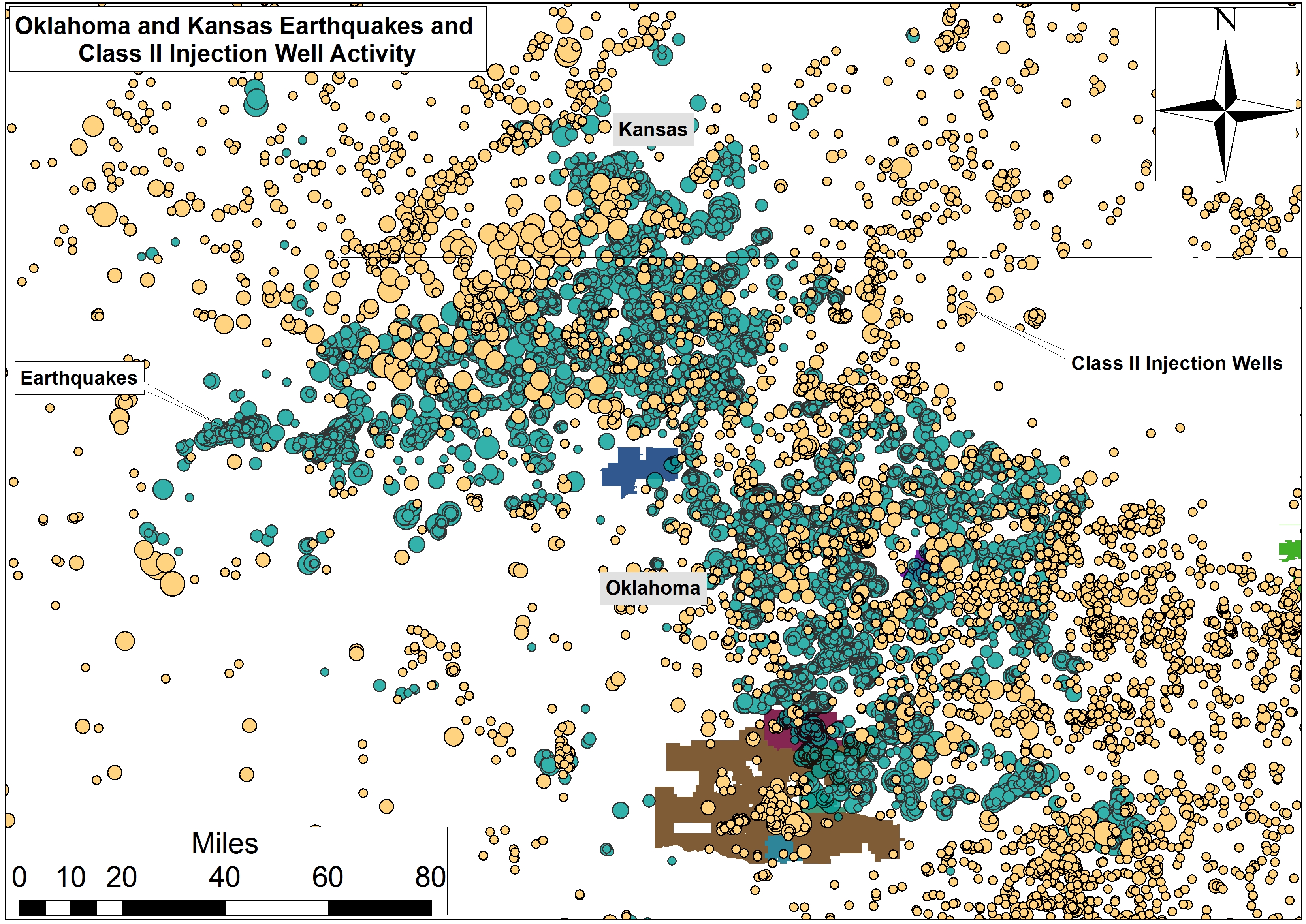
Figure 1. Earthquakes and Class II Injection Well Activity at the Kansas-Oklahoma Border

This link was given acute attention at that time as a result of the magnitude 5.8 earthquake in Pawnee, Oklahoma on September 3rd, 2016, followed closely by a 4.5 earthquake on November 1st.  The industry’s increased production of waste came home to roost 5 days later when a magnitude 5.0 quake struck a mile west of the “Cushing Hub,” the largest commercial crude oil storage center in North America. The Cushing Hub is capable of storing 54 million barrels of crude – the equivalent of 2.8 times the U.S. daily oil refinery capacity and 3.1 times the daily oil refinery capacity of all of North America.

Sunflower State of Affairs

Since we published this analysis and associated maps, Class II injection wells have been in the news several times across the Great Plains. An investigation by KSN News found that the Kansas Corporation Commission (KCC) improperly permitted over 2,000 Class II injection wells. The KCC stated that public comment periods for well proposals lasted just 15 days, instead of the correct number of 30 days. This amounts to 42% and 28% of the state’s active and total inventory of oil and gas waste receiving wells approved with inaccurate public notices.
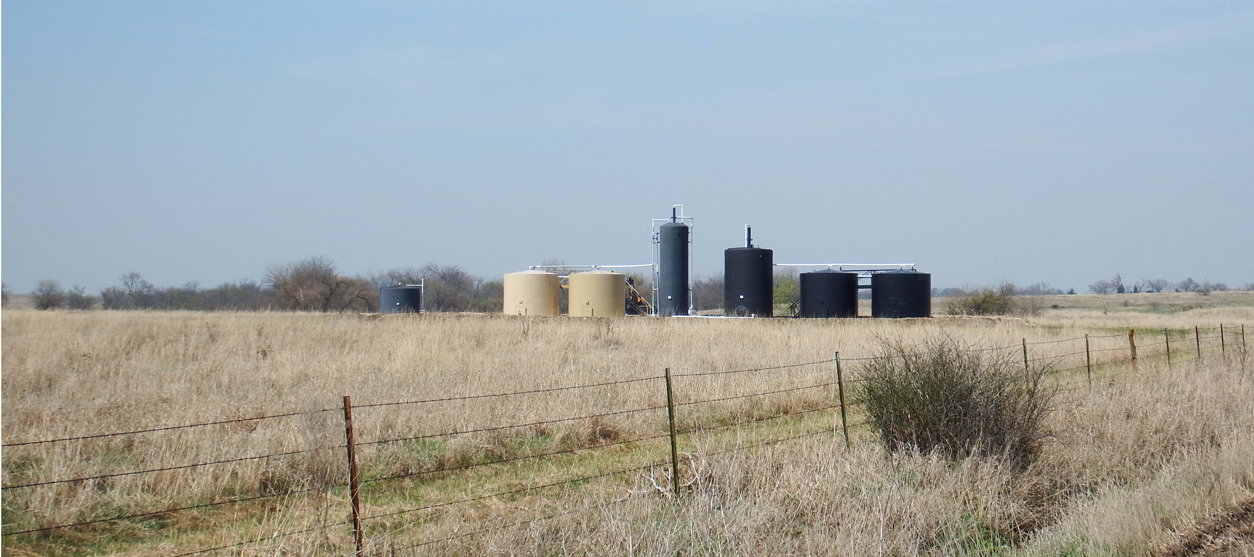

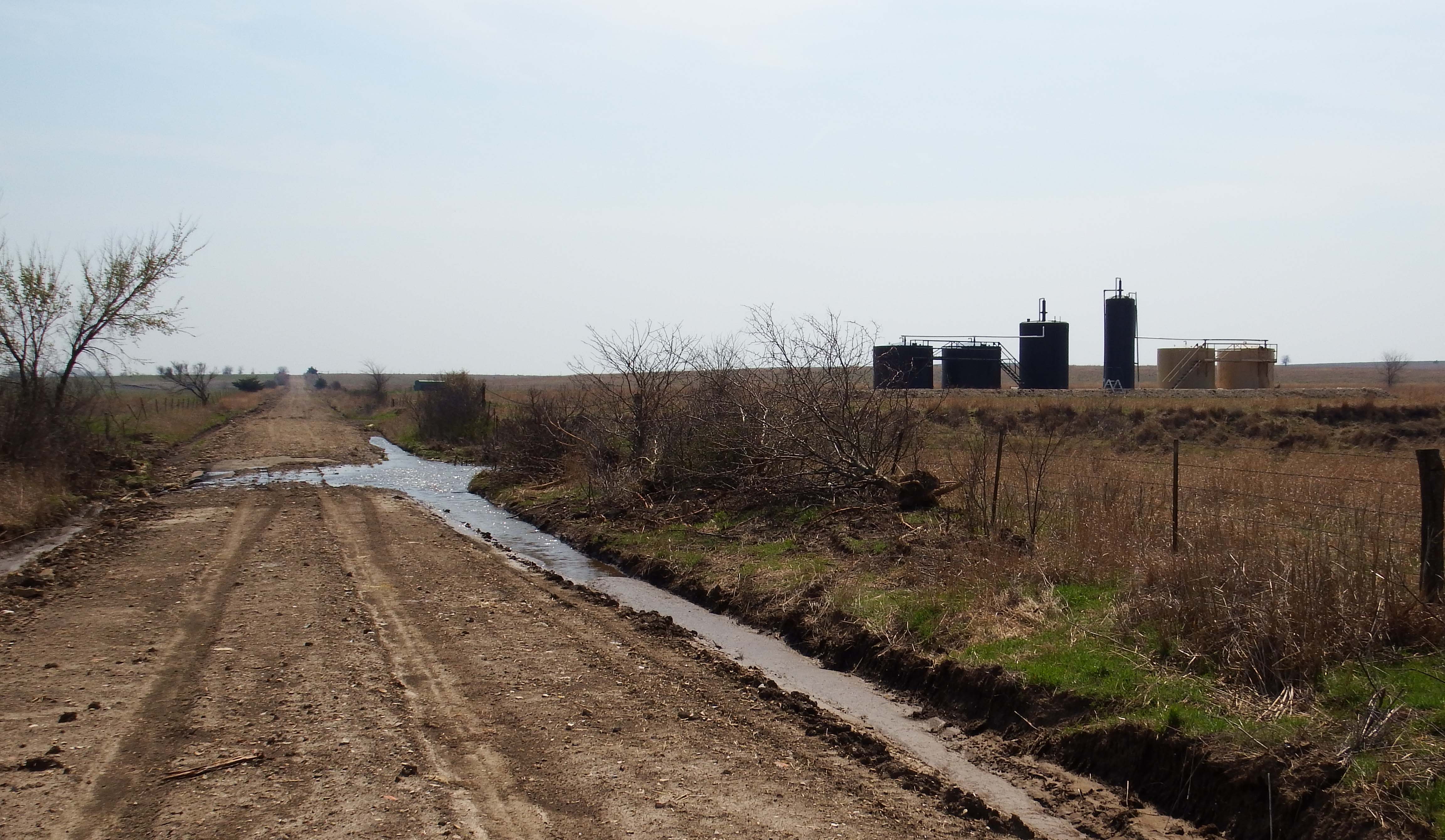
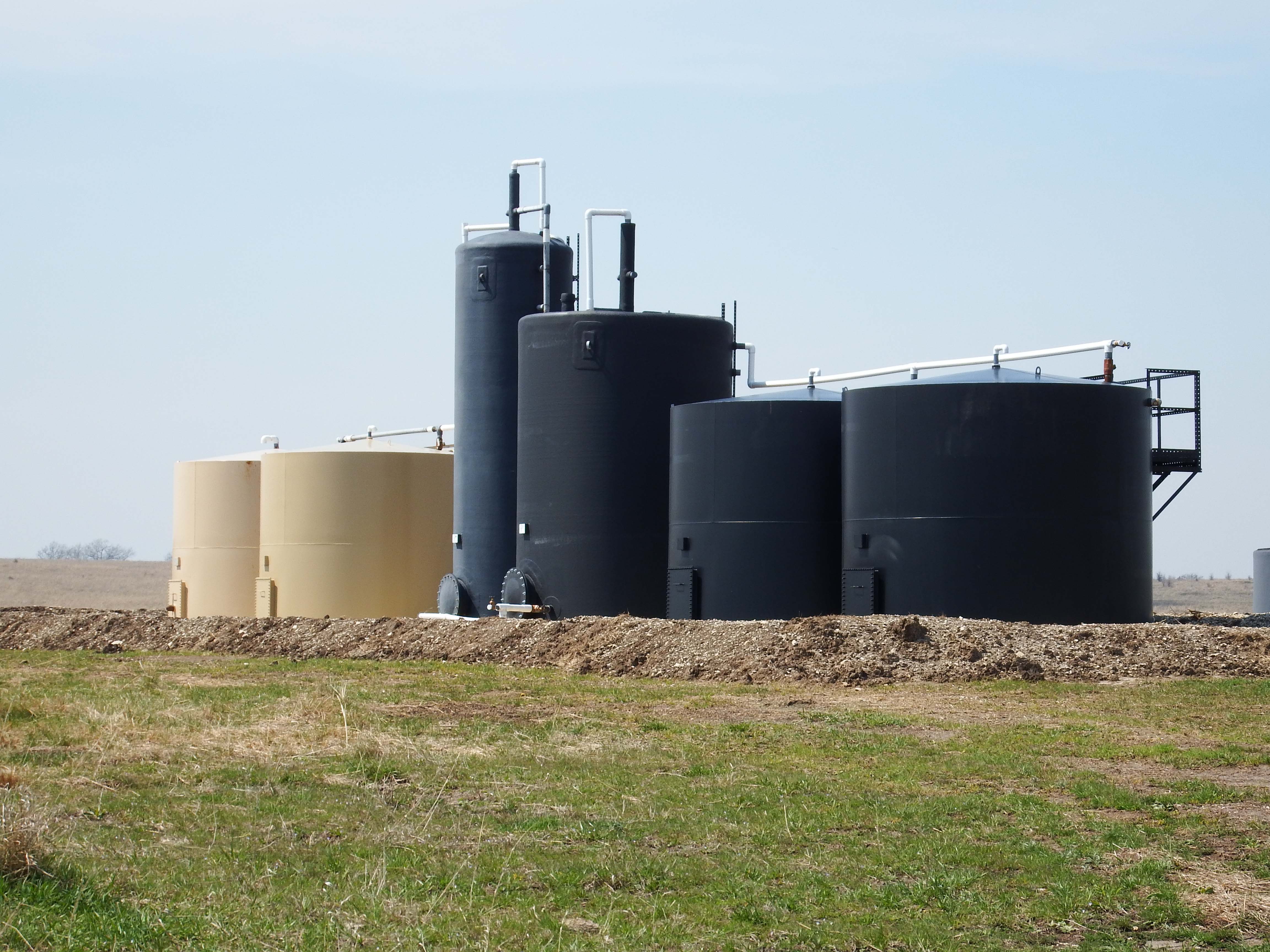
Quail Oil & Gas LC’s Class II Salt Water Disposal (SWD) well, Morris County,
KS near Diamond Creek (Photo Courtesy of Karla jo Grimmett at South 500 photography)

According to Cindy Hoedel, a freelance journalist in Kansas, the KCC responded to the investigation findings… by ruling that no remedy was needed and closing the docket.”

Attorneys representing the Sierra Club maintain that improper permitting by the KCC continued into the Fall of 2018:

“The significance is they are choking us off in terms of giving us less and less time to try to mount a protest, to submit any kind of comment, and that’s a lot,” Cindy Hoedel, a Matfield Green resident who has complained about earthquakes in her area, said… “These notices get published in these tiny little newspapers, and sometimes it might take us 15 days before we find it”

As Ms. Hoedel wrote in an email when I asked her to comment on issues relating to Kansas’ Class II injection wells:

“The Republican controlled Kansas Legislature is trying to fend off several proposed bills that would reform the KCC (the regulatory body that oversees the permitting of Class II underground injection control wells). Citizen challenges of individual applications for disposal and EOR [enhanced oil recovery] wells continue, with the KCC moving more aggressively than in the past to dismiss protestants before a hearing is held. Some of these dismissals are being challenged in appellate court. The activists’ view is that EPA, the SWDA [Safe Water Drinking Act] and Congress clearly intend for the public to be able to participate in the regulatory process; instead, KCC has written regulations that are effectively barriers to participation… Activists have questions about the large number of EOR wells being applied for in Kansas and what their true purpose is, given the insignificant amounts of oil being produced compared to high volumes of injected fluids. Another concern is that the injection well earthquakes in Oklahoma and Kansas continue, yet KCC refuses to add regs that would address seismic risk in permit applications. There is also a problem with harassment of citizens exercising their right to protest – Scott Yeargain and I were both turned in to the Kansas AG’s office by a KCC staffer on the bogus claim that we were practicing law without a license because we helped explain the convoluted process to other protesters.”


Grapes of Wrath

Meanwhile, across the border, Oklahoma City and its surrounding suburbs have become the San Francisco of the Great Plains, with regular earthquake swarms (including many that exceed magnitude 4.0). According to Think Progress reporter Samantha Page, despite the damages and lawsuits caused by these earthquakes, “for years, the state was slow to respond, while Gov. Mary Fallin (R) and others questioned the link to human activity.” 

Eventually, by the end of 2016, the Oklahoma Corporation Commission responded by implementing a ‘traffic light’ protocol, in which operations are paused or stopped altogether following earthquakes of certain magnitudes. For a time, the EPA demanded a moratorium on disposal across Class II wells injecting into the Arbuckle formation in “high seismically active focus areas.”

Chad Warmington, president of the Oklahoma Oil and Gas Association, said that this response by the EPA is “a stellar example of the inefficiency of the federal government…It’s akin to a newspaper telling us today the football scores from games played 15 months ago.”

In reporting on the industry’s response, journalist Paul Monies, buried the lead when he pointed out the following in his second to last paragraph:

“Wastewater recycling remains an expensive option compared to the low costs of disposal wells in Oklahoma. While operators can inject wastewater into formations other than the Arbuckle, Hatfield said other formations don’t accept water as easily and are at shallower depths.”

The Map

Our second stab at mapping the scale and scope of Class II injection wells across the Great Plains is slightly different than our first effort in a few ways:

  1. This iteration includes Class II Salt Water Disposal (SWD) Injection Wells in Nebraska, Oklahoma, and Kansas on one map. Clicking on a well reveals its location, well name, operator, and the volume of wastewater disposed. Volumes are presented annually for Nebraska and monthly for 2011 to 2017 for Oklahoma and Kansas. We also present annual sums for Oklahoma from 2006 to 2010.
  2. The map shows Arkansas and Platte River Basin boundaries, which contain the entire inventory of OK, NE, and KS Class II wells.
  3. We’ve included Hydrologic Unit Codes, which when zoomed in to the map, identify sub-watersheds, and the Ogalalla Aquifer boundary, courtesy of the USGS’s Sharon Qi.
  4. Finally, we’ve includedUS Forest Service Robert G. Bailey’s Ecoregions to give a sense for the types of ecosystems threatened by the O&G industry’s demand for suitable waste disposal sites

View Map Full Screen | To view the legend on this map, click the “layers” icon on the top left of the screen


Table 1, below, breaks down the volumes of oil and gas wastewater disposed in Oklahoma, Kansas and Nebraska. Volumes are measured in million barrels, with one barrel equivalent to 42 gallons. The number of Class II SWD (salt water disposal) injection wells in these states is separated to show the total number of wells permitted verse the number of wells that were active (receiving waste).

Table 1. Class II injection well volumes in 2017
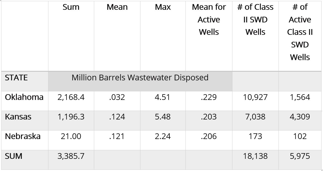
In total, 3,385,700,000 barrels of wastewater were disposed in 5,975 injection wells in these three states in 2017. The volume of wastewater disposed has increased in recent years (Table 2).

Table 2. Cumulative Class II injection well volumes to 2017, annual percent changes, and likely 2018 and 2027 volumes
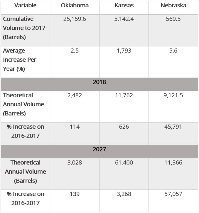
In Table 2, the theoretical annual volumes for 2018 and 2027 are predictions based on the average of linear, exponential, and polynomial models.

The Kansas-Oklahoma Border

It is critical that we analyze the Great Plains fracking waste ecosystem across state lines. There are several reasons for this, including the proximity of Kansas’ most active Class II wells to the Oklahoma border (Figure 2) and the potential for the KCC to use enhanced oil recovery wells in Kansas to dispose of Oklahoma’s fracking waste.
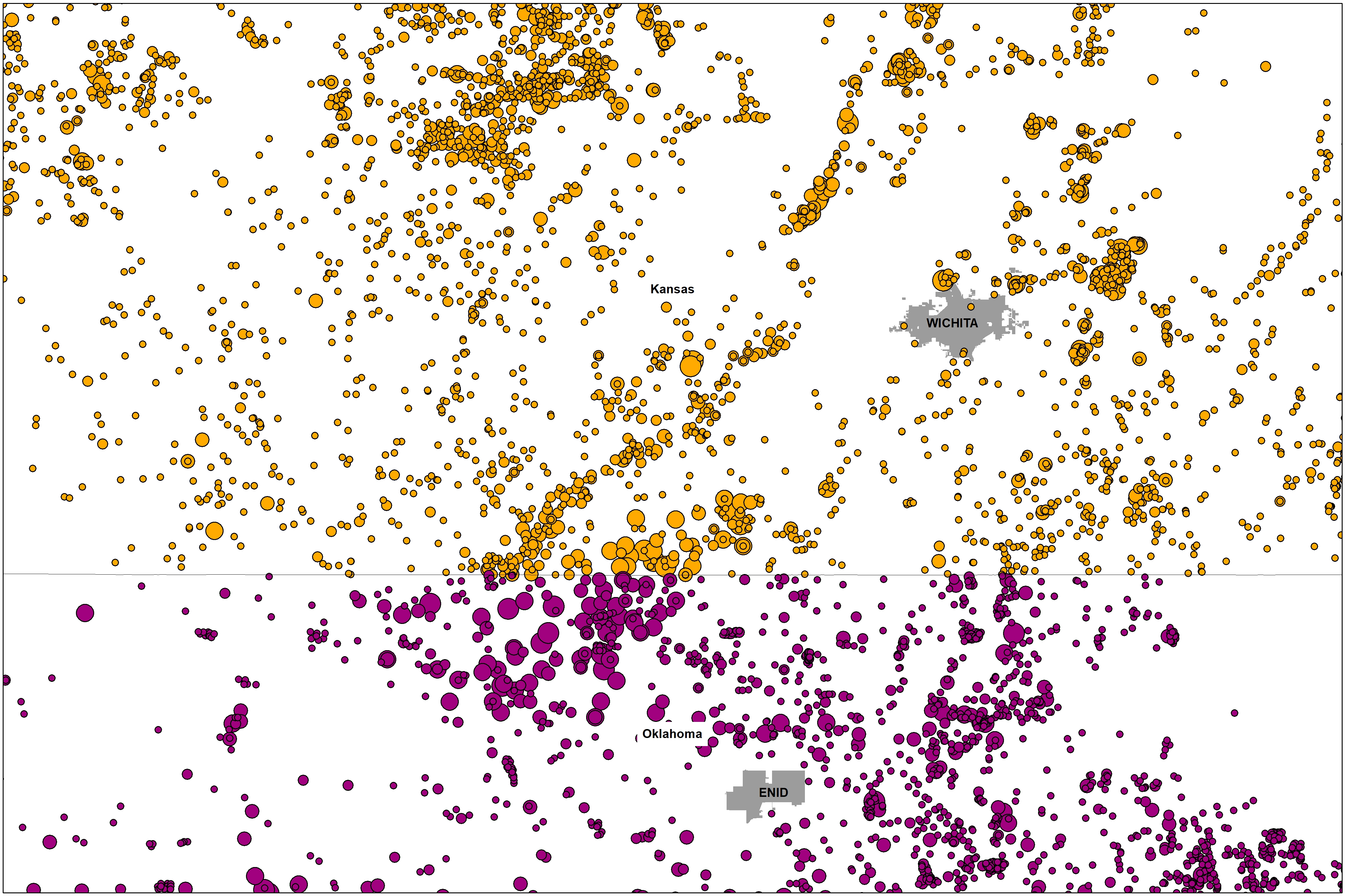
Figure 2. Class II injection well volumes for 2017 along the Kansas-Oklahoma border.

Collaboration between front line communities, non-profits like FracTracker Alliance, and groups like the Kansas Water Advocacy Team (WAT) will be crucial to understanding the impacts of waste disposal writ large.  It seems like the “food vs energy” nexus has come to a head in the heart of the U.S. Bread Basket. We’ll continue to highlight and map the issues associated with this topic in the coming months and years.

Data Download Links

The following links contain the data used in the above tables and map, for use in excel and with Geographic Information Systems (GIS).

[1] To learn more about Induced Seismicity, read an exclusive FracTracker two-part series from former researcher with Virginia Tech Department of Geosciences, Ariel Conn: Part I and Part II.

Additionally, the USGS has created an Induced Earthquakes landing page as part of their Earthquake Hazards Program.
Sandhill Crane

Giving Voice to the Sandhill Cranes: Place-based Arguments against Keystone XL

By Wrexie Bardaglio, guest commentator

When we hear his call, we hear no mere bird. We hear the trumpet in the orchestra of evolution. He is the symbol of our untamable past, of that incredible sweep of millennia which underlies and conditions the daily affairs of birds and men…” ~ Aldo Leopold, on the Sandhill Crane, in “Marshland Elegy”

Dilbit – or diluted bitumen – is refined from the naturally-occurring tar sands deposits in Alberta, Canada. In March 2017, I applied to the Nebraska Public Service Commission for standing as an intervenor in the Commission’s consideration of TransCanada’s request for a permit to construct a pipeline transporting dilbit – a project referred to as the Keystone XL pipeline. Below are my reflections on the battle against the permitting process, and how FracTracker’s maps ensured the Sandhill Crane’s voice made it into public record.

A Pipeline’s History

The Keystone 1 pipeline carries the dilbit from Alberta, to Steele City, Nebraska, and ultimately to Port Arthur, Texas and export refineries along the Gulf Coast. The state of Montana had already approved the Keystone XL project, as had the state of South Dakota. The decision of the South Dakota Public Utilities Commission was appealed, however, and has now worked its way to the South Dakota Supreme Court, where it is pending.

Resistance to TransCanada’s oil and gas infrastructure projects is not new. Beginning in 2010, some Nebraska farmers and ranchers joined forces with tribal nations in the Dakotas, who were also fighting TransCanada’s lack of proper tribal consultation regarding access through traditional treaty territory. The indigenous nations held certain retained rights as agreed in the 1868 Fort Laramie Treaty between the United States government and the nine tribes of the Great Sioux Nation. The tribes were also protesting TransCanada’s flaunting of the National Historic Preservation Act’s protections of Native American sacred sites and burial grounds. Further, although TransCanada was largely successful in securing the easements needed in Nebraska to construct the pipeline, there were local holdouts refusing to negotiate with the company. TransCanada’s subsequent attempts to exercise eminent domain resulted in a number of lawsuits.

In January of 2015, then-President Barack Obama denied the international permit TransCanada needed. While that denial was celebrated by many, everyone also understood that a new president could well restore the international permit. Indeed, as one of his first actions in January 2017, the new Republican president signed an executive order granting the permit, and the struggle in Nebraska was reignited.

“What Waters Run Through My Veins…”

While I am a long-time resident of New York, I grew up in the Platte River Valley of South Central Nebraska, in a town where my family had and continues to have roots – even before Nebraska became a state. There was never a question in my mind that in this particular permitting process I would request status as an intervenor; for me, the matter of the Keystone XL Pipeline went far beyond the legal and political and energy policy questions that were raised and were about to be considered. It was about who I am, how I was raised, what I was taught, what waters run through my veins as surely as blood, and who my own spirit animals are, the Sandhill Cranes.

wrexie_3yrs

Bardaglio (age 3) and her father, along the banks of the Platte River

When we were growing up, our father told us over and over and over about why Nebraska was so green. The Ogallala Aquifer, he said, was deep and vast, and while eight states partially sat atop this ancient natural cistern, nearly all of Nebraska floated on this body. Nebraska was green, its fields stretching to the horizon, because, as our father explained, the snow runoff from the Rockies that flowed into our state and was used eleven times over was cleansed in water-bearing sand and gravel on its way to the Missouri on our eastern boundary, thence to the Mississippi, and finally to the Gulf.

I grew up understanding that the Ogallala Aquifer was a unique treasure, the largest freshwater aquifer in the world, the lifeblood for Nebraska’s agriculture and U.S. agriculture generally, and worthy of protection. I thought about the peril to the aquifer because of TransCanada’s plans, should there be a spill, and the additional threats an accident would potentially pose to Nebraska’s rivers, waterways and private wells.

2000px-ogallala_saturated_thickness_1997-sattk97-v2-svg

The Ogallala Aquifer

Knowing that climate change is real, terrifying, and accelerating, I recognized that a warming world would increasingly depend on this aquifer in the nation’s midsection for life itself.

Migration of the Sandhill Cranes

As I thought about how I would fight the KXL, another narrative took shape rising out of my concern for the aquifer. Growing up in the South Central Platte River Valley, I – and I daresay most everyone who lives there – have been captivated by the annual migration of the Sandhill Cranes, plying the skies known as the Central Flyway. As sure as early spring comes, so do the birds. It may still be bitterly cold, but these birds know that it is time to fly. And so they do – the forward scouts appearing in winter grey skies, soon followed by some 500,000 – 600,000 thousand of them, darkening the skies, their cries deafening and their gorgeous archaeopteryx silhouettes coming in wave after wave like flying Roman Legions.

branch-bird-sky-sunrise-sunset-morning-dawn-flock-dusk-birds-cranes-water-bird-bird-migration-migratory-birds-atmospheric-phenomenon-animal-migration-crane-like-bird-529634

To this day, no matter where I am, the first thing in my sinews and bones when winter begins to give way is the certainty that the birds are coming, I feel them; they are back. They are roosting on the sandbars in the braided river that is the Platte and gleaning in the stubbled fields abutting it… they are home.

According to The Nature Conservancy:

Scientists estimate that at least one-third of the entire North American population of Sandhill Cranes breed in the boreal forest of Canada and Alaska…

Scientists estimate that approximately 80 percent of all Sandhill Cranes in North America use a 75-mile stretch of Nebraska’s Platte River during spring migration. From March to April, more than 500,000 birds spend time in the area preparing for the long journey north to their breeding grounds in Canada and Alaska. During migration, the birds may fly as much as 400 miles in one day.

Sandhill Cranes rely on open freshwater wetlands for most of their lifecycle. Degradation of these kinds of wetland habitats is among the most pressing threats to the survival of Sandhill Cranes. (Emphasis added)

Giving Sandhill Cranes a Voice

But how could I make the point about the threat TransCanada posed to the migratory habitat of the Sandhill Cranes (and endangered Whooping Cranes, pelicans, and hummingbirds among the other thermal riders who also migrate with them)? Books, scientific papers, lectures – all the words in the world – cannot describe this ancient rite, this mysterious primal navigation of the unique pathway focusing on this slim stretch of river, when viewed from a global perspective a fragile skein in a fragile web in a biosphere in peril.

In my head I called it a river of birds in the grassland of sky. And I am so grateful to my friend, Karen Edelstein at FracTracker Alliance, for her willingness to help map and illustrate the magnificence of the migration flyway in the context of the three proposed options for the KXL pipeline.

flyway_map

Karen prepared two maps for me, but my favorite is the one above.

It shows an ancient, near-primordial, near-mystical event. Guided by rudders and instinct we can barely comprehend, in concert with earth’s intrinsic and exquisitely-designed balance, and as certain as a sunrise, a sunset or a moon rise, these oldest of crane species find their ways through the heavens. They hew to certainties that eclipse the greed of multinational corporations like TransCanada, who barely even pay lip service to the integrity of anything over which they can’t exert dominion. To say they don’t respect the inherent rights of species other than our own, or to ecological communities that don’t directly include us, is an understatement, and a damning comment on their values.

I was prepared for pushback on these maps from TransCanada. And in truth, the company was successful in an in limine motion to have certain exhibits and parts of my testimony stricken from the official record of the proceedings.

But not the maps.

In fact, too many other intervenors to count, as well as several of the lawyers involved in the proceedings commented to me on the beauty and accuracy of the maps. And not only are they now a part of the permanent record of the Nebraska Public Service Commission, should there be an appeal (which all of us expect), on both sides of the issue, there is a very good possibility they will be incorporated into the formal testimonies by the lawyers as the matter moves through the appeals process.

Taking Action, Speaking Out

Ordinary citizens must figure out how to confront the near-impenetrable stranglehold of multi-national corporations whose wealth is predicated on the continuance of fossil fuels as the primary sources of energy. We have had to become more educated, more activist, and more determined to fight the destruction that is now assured if we fail to slow down the impacts of climate change and shift the aggregate will of nations towards renewable energy.

Many activists do not realize that they can formally intervene at the state level in pipeline and infrastructure permitting processes. In doing so, the voice of the educated citizen is amplified and becomes a threat to these corporations whose business models didn’t account for systematic and informed resistance in public agencies’ heretofore pro forma proceedings. The publicly-available documents and filings from corporations can be important tools for “speaking truth to power” when paired with the creative tools born of necessity by the environmental movement.

Technology is value-neutral, but as I learned – as did many others in the Keystone XL Pipeline fight – in skilled hands it becomes a weapon in the struggle for the greater good.

I will be forever grateful for FracTracker, and will be interested to see how others use this tool in the fights that are sure to come.

EXCELSIOR!

For more background on the natural history of Sandhill Cranes, please view this video produced by The Crane Trust.


Wrexie Bardaglio is a Nebraska native living in Covert, New York. She worked for ten years for a member of Congress as a legislative assistant with a focus on Indian affairs and for a DC law firm as legislative specialist in Indian affairs. She left politics to open a bookstore in suburban Baltimore. She has been active in the Keystone XL fights in Nebraska and South Dakota and in fracking and gas infrastructure fights in New York.

This article’s feature image of a Sandhill Crane is the work of a U.S. Fish and Wildlife Service employee, taken or made as part of that person’s official duties. As a work of the U.S. federal government, the image is in the public domain.

FracTracker Alliance makes hundreds of maps, analyses, and photos available for free to frontline communities, grassroots groups, NGO’s, and many other organizations concerned about the industry to use in their oil and gas campaigns. To address an issue, you need to be able to see it.

However, we rely on funders and donations – and couldn’t do all of this without your help!