By: C. D. Volz, DrPH, MPH
Director and Principal Investigator of the Center for Healthy Environments and Communities
Is it possible that there will, in the future, be offshore oil and gas platforms in the Great Lakes regions of the United States? The answer is that it has already occurred in Lake Michigan and certainly could be radically expanded with new advances in directional drilling and hydrofracturing of unconventional oil and gas reserves. Oil and gas drilling in the Great Lakes was allowed by the State of Michigan but new drilling was subsequently banned by the state legislature. The issuance of new permits for new drilling in the Great Lakes was banned by the Energy Policy Act of 2005 (P.L. 109- 58, §386). Canadian law though permits onshore oil and gas drilling under the Great Lakes and offshore gas drilling in the Great Lakes (see Congressional Research Service Document, Drilling in the Great Lakes: Background and Issues, 2006.
The U.S. Geological Survey (USGS) completed an assessment of the undiscovered oil and gas potential of the U.S. portions of the Appalachian Basin and the Michigan Basin in 2002 and 2004, respectively The USGS has done an assessment of oil and gas reserves under US portions of the Great Lakes and reports mean levels of recoverable oil, natural gas, and natural gas liquids at 311.71 million barrels of oil (MMBO), 5,228.71 billion cubic feet of gas (BCFG) (equal to 5.228 trillion cubic feet of gas), and 121.68 million barrels of natural gas liquids (M MBNGL), respectively. There have been 8-eight petroleum systems identified underlying United States portions of the Great Lakes. These are the;
Precambrian Nonesuch TPS
Ordovi¬cian Foster TPS
[Ordovician] Utica-Lower Paleozoic TPS
Ordovician to Devonian Composite TPS
Silurian Niagara/Salina TPS
Devonian Antrim TPS
Devonian Shale-Middle and Upper Paleozoic TPS
Pennsylvanian Saginaw TPS.
Each of the above systems is named for the source rock(s) of that system and there is only one source rock for each of the listed systems except the Ordovician to Devonian Composite TPS, which is a composite petroleum system. The Ordovician to Devonian Composite TPS is made up of one or a combination of the following source rocks; the Ordovician Collingwood Shale, Devonian Detroit River Group, and the Devonian Antrim Shale. For more information, see the complete USGS fact sheet, Undiscovered Oil and Gas Resources Underlying the U.S. Portions of the Great Lakes, 2005, Fact Sheet 2006–3049, April 2006.
Extent of the Utica Shale Formation. Click on the gray compass rose to hide the legend.
This FracTracker snapshot of the extent of the Utica Shale shows that it underlays the major extent of Lake Erie and Lake Ontario in both United States and Canada territorial waters.
https://www.fractracker.org/a5ej20sjfwe/wp-content/uploads/2025/09/2025-Wordmark-Logo.png00Guest Authorhttps://www.fractracker.org/a5ej20sjfwe/wp-content/uploads/2025/09/2025-Wordmark-Logo.pngGuest Author2011-02-11 16:02:002020-07-21 10:37:01Oil, Natural Gas, and Natural Gas Fluids Drilling and Production in the Inland United States Waters of the Great Lakes?
By Samantha Malone, MPH, CPH – Communications Specialist, Center for Healthy Environments and Communities of the University of Pittsburgh Graduate School of Public Health (GSPH); Doctoral Student, GSPH
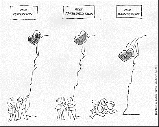
Two reports were issued yesterday by credible sources regarding the safety of natural gas drilling in shale formations. The one was issued by the Pennsylvania Department of Environmental Protection (PA DEP) on the air emissions from natural gas operations. The other by the House Energy Commerce Committee focused on the use of diesel fuel in hydraulic fracturing fluid. While these reports do not contradict one another, they certainly do not contribute to an overall consensus on the public safety of shale gas extraction.
Report 1 – PA Department of Environmental Protection
The PA DEP’s report was based on a four-week air quality study that they conducted in northeastern PA near Marcellus Shale natural gas operations. This report states that the emission levels they surveyed would not constitute a health concern for nearby residents, acknowledging that the study’s purpose was not to address the cumulative impacts that could result from long term exposure.
Report 2 – House Energy and Commerce Committee
The Energy and Commerce Committee within the House of Representatives sent a letter to the Environmental Protection Agency’s Administrator, Lisa Jackson, stating that between ’05 and ’09 oil and gas companies injected over 32 million gallons of diesel fuel or hydraulic fracturing fluids containing diesel fuel in wells in 19 states. This letter noted that at no point in time were these companies officially permitted to use diesel fuel in the hydraulic fracturing process – citing the behavior as a violation of the Safe Drinking Water Act.
The Message
The intention for this post is not to debate whether air contamination is worse than ground or water pollution, whether one report is right/wrong, or to discuss how difficult it is to accurately measure air emissions when companies know when and where you are testing. The true intention of writing this is to stress that the opposing reports only stand to ‘muddy the water’ on America’s viewpoint of the issue. Risk communication is hard enough to do properly without such inconsistency. The fact that these – and many other credible sources – cannot agree on whether natural gas drilling poses an environmental or public health threat further demonstrates that additional, unbiased research should be conducted.
https://www.fractracker.org/a5ej20sjfwe/wp-content/uploads/2025/09/2025-Wordmark-Logo.png00FracTracker Alliancehttps://www.fractracker.org/a5ej20sjfwe/wp-content/uploads/2025/09/2025-Wordmark-Logo.pngFracTracker Alliance2011-02-01 10:09:002020-07-21 10:37:00When Messages are in Opposition, Risk Communication Difficult
By Samantha Malone, MPH, CPH – Communications Specialist, Center for Healthy Environments and Communities (CHEC), University of Pittsburgh Graduate School of Public Health (GSPH); and Doctorate of Public Health (DrPH) Student, GSPH
If done improperly (or in excess), shale gas drilling has the potential to contaminate ambient air, surface water, drinking water, and/or ground water. A healthy agricultural system relies upon all of those media in varying degrees.On any given day, I receive roughly 50 emails from people concerned about the effects of natural gas drilling. Check out this document as an example. The topics of conversation are incredibly diverse, and yet the discussion surrounding the effects that drilling may have on our local farms is occurring more and more frequently. One of the reasons for this ‘boom’ in concern about our farms, in my opinion, is that the scientific evidence that connects drilling and hydraulic fracturing to the potential contamination of the food supply is lacking – while the anecdotal evidence is not.
As a result, people have even begun to compile ‘evidence’ suggesting that drilling has affected local agriculture, or will. I believe this is a research issue of great importance, and would welcome suggestions of additional resources (either pro or con) from readers. What are the concerns or questions that people have, you might ask? In a very simplified nutshell:
How is the health of farm animals affected by industrial processes occurring nearby? (e.g. by accidentally drinking frac pond fluids or by the stress caused by noise pollution)
How will shale gas drilling and forced pooling affect farmers who are applying for or trying to keep their organic farm certifications?
Do the communities burdened with gas drilling truly ‘reap’ the rewards?
Will the royalties some farmers receive cause them to produce more or less food on their property? And as a result, will access to local and fresh foods improve or decline? (Of the many benefits, access to local, fresh foods improves health by minimizing truck traffic used to ship the products, reducing farming’s carbon footprint – which affects climate change, and providing access to seasonal foods so that consumers do not rely upon packaged, nutritionally deficient food.)
We are just beginning to understand the breadth and depth of this issue. Unfortunately, some effects caused by events today may not surface for years to come. That is a major challenge to epidemiology. We at CHEC, including many other organizations across the Marcellus Shale region, are working to conduct baseline and field research, identify areas of key concern, and prevent negative health and environmental consequences to the highest degree possible. If you are interested in learning more, please email us at chec@pitt.edu.Below is one snapshot created using FracTracker’s DataTool that highlights some of the issues raised by this new industry – and how it may affect our agricultural system:
Working with this map:
Minimize the legend by clicking on the button that looks like a compass.
Use the magnifying glasses on the left side of the gray toolbar to zoom in and out of the map.
You can pan the map to different regions by clicking on the image and dragging your cursor.
The “i” on the toolbar allows you to inspect a record (dot or colored area).
You can change the background of the map to show roads or a Google Earth view using the three boxes on the right side of the toolbar.
Clicking on the button with the arrows on the right-most edge of the toolbar will take you into FracTracker’s DataTool so that you can do more with the map, including share it!
https://www.fractracker.org/a5ej20sjfwe/wp-content/uploads/2025/09/2025-Wordmark-Logo.png00FracTracker Alliancehttps://www.fractracker.org/a5ej20sjfwe/wp-content/uploads/2025/09/2025-Wordmark-Logo.pngFracTracker Alliance2011-01-26 11:42:002020-07-21 10:37:00Tracking the Effects on Farms
What is a vulnerable population? For a term used so often, a clear definition from an authoritative source is surprisingly hard to come by. For example, the term has over 2.5 million Google hits, but no Wikipedia page. The National Institute of Health has almost 5,000 references, but the handful of pages that I looked at assumed the reader already knew the definition. In a sense, of course, it is fairly self-explanatory. The UCSF Center for Vulnerable Populations(CVP) tells us that they serve:
…populations for whom social conditions often conspire to both promote various chronic diseases and make their management more challenging.
OK, that makes sense, but from the perspective of someone trying to map the effects of the natural gas industry on vulnerable populations, the term is still hopelessly vague. Who exactly are we talking about, and where do we find them?
There are probably many groups that would qualify as a vulnerable population, but for this analysis, I have included hospitals and schools as a place to start, because those are the places where those who are already sick and children congregate, respectively (1). These groups unquestionably apply to the CVP definition, above.
Vulnerable populations and the Marcellus Shale gas industry. Click on the tabs with the gray compass rose and double carat (^) to hide those menus. Click on the “i” button and then one of the map icons for more information.
There’s a lot of information on that map, and, frankly, it is difficult to determine the proximity of problematic wells to these centers of vulnerable populations at this scale. For this reason, CHEC Director Dr. Volz made a series of regional snapshots, which can be found here.
A fuller list might include parks, daycare facilities, nursing care facilities, etc.
https://www.fractracker.org/a5ej20sjfwe/wp-content/uploads/2025/09/2025-Wordmark-Logo.png00Matt Kelso, BAhttps://www.fractracker.org/a5ej20sjfwe/wp-content/uploads/2025/09/2025-Wordmark-Logo.pngMatt Kelso, BA2011-01-21 10:40:002020-07-21 10:36:59Vulnerable Populations and the Shale Gas Boom
Jim Riggio, plant manager for the Beaver Falls Municipal
Authority, shows a sample of solid materials removed from
the Beaver River during treatment Dec. 15 at his plant.
On January 3rd, Associated Press writer, David Caruso, criticized the efforts underway in Pennsylvania to protect surface waters from shale gas drilling wastewater – especially because in most other states the primary means of disposal is deep well injection.
On January 4th, both the Marcellus Shale Coalition (the industry’s PR group) and DEP Secretary John Hanger defended the Commonwealth’s actions and current regulations.
What do you think?
Do you want to know where shale gas wastewater is permitted to be disposed of into surface waters near you? Below is a snapshot that I made in August 2010 using FracTracker’s DataTool of the facilities within PA that are permitted to receive shale gas drilling wastewater:
To learn more about a particular site, click on the inspect button in the gray toolbar – the “i” – and then click on a red diamond. A white box will pop up. Within that box, click on “view” to see who operates these facilities and how much wastewater per day they are permitted to receive. (“MGD” stands for Million Gallons Per Day. “GPD” means Gallons Per Day.)
And finally, here are two blog posts written by CHEC staff about the challenges facing our surface waters – and potentially our health – as a result of both fresh water withdrawals and wasterwater disposal:
https://www.fractracker.org/a5ej20sjfwe/wp-content/uploads/2025/09/2025-Wordmark-Logo.png00FracTracker Alliancehttps://www.fractracker.org/a5ej20sjfwe/wp-content/uploads/2025/09/2025-Wordmark-Logo.pngFracTracker Alliance2011-01-07 16:50:002020-07-21 10:36:25How is PA handling shale gas wastewater?
This page has been archived. It is provided for historical reference only.
Especially this time of year, it is easy to see the appeal of the landman. A stranger comes knocking on your door, offering you money for something you didn’t know you had, and that you won’t have to work for. How do you beat that? Regular readers of this space know, though, that there are many problems that can be associated with gas drilling, including explosions, spills, road degradation, property devaluation, and gas migration into streams and aquafers. If operators want to drill on your land, assume that their representative:
Is familiar with the relevant regulations
Has some sort of an idea of what to expect from your land (including how much gas will be produced)
Regulations
While the regulations are available online, this is not the time to try the do it yourself approach. The only way to level the legal playing field is with an informed mineral rights attorney. Should you ever find yourself entertaining a landman’s offer, go get one right away. There could potentially be a lot of money (or a lot of headaches) at stake. Drilling operators in Pennsylvania are required to give the mineral rights owner at least 1/8th of the wellhead price of gas that is produced, but how much would they be willing to spend per acre(1)? That depends on the production that they anticipate from your land.
Production
[media removed] Pennsylvania Marcellus Shale natural gas production interpolation. Please click on the tabs with the compass rose and double carat to remove the gray boxes.
Of course, no one knows exactly how much gas a well will produce until it has been drilled, but that doesn’t mean that the industry is blindly poking holes in the ground. The map above is an interpolation map that estimates the amount of gas that would be produced from the Marcellus Shale at any given point in Pennsylvania. This is based on self-reported production data from drilling operators that was posted on the Pennsylvania DEP website.
I made this map with a process called kriging, which compares the value of points with other points on the map, and interpolates the values of the areas in between dots. Because of this, the closer a projected value (blue to red contour lines) is to a measured value (black dots), the more accurate it is. In this map, there are several “bubbles” that look like high production areas in the middle of the state that are probably misleading, since there are no actual wells nearby (2).
It is probably safe to assume that the industry has more and better data to work with, but even so, some information is better than nothing at all. To effectively use this map, zoom in to the area of interest, click the “i” in the blue circle, and click on the lines on either side of the area in question. A box will pop up with a value, which will be in thousands of cubic feet (Mcf). How much a well on your property would produce is critical in determining whether you would be offered $500 or $5,000 per acre. And for the land owner, it is critical in determining whether or not the whole endeavor is worthwhile at all. After all, why have your peaceful home disturbed by a few months of round-the-clock industry for a couple of hundred bucks? Now that you have some idea of what might be produced from wells on your land, you can get an idea of what you might earn with a royalty calculator.
Violations
It is just a fact that sometimes things go wrong once drilling gets underway. Upon request, the Pennsylvania DEP provided us with a list of 9,370 violations from 2007 to the end of September, 2010. And while who the drilling operator is will tell you something of how likely a violation is, geographically speaking, the wells with a lot of violations are somewhat randomly distributed throughout the Marcellus Shale formation.
[media removed] Number of violations per offending Marcellus Shale well, 1-1-07 through 9-30-10. Please click on the tabs with the compass rose and double chevrons to remove the gray boxes.
The map above includes only the Marcellus Shale gas wells that were issued violations by the DEP in the dataset mentioned above. The number of violations per well range from 1 to 37, with smaller values depicted by small blue circles, while the most outrageous wells are large red circles. Obviously, there are some visible clusters in the southwest and northeast of the Commonwealth, because that is where the most wells are being drilled. But a closer look at the map reveals that wells with a lot of violations are actually fairly randomly distributed, with several of the worst offenders in the less productive central part of Pennsylvania (3).
Summary
The take-home message from these two maps is that while the production of gas from a well on your property can be predicted, wells that cause a lot of problems could happen anywhere. Moreover, there does not seem to be a correlation between the two, as some of the worst offenders are in parts of the Commonwealth where the Marcellus Shale play is relatively unproductive. If you have been approached by the industry’s landmen, then the decision of whether or not to lease is yours. Since the stakes are so high, getting a mineral rights lawyer is essential; if legal counsel seems too expensive, then the lease probably isn’t worth the negative impact of drilling anyway. If you are interested in hearing an offer, estimate the amount of gas that will be produced with the map above, plug the range of numbers into the royalty calculator (4), then decide whether moving forward with a lease is worthwhile for you or not.
There are other factors that can be negotiated, including which geologic formations are included.
This happens because there are two high density areas of production in the state, in the northeast and southwest. When the kriging computation was made, a high density area between these two areas was assumed, because there are not any low density production values in between. In short, it is due to the curve of the Marcellus Shale field in the state.
I actually tried to krig this map as well, but the result was nonsense. It projected Philadelphia to be a high violation area, although the nearest Marcellus Shale well would be hundreds of miles away. This nonsensical map is consistent with a random distribution.
The first royalty calculator that I looked for took itself offline because they noticed sharp decreases in production of natural gas after the first year, and wanted to get a handle on the rates of decline. This would indicate that a gas well might just be a short-term financial windfall, which should be another factor to consider.
https://www.fractracker.org/a5ej20sjfwe/wp-content/uploads/2025/09/2025-Wordmark-Logo.png00Matt Kelso, BAhttps://www.fractracker.org/a5ej20sjfwe/wp-content/uploads/2025/09/2025-Wordmark-Logo.pngMatt Kelso, BA2010-12-14 14:34:002020-07-21 10:36:24When the Landman Comes Knocking
Despite the concerns that shale gas drilling can or has deteriorated our water quality in the Marcellus Shale region, I think it is also important to recognize the incredible efforts underway to improve and protect our water. A few weeks ago, I attended a Marcellus Shale Water Monitoring Programs Meeting hosted by the Somerset Conservation District in Johnstown, PA. Below is a summary of the meeting and future plans.
I want to first thank Melissa Reckner, Director of the Kiski-Conemaugh Stream Team, for coordinating the meeting and allowing me to present during it. One of the points that really struck me about this meeting and the Marcellus Shale drilling boom, in general, is the effect that this industry is having on water monitoring and private well water testing; according to the Pennsylvania Department of Environmental Protection (PADEP), approximately a million households rely on private water supplies. Private wells are not regulated by the U.S. Environmental Protection Agency, however. As a result, private wells can often contain contaminants such as coliform bacteria. Since shale gas drilling has increased in the Commonwealth, we have also seen an increase in the rate that people are testing their private water wells and monitoring surface water quality. Although this is mostly due to how close drilling can occur near drinking water sources and surface waters, as a public health professional, I am just glad to see that people are paying more attention to the quality of their water. Here is additional information about private water wells from the PADEP.
To give you a better idea of the extent of this meeting and the level of interest expressed regarding monitoring PA’s surface waters, below is a portion of the groups represented in the Johnstown Area Heritage Association’s beautiful building that day:
Alliance for Aquatic Resource Monitoring (Dickinson College)
Armstrong Conservation District
Blacklick Creek Watershed Association
Cambria County Conservation District
Cambria County EMA
Center for Healthy Environments and Communities (Univ. of Pgh.)
Concurrent Technology Corp.
Evergreen Conservancy
Foundation for PA Watersheds
Greater Johnstown Water Authority
Johnstown Tribune-Democrat
Kiski-Conemaugh Stream Team
Kiskiminetas Watershed Association
PA Department of Environmental Protection
PA Senior Environmental Corps
Shade Creek Watershed Association
Somerset Conservation District
Southern Alleghenies Conservancy
Southern Alleghenies Resource Conservation and Development Council
Stewardship and Sustainability for Goodness Sake
Stonycreek Conemaugh River Improvement Project
Trout Run Watershed Association
Trout Unlimited
Tubmill Trout Club
United Bowhunters of PA
University of Pittsburgh at Johnstown
The purpose of the meeting was to introduce the various watershed groups and organizations to the options presently available for collecting water monitoring data, ways to store and share that data (where FracTracker’s DataTool came in), and the training programs available to get people started.
ALLARM Volunteer Monitoring Protocol
Jinnie Woodward, Assistant Director of ALLARM – the Alliance for Aquatic Resource Monitoring at Dickinson College, provided a summary of ALLARM and highlighted their Marcellus Shale Gas Extraction Volunteer Monitoring Protocol that debuted in Bradford County this summer. Woodward said the objectives of ALLARM’s Marcellus Shale Monitoring Program are to:
Provide an early detection of contamination in small streams, not rivers, because river dynamics are so variable;
Prevent future environmental impacts through the presence of watchful residents; and
Document stream quality.
The parameters that indicate contamination according to Woodward are: conductivity, Total Dissolved Solids (TDS), Barium, and Strontium. Volunteers can feasibly measure conductivity, TDS, and flow. Conductivity measures the ability of water to pass an electrical current. TDS measures the amount of ions dissolved in water. Monitoring both makes data more usable. Barium and Strontium occur naturally deep underground and are indicators of the presence of Marcellus Shale flowback fluid should it reach surface waters.
Volunteers can also conduct visual assessments of areas where they are monitoring. Visual assessments attempt to identify potential impacts and report suspicious activities. Impacts could include:
Earth Disturbances – at the well pad, storage and staging areas, streams, and access roads. Look for unstable outlets, sediment plumes, and little or no gravel on the roads.
Spills and discharges – Consider odor, discoloration, foam, bubbles, etc.
Water withdrawals, especially in unusually low flow areas – Interestingly, western PA does not have signs posted at streams indicating approved water withdrawal areas.
Gas migration or leakage – Look for bubbling.
ALLARM trains volunteers how to access permits from the PADEP and will help determine monitoring locations based on gas well location and stream access. Learn more about ALLARM’s water monitoring program here [link removed].
Water Quality Monitoring Joint Venture
[image removed]
Somerset Conservation District
Manager Len Lichvar with an
in-stream data logger prior to its
placement in a Somerset County
waterway. (Submitted photo)
Source: Daily American
Len Lichvar, District Manager of the Somerset Conservation District and Eric Null, Aquatic Biologist with the same, spoke of the District’s Water Quality Monitoring Joint Venture, of which the Kiski-Conemaugh Stream Team and United States Geologic Survey (USGS) are primary partners.
Lichvar stated that over a year and a half ago, these partners started conversations on how to monitor Marcellus Shale and other pollution sources in an effort to be proactive, not reactive, and innovative, using technology, as was done decades ago with Abandoned Mine Drainage. These groups decided to utilize in-stream data loggers, manufactured by Solinst. These loggers can collect conductivity, temperature and water level.
While Marcellus Shale drove the initiative, it is useful for other types of pollution, including historic sources and new mines. This project can bring to light other issues and serve as an early warning system. It can also fill in data gaps. Lichvar emphasized the importance of prevention – potentially saving millions of dollars by warding of catastrophe – as opposed to fixing major environmental problems once they occur.
Objectives of the Water Quality Monitoring Joint Venture:
Provide an efficient, continuous water quality monitoring network throughout Somerset County.
Monitor other effects of deep mine seeps, Marcellus Shale drilling, and historic pollution sources.
Establish a publicly accessible database.
The District is obtaining these objectives by:
Deploying continuous recording data loggers.
Strategically placing loggers in areas of known disturbance.
Decreasing the number of volunteers necessary to monitor streams 24/7.
Decreasing hours invested and the cost of monitoring.
Partnering with USGS to incorporate this project with their data collection at water quality stations. (USGS will incorporate the District’s data onto their website and is retrofitting gauging stations in Somerset County to also collect conductivity in real-time.)
Null spoke about the rational for monitoring conductivity, from which TDS can be derived. Mining increases TDS, and Marcellus Shale flowback water has high TDS. Conductivity is a life-limiting factor. Null said coalmine discharges generate conductivity levels between 1,500-10,000 us/cm and that 3,500-5,500 us/cm is most common. He said 10,000 us/cm is the upper limit for freshwater life, but Marcellus Shale flowback water can have conductivity levels of over 50,000 us/cm, 5x the upper limit of freshwater life! Null had a copy of flowback data provided by a gas company. He noted that chlorides are the biggest component and threatens to turn our freshwater streams to saltwater.
The District has an established groundwater monitoring program in which water levels at 16 wells throughout Somerset County are monitored monthly. This year, the District purchased a $1,300 Solinst meter to not only monitor the water levels in these wells, but collect conductivity and temperature readings. The meter can detect slight seepage of TDS if it occurs in the wells.
Benefits of the data loggers:
They can monitor conductivity levels from 0-80,000 us/cm (+/- 20 us/cm), making them very accurate.
They can monitor in time increments of your choice. The District has their loggers set to monitor every 15 minutes, 24/7.
The loggers have a 5-year battery life.
They can store at least 30,000 data sets. The District downloads data every two weeks.
They are small and portable.
Only one person is needed to download data.
One logger might equal the manpower of five volunteers.
Temperature readings can also be used to show if a stream is a coldwater fishery!
The Somerset Conservation District now has eight loggers in its possession, six of which are deployed. The other two will be installed within the next two weeks. They are collecting baseline data. The USGS is retrofitting existing Hydrologic Stations with conductivity probes. There are five USGS stations in Somerset County. Three of them are currently online, streaming conductivity to the USGS website.
Lichvar and Null cautioned that if you see a spike, it could be historic pollution. Investigate the cause or source before ‘crying wolf’. Learn more about the data loggers here [link removed].
Trout Unlimited Marcellus Monitoring Training Program
David Sewak, Trout Unlimited’s Marcellus Shale Field Organizer, then presented. The PA Council of Trout Unlimited worked with ALLARM to create a Coldwater Conservation Corps (CCC), complete with field manuals and trainings.
Sewak is working with Trout Unlimited chapters across the state to host volunteer trainings. The trainings are one-day and include information about:
Marcellus Shale – what it is and where it is.
Erosion and sedimentation, and other issues with the industry that go beyond the well pad(s).
Water usage and land uses (Sewak said a vertical well might use 80,000 gallon of water per well, whereas a horizontal well can use up to 5 million gallons per well.)
Who to contact. Volunteers are not police, but reporters.
Maintain validity.
Safety.
Water monitoring (TDS, pH, temperature, cross sections).
Getting latitude/longitude for each monitoring site.
After lunch, participants receive hands-on training on how to use the equipment provided in each kit. Trout Unlimited chapters that host a training will receive two kits, and additional ones can be purchased for about $300.
Most Marcellus Shale activity is occurring where transmission lines are in place (Tioga and Green Counties). Trout Unlimited wants to get as many people as possible trained. Volunteers who are trained serve as stream stewards by accepting monitoring and surveillance responsibility for one or more stream segments. Each Trout Unlimited chapter should appoint a Marcellus Shale Coordinator who can manage data generated by CCC volunteers and serve as a liaison with Sewak, Deb Nardone, and the PATU environmental committee.
Sewak stated that local action tied into a larger strategy allows personalized inputs to connect to statewide effort. Baseline data are critical! He said data gathered will be synthesized with other data and incorporated into TU’s Conservation Success Index (CSI). Analysis will produce a blueprint for action to conserve fish, fisheries, and coldwater resources.
Upcoming TU trainings:
January 15 at the Winnie Palmer Nature Reserve in Latrobe (Forbes Trail TU)
January 29 in Dubois
February 12 in Washington County
March 19 in Lucinda (Clarion County)
You must pre-register for these trainings. The cost is only $17.50, which is an introductory rate of half the price of an adult TU membership. Volunteers must be TU members for liability reasons. Trout Unlimited will provide a Decision Tree pocket guide that provides guidelines for who (what agency) to approach when problems arise.
Trout Unlimited Chapters are working with counties to monitor Marcellus Shale activities and create more partnerships. At this time, Pennsylvania’s Trout Unlimited is not sharing information and data gathered with other states in Eastern U.S. only because PA is the only state with detailed data and an understanding of the topic.
FracTracker and its Trainings
FracTracker DataTool in use,
displaying pipeline incidents
Jan-July 2010.
(The pop-up box is showing info
about one record on the map.)
I then went on to discuss the features of FracTracker, not just as a data repository but also as a way to share information using maps. Learn more about how the system works by clicking here or visiting the DataTool directly.
The Center for Healthy Environments and Communities (CHEC) is in charge of managing FracTracker – both the blog (this site) and DataTool components. We are also responsible for training people how to use it. If you would like to know how to navigate the blog and DataTool, upload and download data, and visualize that data into snapshots, please contact us! There is no charge to attend or request our training sessions. They typically last 3 hours and can be conducted for groups of 10 to 50 people. Venues must have Internet access so that participants can access the blog and DataTool online. CHEC has conducted training and informational sessions about FracTracker across PA, NY, OH, and WV, so geographic location is not an issue.
You can request a training in your area by contacting me directly: malone@fractracker.org, 412-624-9379. (Email requests preferred.)
https://www.fractracker.org/a5ej20sjfwe/wp-content/uploads/2025/09/2025-Wordmark-Logo.png00FracTracker Alliancehttps://www.fractracker.org/a5ej20sjfwe/wp-content/uploads/2025/09/2025-Wordmark-Logo.pngFracTracker Alliance2010-12-14 11:47:002020-07-21 10:36:24PA Water Quality Monitoring Efforts – A Meeting Summary
This page has been archived. It is provided for historical reference only.
A picture might be worth a thousand words for most purposes, but when you are talking about spatial data, pictures are sometimes the only way to explain things. This goes well beyond the simple question of where things are, and into the realm of how things relate to one another. Fundamentally, what makes the snapshots on FracTracker’s DataTool so important is their ability to answer questions that users have about the oil and gas industry, and to share those results with everyone else.
So what kinds of questions can be answered with a FracTracker snapshot?
Comparative Analysis
Are the ozone monitoring stations going to detect Marcellus Shale activity? Marcellus Shale Wells and Ozone Monitoring Stations [link removed]
Finding Locations
Have there been any oil and gas violations near where I live? Pennsylvania DEP violations by well type [link removed]
Multiple Datasets
What is the extent of the Marcellus Shale gas industry when you cross state lines? Marcellus Shale: Drilled sites in PA and Approved Permits in WV [link removed]
Satellite Imagery
What does a full brine pit look like? Full Pit Near Evans City, PA [link removed]
How accurate are the location data on FracTracker? Well Site Closeup Near Evans City, PA [link removed]
Understanding Impacts
It seems like there is gas drilling activity everywhere. Are some locations more affected by the industry than others? Total Violations by County, Utah [link removed]
https://www.fractracker.org/a5ej20sjfwe/wp-content/uploads/2025/09/2025-Wordmark-Logo.png00Matt Kelso, BAhttps://www.fractracker.org/a5ej20sjfwe/wp-content/uploads/2025/09/2025-Wordmark-Logo.pngMatt Kelso, BA2010-12-02 13:18:002020-07-21 10:36:23What’s the Big Deal with FracTracker’s Snaphots?
While we don’t typically post about earthquakes on FracTracker’s blog, as public health professionals, we should be prepared for such incidents. Apparently, various towns have reported unusual seismic activity near shale gas drilling operations. For example, Residents in Guy, Arkansas are experiencing “swarms” of earthquakes – sometimes at rates of three to four a minute. While this isn’t the first time in history that the town, which sits in the middle of a tectonic plate in the Fayetteville Shale, has had an earthquake, residents cite the natural gas industry as the cause. (The deputy director of the Arkansas Oil and Gas Commission sees circumstantial evidence related to the deep well injection that is occurring there, as well.) The true trigger of these minor earthquakes is the focus of researchers from the University of Memphis and the Arkansas Geological Survey.
A quick Internet search shows that similar speculations about the link between the natural gas industry and earthquakes have been voiced in West Virginia, Texas, and several other states experiencing an influx of deep well injection (a liquid waste disposal system). Is there really a connection between the two? Do the geologic formations that make shale gas drilling possible have higher rates of earthquakes naturally? (Probably not in PA based on the hazard map produced by the USGS.)
The map below from the DataTool shows all of the shale gas plays in the continental U.S. By clicking on the “i” in the gray toolbar and then on a pink region, you can inspect each play. Just click “view” when the pop-up box appears to learn more.
[map removed]
Presently, we do not have drilling data from the Fayetteville Shale on FracTracker. If any person / organization has already obtained this information and would like to share it, we invite you to upload it onto FracTracker’s DataTool (Registration is required on our site, but at least it is free.)
Here is a quick list of articles from Google Scholar about induced seismicity if you’re interested, and a really interesting documentary website about people who live and work in shale gas plays across the U.S.
https://www.fractracker.org/a5ej20sjfwe/wp-content/uploads/2025/09/2025-Wordmark-Logo.png00FracTracker Alliancehttps://www.fractracker.org/a5ej20sjfwe/wp-content/uploads/2025/09/2025-Wordmark-Logo.pngFracTracker Alliance2010-11-29 11:48:002020-07-21 10:36:23Is there a Link between Earthquakes and Shale Gas Drilling?
This page has been archived. It is provided for historical reference only.
By: C. D. Volz, DrPH, MPH
John Dawes of the Environmental Integrity Project put up a very useful dataset onto FracTracker’s DataTool showing the geographical location of congressional districts. I have visualized this dataset along with locations of violations of the PA Oil and Gas Act across the state. One can get further information on each congressional district and the violations in them by clicking on the “i” button and then on the map to see details. Some of these violations are especially serious and include brine and wastewater entering the surface waters of the Commonwealth of Pennsylvania. These pollution events can certainly have an effect on downstream municipal water sources-individually and collectively.
https://www.fractracker.org/a5ej20sjfwe/wp-content/uploads/2025/09/2025-Wordmark-Logo.png00Guest Authorhttps://www.fractracker.org/a5ej20sjfwe/wp-content/uploads/2025/09/2025-Wordmark-Logo.pngGuest Author2010-11-17 12:55:002020-07-21 10:36:22FracTracker Visualizes Violations of the Pennsylvania Oil and Gas Act by Congressional District