Water
Learn about the impacts of the oil and gas industry on water resources through FracTracker articles, maps, and imagery.
Learn about the impacts of the oil and gas industry on water resources through FracTracker articles, maps, and imagery.
Unconventional oil and gas development requires extraordinary amounts of water during the extraction process. In 2019, fracking operators used an average of 14 million gallons of water per well, with the maximum amount reaching 39 million gallons for a single well. After being pumped underground to “frack” oil and gas wells, water is called “flowback,” and includes naturally occurring underground brine water — which contains dangerous levels of radiation, heavy metals, and other contaminants — mixed with the fracking chemical-laden fresh water that has been pumped into the well. The chemicals used in the fracking process are known carcinogens, while others remain entirely secret, even to the personnel in the field who are employed to use the additives.
Flowback is disposed of by injection into underground wells, in water treatment plants, or in open air pits. Each of these disposal methods comes with enormous risks, such as contamination of drinking water sources, fresh water contamination, inducing seismic activity in the case of underground injection, human exposure to radioactivity, and increased traffic needed to transport produced water. Sometimes produced water is treated to remove some of the fracking chemicals and reused in the fracking process, but this accounts for only a portion of fracking water given that fresh water is cheaper to procure.
Shockingly, some states allow for fracking wastewater to be treated and used for agricultural purposes, for road spreading, or for commercial sale in products such as pool salts, increasing exposure pathways to toxic chemicals.
Explore these issues in depth in the FracTracker articles and maps below.
 https://www.fractracker.org/a5ej20sjfwe/wp-content/uploads/2017/05/Wayne-National-Forest-Feature.jpg
400
900
Guest Author
https://www.fractracker.org/a5ej20sjfwe/wp-content/uploads/2025/09/2025-Wordmark-Logo.png
Guest Author2017-05-24 11:35:532021-04-15 15:03:02Wayne National Forest Could Be Deforested – Again
https://www.fractracker.org/a5ej20sjfwe/wp-content/uploads/2017/05/Wayne-National-Forest-Feature.jpg
400
900
Guest Author
https://www.fractracker.org/a5ej20sjfwe/wp-content/uploads/2025/09/2025-Wordmark-Logo.png
Guest Author2017-05-24 11:35:532021-04-15 15:03:02Wayne National Forest Could Be Deforested – Again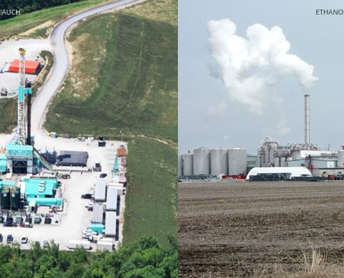 https://www.fractracker.org/a5ej20sjfwe/wp-content/uploads/2017/04/Ethanol-fracking-Feature.jpg
400
900
Ted Auch, PhD
https://www.fractracker.org/a5ej20sjfwe/wp-content/uploads/2025/09/2025-Wordmark-Logo.png
Ted Auch, PhD2017-05-22 16:05:562021-04-15 15:03:05North American Ethanol’s Land, Water, Nutrient, and Waste Impact
https://www.fractracker.org/a5ej20sjfwe/wp-content/uploads/2017/04/Ethanol-fracking-Feature.jpg
400
900
Ted Auch, PhD
https://www.fractracker.org/a5ej20sjfwe/wp-content/uploads/2025/09/2025-Wordmark-Logo.png
Ted Auch, PhD2017-05-22 16:05:562021-04-15 15:03:05North American Ethanol’s Land, Water, Nutrient, and Waste Impact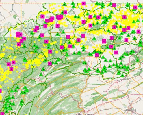 https://www.fractracker.org/a5ej20sjfwe/wp-content/uploads/2017/05/Susquehanna-2-Feature-WP.jpg
400
900
Matt Kelso, BA
https://www.fractracker.org/a5ej20sjfwe/wp-content/uploads/2025/09/2025-Wordmark-Logo.png
Matt Kelso, BA2017-05-02 13:17:582021-04-15 15:03:08Violations and Monitoring in Pennsylvania’s Susquehanna River Basin
https://www.fractracker.org/a5ej20sjfwe/wp-content/uploads/2017/05/Susquehanna-2-Feature-WP.jpg
400
900
Matt Kelso, BA
https://www.fractracker.org/a5ej20sjfwe/wp-content/uploads/2025/09/2025-Wordmark-Logo.png
Matt Kelso, BA2017-05-02 13:17:582021-04-15 15:03:08Violations and Monitoring in Pennsylvania’s Susquehanna River Basin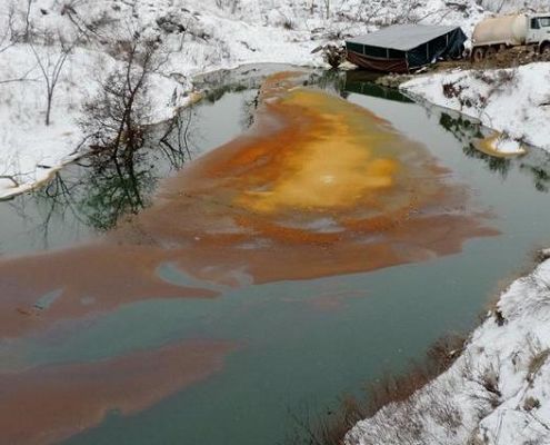 https://www.fractracker.org/a5ej20sjfwe/wp-content/uploads/2017/04/OilSpill_12.16_crop.jpg
400
900
Kyle Ferrar, MPH
https://www.fractracker.org/a5ej20sjfwe/wp-content/uploads/2025/09/2025-Wordmark-Logo.png
Kyle Ferrar, MPH2017-04-11 16:15:232021-04-15 15:03:11Oil Spills in North Dakota: What does DAPL mean for North Dakota’s future?
https://www.fractracker.org/a5ej20sjfwe/wp-content/uploads/2017/04/OilSpill_12.16_crop.jpg
400
900
Kyle Ferrar, MPH
https://www.fractracker.org/a5ej20sjfwe/wp-content/uploads/2025/09/2025-Wordmark-Logo.png
Kyle Ferrar, MPH2017-04-11 16:15:232021-04-15 15:03:11Oil Spills in North Dakota: What does DAPL mean for North Dakota’s future?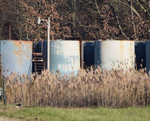 https://www.fractracker.org/a5ej20sjfwe/wp-content/uploads/2016/07/ClassIIOhio-Feature.jpg
400
900
Ted Auch, PhD
https://www.fractracker.org/a5ej20sjfwe/wp-content/uploads/2025/09/2025-Wordmark-Logo.png
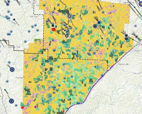
Ted Auch, PhD2017-03-02 16:46:592021-04-15 15:03:40Ohio Shale Activity, Waste Disposal, and Public Water Supplies
https://www.fractracker.org/a5ej20sjfwe/wp-content/uploads/2016/07/ClassIIOhio-Feature.jpg
400
900
Ted Auch, PhD
https://www.fractracker.org/a5ej20sjfwe/wp-content/uploads/2025/09/2025-Wordmark-Logo.png
Ted Auch, PhD2017-03-02 16:46:592021-04-15 15:03:40Ohio Shale Activity, Waste Disposal, and Public Water Supplies https://www.fractracker.org/a5ej20sjfwe/wp-content/uploads/2017/02/ME2_technical_def_header.jpg
400
900
FracTracker Alliance
https://www.fractracker.org/a5ej20sjfwe/wp-content/uploads/2025/09/2025-Wordmark-Logo.png
FracTracker Alliance2017-02-09 11:47:092021-04-15 15:03:45Remaining Questions on Mariner East Technical Deficiencies
https://www.fractracker.org/a5ej20sjfwe/wp-content/uploads/2017/02/ME2_technical_def_header.jpg
400
900
FracTracker Alliance
https://www.fractracker.org/a5ej20sjfwe/wp-content/uploads/2025/09/2025-Wordmark-Logo.png
FracTracker Alliance2017-02-09 11:47:092021-04-15 15:03:45Remaining Questions on Mariner East Technical Deficiencies![]()
216 Franklin St, Suite 400, Johnstown, PA 15901
Phone: +1 (717) 303-0403 | info@fractracker.org
FracTracker Alliance is a 501(c)3 non-profit: Tax identification number: 80-0844297
