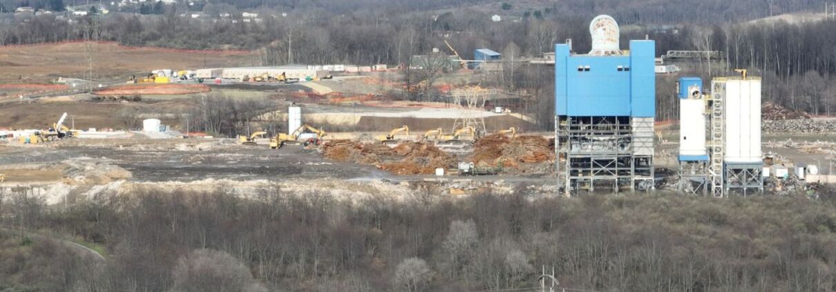
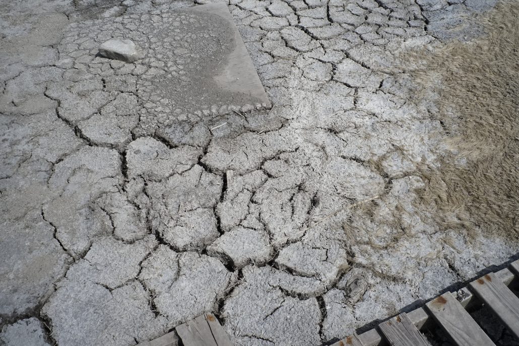
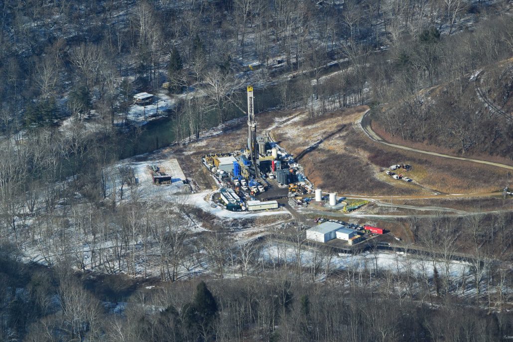
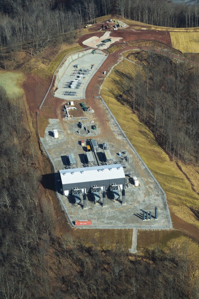
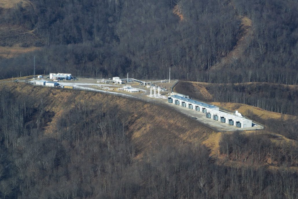
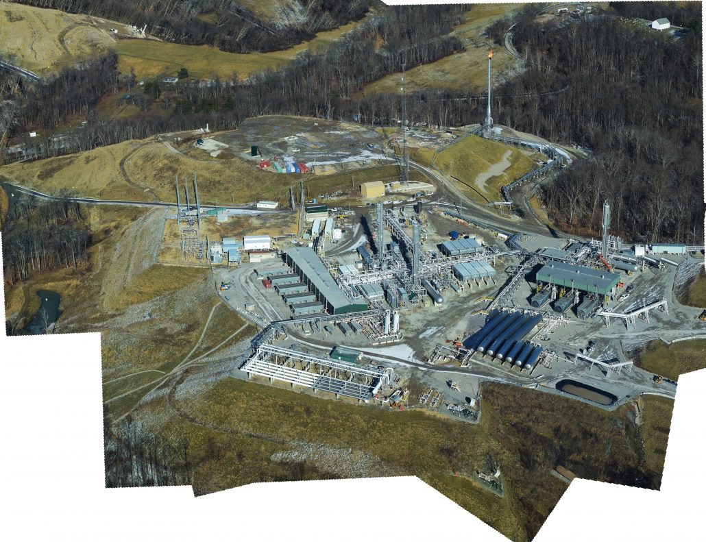
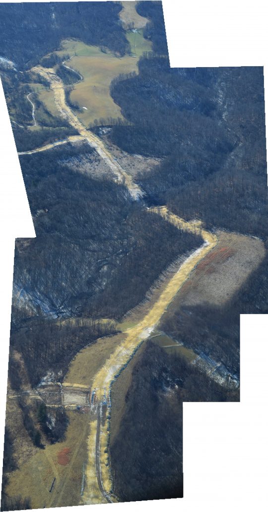
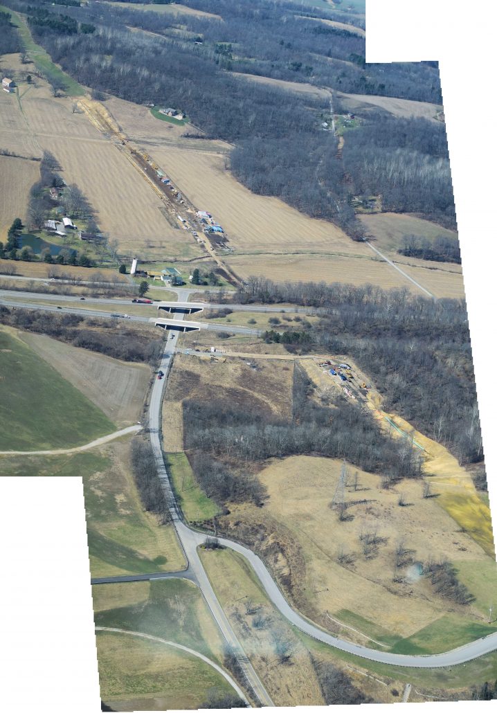
FracTracker documented early construction and demolition activity at the former Homer City coal plant, now being redeveloped into a fracked gas-powered AI and high-performance computing campus in Indiana County, Pennsylvania.
https://www.fractracker.org/a5ej20sjfwe/wp-content/uploads/2026/05/Untitled-design.jpg8441500FracTracker Alliancehttps://www.fractracker.org/a5ej20sjfwe/wp-content/uploads/2025/09/2025-Wordmark-Logo.pngFracTracker Alliance2026-04-30 17:32:352026-05-28 13:40:18From Coal Plant to AI Campus: FracTracker Documents Construction at Homer City
It’s been a little over a year since I visited the Texas Gulf Coast to document the oil, gas, and petrochemical landscape with our partners at LightHawk and Scott Humphries, an amazing pilot and Houston native.
Much has happened since then – in regard to and because of – the Gulf Coast’s petrochemical industry.
The fossil fuel landscape along the Gulf Coast is broad, and its impact is heavy.
The area has seen a massive build out over the last five years. New plastics and steel manufacturing facilities and pipelines from the Permian Basin that transport crude to ever-expanding tank farms and marine terminals – all with the blessings of local economic development groups and local government, despite known present and potential hazards.
As these developments continue, communities and workers pay the price. An incident in early December, 2020 left workers injured after a condensate fire at a Citgo tank farm in Corpus Christi. Before that, a pipeline explosion on August 20th in the Corpus Christi Ship Channel resulted in four deaths, with only two of those bodies recovered.
Channels of Life, below, is a short video looking at what is already on the ground, and what is on the horizon. Whether you are pleasure-boating in the channels or driving down the highway, you only see the edge of industrial sprawl that already exists. The depth of the incursion is not visible from the ground. Further down in an interactive Story Map, we give you a rare look from above, while pinpointing various incidents and facilities of concern. Partnering with LightHawk, we flew from Port Aransas, up the La Quinta Channel to the Nueces Delta, and ending at Refinery Row, giving you a bird’s-eye view of the sprawling fossil fuel landscape.
How much more industrial saturation can the Coastal Bend’s public health and ecosystem withstand before it is all sacrificed?
Is it destined to become a sacrifice zone for increasing corporate wealth and prestige?
In many parts of Texas – as well as in Louisiana and New Mexico – oil, gas, and petrochemical facilities abut schools, backyards, and playgrounds. The Gulf Coast contains 95% of the country’s ethylene capacity and roughly half of the country’s petroleum refining and natural gas processing capacity. This development has propelled a new wave of petroleum and petrochemical infrastructure in recent years. There are 129 planned or recently completed petrochemical facilities in TX and LA alone.
This buildout has enormous consequences for the country’s greenhouse gas emissions, including intensifying climate change; increasing production of (often radioactive) waste and the need for its disposal; and discharging dangerous pollution into frontline communities where health has already been compromised by industry activities.
As the sacrifice builds and the losses mount, economic development corporations advertise the area as prime real estate for more facilities and infrastructure – even as markets steadily move away from fossil fuels. Exports are a tenuous lifeline for an industry drowning in an oversupply of oil and gas, but advocates like the Port of Corpus Christi Authority insist on proposing, financing, and constructing new crude oil and liquefied natural gas (LNG) export terminals along the Gulf Coast, including the BlueWater and GulfLink terminals.
Even with access to global markets, the outlook for this Gulf Coast petrochemical expansion doesn’t look great. Countries that planned to import the US’ fossil fuels are withdrawing interest, citing climate concerns. Major projects are being abandoned, like the petrochemical facility Project Falcon that SABIC had planned to build near Aransas Pass. Frontline communities that have suffered devastating health impacts from the industry for too long are calling out environmental racism and causing major delays for new facilities.
These Texan sites are further captured in the Story Map below, as are the footprints of countless other existing and proposed petrochemical infrastructure sites, from the frac sand mines south of San Antonio down into Corpus Christi Bay, the mushrooming industry along the La Quinta Channel, up the Gulf Coast to Freeport, and finally along the always hectic Houston Ship Channel that empties out into Galveston Bay.
Left to Right: Corpus Christi native and Coastal Alliance to Protect Our Environment (CAPE) member Dewey Magee, FracTracker Alliance’s Ted Auch, and LightHawk pilot Scott Humphries stand outside Scott’s Beechcraft Bonanza A-36 at McCampbell-Porter Airport in Aransas Pass, TX, November 11th, 2019. Photo by Errol Summerlin
The View of Corpus Christi’s Petrochemical Corridor along La Quinta Channel and Tule Lake Shipping Channel from 200’ above McCampbell-Porter Airport in Aransas Pass, TX, November 11th, 2019. Photo by Ted Auch, FracTracker Alliance
I reached out to pilot and native Houstonian Scott Humphries for his thoughts on what he expected and what he gleaned from our flight. He wrote the following:
Question #1: What about our proposed flight interested you as a Texan and/or Houstonian – or just more generally – what interested you about this mission?
I’ve always tried to be environmentally conscious, and always try to have, “think globally, act locally” rummaging around in my head, but this mission (and affiliating with LightHawk generally) presented an opportunity for me to try to (hopefully) have a little more impact than just personally recycling, outlawing Styrofoam cups at our office, etc. Separately, as a longtime Houstonian, I’ve always been proud to live and work in what many refer to as the “Energy Capital of the World.” This mission seemed a useful way to do some small part to help make sure that title continues to be held responsibly.
Question #2: After conducting the flights, or as they were happening, did you learn anything, or have any thoughts that surprised you or realizations about anything particular?
I have flown along the Gulf Coast (including to/from Houston/Corpus Christi) many, many times, and if you’d asked me before this mission, I would have said, ‘Sure, there’s a decent amount of industry along that part of the coast.’ What surprised me while we were flying was two things: (1) there’s not just a decent amount of industry along that part of the coast; rather, along that route, even flying low, you’re rarely – if ever – out of sight of a significant facility of some kind, and (2) the size of the facilities – in other circumstances I’d have been flying much higher and wouldn’t get a good sense of the size of the pads. Flying as we were at just over 1000′, it was striking how massive the various plants were, both in Corpus Christi Bay and along the coast.
Another perspective on this flight and the area we flew over comes from Kevin Sims, Aransas Bay Birding Charters Operator whose Whooping Crane and Pink Spoonbill photos we feature in the story map below. Kevin has been plying the waters in and around Aransas Wildlife Refuge since 1972, and when I contacted him about using some of his photos, he told me the following:
“We need the desalination plants, but the planned discharge points are going to cripple our ecology and the business that rely on it for tourism. They could’ve discharged offshore, but instead they are discharging into the bay, and if it gets too salty the crab populations will plummet, and everything around here depends on crabs and shrimp. If we have a constant influx of brine it could really cripple us. I went to a fantastic meeting from Texas A&M, and their science told them that if red fish larvae migrated into the [Aransas Pass] shipping channel and hit a wall of salty water, they wouldn’t go further, and their population would crash. But despite these facts, they’ve chosen to discharge into the La Quinta Channel, and that is bad news! They were having fairly regular meetings on all of these proposals prior to COVID, but once COVID hit, they went all remote, and less people knew when the meetings were, and the meeting details weren’t widely disseminated … So, the next thing we knew, everything was passed, and they’re gonna [sic] go ahead and do [all of] it.
My perspective comes from a lifetime of fishing and observing the Whooping Crane, and watching them progress from 157 eighteen years ago, to 507 at the present time. Well, I feel this will threaten an endangered species that they’ve been trying to bring back from the brink of extinction since the 1940s. I can remember my dad showing me the cranes in the mid-70s, and there were only 52-55. All of the projects you are mapping have the potential to decimate all the progress made, not to mention money spent on Whooping Crane recovery. From my perspective, it’s a catch-22, ‘cause [sic] the big cities take the water out of the river, and they don’t have the inflows into the bays that they did in the past. We also don’t have the rains that we used to have. The desalination plants would relieve some of that pressure if they would just put that brine offshore. The other species of concern to my industry is the Pink Spoonbills, but the Whooping Crane is the main draw.”
Channels of Life: The Gulf Coast Buildout in TX
A Story Map
This Story Map illustrates the impacts of oil and gas infrastructure from San Antonio down to Corpus Christi, and then up the Gulf Coast to Houston.
The map displays aerial photographs of infrastructure, from frac sand mines and refineries, to chemical plants and offshore drill rig construction sites. This map includes CO2 emissions from oil and gas infrastructure from 2010 – 2018 (weighted by total CO2 during this period in orange), and/or oil refineries and their myriad products (weighted by capacity in black [barrels/day oil equivalents]).
The Story Map also presents detailed information and locations for proposed petrochemical infrastructure in the Corpus Christi Bay region, courtesy of Errol Summerlin and our partners at Coastal Alliance to Protect Our Environment (CAPE). These proposals include dredging projects needed to accommodate more traffic from larger tanker ships, as well as desalination facilities that would collectively intake 758 million gallons of Corpus Christi Bay water each day, and discharge 507 million gallons of brine per day, with an average of 95 and 64 million gallons of desalinated water produced daily, respectively.
The perforated yellow line is the flight path we took with our LightHawk partners. When the viewer scrolls into any given region, they will see SkyTruth incident alerts within five miles of our flight path. The two examples cited at the beginning of this article are just a couple of the nearly 760 such incidents in just the Corpus Christi Shipping Channel since 2011, according to data provided by SkyTruth.
The most recent data in this map is Whooping Crane locations and number counts in TX as of November 2020, courtesy of The Cornell Lab of Ornithology’s eBird data portal. This data speaks to the concerns of Mr. Sims and many of his colleagues who rely on the Whooping Crane’s attraction to birders internationally, and it also highlights that the projects photographed and in the works across Corpus Christi Bay will not just negatively affect the human communities, but will have far reaching impacts on the ecosystems of the western Gulf, and the industries that have relied on these ecosystems for all manner of ecosystems services.
Decades of oil and gas development have created a dependency on extractive industries, which has in turn hindered community health and stability.
The Port of Corpus Christi’s controversial dock expansion and Harbor Bridge replacement project at the southern end of Refinery Row has taken over community land and eclipsed their fight to protect their neighborhoods and their public health. Even after an environmental review, the preferred route cuts through these neighborhoods that are surrounded by industry, interstates, and waste treatment facilities – isolated from other residences, and subjected to heavy pollution, noise, and constant hazard.
But with interest and investments declining in the fossil fuel industry and overproduction keeping prices low, the future of the Gulf Coast, its people, environment, and industrial landscape is uncertain – but resistance to extractive industry is strong.
Several activists and environmental coalitions are fighting this project and the industrial onslaught for the health of their communities. For more information on how to support their vision, visit our friends at Coastal Alliance to Protect our Environment (CAPE) and Texas Environmental Justice Advocacy Services (TEJAS).
Thank You
This video, Story Map and article were produced with much gratitude and appreciation for our partners at LightHawk, as well as the support and resources of Scott Humphries, Kevin Sims, and Errol Summerlin.
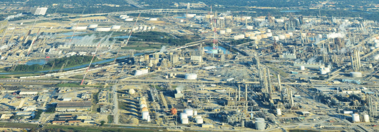
https://www.fractracker.org/a5ej20sjfwe/wp-content/uploads/2020/12/TAuch_Infrastructure-Refinery-BritishPetroleum-TexasCity_TX_LightHawk_Nov2019-Feature-scaled.jpg6671500Ted Auch, PhDhttps://www.fractracker.org/a5ej20sjfwe/wp-content/uploads/2025/09/2025-Wordmark-Logo.pngTed Auch, PhD2020-12-23 16:23:392021-04-15 14:16:01Channels of Life: The Gulf Coast Buildout in Texas
by Ted Auch, FracTracker Great Lakes Program Coordinator, and Rebecca Johnson, Communications & Administrative Specialist
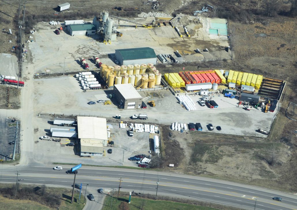
FracTracker is pleased to release our improved multimedia platform of fracking imagery for your convenient use. You can easily view, download, and share photos and videos of oil, gas, and petrochemical impacts. We’ve made it easy for you to find what you need within over 1,600 photos, GIFs, and videos of the various aspects of fossil fuel industries and activities. All media are free to download and use for all visitors, and the collection will only expand as our work continues!
“The aeroplane has unveiled for us the true face of the earth.” by French writer and aviator Antoine de Saint-Exupéry author of Le Petit Prince (The Little Prince)
Ted Auch, FracTracker Great Lakes Program Coordinator:
It was nearly five years ago on a beautiful Wednesday morning that I met Paul Feezel, a concerned citizen of Carroll County, Ohio, and Cleveland Museum of Natural History’s David Beach at the Carroll County-Tolson Airport (40.5616667, -81.0780833). The occasion was a flight with pilot Mike Stich to see what the Fracking Boom had done to Carroll and neighboring counties.
The aspect of the industry that I came away from that flight most worried about was the hundreds of miles of pipelines we saw connecting well pad to well pad and meandering on downstream to processing facilities. These pipelines took such circuitous routes between pads that everyone in the plane was scratching their heads, wondering how such routes made any financial sense for the operators to get their raw product to market.
Ever since that flight, I have spent a significant chunk of my time at FracTracker mapping the extent of these so-called gas “gathering pipelines” across Ohio, West Virginia, and Pennsylvania. I remain as flummoxed as I was on that day how such a hastily laid and poorly regulated network of pipelines makes sense. More recently, I have been wondering what the cumulative impact of these non-FERC-regulated pipelines has been on forests, wetlands, and the remaining agriculture in the region.
We have flown over this area several more times since that initial flight, with pilots volunteering their time to navigate planes provided by our excellent partners at LightHawk. As I wrote a little over two years ago:
“… you can’t really understand or appreciate the enormity, heterogeneity, and complexity of the unconventional oil and gas industry’s impact unless you look at the landscape from the cockpit of a Cessna 172. This vantage point allows you to see the grandeur and nuance of all things beautiful and humbling. Conversely, and unfortunately more to the point of what I’ve seen in the last year, a Cessna allows one to really absorb the extent, degree, and intensity of all things destructive. I’ve had the opportunity to hop on board the planes of some amazing pilots, like Dave Warner, a forester formerly of Shanks, West Virginia … Tim Jacobson, Esq., out of La Crosse, Wisconsin, northern Illinois retired commodity and tree farmer Doug Harford, and Target corporate jet pilot Fred Muskol, out of the Twin Cities area of Minnesota.”
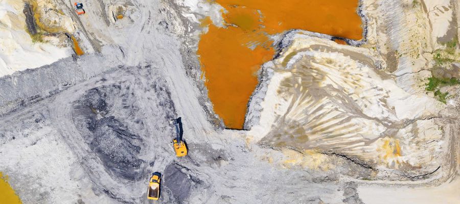
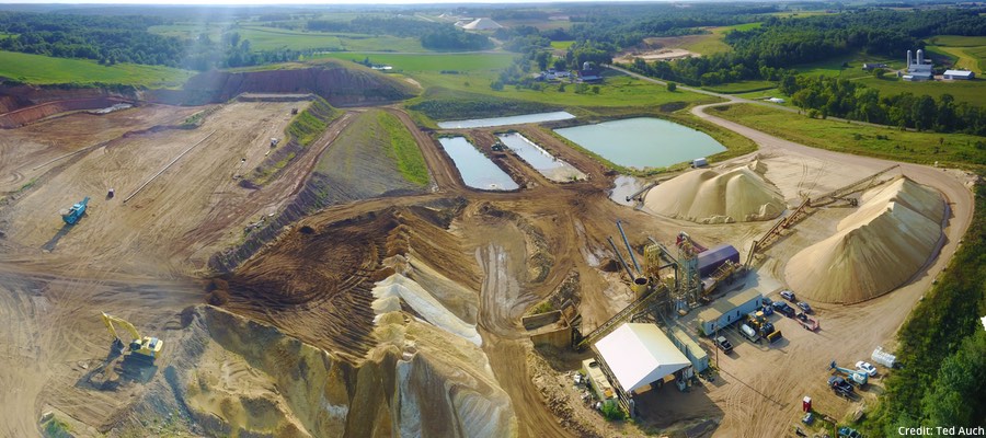
Frac sand mine impoundment pond in Wedron, IL, 2018. Photo by Ted Auch, with aerial assistance from Lighthawk.
I wrote the “Bird’s-Eye-View” piece in August 2018, and since then we’ve made additional flights with our LightHawk partners, including a harrowing flight over Pine Creek State Park in Pennsylvania last May, part of our “Wilderness Lost” digital atlas series that now includes a similar project for the adjoining Loyalsock Creek.
The May 2019 flight was exhilarating to say the least – and thanks to the skills of our pilot Steve Kent, we executed the flight and extracted some powerful imagery that was three months later appended during better flying conditions with pilot Bob Keller. This flight was notable because the cloud ceiling was around 2,400 feet, and some peaks we were flying over and around were in excess of 1,200 feet, which gave us very little room to maneuver, at times forcing us to fly down into valleys to avoid the clouds. This flight also was a great opportunity for me and Steve to practice our communication, given that we were flying so low and slow, which meant that Steve would basically give me a ten-second slot to open my window, lean out, and shoot, while he was banking around the site of interest. Unlike other flights – including the subsequent flight in the Pine Creek – we did not have any opportunities to fly around infrastructure more than once, given how volatile the cloud ceiling was, and that if there was an opening that would allow us to move laterally, we had to take it.
Between our Pine Creek flights and that initial Carroll County aerial tour, we’ve compiled literally thousands of high-quality and illustrative images of the Hydraulic Fracturing Industrial Complex. When we say “hydraulic fracturing” – or “fracking” – we are not simply referring to drill rigs and frack pads, like the industry would limit us to in our analysis, but rather all manner of activities and infrastructure, to include drill rigs and pads – but also pipelines, waste disposal sites, processing plants, and frac sand mining activities, from the aforementioned forests of northeastern Pennsylvania, to Texas’ Gulf Coast. To this point, several authors have used our imagery, such as Paul Bogard and Tom Pearson, the Proceedings of the National Academy of Sciences (PNAS), Yale Environment 360, Oil Change International, the Anthropology Magazine SAPIENS, etc.
Since COVID-19 brought everything to a halt, my colleague Rebecca Johnson and I have been working to organize these images, migrating our older and more cumbersome inventory to the image and video hosting website Flickr, where we could more appropriately catalog, group, and map these images.
Please make use of this resource and keep fighting for a more just energy future.
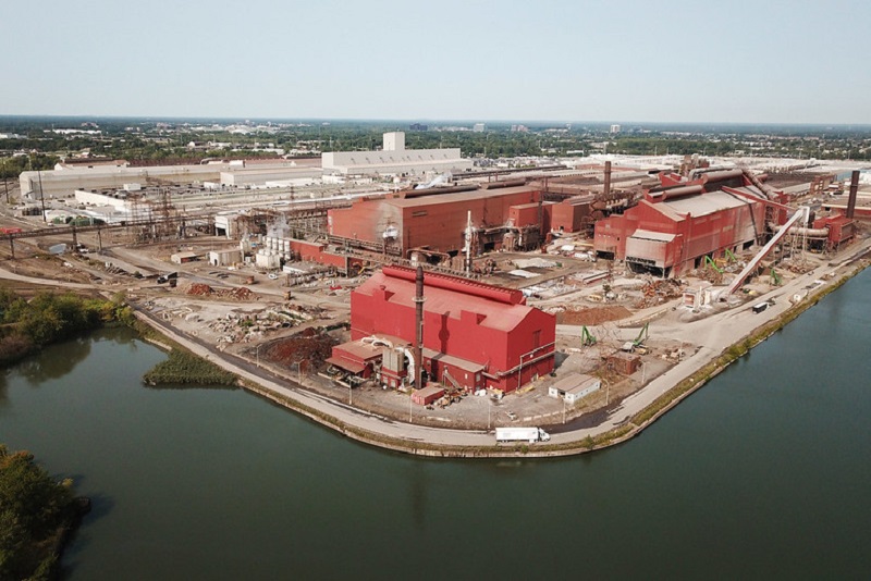
Steel plants in Detroit, MI. Photo by Ted Auch, FracTracker Alliance, with aerial assistance from Lighthawk.
I began working with FracTracker in May 2019, coming in with a new and relatively limited perspective on the energy landscape, compared to Ted’s, my partner in this undertaking, who has spent years – from the ground and from above – capturing this expansion, its degradation, and the challenges it presents. After seeing the collection of Ted’s and others’ pictures on our website, I knew we needed to amplify our efforts in graphic documentation, in order for more people to see and feel what we are collectively up against.
This task was not taken lightly. FracTracker’s imagery backlog was daunting, to say the least. I scrolled through countless pictures and videos of different aspects of fossil fuel infrastructure and activity until my eyes glazed over. I had no idea the extent of the industry landscape and its effects – and so I had no idea where to even begin. The collection was immense, but the need to get more eyes on these revealing depictions was even bigger.
How was best to expose and illuminate the extensive buildout of and degradation from these resource-intensive, extractive industries?
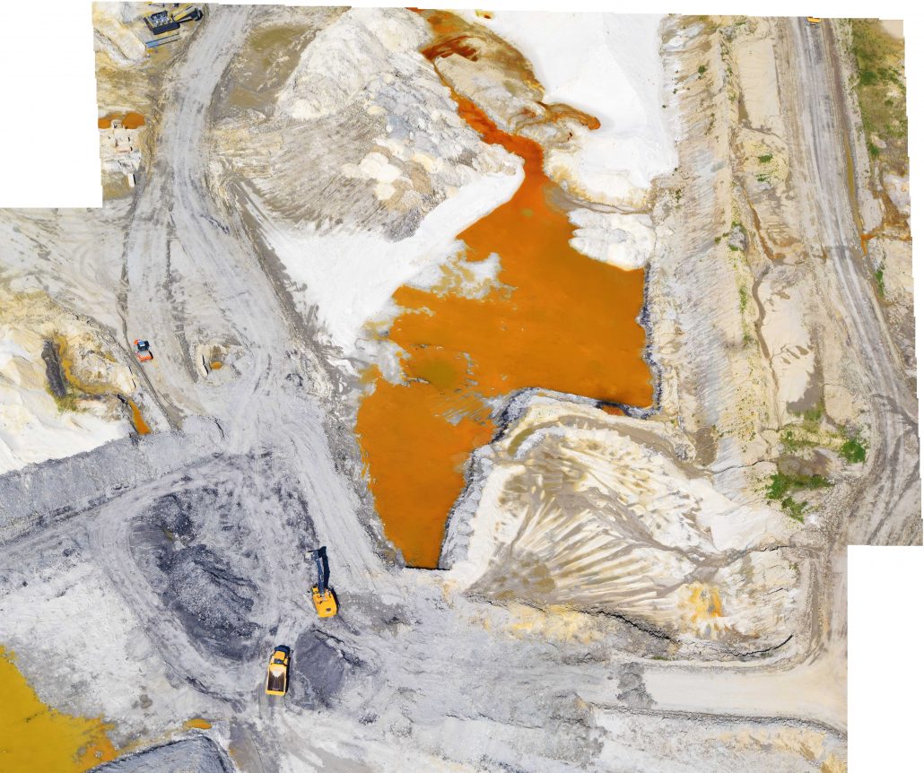
Cataloguing began with the frac sand industry, and I slowly pieced together the breadth and depth of resource extraction. The aerial snapshots and panoramic captures of enormous mines, immense sand piles, and vast, sandy, slurry ponds connected by looming conveyors and miles of train tracks created a twisting path through my mind, traversing the various stages of extraction to production, through landscapes wrought with reckless human consumption. But frac sand is only one starting point in the onslaught, is only an upstream activity that sets the stage for further ruin downstream, with oil and gas extraction, petrochemical and plastic production, and various types of pollution and erroneous waste disposal from all these activities – not to mention the waste and pollution following human consumption, when we think we are “done” with a material.
As I sifted through images, the dots started connecting, and what started as a simple list of subjects quickly became an outline of what our country’s communities and environment were up against. Navigating through the picture hoard, Ted and I regularly discussed the people he had met while capturing these shots.
He spoke of friends he has made along the way – people in communities that had endured this buildout, seeing their lands chipped away, their natural corridors disconnected, and their waterways depleted or entirely consumed to make room for more industrial sites. It had compelled some of them to leave their homes, and some were even forced to abandon their sacred lands, left only with the lasting, heartbreaking memory of seeing it sullied beyond recognition and repair.
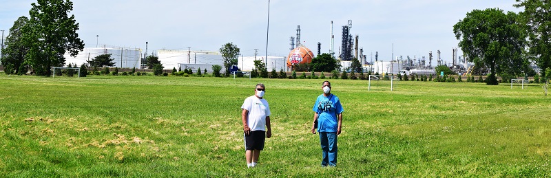
Detroit residents Doug Wood and Theresa Landrum stand in front of a Marathon Oil refinery in southwest Detroit, MI, 2020. Photo by Ted Auch, FracTracker Alliance.
This realization lead to our stepwise sorting of imagery by these industries and activities to include the impacts and hazards to communities, culture, and livelihoods, already endured, happening currently, and looming ominously in the future. It’s easy to see the negative alterations from a bird’s-eye view, with the tainted landscape laid out below, punctured by ugly facilities and marred by indiscriminate ruin. It is another, more emotional thing to connect these scenes to those living in them, to the livelihoods dissolved and the generational homes displaced. Farmers have seen their lands infringed upon, their soils tainted and their waters poisoned. Communities have witnessed their air quality deteriorate, their children and friends fall sick, and their neighborhoods empty, at the expense of these industries. An often-overlooked aspect of extraction is those who bear its initial ramifications in their own communities.
At this point, we’ve winnowed our vast trove of imagery down to over 1,600 images across 46 albums. After weeding through this extensive catalog to identify our most powerful snapshots, we thought it would be appropriate to present the first iteration of this over five-month project to our audience and collaborators, with the hopes of better informing/illustrating your work.
With our migration to Flickr, I hope more eyes find this imagery, explore our collections, and follow the connections from album to album, to better understand the effects of fossil fuel activities. Whether it is the withered landscapes, the depleted environments, or the fragmented lives that speak to the viewer most, it is important to remember what has been endured to procure these resources, and what it will take to move to a cleaner, more just energy landscape.
In the event some of you were not aware of certain aspects of the industry, please take this opportunity to tour these albums and familiarize yourself with the myriad infrastructure and impacts of fracking.
A primary source of inspiration for this aerial photography endeavor is the late Bill Hughes out of Wetzel County, West Virginia, who left us in March 2019. Bill was a force of nature in West Virginia’s documentation, with his camera and local know-how, the fracking industry’s negligence, and the fact that they seemed to run roughshod over his beloved state’s beautiful landscape. As our Executive Director Brook Lenker wrote following Bill’s death:
“Just taking pictures was not enough. Context was needed. Bill interpreted each picture – explaining the location, thing or activity, and significance of every image. Did it represent a threat to our water, air, or land? When did it happen? What happened before and after? Did it show a short- or long-term problem? Should state regulatory agencies see it to become better informed? Dissemination followed in many forms: tours of the gas fields; power point presentations to groups in five states; op-ed pieces written for news media; countless responses to questions and inquiries; even blogs and photo essays for various websites. Ceaseless Bill never stopped caring. Maybe Bill Hughes should be an official emblem for Earth Day – a humble, faithful man of modest proportions, spreading the stewardship imperative from a little electric car. Hitch a ride, follow his lead, and, like Bill, always tell it like it is.”
We hope that our work in the air and on the ground photographing industry impacts would make Bill proud. We will continuously update these Flickr albums, and offer as much background and locational data as possible to facilitate an unsurpassed level of depth and breadth for all users.
“The aeroplane has unveiled for us the true face of the earth.” by French writer and aviator Antoine de Saint-Exupéry author of Le Petit Prince (The Little Prince)
I always tell people that you can’t really understand or appreciate the enormity, heterogeneity, and complexity of the unconventional oil and gas industry’s impact unless you look at the landscape from the cockpit of a Cessna 172. This bird’s-eye-view allows you to see the grandeur and nuance of all things beautiful and humbling. Conversely, and unfortunately more to the point of what I’ve seen in the last year, a Cessna allows one to really absorb the extent, degree, and intensity of all things destructive.
I’ve had the opportunity to hop on board the planes of some amazing pilots like Dave Warner, a forester formerly of Shanks, West Virginia (Note: More on our harrowing West Virginia flight with Dave later!!), Tim Jacobson Esq. out of La Crosse, Wisconsin, northern Illinois retired commodity and tree farmer Doug Harford, and Target corporate jet pilot Fred Muskol out of the Twin Cities area of Minnesota.
Since joining FracTracker I’ve been fortunate to have completed nearly a dozen of these “morning flights” as I like to call them, and five of those have taken place since August 2017. I’m going to take the next few paragraphs to share what I’ve found in my own words and by way of some of the photos I think really capture how hydraulic fracturing, and all of its tentacles, has impacted the landscape.
The following is by no means an empirical illustration. I’m increasingly aware, however, that often times tables, charts, and graphs fail to capture much of the scale and scope of fossil fuel’s impact. Photos, if properly georeferenced and curated, are as robust a source of data as a spreadsheet or shapefile, both of which are the traditional coins of the realm here at FracTracker.
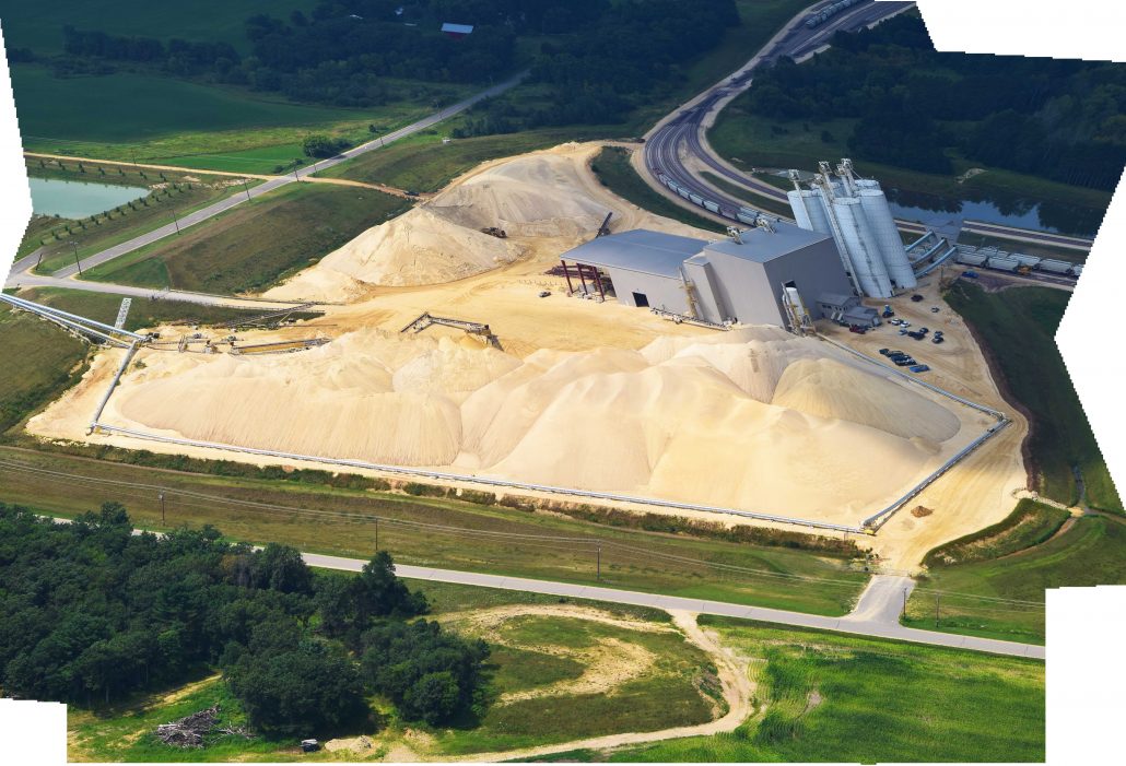
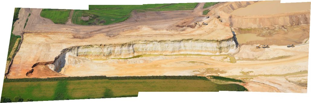
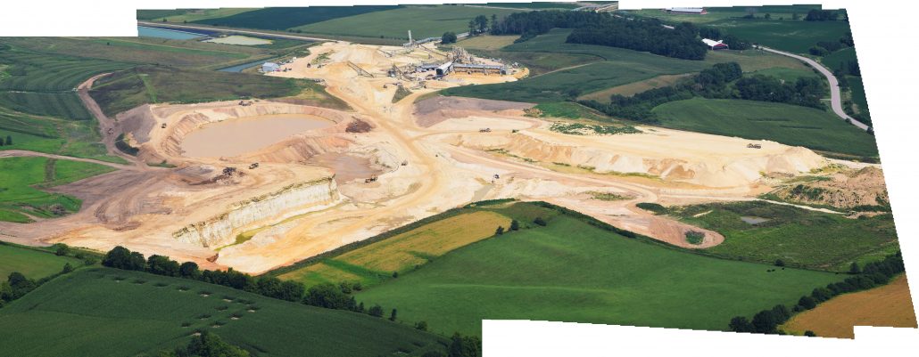
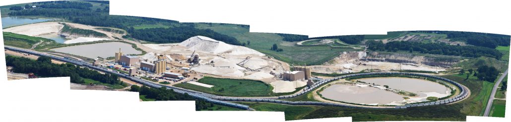
West Central Wisconsin Frac Sand Mines
August 2, 2017
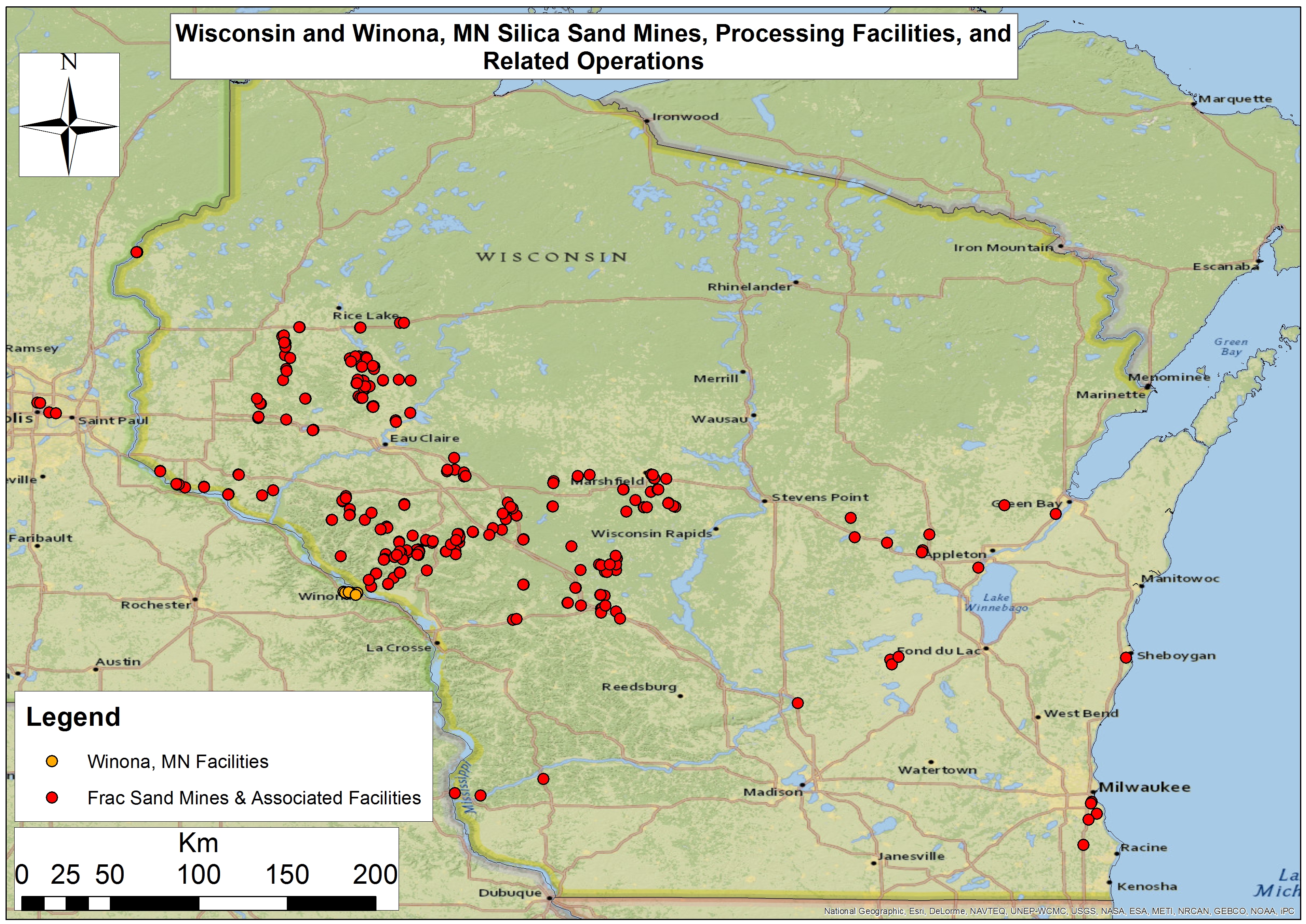
Figure 1. Wisconsin and Winona, Minnesota silica sand mines, processing facilities, and related operations
It was nearly a year ago today that I met Bloomer, Wisconsin dairy farmer Ken Schmitt at the Chippewa Valley Regional Airport (KEAU) and soon thereafter jumped into Tim Jacobson’s Cessna 172 to get a bird’s-eye-view of the region’s many frac sand mines and their impacts (Figure 1). These sites are spread out over a 12-county region known as West Central Wisconsin (WCW). Ken hadn’t been up to see these mines since October of 2016 and was eager to see how they had “progressed,” knowing what he did about their impact on his neck of the woods in northern Chippewa County.
Ken is one of the smartest guys I’ve ever met, and – befitting a dairy farmer – he is also one of the most conservative and analytical folks I’ve ever met. However, that morning it was clear that his patience with county administrators and the frac sand mining industry had long since run out. He was tired of broken promises, their clear and ubiquitous bullying tactics, and a general sense that his livelihood and the farm he was hoping to leave his kids were at risk due to sand mining’s complete capture of WCW’s residents and administrators.
Meanwhile Mr. Jacobson Esq. was intimately familiar with some of the legal tools residents were using to fight the spread of sand mining in the WCW. This is something he referred to as “anticipatory nuisance” lawsuits, which he and his colleagues were pursuing on behalf of several landowners against OmniTrax’s (f/k/a Terracor) “sand mine, wet and dry processing, a conveyor system to a rail load out with manifest yard” proposal in Jackson County, Wisconsin. I, too, have worked with Tim to inform some of his legal work with respect to the nuisance stories and incidents I’ve documented in my travels, as well as research into the effects of sand mining across Michigan, Illinois, Minnesota, and Wisconsin.
Explore details from our sand mining tour by clicking on the images below:
Our flight lasted nearly 2.5 hours and stretched out over 4,522 square miles. It included nearly 20 sand mines – and related infrastructure – in the counties of Jackson, Wood, Clark, Eau Claire, Monroe, Trempealeau, and Buffalo. What we saw was a sizeable expansion of the mining complex in the region since the last time I flew the area – nearly four years earlier on October 8, 2013. The number and size of mines that had popped up since that trip were far greater than any of us had expected.
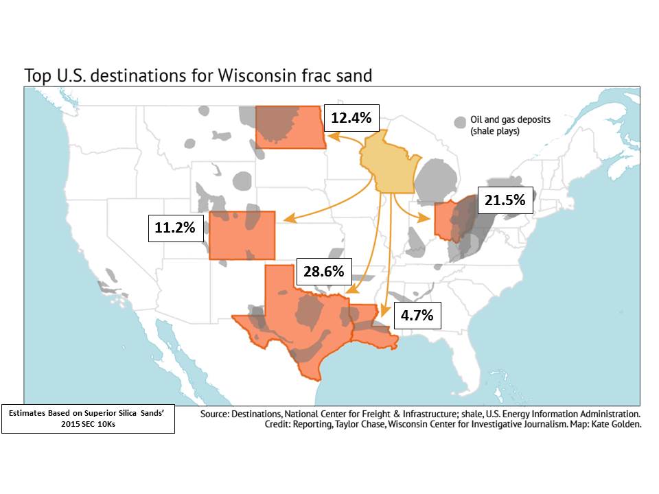
This expansion paralleled the relative – and total –increase in demand for “proppant” from the High Volume Hydraulic Fracturing (HVHF) all across the country (Figure 2).
Figure 2. A map of the likely destination for Wisconsin’s frac sand mines silica sand based on an analysis of Superior Silica Sand’s 2015 SEC 10Ks.
West Virginia Panhandle & Southeastern Ohio
January 26, 2018
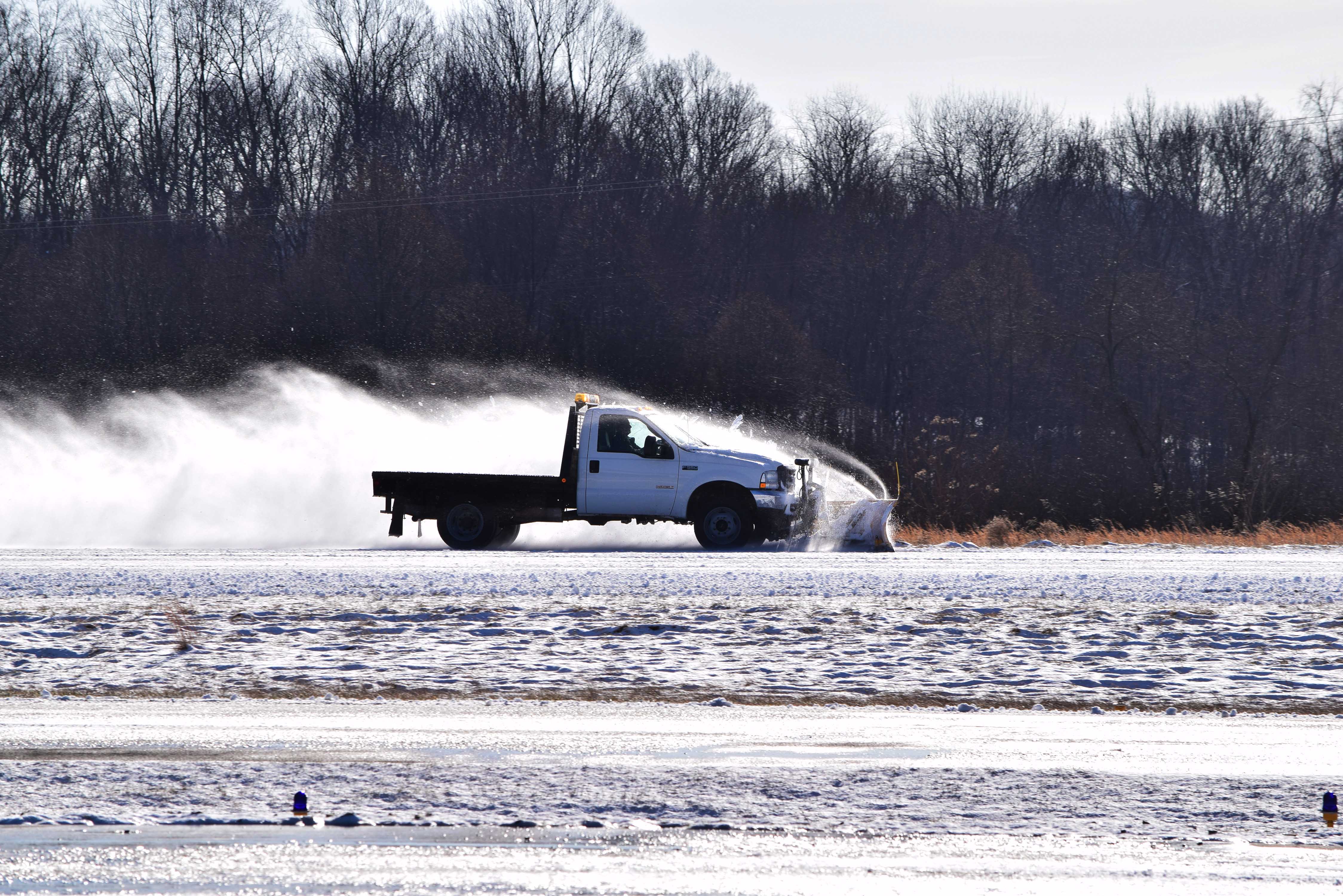
On the morning of January 26th, I woke up on the west side of Cleveland thinking there was very little chance we were going to get up in the air for our flight with SouthWings’ pilot Dave Warner due to inclement weather. There was a part of me that was optimistic, however, so I decided to make the three hour drive down to the Marshall County Airport (KMPG) in Moundsville, West Virginia from Cleveland in the hopes that the “cold rain and snow” we’d been receiving was purely lake effect stuff and the West Virginia panhandle had not been in the path of the same cold front.
Marshall County, West Virginia Airport (KMPG) staff clearing the runway for our flight with SouthWings pilot Dave Warner, 1/26/2018
Unfortunately, when I arrived at the Moundsville airport I was wrong, and the runway was pretty slick around 8:00 a.m. However, the airport’s staff worked diligently to de-ice and plow the runway and by the time Dave Warner arrived from southern West Virginia conditions were ideal. The goal of this flight was two-fold:
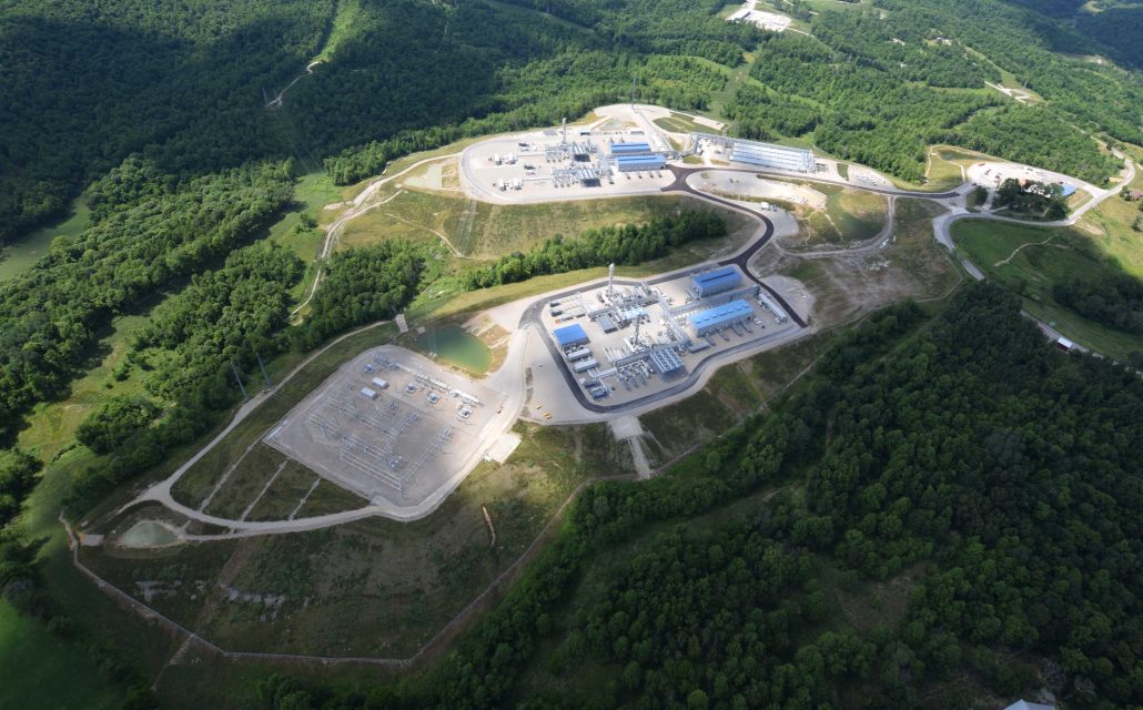
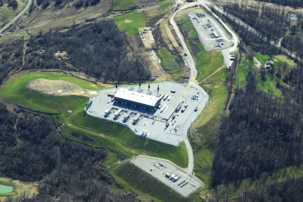
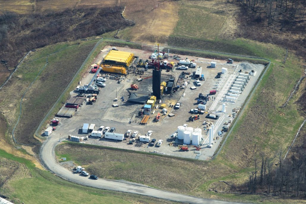
Photograph some of the large-scale high-volume hydraulic fracturing (HVHF) infrastructure in the West Virginia counties of Doddridge, Wetzel, and Marshall owned and operated by MarkWest, and
Allegheny Front’s Julie Grant was doing a story on natural gas gathering pipeline’s impact on waterways, and more specifically the Hellbender Salamander (Cryptobranchus alleganiensis). She was looking to see the impacted landscape from the air.
Both of these goals were achieved efficiently and safely, with the resulting Allegheny Front piece receiving significant interest across multiple public radio and television platforms including PRI’s Living On Earth.
Explore details from our WV / OH tour by clicking on the images below:
On my return drive home that afternoon the one new thing that really resonated with me was the fact that hydraulic fracturing or fracking has come to be defined by 4-5 acre well pads across Appalachian, Texas, Oklahoma, and North Dakota. This is a myth, however, expertly perpetuated by the oil and gas industry and their talking shops. Fracking’s extreme volatility and quick declines in rates of return necessitate that this latest fossil fuel iteration install large pieces of infrastructure like compressor stations and cracking facilities. This all is to ensure timely movement of product from supply to demand and to optimize the “value added” products the global markets demand and plastics industry uses as their primary feedstocks. This large infrastructure was never mentioned at the outset of the shale revolution, and I would imagine if it had been there would be far more resistance.
The one old thing the trip reinforced was the omnipresence and sinuosity of natural gas gathering lines across extremely steep and forested Appalachian geographies. How these pipelines will hold up and what their hasty construction is doing to terrestrial and aquatic wildlife, not to mention humanity, is anyone’s guess; the data is just so darn bad.
Southeastern Ohio
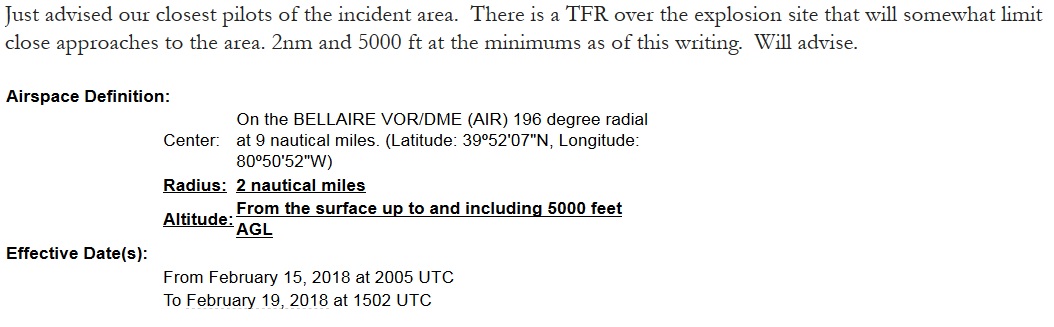
March 5, 2018 – aka, The XTO Powhatan Point Well Pad Explosion Flight
Around 9 a.m. on Thursday, February 15, 2018, an explosion occurred at XTO’s Schnegg frack pad “as the company worked to frack a fourth well” in Powhatan Point, Belmont County, Ohio. Shortly thereafter, a two-mile Temporary Flight Restriction (TFR) was enacted by the Federal Aviation Administration (FAA) around the incident’s location. The TFR was supposed to lapse during the afternoon of March 5, however, due to complications at the site the TFR was extended to the evening of March 8.
We were antsy to see what we could see, so we caught an emergency flight with Dave Warner, only this time under the LightHawk umbrella. We left on the morning of March 5th out of the all too familiar[1]Carroll County-Tolson Airport (KTSO). Although we couldn’t get close to the site, there was a holler valley to the northwest of the pad that allowed us to capture a photo of the ongoing releases. Additionally, within several weeks we obtained by FOIA the raw Ohio State Trooper monitoring footage from their helicopter and posted this footage to our YouTube channel, where it has received 4,787 views since March 19, 2018. This type of web traffic is atypical for anything that doesn’t include kittens, the Kardashians, or the Kardashians’ kittens.
Explore details from our Southeastern Ohio tour by clicking on the images below:
Much like our flight in January the most salient points I got out of Dave’s plane thinking about were:
Astonishment regarding the number of gas gathering lines and the fact that they seem to have been installed with very little-to-no reclamation forethought. They are also installed during a time of year when – even if hydroseed is applied – it won’t grow, leaving plenty of chances for predictable spring rains to cause major problems for streams and creeks, and
It is a big plant, a very big plant and far bigger than other plants around here… What’s really amazing that we got it up and running in six months. No one believed that we could do that. – Momentum Midstream spokesman Eric Mize discussing their natural gas liquids-separating complex in Scio, Ohio.
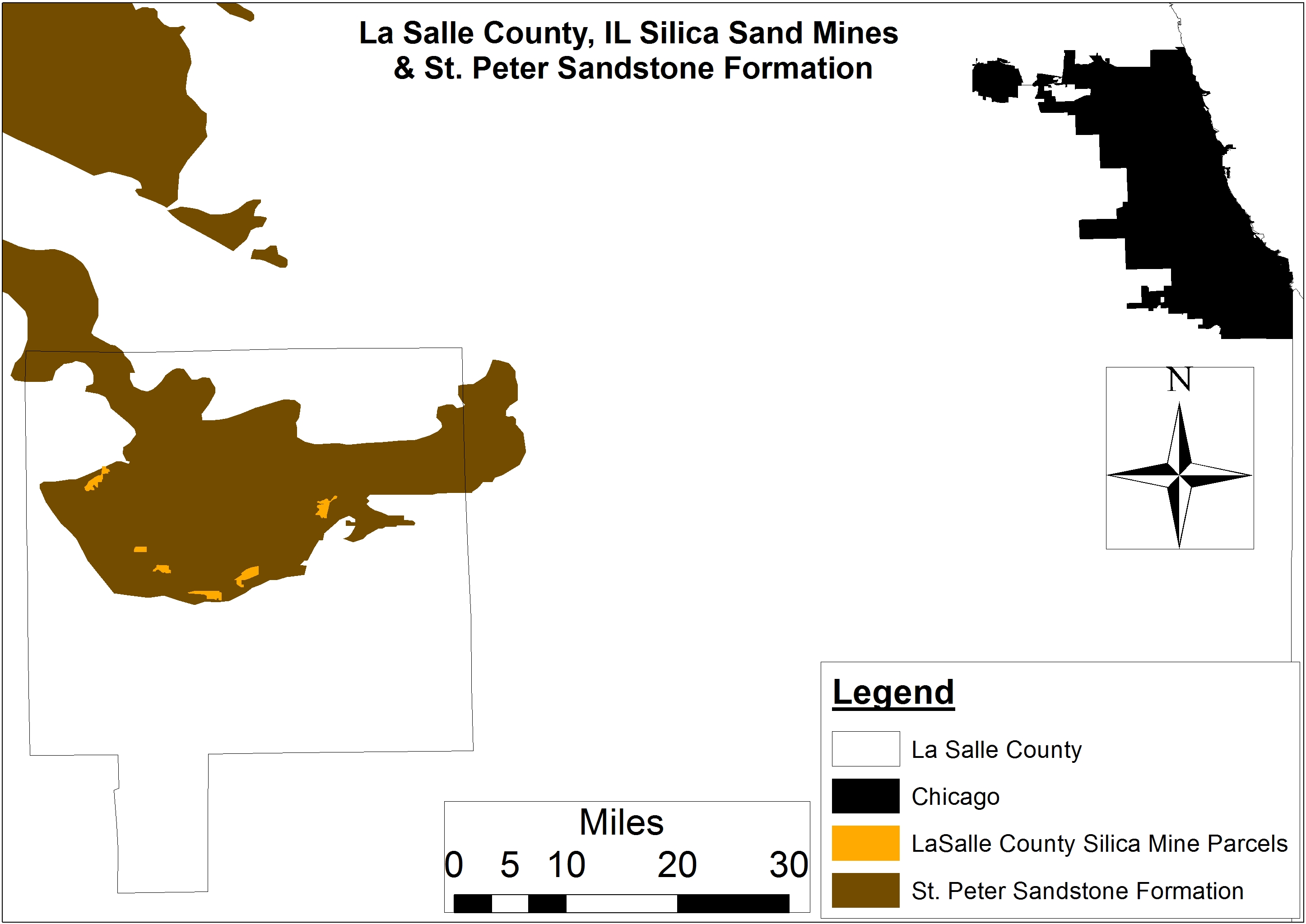
LaSalle County, Illinois
May 24 & 26, 2018
Frac Sand Mines and The Nature Conservancy’s Nachusa Grasslands Buffalo Herd, Franklin Grove, Illinois
Fast forward to the week of May 21st of this year, and I was back in the frac sand capital to interview several folks that live near these mines or have been advocating for a more responsible industry. I conducted a “morning flight” with several journalists and county officials from neighboring Ottawa County.
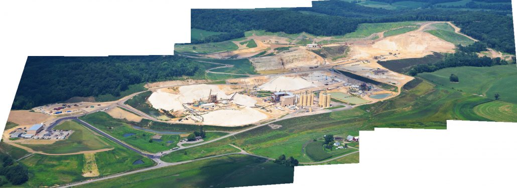
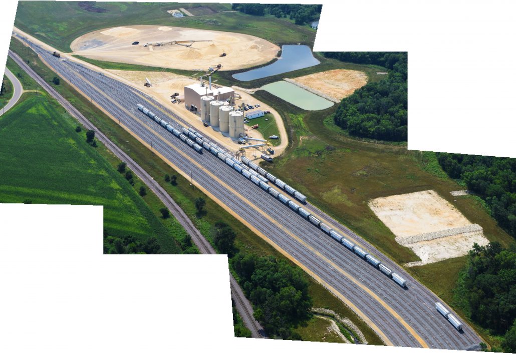
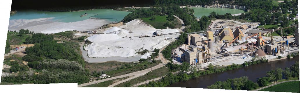
LaSalle County is an extremely interesting case study for anyone even remotely interested in the food, energy, and water (FEW) conversation that has begun to receive significant attention in the age of the “Shale Revolution.” (Such focus is largely thanks to the extreme amounts of water required during the fracking process.) While LaSalle County has never experienced even a single HVHF permit, it is home to much of the prized silica or “proppant” the HVHF industry prizes. La Salle receives this recognition due to its location above one of the finest sources of silica sand: the St. Peter Sandstone formation. This situation has prompted a significant expansion in the permitting of new silica sand mines and expansion of existing mines throughout the county – from small townships like North Utica and Oglesby to Troy Grove 7 miles north on East 8th Road.
Meanwhile, LaSalle County is home to some of the most productive soils in the United States, due largely to the carbon sequestration capabilities of the tallgrass prairies that once dominated the region. In any given year, the county ranks in the top 5 nationally based on the amount of soybean and corn produced on a per-acre basis. According to an analysis of the most recent USDA agricultural census, total agricultural value in LaSalle County exceeds $175 million or seven times the national average by county of roughly $23 million.
Needless to say, the short-term extraction of silica sands in the name of “energy independence” stands to have a profound impact on long-term “food security” in the U.S. and worldwide. Sadly, this conflict is similar to the one facing the aforementioned West Central Wisconsin, home to similarly productive soils. The cows that feed on the forage those soils produce some of the highest quality dairy anywhere. (As an aside: both regions are facing the realities of their disproportionate support for Donald Trump and the effects his trade war will have on their economies.)
… vertical walls of moss-covered stone formed by glacial meltwater that slice dramatically through tree-covered sandstone bluffs. More than 13 miles of trails allow access to waterfalls, fed season runoff or natural springs, sandstone overhangs, and spectacular overlooks. Lush vegetation supports abundant wildlife, while oak, cedar and pine grow on drier, sandy bluff tops. – IL DNR
Starved Rock receives more than 2.5 million visitors annually, which is the most of any Illinois state park. However, it is completely surrounded by existing or proposed frac sand mines, including US Silica’s Covel Creek mine. US Silica even recently pitched an expansion to the doorstep of Starved Rock and future plans to nearly engulf the park’s perimeter. What such an expansion would do to the attractiveness of the park and its trickle down economic impact is debatable, but LaSalle County residents Paul Wheeler and photographer Michelle McCray took a stab at illustrating the value of the state park to residents for our audience back in August, 2016:
Our flight with LightHawk pilot and neighboring Mazon, Illinois retired farmer Doug Harford lifted off from Illinois Valley Regional Airport (KVYS) at around 9:00 a.m. local time on the morning of May 24th. We had perfect conditions for taking photos, with no clouds and a comfortable 70-75°F for the duration of a two-hour flight. We covered nearly 200 square miles and ten existing, abandoned, or permitted frac sand mines.
Explore details from our Illinois tour by clicking on the images below:
All passengers were struck by how large these mines were and how much several of the mines had expanded since the last time we all flew over them in June of 2016. The mines that had experienced the greatest rates of expansion were US Silica’s LaSalle Voss mine along Interstate 80 and the aforementioned Illinois River mine along with Fairmount Mineral’s major expansion, both in terms of infrastructure and actual mine footprint, in Wedron along the Fox River.
Figure 3. A map of the LaSalle County frac sand mines and associated St. Peter sandstone formation, along with the city of Chicago for some geographic perspective.
Most of this expansion is due to three critical distinguishing characteristics about the industry in LaSalle County:
The processing and export infrastructure (i.e., east-west rail) is in place and allows for mining to take place at times when other sand mining regions are mothballed,
Due to the large aggregation of parcels for farming purposes, companies can lease or outright purchase large amounts of land from relatively few landowners, and
Only the largest firms are active in the region, and with economies of scale they are not subject to the same types of shocks that smaller firms are when the price of oil collapses (like it did between June 2015 and February 2016). This means that the conflict will only be amplified in the coming months and years as the frac sand mining industry looks to supersede agriculture as LaSalle County’s primary economic driver.
However, all is not lost in North Central Illinois. This hope was stoked during our sojourn – and my subsequent trip in person – up to see The Nature Conservancy’s 3,600 acre preserve in Franklin Grove on the border of Lee and Ogle counties. As someone who is working hard to establish a small plot of prairie grasses and associated wildflowers at my home outside Cleveland, I was hoping to see what an established prairie looks like from the air. My primary goal, however, was to see what a healthy herd of native bison looks like.[2] The Nachusa bison are unique in that they came:
… from Wind Cave National Park in South Dakota and…Unlike most other American bison, animals from the Wind Cave herd have no history of cross-breeding with cattle. Bison from Wind Cave are the species’ most genetically pure and diverse specimens.
We were fortunate during our flight to have spotted the heard at the western edge of the preserve in what volunteer naturalist, Betty Higby, later told me the staff calls Oak Island. While I am not a person of faith, seeing these behemoths roaming freely and doing what 20-30 million of their ancestors used to do across much of North America moved me in a way I was not prepared for. I was immediately overwhelmed with a sense of awe and humility. How was I going to explain this beast’s former ubiquity and current novelty to my 5-year-old son, who shares a love of the North American Bison with me and would most certainly ask me what happened to this majestic creature?
Medina & Stark counties, Ohio NEXUS Pipeline flight
June 25, 2018
Ohio is currently home to 2,840 fracking permits, with 2,370 of these laterals having been drilled since September 2010. The growing concern around the fracking and petrochemicals conversation across much of the Midwest is the increasing number of FERC-permitted natural gas pipeline “proposals”[3] the industry is demanding it needs to maximize potential. Most residents in the path of these pipelines have strong objections to such development, citing the fact that imminent domain should not be invoked for corporate gain.
Much like all of the other patterns and processes we’ve documented and/or photographed at FracTracker, we felt that a flight over the latest FERC-approved pipeline – The NEXUS pipeline – would give us a better understanding of how this critical piece of infrastructure has altered the landscapes of Medina and Stark counties. Given the population density of these two northeastern Ohio counties, we also wanted to document the pipeline’s pathway with respect to urban and suburban centers.
Our flight on June 25th was delayed due to low clouds and last minute changes to the flight plan, but once we took off from Wadsworth Municipal Airport (3G3) with a local flight instructor it was clear that NEXUS is a pipeline that navigates a sinuous path in cities and townships like Green, Medina, Rittman, and Seville – coming dangerously close to thousands of homes and farms, as well as many schools and medical facilities.
Explore details from our NEXUS Pipeline tour by clicking on the images below:
Will this be the last FERC-approved pipeline to transverse Ohio in the name of “energy independence”? Will this pipeline and its brethren with names like the Utopia and ET Rover be monitored in real-time? If not, why? It is unfortunate, to say the least, that we so flippantly assume these pipelines are innocuous given their proximity to so many Ohioans. And, as if to add insult to injury, imminent domain is invoked. All this for a piece of oil and gas infrastructure that will profit companies on the global market, with only a fraction of the revenue returning to affected communities.
What’s Next?
I don’t know of a better way to understand the magnitude of these pipelines than flying over them at 1,000-1,500 feet, and I will continue to monitor and photograph oil and gas developments from the air with the assistance of amazing pilots like those affiliated with LightHawk and SouthWings.
To this end, I will be returning to West Central Wisconsin for yet another “morning flight” with the aforementioned La Crosse-area pilot and lawyer Tim Jacobson and frequent collaborator University of Wisconsin-Stout professor Tom Pearson.[4] Our flight plan will return us to the northern Wisconsin frac sand counties of Chippewa, Barron, Dunn, Eau Claire, and if we have time we’ll revisit the mines we photographed in August of last year. We’ve been told by Susan Bence, an environmental reporter out of Milwaukee Public Radio, that she is trying to convince the powers that be at NPR in Washington, DC that this is a story the entire country should hear about. Wish us luck!
Flyover Partners
By Ted Auch, Great Lakes Program Coordinator
Bird’s-Eye-View Endnotes
The first of my morning fracking flights was out of this airport back in June, 2012 along with the other passenger on this flight Paul Feezel of Carroll Concerned Citizens and David Beach of the Cleveland Museum of Natural History’s Green City Blue Lakes program.
The Conservancy initially brought at least 30 bison of different ages and genders to Nachusa. The bison graze on approximately 1,500 acres of the prairie and the site currently supports more than 120 bison according to site volunteer naturalist Betty Higby.
I put quotes around this word because in my travels across Ohio interviewing those in the path of these transmission pipelines it is clear that this is not the correct word because ‘proposals’ implies that these pipelines might not happen or are up for debate. Yet, neither could be further from the truth with most folks indicating that it was very clear very early in their interactions with FERC and the pipeline companies that there was never a chance that these pipelines were not going to happen with “imminent domain for private gain” being the common thread throughout my conversations.
Tom is the author of a recently published book on the topic “When the Hills Are Gone.”
https://www.fractracker.org/a5ej20sjfwe/wp-content/uploads/2018/07/Sand-Flyover-Feature.jpg400900Ted Auch, PhDhttps://www.fractracker.org/a5ej20sjfwe/wp-content/uploads/2025/09/2025-Wordmark-Logo.pngTed Auch, PhD2018-08-08 10:31:522021-04-15 14:57:41Documenting Fracking Impacts: A Yearlong Tour from a Bird’s-Eye-View
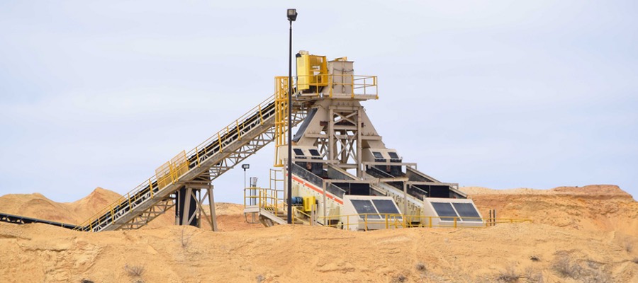
Surface mining to obtain sand that is perfectly sized for use in the hydraulic fracturing process has been increasing in recent years. Over the summer, FracTracker had the opportunity to document a number of sand mining activities occurring in Michigan, Minnesota, and Wisconsin that supply frac sand to the oil and gas industry. Explore a selection of this imagery below:
Explore these and other frac sand mining photos and videos in our online album. The most recent imagery can be found at the bottom of the album. Additional videos are also available on this YouTube channel.
View All Albums
All of these frac sand photos, and more, can also be found on our Energy Imagery page, organized by topic and also location.
If you have photos or videos that you would like to contribute to this growing collection of publicly available information, just email us at info@fractracker.org, along with where and when the imagery was taken, and by whom.
https://www.fractracker.org/a5ej20sjfwe/wp-content/uploads/2017/09/Frac-sand-mining-Aug2017-Feature.jpg400900FracTracker Alliancehttps://www.fractracker.org/a5ej20sjfwe/wp-content/uploads/2025/09/2025-Wordmark-Logo.pngFracTracker Alliance2017-09-12 20:48:512021-04-15 15:02:34New frac sand mining photos and videos are now available via FracTracker
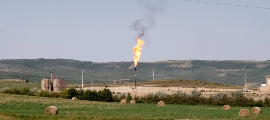
North Dakota is now in its third oil boom due to the drilling technologies of horizontal drilling and hydraulic fracturing that have made once-inaccessible oil accessible. The Bakken formation covers western North Dakota, eastern Montana, and parts of Manitoba and Saskatchewan. At the height of the boom in 2014, just under 12,000 wells were active across the west, extracting 1.1 million barrels (bbl) of oil per day and flaring at 32%. The boom has bumped North Dakota to the second largest oil and gas producing state, second only to Texas.
Dakota Resource Council (DRC) is a member-led, grassroots organization that has been working in extraction-impacted communities in North Dakota since 1978. DRC’s members work on oil and gas campaigns that aim to eliminate impacts to land, air, water, and livelihoods of the citizens of North Dakota. Campaign issues on oil and gas industry damage include: flaring, pipelines, radioactive/oilfield waste, state accountability, and oil-by-rail.
The following photos from DRC show impacts of current and legacy oil and gas extraction in western North Dakota – an area in the heart of the Bakken that is historically a rich agricultural and ranching region. The vast contrast between the two industries are not complementary.
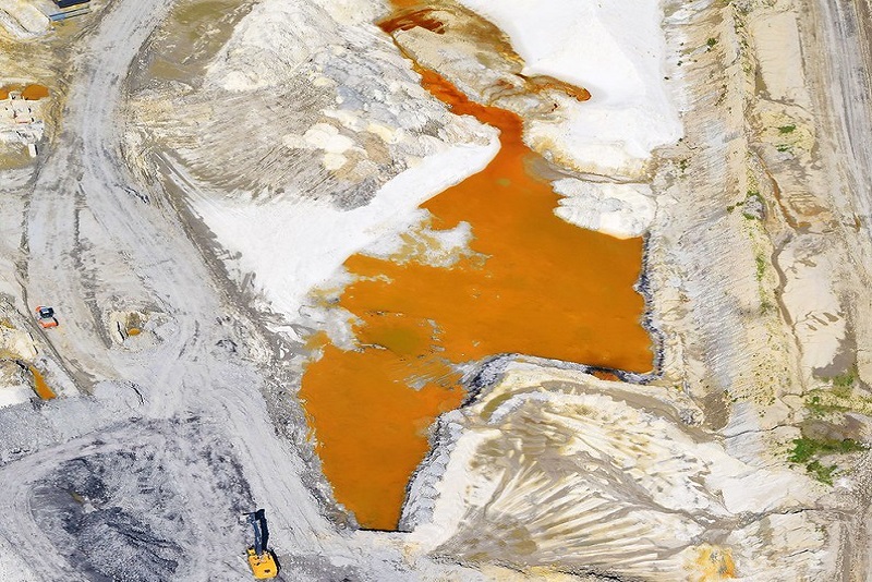
Bear Den Bay Incident
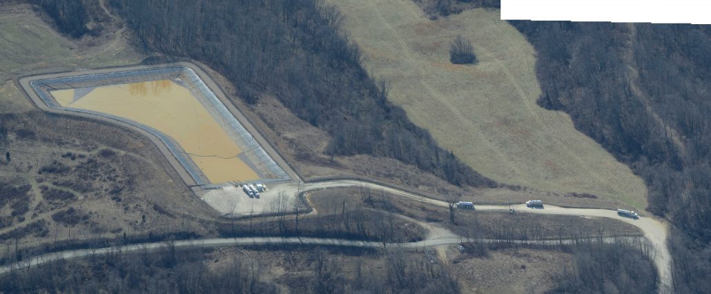
Fort Berthold Indian Reservation is the epicenter of fracking in the Bakken. On July 8, 2014 a wastewater pipeline rupture was accidentally discovered in rural Mandaree on the reservation. The pipeline is owned by Crestwood Midstream, LLC – a Texas-based company.
An estimated 1 million gallons of toxic saltwater ran down a ravine, ending up in the tributary of Bear Den Bay, which is located ¼ mile from the city of Mandaree’s water intake. The spill was contained, but the state doesn’t know exactly how much waste went into the bay. Tribal administration released a statement that beaver dams prevented the fluids from reaching the lake.
Weeks after the incident Crestwood released a statement saying:
… while assessment of the effect is ongoing, examination and testing to date show that an area of grass, brush and trees about 200 yards long sustained damage. Some produced water ran down a ravine into natural pools in a small stream at the bottom, but it appears that the produced water stopped there… The impact on fish and wildlife appears to have been minimal, in fact beavers, turtles, frogs, deer and pelicans have been seen returning to and re-inhabiting the impacted area.
To date, there has been no penalty for the damage that has been done to the land and reclamation is ongoing. Below are photos documenting the incident’s effects:
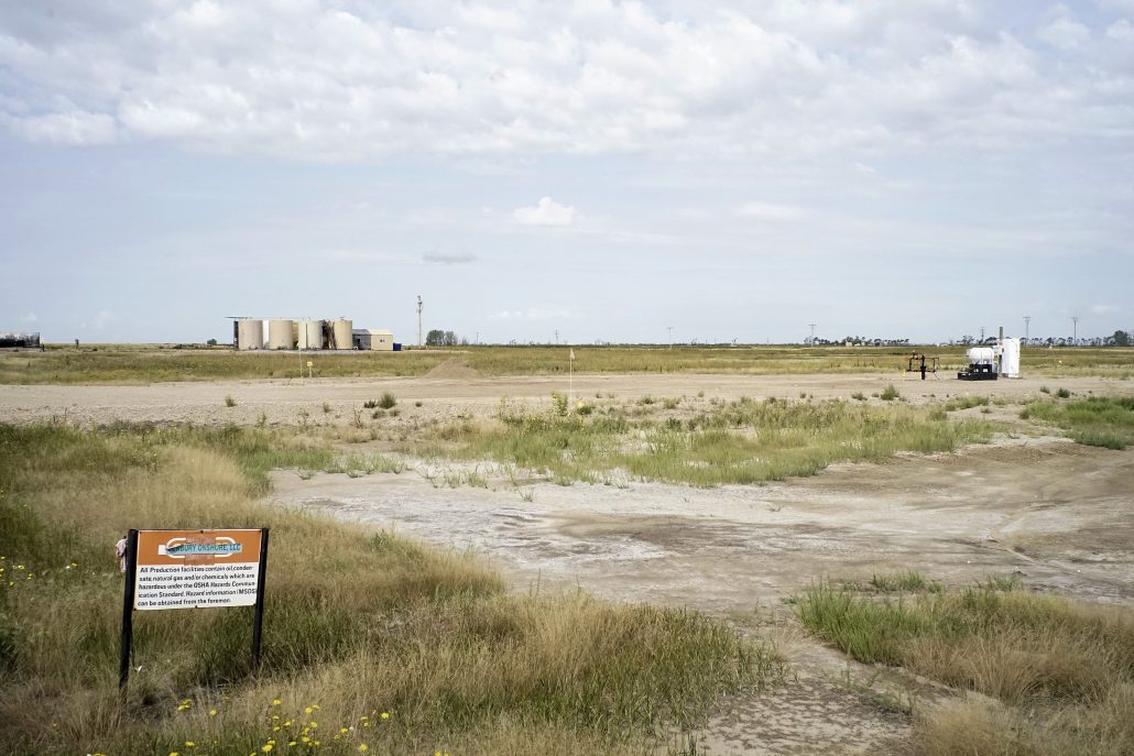
Western North Dakota has weathered through two previous oil booms in the early 1950’s and 1980’s. Previous booms left behind infrastructure that sits abandoned today. Due to hydraulic fracking technology, once-inaccessible oil is now accessible. These pre-existing wells are called legacy wells, that produce roughly 5% of North Dakota’s 1.2 million barrels per day.
Much of these wells contain infrastructure that has been in place for over 60 years. Pipelines have not been mapped or regulated in North Dakota until recently. Farmers are finding underground tanks and pipelines filled with toxic sludge. Just like previous oil booms, North Dakota was not prepared for the cost of extraction. Scroll through the following gallery showing a variety of legacy sites in ND.
https://www.fractracker.org/a5ej20sjfwe/wp-content/uploads/2016/10/ND-Flaring-DRC-Feature.jpg400900Guest Authorhttps://www.fractracker.org/a5ej20sjfwe/wp-content/uploads/2025/09/2025-Wordmark-Logo.pngGuest Author2016-10-20 11:10:332021-04-15 15:04:23Documenting Oil and Gas Industry Damage in North Dakota
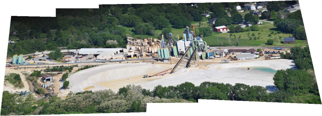
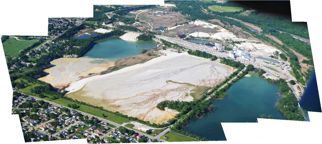
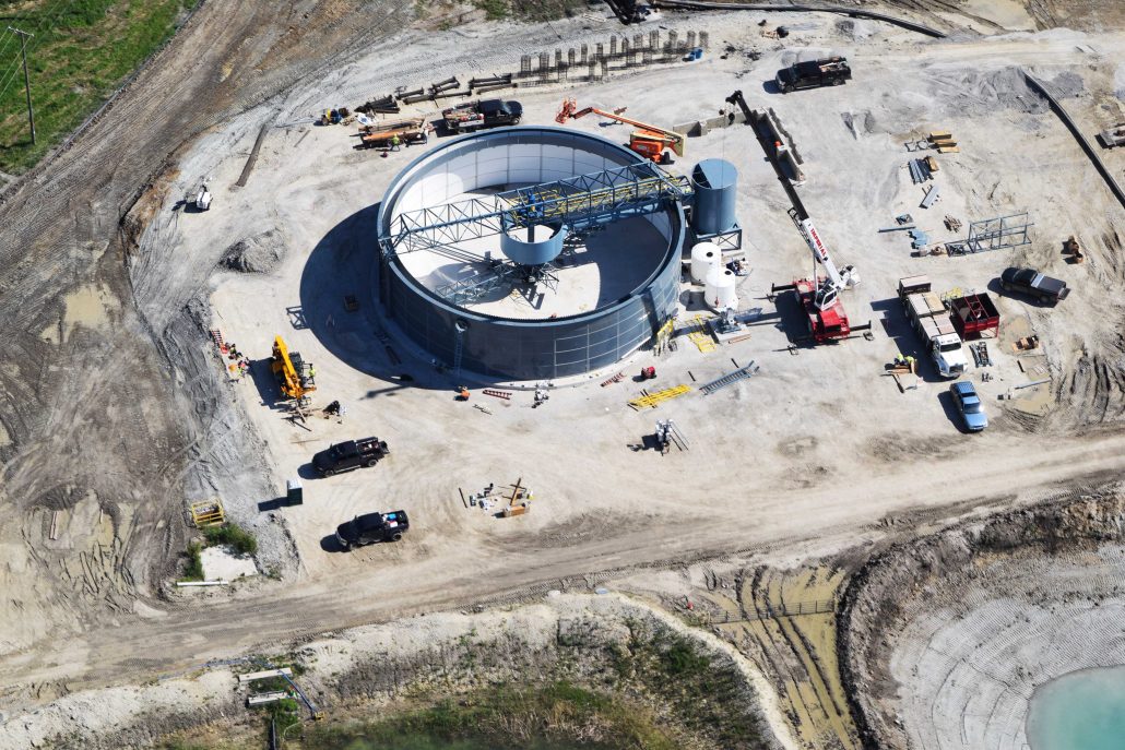
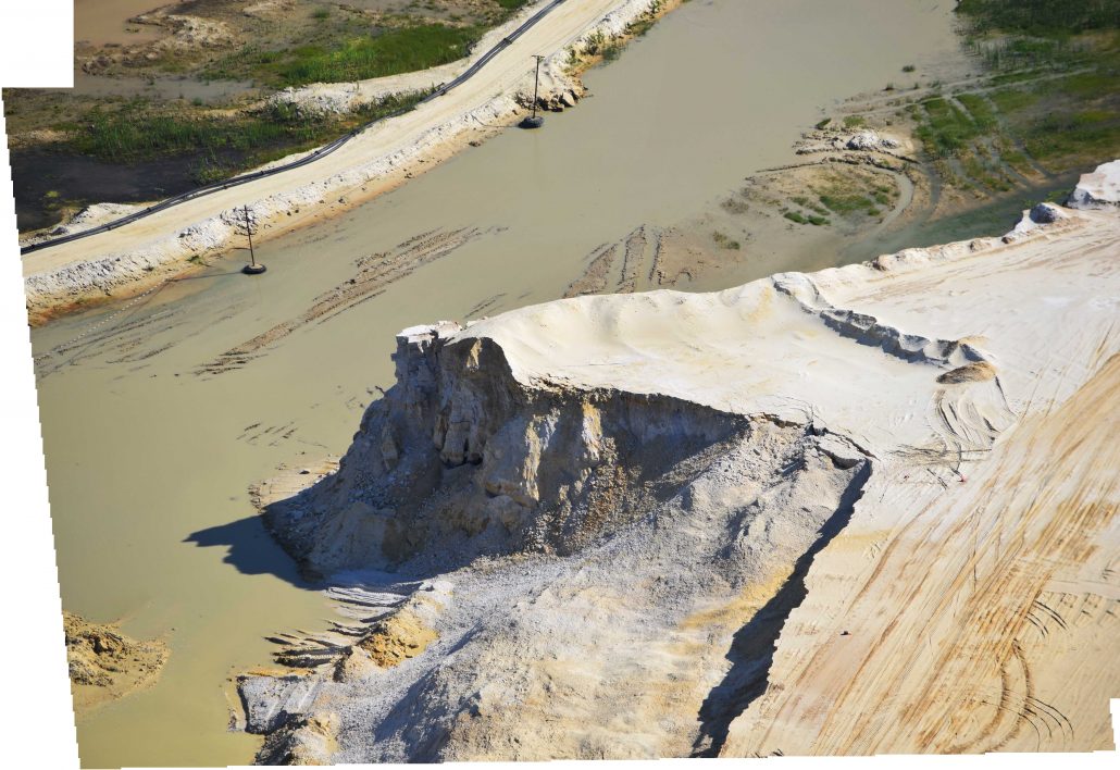
With the advent of hydraulic fracturing to increase production of oil and gas from tight geologic formations, such as shale, the demand for fracking sand (frac sand, or frack sand) has increased drastically in recent years. What does this process look like, you might ask. To help you understand this subsidiary of the oil and gas industry, we’ve compiled all of our frac sand photos into three albums on the topic.
Frac Sand Mining Photo Album
This album contains all of the photos we have amassed of frac sand mining and transportation operations – both from the ground and the sky.
All of these frac sand photos, and more, can also be found on our Energy Imagery page, organized by topic and also location.
If you have photos or videos that you would like to contribute to this growing collection of publicly available information, just email us at info@fractracker.org, along with where and when the imagery was taken, and by whom.
https://www.fractracker.org/a5ej20sjfwe/wp-content/uploads/2016/09/SandMining-Feature.jpg400900FracTracker Alliancehttps://www.fractracker.org/a5ej20sjfwe/wp-content/uploads/2025/09/2025-Wordmark-Logo.pngFracTracker Alliance2016-09-20 16:33:572021-04-15 15:04:26Frac Sand Photos Available on FracTracker.org


