 Jared Durelle
Gas Storage Plan vs. Indigenous Rights in Nova Scotia
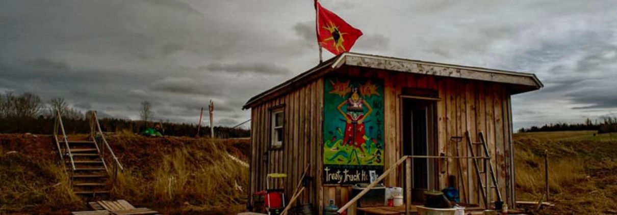
The Mi’kmaq First Nations people are facing threats to their lands and water due to plans in Nova Scotia proposed by AltaGas.
The Mi’kmaq First Nations people are facing threats to their lands and water due to plans in Nova Scotia proposed by AltaGas.

Information on which bird species in northeastern Pennsylvania are affected by the fracking industry’s expansion.

For the past four decades, groups of Alaska Natives including the Gwich’in and Iñupiat, international institutions including the United Nations and the Inter-American Commission on Human Rights, the US government, the state of Alaska, and environmental groups have debated whether or not oil extraction should be allowed in the Arctic National Wildlife Refuge (ANWR).
Made up of 19.3 million acres in northeastern Alaska, ANWR is an area with great cultural significance and ecological richness. Fossil fuel extraction poses significant material, reputational, and human rights risks according to the Gwich’in Steering Committee, a group formed in 1988 in response to proposals to drill for oil in the coastal plain of ANWR, or what they call the Sacred Place Where All Life Begins, Iizhik Gwats’an Gwandaii Goodlit.
In the past few months, the Trump administration issued nine leases, the first ever in the Arctic refuge’s coastal plain, even as major oil companies skipped out on bidding in the area and all major U.S. and Canadian banks pledged not to fund fossil fuel development in the Refuge. The sale was a major flop, which points to the larger movement away from fossil fuels, an inevitable transition reinforced by President Joe Biden’s 60-day moratorium on oil and gas leasing on federal lands.
But despite efforts to protect ANWR, leases that went through under the Trump administration threaten to further violate human rights and damage wildlife.
Described as “North America’s Serengeti,” ANWR is the continent’s most intact and remote wilderness environment, a landscape of fragile tundra ecosystems and diverse wildlife. The Refuge is home to more than 40 fish and mammal species and over 200 bird species. Though harsh, the landscape exists in a delicate balance. Specially-adapted plant species thrive during long winters and short growing seasons, supporting annual wildlife migrations and hibernations, ecosystem functions, and a wealth of natural resources.
Of particular significance is Area 1002, mapped in Figure 2 below. The 1.5-million-acre area site within ANWR sits between the north slope of the Brooks Range in Alaska and the Beaufort Sea, and is the summer calving and feeding site of the Porcupine caribou, and a site sacred to the Gwich’in Tribe.
The Porcupine caribou herd has travelled the 1,500-mile trek, the longest documented terrestrial mammal migration in the world, to gather there for at least the past 23,000 years.
The herd is one of the area’s keystone species (i.e., if it were removed from the ecosystem, the landscape’s functional integrity would suffer and drastically change). The 125,000-strong herd plays a key ecological and cultural role in the Refuge, and the distribution and health of the herd is a direct indicator of the health of the entire ecosystem. Their annual journey provides them with good forage and relief from predators and mosquitos.
Oil and gas development could interfere with the Caribou herd’s migrations as industrial disturbances discourage the instinctual movements of pregnant and nursing caribou mothers – especially problematic given their slow reproductive rate – and could diminish the population.

The Porcupine caribou herd in the Arctic National Wildlife Refuge (ANWR), Alaska. Photo courtesy of NWF Blogs, 2015.
ANWR is also the site of oil fields, estimated by the US Geologic Survey in 2001 to contain between 11.6 to 31.5 billion barrels of oil (BBO) versus the 1987 estimate of 4.8 to 29.4 BBO, (95- and 5-percent probabilities) and mean values are 20.7 BBO versus 13.8 BBO (current assessment compared to 1998 assessment). and natural gas liquids (NGLs).
Opponents of drilling in the Arctic – including Indigenous groups, environmental organizations, and scientists – say these figures are outdated and that environmental and public health risks far outweigh any revenue. Proponents claim drilling here would significantly reduce prices and US foreign oil dependence, but such assertions are highly suspect. Market projections have shown that oil and gas exploration and production in ANWR’s North Slope would not increase US energy security or lower gas prices. Resource uncertainty and decreasing demand for fossil fuels nationally reveal a market that lures fewer and fewer investors.
For millennia, the northern Alaskan alpine tundra has been home to Native communities – including the Gwich’in, Hare, Iñupiaq, and Koyukon, who have a legacy of living sustainably in this complex, fragile, and sometimes very demanding, environment (see Figure 1). The health and wellbeing of these communities is intricately tied to the health of the environment surrounding them.
Along Alaska’s coast, outside of ANWR between Prudhoe Bay and Barrow (Utqiagvik) where oil and gas extraction is happening already, the current environmental damage from oil and gas extraction is undeniable. Extractive activities have disconnected wildlife corridors and negatively affected subsistence hunting, and the local tourism industry oriented around polar bear and whale viewing opportunities has suffered.
Though the issue has divided Alaskan communities, all those living in and around ANWR will likely face challenges borne of further oil and gas development.
Alaska’s Native peoples have led a decades-long fight to protect the area from unsustainable oil and gas development. This industry brought jobs, but introduced significant change to the way of life on the North Slope of the Athabaskan Gwazhał (Brook’s Mountain Range). Corporate profit has, in some locations, superseded the rights for health and safety of the Native people of this region.
This map shows the Arctic National Wildlife Refuge in the context of oil fields; Native Alaskan language groups in Alaska and eastward into Canada; along with the habitats of the Central Arctic, Western Arctic, and Porcupine caribou herd — a species held sacred by the Gwich’in people. Please note that the Native Alaskan language group territories should be interpreted somewhat loosely, as it’s difficult to estimate the precise location and distinction between groups. See Figure 2 for a detailed map of the oil fields.

Figure 1: Language groups and natural features of the North Slope of Alaska, FracTracker Alliance, January 2021. Language boundaries were taken from the Alaskan Native Language Center, and data from Alaska DCRA Data. Boundaries of these caribou herds are fluid, and may change from year to year. Caribou herd boundaries digitized by FracTracker from compiled images compiled from U.S. Fish and Wildlife Service, Western Arctic Caribou Herd Working Group, and Wikipedia. Oil and gas area boundaries digitized by FracTracker from compiled images from North Slope Borough: Department of Planning & Community Services, and the U.S. Geological Survey (USGS). Alaska ecoregions (including Coastal Plain) from USGS (link is a direct data download).
President Trump claimed that the January 6, 2021, lease sale’s potential revenue would offset the costs of major 2017 tax cuts.
But pressure from drilling opponents – including Alaskan Natives, environmental activists, and scientists – a global recession, low oil prices, and waning faith and interest in the oil and gas sector curbed expected lease sales. Major oil companies chose to forego the auction – a sale that US banks (and some Canadian institutions) refused to bankroll. The auction received only three bidders – one of which was the State of Alaska – and generated only a fraction of the revenue it was projected to raise. Half of the parcels drew no bidders at all.
This map shows parcels purchased by three entities during the January 6, 2021 lease sale in Area 1002, a site of particular cultural and ecological importance within ANWR.

Figure 2: Results of the January 6, 2021 oil and gas lease sale in Area 1002, FracTracker Alliance, January 2021. Data layer for oil and gas lease area digitized by Karen Edelstein using a Bureau of Land Management map.
Despite the lukewarm response, the BLM received 13 bids on 11 lease tracts (symbolized in Figure 2, above, with diagonal red lines). This area spans 437,804 acres, is valued at a little over 14.4 million dollars and is estimated to contain eight billion barrels of recoverable oil.
Knik Arm Services and Regenerate Alaska each secured one parcel. Half of the sale’s revenue will go to the federal government, and half will go to the State of Alaska. The leases auctioned off are renewable and active for ten years. The BLM announced on January 19 that it signed and issued leases on nine of the 11 tracts. View the record of lease sales here.
The Trump Administration’s leasing decision followed 40 years of gridlock over oil and gas exploration and drilling in one of the nation’s most pristine environments. The timeline below outlines major developments in the struggle to protect ANWR:
1960: President Dwight Eisenhower establishes an 8.9-million-acre expanse in Alaska’s tundra as the nation’s first ecosystem-scale conservation area, specifically for its “unique wildlife, wilderness, and recreational values.”
1972: The Arctic Slope Regional Corporation (ASRC) was recognized under the Alaska Native Claims Settlement Act, which transferred 44 million acres to Indigenous control and instigated the creation of 12 regional, private, for-profit companies intended to represent and protect Indigenous business interests and their ownership of the land and its resources.
1977: Margaret Murie, American naturalist, author, adventurer, and conservationist and recipient of the Presidential Medal of Freedom stood before Congress on behalf of the Arctic National Wildlife Refuge, testifying to why we must defend our last wild places.
1980: President Jimmy Carter signs into law the Alaska National Interest Lands Conservation Act (ANICLA), which expands the protected area to 19.3 million acres and renames it the Arctic National Wildlife Refuge (ANWR). The Act mandates that potential oil reserves in the 1.5-million-acre Coastal Plain be considered for development only with Congress’ authorization.
1987: Under President Ronald Reagan, an Environmental Impact Statement (EIS) for ANWR’s oil and gas exploration is drafted, and the US Department of Interior recommends Congress open the Coastal Plain for exploration.
2002 – 2003: During President George W. Bush’s Administration, the House repeatedly approves drilling in ANWR – only to be met with the Senate’s rejection.
2012: The Gwich’in people present and defend a Resolution to Protect the Birthplace and Nursery Grounds of the Porcupine Caribou Herd to Congress and the President. The Resolution recognizes and affirms their right to continue and protect their way of life and the protection of the caribou they revere and depend on.
2015: President Barack Obama’s Administration releases the U.S. Fish & Wildlife Service’s Comprehensive Conservation Plan for ANWR, calling for core areas – including the Coastal Plain – to be designated as wilderness, the highest level of protection for public lands.
2017: Following House instructions, the Senate Energy & Natural Resources Committee legislates $1 billion in revenue creation between 2018 – 2027, and to that end, passes an ANWR drilling provision. President Donald Trump signs the bill into law through the Tax Cuts & Jobs Act, which makes several significant changes to individual income tax and — notably – mandates energy and job creation and economic growth for future generations, through which the Trump Administration and Republican lawmakers advance fossil fuel industry expansion. The law includes the ANWR lease provision as a way to generate revenue to offset the associated tax cuts, in turn opening up the Coastal Plain to drilling.
April, 2018: Gwich’in Council International (GCI) publishes Impact Assessment in the Arctic: Emerging Practices of Indigenous-led Review, identifying the strategic approaches Indigenous governments are taking as they lead their own major project assessment.
“Gwich’in Council International (GCI) represents 9,000 Gwich’in in the Northwest Territories (NWT), Yukon, and Alaska as a Permanent Participant in the Arctic Council; the only international organization where Indigenous peoples have a seat at the decision-making table alongside national governments. GCI supports Gwich’in by amplifying our voice on sustainable development and the environment at the international level to support resilient and healthy communities.”
December, 2018: The Trump administration’s Bureau of Land Management (BLM) released a draft environmental impact statement (DEIS) for oil and gas leasing in ANWR. Many opposed the DEIS as a violation of indigenous rights. The Center for American Progress analyzed public opinion concerning drilling in the refuge and found that an overwhelmingly majority opposed to drilling the refuge. Of the 1 million comments submitted in response to the draft EIS, 99 percent opposed the proposed oil and gas activity.
March 26, 2019: Gwich’in leaders from across the United States and Canada were joined by faith leaders, scientists, and veterans to stand before Congress and testify on behalf of the Arctic National Wildlife Refuge and its coastal plain, and to support passage of The Arctic Cultural and Coastal Plain Protection Act. Witnesses included Ms. Bernadette Demientieff, Executive Director, Gwich’in Steering Committee; The Honorable Galen GilbertChief, Arctic Village Council; The Honorable Dana Tizya-Tramm, Chief, Vuntut Gwitchin First Nation; The Honorable Victor Joseph, Chief/Chairman, Tanana Chiefs Conferece; Mr. Sam Alexander, Board Member, Gwich’in Council International; Mr. Fenton Rexford, Advisor to the Mayor of the North Slope Borough, Tribal Member, Native Village of Kaktovik; Rev. Mark Lattime, Bishop of Alaska, The Episcopal Church; Dr. Steven Amstrup, Chief Scientist, Polar Bears International; Mr. Chad Brown, Founder, Soul River, Inc.; Mr. Richard Glenn, Executive Vice President, External Affairs, Arctic Slope Regional Corporation; Mr. Matthew Rexford, Tribal Adminisrator, Native Village of Kaktovik.
October 2019: The Gwich’in Steering Committee, Cultural Survival, Land is Life, First Peoples Worldwide, and the American Indian Law Clinic at the University of Colorado submitted a report to the the United Nations Human Rights Council. In the report, “Observations on the State of Indigenous Human Rights in the United States of America,” groups state that “The government of the United States has repeatedly failed to protect the human rights of the Gwich’in by aggressively pursuing oil and gas development in the Coastal Plain of the Arctic National Wildlife Refuge without first obtaining the Free, Prior and Informed Consent of the Gwich’in Nation.”
September 2020: Fifteen states sue the Trump Administration over drilling in ANWR, and two more lawsuits from environmental and social justice organizations and Indigenous groups assert that oil operations would violate the rights of Indigenous populations and threaten the landscape and wildlife it sustains. BLM withdraws approximately 460,000 acres from the plan after extensive comment and protest from Alaskan Natives, environmental nonprofit organizations, and the Canadian government, though the majority of the leases remain on the table.
In the same month, the U.S. Department of the Interior (DOI) released the Final Environmental Impact Statement (EIS) for the Coastal Plain Oil and Gas Leasing Program. Its release was a clear suppression of science and public opinion.
U.S. Secretary of the Interior David Bernhardt made the following dubious claims: “Affordable energy and great paying energy jobs help power our nation’s economy, which is clearly thriving under President Trump’s policies,” stated. After rigorous review, robust public comment, and a consideration of a range of alternatives, today’s announcement is a big step to carry out the clear mandate we received from Congress to develop and implement a leasing program for the Coastal Plain, a program the people of Alaska have been seeking for over 40 years.”
December 2020: The Gwich’in Steering Committee, including Tribal Governments and Village Councils, and more than a dozen conservation groups seek a temporary restraining order and preliminary injunction prohibiting Trump from approving and issuing oil and gas leases along the Coastal Plain. The filing asserts that it is well-known and documented that seismic exploration would cause irreparable harm to the landscape, its biodiversity, and its people, as well as their tribal archaeological and cultural resources – negative impacts that go beyond the lease tracts granted to purchasers, because it promises rights-of-way and easements that breach parcel boundaries.
January 5, 2021: The day before the lease auction, an Alaskan judge denies the lawsuit from Indigenous and environmental groups arguing that the lease sales were based on inadequate, outdated environmental review. The judge claims the group didn’t provide enough evidence of environmental transgressions to warrant an injunction.
“This is bum news but it’s not going to stop us from fighting to protect it,” said Bernadette Demientieff, chair of the Gwich’in Steering Committee that brought the lawsuit. “This is sacred land to the Gwich’in. This is our way of life, and we’re not going to just allow anyone to come in and destroy our way of life, because our children are going to be the ones who have to live with the destruction that they caused.”
January 6, 2021: President Trump opens up the lease sale in a public auction hosted and streamed live on the BLM website.
January 19, 2021: On their last full day in office, the Trump Administration announces it had officially issued oil and gas leases in ANWR. The outgoing administration also tried to push through a law requiring banks to finance many industries, including oil and gas companies and assault weapons manufacturers, that major institutions – counting JP Morgan Chase and Goldman Sachs – announced they would no longer finance.
January 20, 2021: President Joe Biden signed 17 executive orders his first day in office – 30 in the first three days – that reverse several of his predecessor’s environmentally-damaging policies . Biden directed the Secretary of the Interior to “place a temporary moratorium on all activities of the Federal Government relating to the implementation of the Coastal Plain Oil and Gas Leasing Program, as established by the Record of Decision signed August 17, 2020, in the Arctic National Wildlife Refuge. The Secretary shall review the program and, as appropriate and consistent with applicable law, conduct a new, comprehensive analysis of the potential environmental impacts of the oil and gas program.”
Subsequently, the Department of the Interior issued Secretarial Order No. 3395, implementing a 60-day suspension of new oil and gas leasing and drilling permits for federal land and water.
On the same day, one of the preexisting lease holders, 88 Energy, published an update related to its operations on the North Slope of Alaska, stating plans to extract oil from the Coastal Plain by drilling directionally into the land from state land.
The Gwich’in Steering Committee released the following statement in response: “The Gwich’in Steering Committee opposes all forms of development and calls on Regenerate Alaska and its parent company, 88 Energy, to halt its plans.”
January 27, 2021: Biden issues a pause on oil and gas leasing in non-tribal federal lands and offshore waters, which lengthened the 60-day moratorium issued the week prior. He also ordered the creation of an interagency working group to prioritize economic revitalization of communities dependent on fossil fuels, and to focus on transitioning these workers to cleaner energy industries.
“We’re not going to lose jobs; we’re going to create jobs,” Biden said in his remarks about this executive order. Republicans criticized this move, saying it will eliminate jobs and hurt US businesses, but Biden’s order didn’t apply to all permitting. He added, “We’re not going to ban fracking,” a point he emphasized in his 2020 presidential campaign.
Did we miss anything? Let us know if you have important milestones to add to the timeline above!
Despite his plan to temporarily halt oil and gas leasing, Biden has approved at least 31 drilling permits since his inauguration. The Department of the Interior – whose top officials Biden put in charge of oil permitting decisions – states that the order, set to expire March 20, does not equate to a drilling permit freeze and does not apply to tribal lands. However, energy companies are still worried they may not be able to secure permits.
There are a few tactics that Biden can use to delay oil and gas exploration in ANWR, including reopening the Department of Interior’s record of decision (ROD), instituting a bid rejection, or delaying permits that companies need to search for oil and build infrastructure – though it is possible that companies could secure their leases and just wait for the administration to change (in their favor).
But if Biden wants to stick to his plan for a “just energy transition,” and advance his environmental justice, racial equity, and job creation priorities, he has to listen to Alaskan Natives and integrate their interests moving forward. Their input and right to manage their lands must be prioritized.
“We are eager to hear the Biden administration’s plan to replace the economy that it’s brought to a standstill, and look forward to working side-by-side with the President to create new, sustainable solutions,” said Voice of the Arctic Iñupiat (VOICE) President Sayers Tuzroyluk.
Voice of the Arctic Iñupiat is a nonprofit organization and communication network working across North Slope communities to address and participate in legislation, regulations, and government programs to protect their culture, and to ensure natural resource development in a safe and responsible manner.
Biden will also need to prioritize fossil fuel industry workers whose livelihoods are uncertain from his extended moratorium – for people in ANWR, and in other US communities.
Regulatory actions to open ANWR for drilling in ANWR have significant and potentially grievous implications for Alaska’s Native peoples, and do not bode well for Alaska’s air, water, and landscape, and the biodiverse species such as the Porcupine caribou that call it home.
Increased fossil fuel activity will also continue to alter the landscape and hinder its function by disconnecting migration and breeding habitat, disturbing and/or displacing animal populations, threatening their survival, and destroying the delicate ecological balance of the Coastal Plain.
However this issue is resolved, the rights of Alaskan Natives should be foremost in future decision-making and is of utmost importance to the future of their epic lands. Following their leadership, there’s hope that the solution will be equitable for both people and the environment
Gwich’in Steering Committee – The Gwich’in Steering Committee was formed in 1988 in response to proposals to drill for oil in the Sacred Place Where Life Begins, the coastal plain of the Arctic National Wildlife Refuge.
The Gwich’in Place Name and Story Atlas is an interactive Story Map that invites visitors to explore the culture, history, traditional knowledge, and land use of the Gwich’in through Gwich’in place names. The Atlas is the result of more than two decades of collaboration between the Gwich’in Social and Cultural Institute, Gwich’in Elders, and traditional land users living in the Gwich’in Settlement Region communities of Aklavik, Fort McPherson, Inuvik and Tsiigehtchic.
The Gwich’in Elders’ Biographies Research Project is a project of the Gwich’in Social & Cultural Institute’s Department of Cultural Heritage. Researchers interviewed 24 elders from the four Gwich’in communities, and collected their life histories. Many of the elders describe a very traditional lifestyle of moving seasonally on the land, being the last generation to live in this traditional manner. Their stories communicate their love and knowledge of the land, and speak to the importance of family ties, place names, legends, and historical events. They also offer snapshots of the sweeping changes the Gwich’in experienced in the 20th century.
The Right to be Cold is Sheila Watt-Cloutier’s memoir of growing up in Quebec’s Arctic on the front lines of climate change. “It is the story of an Inuk woman finding her place in the world, only to find her native land giving way to the inexorable warming of the planet.” She became one of the most influential Indigenous environmental, cultural, and human rights advocates in the world. She served as the elected Canadian president of the Inuit Circumpolar Council from 1995 to 2002, and in 2002 she was elected its international chair. She launched the world’s first international legal action on climate change through a petition to the Inter-American Commission on Human Rights.
Saqiyuq: Stories from the Lives of Three Inuit Women by Nancy Wachowich, Apphia Agalakti Awa, Rhoda Kaukjak Katsak and Sandra Pikujak Katsak offers a collection of stories from a grandmother, daughter, and granddaughter from the Baffin Island community of Pond Inlet, Nunavut. Saqiyuq is the Inuktitut word for ‘a strong wind that suddenly shifts direction.’ Their stories illustrate the shift in Inuit life from nomadic subsistence hunting to permanent settlement in communities, and offer insight into the “enforced acculturation of the Inuit and the imposition of religious and cultural values useless to Inuit culture.”
A Moral Choice: The Human Rights Implications for the Gwich’in of Drilling in the Arctic National Wildlife Refuge by the Gwich’in Steering Committee, 2005.
Alaskan Natives https://www.alaskan-natives.com/
The Northern Alaska Environmental Center https://northern.org/
Environment America https://environmentamerica.org/blogs/environment-america-blog/ame/our-decades-long-campaign-defend-arctic-national-wildlife-refuge
NRDC https://www.nrdc.org/protect-arctic-national-wildlife-refuge
The Arctic Institute https://www.thearcticinstitute.org/topics/climate-and-environment/
The Arctic Council https://arctic-council.org/en/news/environment-and-climate/
Social | Legislation & Politics | Wildlife & Ecology
The fossil fuel industry has historically taken advantage of the nation’s mineral estate for private profit, while outsourcing the public health debts of degraded environmental quality to Frontline Communities. While President Biden has recently ordered the Department of Interior to put a 60-day halt on permitting new oil and gas drilling permits on federal lands, no such policy exists for state lands in California. Governor Newsom’s administration has allowed the California Geological Energy Management Division to issue rework and new drilling permits on California state lands, bringing the total number of operational oil and gas wells on state lands up to a total of 178, almost half of which are “idle.” This number pales in comparison to the number of California oil and gas wells on federal lands; a total of 6,997 operational wells.
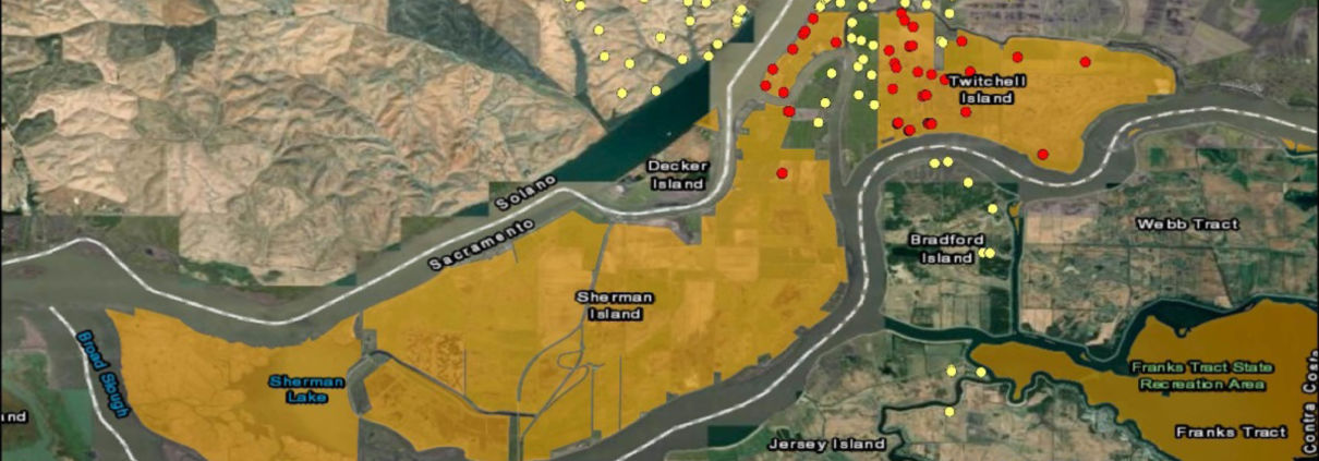
FracTracker Alliance has mapped out the operational oil and gas wells located on state lands in California, using the California Protected Areas Database. The areas containing the highest concentrations of oil and gas wells on state lands include two sensitive ecosystem environments. Figure 1 shows the 102 operational oil and gas wells located in Southern California’s Bolsa Chica Ecological Preserve. The wells are part of the Huntington Beach oil field. The preserve shares marine habitat with a marine protected area (MPA) and is habitat for numerous rare and several endangered species. More sensitive habitat also threatened by oil and gas extraction; Figure 2 shows the oil and gas production wells on the Sacramento River Delta, just upriver of the Bay Area. It is habitat for several threatened and endangered species such as the Delta Smelt and Giant Garter Snake.
California needs Governor Newsom to take a stand against the further exploitation of California’s public lands. A ban on permitting new wells on state land and a commitment to plug existing wells would set an example for Biden’s administration to make the current 60-day freeze a permanent policy.
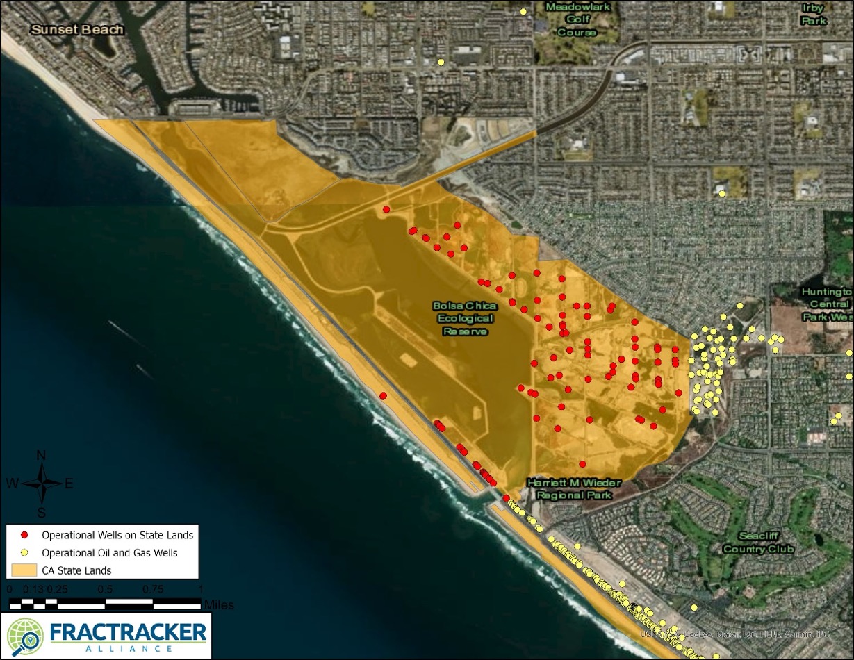
Figure 1. The Bolsa Chica Ecological Preserve hosts over 100 operational oil and gas wells that put the preserve’s ecological habitat at risk.
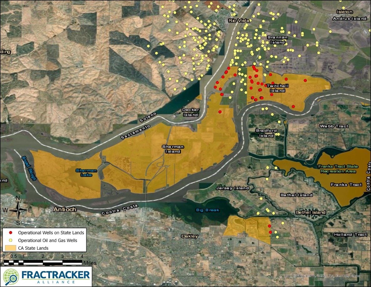
Figure 2. There are 50 operational oil and gas wells permitted on California state lands in the Sacramento River Delta.
See more California maps and articles here.
By Kyle Ferrar, Western Program Coordinator, FracTracker Alliance
By Emma Vieregge, FracTracker Summer 2020 Environmental and Health Fellow
Unconventional oil and natural gas development, or “fracking,” began in Pennsylvania in the early 2000s. Since then, over 12,000 unconventional wells have been drilled in the state, and over 15,000 violations have been documented at unconventional well sites. As fracking operations continue to expand, increasing numbers of residents have experienced significant health impacts and irreparable damage to their property. Southwest Pennsylvania in particular has been heavily impacted, with high concentrations of oil and gas infrastructure developed in Washington, Greene, and Fayette Counties.
Fracking operations have led to declining air quality, water and soil contamination, and drastic changes to the physical landscape including deforestation, habitat fragmentation, road construction, and damaged farmland. While the volume of scientific literature about the physical and mental health impacts of fracking is rising, few studies exist that specifically focus on residents’ perceptions of the changing physical landscape. The primary goal of this qualitative study was to identify residents’ attitudes about the changing physical landscape resulting from fracking operations. Furthermore, how have these landscape changes affected residents’ engagement with the outdoors and their overall health?
Many scientific studies have documented the relationship between fracking developments and mental health, and between mental health and access to green spaces and engagement with the outdoors. Peer-reviewed studies have looked at heavily fracked communities across the US, many of which focus on Pennsylvania residents. Methods typically involve one-on-one interviews, larger focus groups, surveys, or a combination of the three, to identify how living amongst oil and gas operations takes a toll on everyday life. These studies have found an increase in stress and anxiety, feelings of powerlessness against the oil and gas industry, social conflicts, sleep disturbances, and reduced life satisfaction. Additionally, residents have experienced disruptions in their sense of place and social identity. For a summary of published research about the mental health impacts from fracking, click here.
A healthy strategy many choose to cope with stress and anxiety is engagement in outdoor recreation. Having easily accessible “green spaces,” or land that is partly or completely covered with grass, trees, shrubs, or other vegetation such as parks and conservation areas have been shown to promote physical and mental health. Many scientific studies have identified significantly fewer symptoms of depression, anxiety, and stress in populations with higher levels of neighborhood green space.1 Additionally, green spaces can aid recovery from mental fatigue and community social cohesion.2 3 However, residents in Southwestern Pennsylvania may slowly see their access to green spaces and opportunities for outdoor recreation decline due to the expansion of fracking operations. Figure 1 below shows a visual representation of the interconnected relationship between fracking, access to green spaces, and negative mental health impacts.

Figure 1. The interconnected relationship between fracking operations, landscape changes and decreasing access to outdoor recreation, and negative mental health impacts.
In the last 10-15 years, fracking operations in Southwest Pennsylvania have exploded. The development of new pipelines, access roads, well pads, impoundments, and compressor stations is widespread and altering the physical landscape. Figure 2 below illustrates just one of many examples of landscape disruption caused from fracking operations.
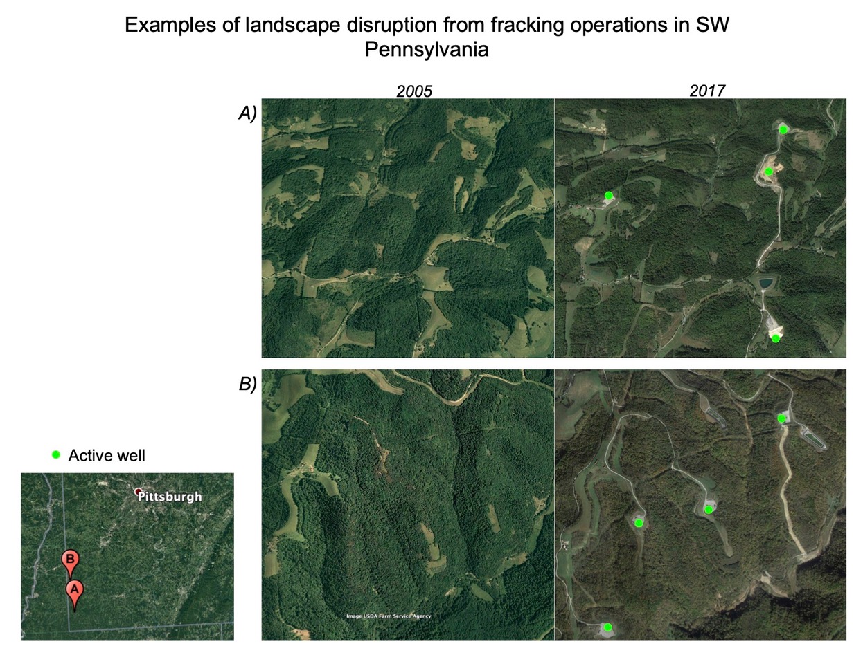
Figure 2. Examples of changes in the physical landscape caused from fracking operations in Greene County (A) and Washington County (B), Pennsylvania. Images taken from Google Earth.
Additionally, this time-slider map (Figure 3) illustrates a larger scale view of landscape changes in Greene County, Pennsylvania in a region just east of Waynesburg.
Figure 3. Time-slider map of a region in Greene County, PA where the left portion of the map is imagery from 2005, and the right portion of the map is from 2017. Active oil and gas wells are indicated by a blue pin, and compressor stations are in green.
A qualitative study was conducted to answer the following research questions:
To better understand these topics, residents living in Southwestern Pennsylvania were recruited to participate in one-on-one phone interviews, and an online survey was also distributed throughout the FracTracker Alliance network. Recruitment for the one-on-one phone interviews was accomplished through FracTracker’s social media, and email blasts through other partnering organizations such as Halt the Harm Network, People Over Petro, and the Clean Air Council. Similarly, the online survey was shared on FracTracker’s social media and also distributed through our monthly newsletter. Since this was not a randomized sample to select participants, these results should not be generalized to all residents living near oil and gas infrastructure. However, this study identifies how certain individuals have been impacted by the changing landscape brought about by fracking operations.
Eight residents completed phone interviews, all of whom resided in Washington County, PA. Residents were first asked how long they have lived in their current home, and if there was oil and gas infrastructure on or near their property. Oil and gas infrastructure was defined as well pads, compressor stations, pipelines, ponds or impoundments, or access roads. Next, residents were asked if they had any health concerns regarding fracking operations and gave personal accounts of how fracking operations have altered the physical landscape near their home and in their surrounding community. For those with agricultural land, additional questions were asked about fracking’s impact on residents’ ability to use their farmland. Lastly, residents were asked questions focused on engagement in outdoor recreation and if fracking had any impact on outdoor recreation opportunities. NVivo, a qualitative analysis software, was used identify emergent themes throughout the interviews,
In addition to the interviews, an online survey was also made available.The main purpose of the survey was to gauge where concerns about landscape changes from fracking operations fell in relation to other oil and gas impacts (i.e. air pollution, water contamination, excess noise and traffic, and soil contamination). Nine responses were recorded, and the results are discussed below. However, if you would like to add your thoughts, you can find the survey at https://www.surveymonkey.com/r/Z5DCWBD.
Various emergent themes surrounding the oil and gas industry’s impact on public health and the environment were identified throughout the resident interviews. Residents shared their personal experiences and how they have been directly impacted by fracking operations, especially with reference to the changing physical landscape surrounding their homes and throughout their communities. Participants’ time of residence in Washington County ranged from 3 years to their entire life, and all participants had oil and gas infrastructure (well pad, pipelines, impoundment, access roads, or compressor station) on or next to their property.
The first overarching theme was changes to the physical landscape and residents’ attitudes toward the altered environment. All interview participants expressed concerns about the changes to the physical landscape on or surrounding their property, especially regarding access roads and well pads. Although one participant mentioned that widening the township road in order to make room for fracking trucks benefited the local community, the majority of participants expressed frustration about the construction of access roads, excessive truck traffic, noise, and dust from the unpaved access roads. One individual stated, “My main concern is the dust from the road. I’m constantly breathing that in, and it’s all over my shed, on the cars, the inside of the house, the outside of the house.” Multiple participants discussed the oil and gas operations disrupting what was once peaceful farmland with beautiful scenery (see an example in Figure 4 below). Another individual stated, “And of course, the noise is just unbearable. They don’t stop…the clanging on the pipe, the blow off with the wells, pumps running, generators, trucks coming down the hill with their engine brakes on, blowing their horn every time they want another truck to move.”
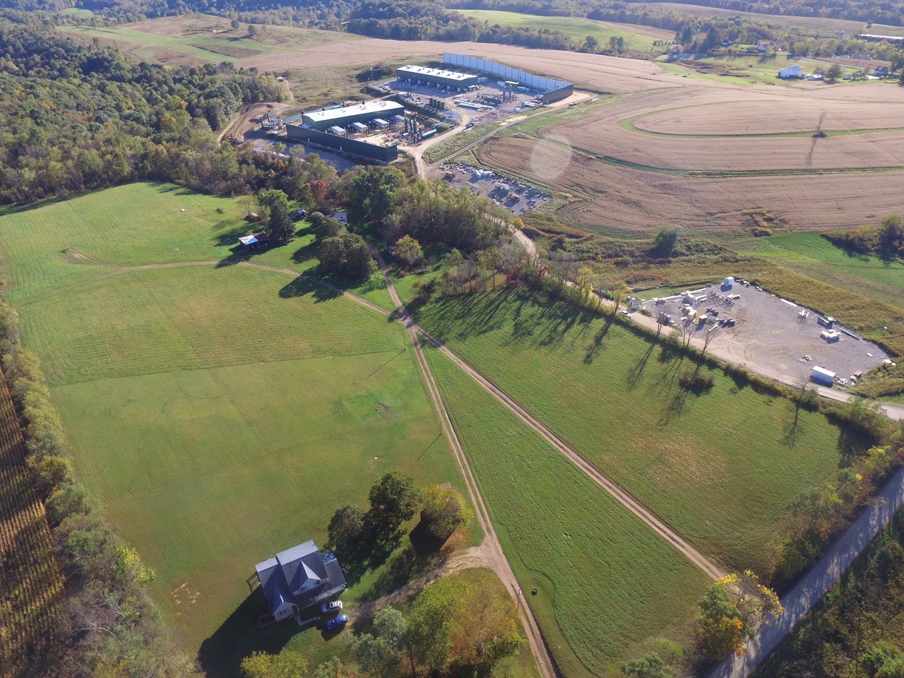
Figure 4. Aerial view of oil and gas infrastructure next to a home in Scenery Hill, PA. Image courtesy of Lois Bower-Bjornson from the Clean Air Council.
Impacts to outdoor recreation activities such as hunting, fishing, and hiking were another recurring theme throughout the interviews. Again, a majority of participants believed their opportunities to partake in outdoor recreation have been limited since fracking operations began in their area.
Among the top concerns was deteriorating air quality and increasing numbers of ozone action days, or days when the air quality index (AQI) for ozone reaches an unhealthy level for sensitive populations. Various participants expressed concerns about letting their children outside due to harmful air emissions and odors originating from well pads or compressor stations. Excessive truck traffic was also a safety concern that was mentioned, especially for those individuals with access roads on or neighboring their property.
Additionally, one individual noted landscape changes in areas commonly used for hiking stating, “You might be hiking along a trail and then realize that you’re no longer on the trail. You’re actually on a pipeline cut. Or you’ll get confused while you’re hiking because you’ll intersect with a road that was developed for a well pad, and it’s not on your map.” Along with hiking, participants also noted a change in hunting and fishing opportunities since fracking moved into the region. Concerns were expressed regarding harvesting any fish or wild game due to possible contamination from fracking chemicals, especially near watersheds with known chemical spills.
Going for a hike and immersing oneself in nature is a healthy way to unwind and relieve stress. However, a rising number of well pads and compressor stations are put in place near parks, hiking trails, and state game lands throughout Southwest Pennsylvania (Figure 5). Participants expressed concerns about feeling unable to escape oil and gas infrastructure, even when visiting these recreational areas. As one individual mentioned, “It really does change your experience of the outdoors. And, you know, it’s an area that’s supposed to be a protected natural area. Then you know you can’t really get away. Even there in public lands far away from buildings and roads. And you can’t really get away from it.”
Figure 5. A map of active oil and gas well pads and compressor stations in Washington County, Pennsylvania. Map layers also indicate wells pads and compressor stations within 1 mile of a park, hiking trail, ball park, or state game land.
But what are the mental health impacts that result from the changing physical landscape brought about by fracking? Aside from the physical health effects caused by fracking activity — such as respiratory illnesses from air pollution or skin irritation from contaminated well water — these landscape changes have taken a toll on participants’ mental health as well.
Many participants described the sentimental value of their property, and the beautiful scenery surrounding their generational family farms. But after fracking began on neighboring property, witnessing their tranquil family farm suddenly become surrounded by dusty access roads, excessive truck traffic, noise, and deteriorating air quality took a serious emotional and mental toll. When asked about the impact of the changing landscape, one participant stated, “It’s the emotional part of watching her childhood farm being destroyed while she is trying to do everything she can to rebuild it to the way it used to be.”
An additional emergent theme surrounding fracking landscape changes was surrounding agricultural impacts. Participants with agricultural land were asked additional questions about fracking’s impacts on their ability to use their farmland. One individual noted that one of their fields was now unusable due to large rocks and filter fabrics left from construction of a well pad, and redirected runoff uphill of their fields. The loss of productive farmland has further contributed to the mental and emotional stress. One participant added, “Our house is ruined, our health is ruined, and our farms are ruined.” In addition to agricultural impacts on large farms, multiple participants also mentioned concerns about their smaller-scale gardens, citing uncertainty about the impacts of air pollution and soil contamination on their produce.
Some participants mentioned feelings of powerlessness against the oil and gas industry. Many families were not consulted prior to fracking operations beginning adjacent to their property. In some cases, this has resulted in significant declines in property values, leaving residents with no financial means to escape oil and gas activity. It is important to note that many residents are given temporary financial incentives to allow fracking on their land. However, to some, the monetary compensation failed to make up for the toll fracking took on their physical and mental health. Lastly, some participants also mentioned feeling stress and anxiety from the social tension resulting from fracking. Debates about the restrictions and regulations on fracking have divided many communities, leading to conflicts and social tensions between once-amiable neighbors.
In addition to the interviews, an online survey was distributed to gain more insight as to where concerns about the changing physical landscape fell in relation to other effects associated with oil and gas development (such as poor air quality, water or soil contamination, truck traffic, and noise).
Nine individuals responded to the survey, all of whom indicated having oil and gas infrastructure within five miles of their home. All respondents also indicated that they participated in a wide variety of outdoor recreation activities such as hiking, wildlife viewing/photography, camping, hunting, and fishing.
Interestedly, only five respondents stated they felt fracking had a negative impact on their health, three responded they were unsure, and one responded no. However, all participants felt fracking had a negative impact on their surrounding environment. When discussing outdoor recreation, eight of nine respondents stated they felt fracking limited their access to outdoor recreation opportunities.
Next, respondents indicated that the level of concern related to the changing landscape brought about by fracking was equal to concerns about air pollution, water and soil contamination, noise, and truck traffic (using a 5-point likert scale). Lastly, one respondent stated that they closed their outdoor recreation tourism business due to blowdown emission (the release of gas from a pipeline to the atmosphere in order to relieve pressure in the pipe so that maintenance or testing can take place) and noise from fracking operations.
In summary, fracking operations have deeply impacted these individuals living in Washington County, Pennsylvania. Not only do residents experience deteriorating air quality, water contamination, and physical health effects, but the mental and emotional toll of witnessing multigenerational farms become forever changed can be overbearing. Other mental health impacts included rising social tensions, feelings of powerlessness, and continuous emotional distress. Fracking operations continue to change the physical landscape, tarnishing Southwest Pennsylvania’s natural beauty and threatening access to outdoor recreation opportunities. Unfortunately, those not living in the direct path of fracking operations struggle to grasp the severity of fracking’s impact on families living with oil and gas infrastructure on or near their property. More widespread awareness of fracking’s impacts is needed to educate communities and call for stricter enforcement of regulations for the oil and gas industry. As one resident summed up their experiences,
“Engines are running full blast, shining lights, and just spewing toxins out there. And you can’t get away from it. You just can’t. You can’t drink the water. You can’t breathe the air. You can’t farm the ground. And you’re stuck here.”
Hopefully, shedding light on residents’ experiences such as these will bring policymakers to reconsider fracking regulations to minimize the impact on public health and the surrounding environment.
By Emma Vieregge, FracTracker Summer 2020 Environmental and Health Fellow
The 2020 Environmental Health Fellowship was made possible by the Community Foundation for the Alleghenies and the Heinz Endowments.
Many thanks to all participants who took the time to share their experiences with me, Lois Bower-Bjornson with the Clean Air Council, Jessa Chabeau at the Southwest Pennsylvania Environmental Health Project, and the FracTracker team for all of their feedback and expertise.
Feature image courtesy of Lois Bower-Bjornson from the Clean Air Council.
1 Beyer, K., Kaltenbach, A., Szabo, A., Bogar, S., Nieto, F., & Malecki, K. (2014). Exposure to Neighborhood Green Space and Mental Health: Evidence from the Survey of the Health of Wisconsin. International Journal of Environmental Research and Public Health, 11(3), 3453-3472. doi:10.3390/ijerph110303453
2 Berman, M. G., Kross, E., Krpan, K. M., Askren, M. K., Burson, A., Deldin, P. J., . . . Jonides, J. (2012). Interacting with nature improves cognition and affect for individuals with depression. Journal of Affective Disorders, 140(3), 300-305. doi:10.1016/j.jad.2012.03.012
3 Maas, J., Dillen, S. M., Verheij, R. A., & Groenewegen, P. P. (2009). Social contacts as a possible mechanism behind the relation between green space and health. Health & Place, 15(2), 586-595. doi:10.1016/j.healthplace.2008.09.006


As a spring 2020 intern with FracTracker, my work mostly involved mapping gathering lines in West Virginia and Ohio. Gathering lines are pipelines that transport oil and gas from the wellhead to either compressor stations or storage/processing facilities. The transmission pipelines (which are often larger in diameter than gathering lines) take the oil and gas from the processing facilities to other storage facilities/compressor stations, or to distribution pipelines which go to end users and consumers. As you can see from Figure 2 in the map of Doddridge County, WV, many gathering lines eventually converge at a compressor station. You can think of gathering lines like small brooks and streams that feed transmission pipelines. The transmission lines are the main arteries, like a river, moving larger quantities of gas and oil over longer distances.
The main project and goal of my internship was to record as many gathering pipelines as I could find in Ohio and West Virginia, since gathering lines are not generally mapped and therefore not easily available for the public to view. For example, the National Pipeline Mapping System’s public map viewer (created by the Department of Transportation Pipeline and Hazardous Materials Safety Administration) has a note stating, “It does not contain gas gathering or distribution pipelines.” Mapping gathering lines makes this data accessible to the public and will allow us to see the bigger picture when it comes to assessing the environmental impact of pipelines.
After collecting gathering line location data, I performed GIS analysis to determine the amount of acreage of land that has been clearcut due to gathering pipeline installations.
Another analysis we could perform using this data is to count the total number of waterways that the gathering lines cross/interact with and assess the quality of water and wildlife in areas with higher concentrations of gathering pipelines.

Figure 1. This map shows an overview of gathering line pipelines in the Powhatan Point, Ohio and Moundsville, West Virginia of the Ohio River Valley.
I worked with an aerial imagery BaseMap layer (a BaseMap is the bottommost layer when viewing a map), a county boundaries layer, production well location points, and compressor station location points. I then traced lines on the earth that appeared to be gathering lines by creating polygon shapefiles in the GIS application ArcMap.
My methodology and process of finding the actual routes of the gathering lines included examining locations at various map scale ranges to find emerging line patterns of barren land that connect different production well points on the map. I would either concentrate on looking for patterns along well pad location points and look for paths that may connect those points, or I would begin at the nearest gathering line I had recorded to try to find off-shoot paths off of those pipelines that may connect to a well pad, compressor station or previously recorded gathering line.
I did run into a few problems during my search for gathering lines. Sometimes, I would begin to trace a gathering line path, only to either loose the path entirely, or on further inspection, find that it was a power line path. Other times when using the aerial imagery basemap, the gathering line would flow into an aerial photo from a year prior to the pipeline installation and I would again lose the path. To work around these issues, I would first follow the gathering line trail to its end point before I started tracing the path. I would also view the path very closely in various scale ranges to ensure I wasn’t tracing a road, waterway, or powerline pathway.
In the three months that I was working on recording gathering pipeline paths in Ohio and West Virginia, I found approximately 29,103 acres (3,494 miles) of barren land clearcut by gathering pipelines. These total amounts are not exact since not all gathering lines can be confirmed. There are still more gathering lines to be recorded in both Ohio and West Virginia, but these figures give the reader an idea of the land disturbance caused by gathering lines, as shown in Figures 1 and 2.
In Ohio, I recorded approximately 10,083 acres (641 miles) with the average individual gathering pipeline taking up about 45 acres of land. With my gathering line data and data previously recorded by FracTracker, I found that there are 28,490 acres (1,690 miles) of land spanning 9 counties in southeastern Ohio that have been cleared and used by gathering lines.
For West Virginia, I was able to record approximately 19,020 acres (1,547 miles) of gathering lines, with the average gathering line taking up about 48 acres of space each. With previous data recorded in West Virginia by FracTracker, the total we have so far for the state is 22,897 acres (1,804 miles), although that is only accounting for the 9 counties in northern West Virginia that are recorded.
Figure 2. This aerial view map shows connecting gathering line pipelines that cover a small portion of Doddridge County, WV.
I was shocked to see how many gathering lines there are in these rural areas. Not only are they very prevalent in these less populated communities, but it was surprising to see how concentrated and close together they tend to be. When most people think of pipelines, they think of the big transmission pipeline paths that cross multiple states and are unaware of how much land that the infrastructure of these gathering pipelines also take up.
It was also very eye-opening to find that there are at least 29,000 acres of land in Ohio and West Virginia that were clearcut for the installation of gathering lines. It is even more shocking that these gathering pipelines are not being recorded or mapped and that this data is not publicly available from the National Pipeline Mapping System. While driving through these areas you may only see one or two pipelines briefly from your car, but by viewing the land from a bird’s eye perspective, you get a sense of the scale of this massive network. While the transmission pipeline arteries tend to be bigger, the veins of gathering lines displace a large amount of land as well.
I was also surprised by the sheer number of gathering lines I found that crossed waterways, rivers, and streams. During this project, it wasn’t unusual at all to follow a gathering line path that would cross water multiple times. In the future, I would be interested to look at the number of times these gathering pipelines cross paths with a stream or river, and the impact that this has on water quality and surrounding environment. I hope to continue to record gathering lines in Ohio and West Virginia, as well as Pennsylvania, so that we may learn more about this infrastructure and the impact it may have on the environment.
I first heard of FracTracker three years ago when I was volunteering with an environmental group called Keep Wayne Wild in Ohio. Since learning about FracTracker, I have been impressed with their eye-opening projects and their ability to make the gas and oil industry more transparent. A few years after first hearing about FracTracker, and as my interest in the GIS field continued to grow, I began taking GIS classes and reached out to them for this internship opportunity.
By Trevor Oatts, FracTracker Spring 2020 Data & GIS Intern
FracTracker’s Great Lakes Program Coordinator Ted Auch explores the risks and damages brought on by fracking in Ohio’s Captina Creek Watershed
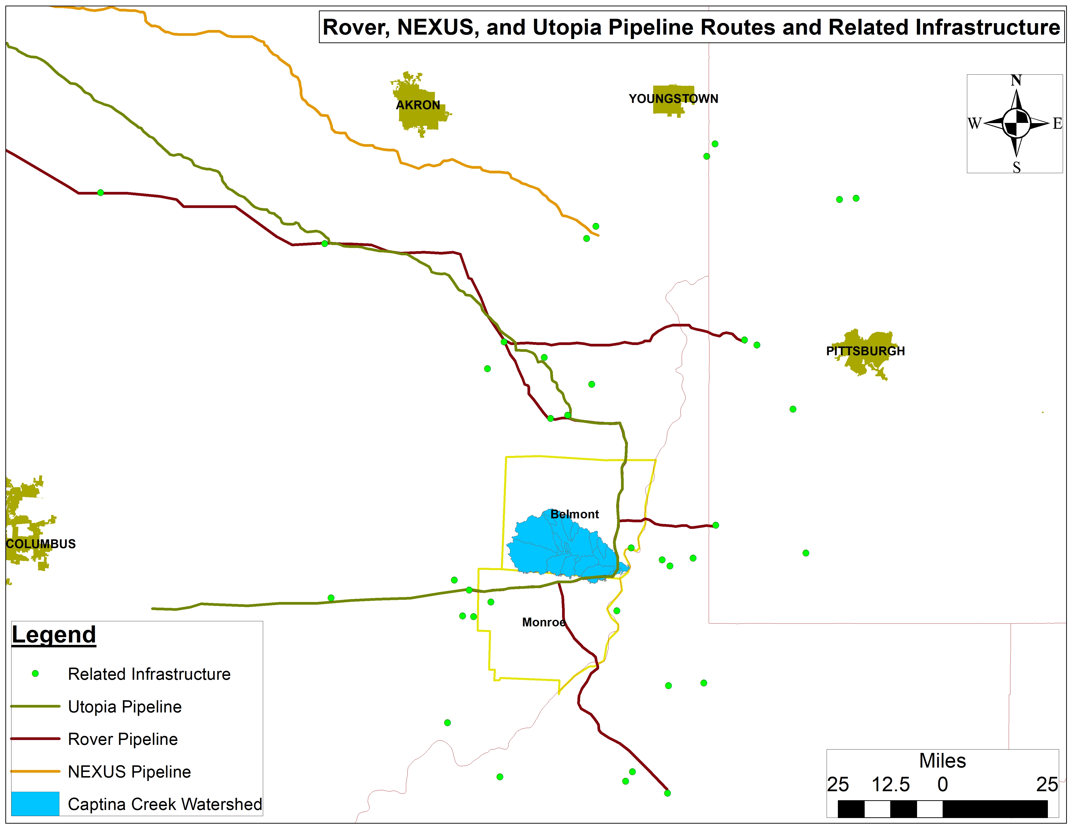
The Captina Creek Watershed straddles the counties of Belmont and Monroe in Southeastern Ohio and feeds into the Ohio River. It is the highest quality watershed in all of Ohio and a great examples of what the Ohio River Valley’s tributaries once looked, smelled, and sounded like. Sadly, today it is caught in the cross-hairs of the oil and gas industry by way of drilling, massive amounts of water demands, pipeline construction, and fracking waste production, transport, and disposal. The images and footage presented in the story map below are testament to the risks and damage inherent to fracking in the Captina Creek watershed and to this industry at large. Data included herein includes gas gathering and interstate transmission pipelines like the Rover, NEXUS, and Utopia (Figure 1), along with Class II wastewater injection wells, compressor stations, unconventional laterals, and freshwater withdrawal sites and volumes.
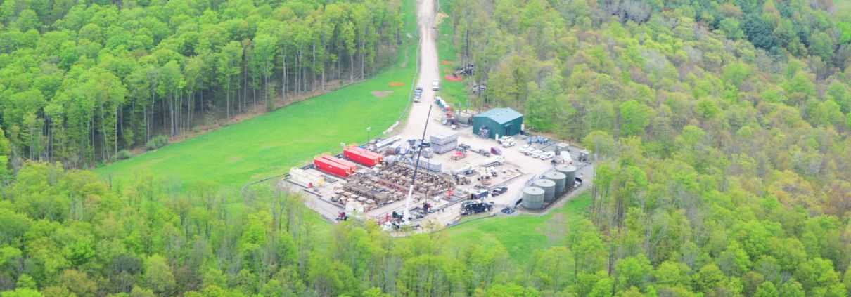
The image at the top of the page captures my motivation for taking a deeper dive into this watershed. Having spent 13+ years living in Vermont and hiking throughout The Green and Adirondack Mountains, I fell in love with the two most prominent tree species in this photo: Yellow Birch (Betula alleghaniensis) and Northern Hemlock (Tsuga candadensis). This feeling of being at home was reason enough to be thankful for Captina Creek in my eyes. Seeing this region under pressure from the oil and gas industry really hit me in my botanical soul. We remain positive with regards to the area’s future, but protective action against fracking in the Captina Creek Watershed is needed immediately!
Guest blog by Christine Yellowthunder, an environmental activist, tree farmer, and poet
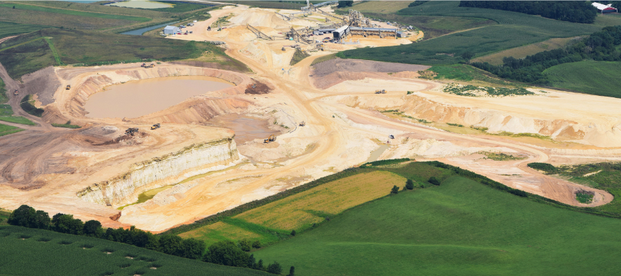
Most people living in Wisconsin, Minnesota and Iowa have increased their knowledge over the past six years regarding the fracking destruction occurring across the country. The horror of fracking damages to life and land remain in the minds of most people who live near the massive land destruction from silica sand mining for what the unconventional oil and gas industry lovingly calls “proppant”.
Very often, we in the Midwest wonder if the rest of the country knows that this specialized form of silica sand mining destroys our rolling hills, woodlands, and water sources in order for silica sand to feed the fracking industry’s insatiable proppant demand.
Those of us who live in the direct path of this unhealthy silica sand mining need to make our stories known.
The quiet abundance of life on an 80-acre tree farm in Wisconsin, fed by natural springs and wetlands, has nurtured every dream this prairie-raised transplant could conceive in the last 30 years. Six years of vigilance and rational debate has led to loss on every front when addressing the local government’s permitting of silica sand mines and its health and safety impacts on the community.
The largest sand mine in Bridge Creek Town lies one mile north of our tree farm. Two years ago, 40 acres of trees were culled for the installation of high intensity power lines to feed anticipated silica sand mine expansion under the legal provision of “Right-of-Way.” That document was signed by a previous land owner in 1948. No specific amount of land was specified on the original right-of-way, thus allowing significant legal destruction and permanent loss against the farm.
However, from a tree farm owner’s perspective, we have seen the variety and number of wildlife species increase at our farm over the past six years – likely because these species view our farm as an oasis, or what ecologists call a refugium, in an otherwise altered mixed-use landscape. The maximum capacity of the tree farm as a wildlife sanctuary is unknown. The adjacent silica Hi-Crush sand mine depletes the hillsides and woodlots in its path.
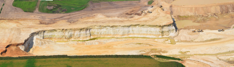
Frac sand mine in Eau Claire County, WI
The weekly blasting away of the hillsides sends shock waves – shaking homes and outbuildings weekly, along with our nerves. Visible cracks appear in the walls of buildings, and private wells are monitored for collapse and contamination. The sand mine only guarantees repair to property lying within a half-mile of the mine. The mine blasts the land near Amish schools and has had a noticeable effect on the psyche of countless farm animals. The invisible silica is breathed by every living thing much to the mine’s denial, with deadly silicosis appearing up to 15 years after initial exposure. Our community is left to wonder who will manifest the health effects first. Blasting unearths arsenic, lead, and other contaminants into private wells and into the remaining soil.
There has been no successful reclamation of the land after it is mined, with most residents wondering what the actual point is of developing a reclamation plan is if timely implementation and stringent reclamation metrics are not enforced. All useful topsoil has been stripped away and is dead with the land only able to support sedge grasses and very few of them at best. No farming on this mined land can occur even though these mining companies promise farm owners that when they are done mining, soil productivity will meet or exceed pre-mining conditions and much milder slopes than the pre-mining bluffs that contained the silica sand. Needless to say, land values of homes, farms, and property decrease as the mines creeps closer.
Explore photos of Hi-Crush Partner’s frac sand mine:


Bridge Creek, as well as many other towns, have been easy picking for the mines. Many towns are unzoned, having little industry, a meager tax base, and a huge land area for a very sparse population. The unemployment and underemployment rates are quite high. Many residents in Bridge Creek farm, including a very large population of Amish who own a checkerboard of land used for farming and saw mills. Most of these Amish families arrived here from Canada and bought farms when the mid 80’s drought put small farms up for sale. The Amish community seldom votes, and their strong religious beliefs prevent them from taking a stand on any political issues.
Video of contaminated well water an Amish farm in Augusta, WI near frac sand mining
Scroll to the end of the article to explore more impacts to the Amish community
The original residents of this land, the Ho-Chunk people, are few in number and wish to protect their home lands that they had purchased back from the government.
Furthermore, a significant number of artists live in this community and have chosen to keep their homes and studios in anonymity. Thus, it is very difficult to amass any unity among this diverse population to stand up to the local government. Many long-time residents have the attitude that you can’t stop “progress.” I wonder if they know that this kind of progress kills the future?
Broken promises made by the mining company for jobs and huge payments to the initial land sellers have divided families and the community. Even though the mining boom was sold as a job provider, few locals are employed by the mines. There is little faith that the local government will provide for the safety and well being of its residents. Presentation of research, facts regarding aquifer endangerment and silica sand health risks, and proposals written in detail outlining potential protective ordinances have cost citizens, including myself, enormous amounts of time and money. The government responses remain the same. The sand mines have been allowed to continue destruction of the natural resources to no one’s benefit except for the enormous profits lining the coffers of the mining corporations.

Today, after six years of continuous silica sand mining moving ever closer, I can no longer fight logically and linearly to eliminate the greed, injustice, and usurped power head on. I fight land destruction as a different warrior.
I choose to protect this land and wood by nurturing its existence through planting more native trees, educating others to the wisdom and wonder of nature, by photo journaling the struggle for its survival and documenting this land’s story so that future citizens will know the truth. Moreover, I will continue to spread the message loud and long: stopping the silica sand mining will stop fracking.
These efforts may be the best that I can manage with a grieving heart. A fierce spirit will continue to share this story and those of others living in the Midwest where the silica sand laden hills roll under the top soil of our lives.
Christine Yellowthunder is an environmental activist of Lakota heritage and is also a tree farmer and poet. She lives on her farm with her husband Ralph Yellowthunder, a Ho-Chunk elder and Vietnam combat veteran.
Listen below to in interview of an Amish farmer and clock maker who lives adjacent to the Hi-Crush mine, by Ted Auch, FracTracker’s Great Lakes Program Coordinator, and local resident, Mary Ann O’Donahue:
The frac sand mine and its impact on well water
1:35 “We had no problem with the well until they started back here, and then from there on she was orange….in June, I put chickens in the barn and I put a new filter in the line…and in a month’s time it was stopped up”
4: 28 “They hauled all that toxic waste to the back of the mine and dumped it”
Water testing and dust in the air
1:35 “They test for magnesium and manganese and aluminum, metals…there’s like 5 pages of them, and iron, mercury, iodine…everything they say if it’s a certain color it’s high…It’s been going up ever since they started. The first test looked real good, before they started doing anything…and every year since, it’s getting higher and higher and higher…I don’t hear nothing from them, they take the sample and that’s it…They don’t come talk about it, they’re not concerned that it’s raising”
7:15 “I can have my cart sitting underneath the overhang by the shop and I’ve never had to worry about it being much dusty. But if it’s sitting underneath there over there in the summer time…it’s not there a day before it’s covered in it.” “And that stuff’s going in your mouth too.”
Hi-Crush pond and blasts from the mine
1:40 “Who knows what’s in the pond?” “Well, that’s the problem, all the chemicals they use they never tell anybody what they’re using to process this stuff, and it’s all in where ever it runs off”
7:15 “You should’ve been here Monday…It was a real hard blast… I had the engine running and was working in [the shop], and it was a very big shaking there, and I noticed it so it had to be a real big one and I came to the door to look and [the smoke from the blast] was still three lengths higher than the tree over there… Usually they’re doing it two times a week…I’m sure it [affected] my house, because my ceiling’s cracked more and more. There was one lady here once when it happened and she didn’t stay very long, she said ‘I’m going home, I’m not staying in this house'”
Impact to animals, light pollution, interactions with workers
0:50 “She was riding a buggy and…they just happened to blast about the time the horse was as close as it could be and the horse freaked out and ran and she couldn’t control it”
Relations between workers, local officials, and the Amish community
Accidents involving farm animals, workers, and residents
Photos of the property and workshop:
Feature image: Frac sand mining in Wisconsin. Photo by Ted Auch, FracTracker Alliance, with aerial assistance from LightHawk.
![]()
216 Franklin St, Suite 400, Johnstown, PA 15901
Phone: +1 (717) 303-0403 | info@fractracker.org
FracTracker Alliance is a 501(c)3 non-profit: Tax identification number: 80-0844297
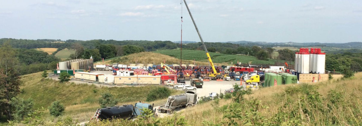 Image courtesy of Lois Bower-Bjornson from the Clean Air Council.
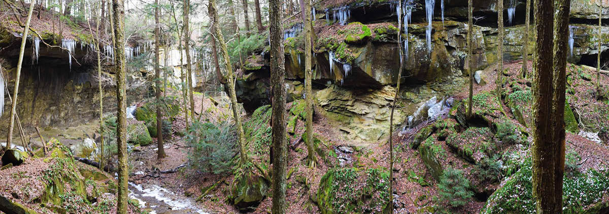 Photo by Ted Auch, FracTracker Alliance


