 https://www.fractracker.org/a5ej20sjfwe/wp-content/uploads/2021/07/California-oil-fields-feature.jpg
667
1500
Kyle Ferrar, MPH
https://www.fractracker.org/a5ej20sjfwe/wp-content/uploads/2025/09/2025-Wordmark-Logo.png
Kyle Ferrar, MPH2025-08-26 17:36:222025-08-27 21:56:28California’s New Oil Wells Average 13.5 Barrels/Day — Far Below State Projections
https://www.fractracker.org/a5ej20sjfwe/wp-content/uploads/2021/07/California-oil-fields-feature.jpg
667
1500
Kyle Ferrar, MPH
https://www.fractracker.org/a5ej20sjfwe/wp-content/uploads/2025/09/2025-Wordmark-Logo.png
Kyle Ferrar, MPH2025-08-26 17:36:222025-08-27 21:56:28California’s New Oil Wells Average 13.5 Barrels/Day — Far Below State ProjectionsIt’s Time to Stop Urban Oil Drilling in Los Angeles
Overview
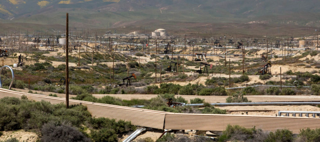
This report finds that disparate counts of drill sites in Los Angeles County, California, are located in marginalized communities. Additionally, a story map of infrared camera footage shows emissions otherwise invisible to the naked eye in Los Angeles urban drilling sites.
When people think of Southern California, images of palm trees, beaches, boardwalks, and nightlife come to mind. Unless you are an Angeleno, you may not associate oil drilling and petroleum extraction with the Golden State.
In truth, Los Angeles is ground zero for urban drilling.
Oil companies drill wells and use toxic industrial chemicals on well sites just feet away from homes, schools, and medical facilities. These urban drilling sites degrade air quality and expose communities to toxic and carcinogenic emissions. Using state-of-the-art optical gas imaging (OGI) cameras, FracTracker Alliance—in collaboration with Earthworks’ Community Empowerment Project—has filmed emissions from oil wells in Los Angeles. The overwhelming amount of existing public health research (including recently published epidemiological reports from Stanford University and The University of California – Berkeley linking adverse birth outcomes [Tran, et al. 2020, Gonzalez, et al. 2020] and University of Southern California/Occidental College report on lung function), has confirmed these emissions are the source of a wide variety of health impacts for Frontline communities.
Previous FracTracker Alliance reports show that Frontline communities in the most heavily drilled areas of Southern California, and specifically those in Los Angeles, are predominantly low-income, non-white, and/or Latino. While city blocks have replaced an amazing number of oil and gas wells, a substantial number of extractive sites persist in these marginalized areas. FracTracker has worked to publish this data to support Frontline communities’ organizing in Los Angeles who have made major accomplishments so far this year.
New policy proposals could shift Southern California from a major source of greenhouse gases into a leader in our fossil-free future. The City of Los Angeles is currently considering zoning regulations to phase out oil drilling in response to a five-year grassroots campaign led by directly affected residents and advocates. The City Council also called on the California Department of Geological Energy Management (CalGEM) to expedite the closure of the Aliso Canyon gas storage facility in Porter Ranch, following its massive blowout in 2015. Additionally, Culver City passed a motion to phase out oil drilling in the Inglewood Field and to clean up wells in surrounding areas within five years!
Now, the Los Angeles County board of supervisors will vote on September 15th to phase out extraction in the unincorporated areas of the county.
Take action here to call on Los Angeles County officials to follow the leadership of local municipalities and phase out oil wells in the unincorporated regions.
While certain cities in Los Angeles have taken steps to reduce extraction, the County of Los Angeles also has the opportunity to address much of the drilling in the basin. The County manages about 1,700 wells located on unincorporated lands. A map of well locations by County Supervisorial Districts can be found below. Population counts were calculated for each district and demographic profiles of the most impacted communities were assessed. The methods used in this analysis can be found in Appendix A, at the end of this article.
Los Angeles County Oil and Gas Wells
This interactive map illustrates the locations of oil and gas wells in Los Angeles County. The map includes boundaries of incorporated city areas overlaid with operational oil and gas wells. Users can toggle different layers in the map on and off to show the status of oil and gas wells, or the location of operational wells in incorporated vs unincorporated areas. View the map “Details” tab below in the top right corner to learn more and access the data, or click on the map to explore the dynamic version of this data. Data sources are also listed at the end of this article. In order to turn layers on and off in the map, use the Layers dropdown menu.
View Full Size Map | Updated 9/13/21| Map Tutorial
The analysis shows that for the majority of Los Angeles County districts, a disproportionate number of drill sites are located in marginalized communities.
The demographics of Angelenos living near operational oil and gas well are more Latinx and non-white than the rest of the county. The most substantial disparities are located in Districts 1, 2, 4, and 5, where the majority of operational wells are also located. In District 2, the unincorporated communities bearing the brunt of exposure from oil are over 65% non-white, and nearly 50% Latino. The most impacted communities in District 4 are over 55% non-white, and over 55% Latino. Least impacted by this trend is District 3, which has the lowest population density and one of the lowest counts of operational oil and gas wells. Notably, operational well numbers in District 1 are lowest because the majority of the district is incorporated city lands. Regardless, the most impacted communities in District 1 are nearly 60% non-white, as well as 55% Latino.

Table 1. Well Counts of urban drilling in unincorporated areas of Los Angeles County Districts 1-5.
Filming Toxic Emissions at Oil Wells in Los Angeles
In the fall of 2019, FracTracker collaborated with Earthworks to visit urban drilling sites in Los Angeles, at the request of Frontline communities.
Fugitive and uncontrolled volatile organic compound (VOC) emissions were filmed by a certified thermographer with a Forward Looking Infrared (FLIR) GF320 camera that uses optical gas imaging (OGI) technology. OGI technology allows the camera to film and record visualizations of VOC emissions based on the absorption of infrared light. It is the exact same technology required by the U.S. EPA under the rule for new source performance standards, and by the California Air Resources Board for Leak Detection and Repair (LDAR) to properly inspect oil and gas infrastructure. The video is in greyscale, and can appear grainy when the camera is being operated in high sensitivity modes, which is sometimes necessary to visualize certain pollution releases. The footage clearly shows the presence of a range of VOCs, methane, and other gases that are otherwise invisible to the naked eye.
The descriptions preceding each video explain what the trained camera operator saw and documented. Emissions sources included a variety of equipment and infrastructure on the wellpads, including the oil wells themselves. The emissions at these sites are typical of oil and gas wells throughout California and Los Angeles. These 17 sites visited over just a few days represent a very small sample of the tens of thousands of well sites in Los Angeles.
View Full Size Map | Updated 6/8/21| Map Tutorial
The analysis shows that for the majority of Los Angeles County districts, a disproportionate number of drill sites are located in marginalized communities.
The demographics of Angelenos living near operational oil and gas well are more Latinx and non-white than the rest of the county. The most substantial disparities are located in Districts 1, 2, 4, and 5, where the majority of operational wells are also located. In District 2, the unincorporated communities bearing the brunt of exposure from oil are over 65% non-white, and nearly 50% Latino. The most impacted communities in District 4 are over 55% non-white, and over 55% Latino. Least impacted by this trend is District 3, which has the lowest population density and one of the lowest counts of operational oil and gas wells. Notably, operational well numbers in District 1 are lowest because the majority of the district is incorporated city lands. Regardless, the most impacted communities in District 1 are nearly 60% non-white, as well as 55% Latino.
Table 1. Well Counts of urban drilling in unincorporated areas of Los Angeles County Districts 1-5.
Filming Toxic Emissions at Oil Wells in Los Angeles
In the fall of 2019, FracTracker collaborated with Earthworks to visit urban drilling sites in Los Angeles, at the request of Frontline communities.
Fugitive and uncontrolled volatile organic compound (VOC) emissions were filmed by a certified thermographer with a Forward Looking Infrared (FLIR) GF320 camera that uses optical gas imaging (OGI) technology. OGI technology allows the camera to film and record visualizations of VOC emissions based on the absorption of infrared light. It is the exact same technology required by the U.S. EPA under the rule for new source performance standards, and by the California Air Resources Board for Leak Detection and Repair (LDAR) to properly inspect oil and gas infrastructure. The video is in greyscale, and can appear grainy when the camera is being operated in high sensitivity modes, which is sometimes necessary to visualize certain pollution releases. The footage clearly shows the presence of a range of VOCs, methane, and other gases that are otherwise invisible to the naked eye.
The descriptions preceding each video explain what the trained camera operator saw and documented. Emissions sources included a variety of equipment and infrastructure on the wellpads, including the oil wells themselves. The emissions at these sites are typical of oil and gas wells throughout California and Los Angeles. These 17 sites visited over just a few days represent a very small sample of the tens of thousands of well sites in Los Angeles.
The Take Away
While the state and Newsom’s Administration delays on instituting any public health measures that would give relief to the largely marginalized communities most impacted by California’s extractive industry, Los Angeles is ready to lead.
Los Angeles County and the cities of Los Angeles and Culver City are moving forward with measures that will greatly benefit the health of Angelenos. With this momentum, now is the time to urge other cities that make up the greater Los Angeles basin to move forward in solidarity to protect the health of Southern California’s Frontline communities.
For more information on how you can make your voice heard, visit the Los Angeles chapter of Physicians for Social Responsibility’s (PSR-LA) website where you can sign up for their newsletter to stay informed about local actions!
References & Where to Learn More
Feature photo from Natural Resources Defense Council
Appendix A
Methods
In this article, we conducted spatial analyses using the demographic data of Frontline communities and the locations of oil and gas wells in Southern California. This assessment used CalGEM data (updated 3/1/21) to map the locations of operational oil and gas wells and permits, as shown above in Figures one through five. GIS analyses were completed using ESRI ArcGIs Pro Ver. 2.6.1, with data projected in NAD83 California Teale Albers, and were limited to the unincorporated areas of Los Angeles County districts. Unincorporated areas were determined using datasets of county districts from L.A. County Enterprise GIS Hub and state datasets of city boundaries from California geoportal.
Block group level “census designated areas” from American Community Survey (2013-2018) demographics were used to estimate counts of Californians living near oil and gas extraction activity. Census block groups were clipped using the buffered datasets of operational oil and gas wells. A uniform population distribution within the census blocks was assumed in order to determine population counts. Census demographics and total population counts were scaled using the proportion of the clipped block groups within the setback area (Areal percentage = Area of block group within established exposure distances of an operational well / Total area of block group).
This conservative approach provided a general overview of the count and demographics of Californians living near extraction operations, but the results do little to shed light on the most impacted Frontline communities, specifically, urban areas with dense populations near large oil fields. More granular analyses at the local level have been conducted by FracTracker Alliance recently, and can be found in the People and Production report on the FracTracker Alliance website.
Datasets utilized:
- CalGEM AllWells.csv dataset. https://www.conservation.ca.gov/calgem/Online_Data. Downloaded 7/3/21.
- California Counties and City Boundaries. California Department of Tax and Fee Administration. https://gis.data.ca.gov/datasets/CDTFA::city-and-county-boundaries/about. Downloaded 7/15/21.
- Los Angeles County Supervisorial Districts. County of LA. https://geohub.lacity.org/datasets/lacounty::supervisorial-districts-2011/about. Downloaded 6/12/21
Topics in This Article:
Join the Conversation
Stay Informed
Support Our Work
FracTracker Alliance helps communicate the risks of oil and gas and petrochemical development to advance just energy alternatives that protect public health, natural resources, and the climate.
By contributing to FracTracker, you are helping to make tangible changes, such as decreasing the number of oil and gas wells in the US, protecting the public from toxic and radioactive chemicals, and stopping petrochemical expansion into vulnerable communities.
Your donations help fund the sourcing and analysis of new data so that we can keep you informed and continually update our resources.
Please donate to FracTracker today as a way to advocate for clean water, clean air, and healthy communities.
What You Should Read Next
https://www.fractracker.org/a5ej20sjfwe/wp-content/uploads/2021/07/California-oil-fields-feature.jpg
667
1500
Kyle Ferrar, MPH
https://www.fractracker.org/a5ej20sjfwe/wp-content/uploads/2025/09/2025-Wordmark-Logo.png
Kyle Ferrar, MPH2025-08-26 17:36:222025-08-27 21:56:28California’s New Oil Wells Average 13.5 Barrels/Day — Far Below State Projections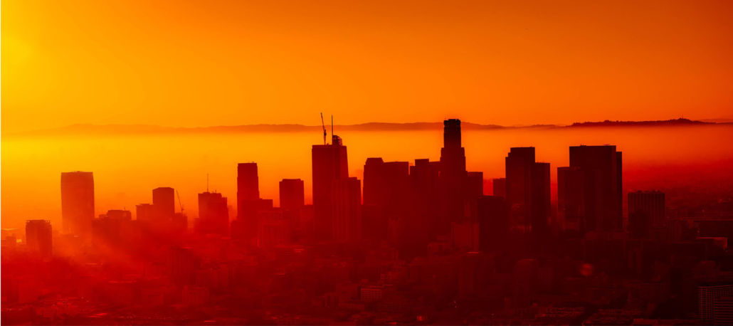 https://www.fractracker.org/a5ej20sjfwe/wp-content/uploads/2021/02/Los-Angeles-skyline-feature-scaled.jpg
667
1500
Kyle Ferrar, MPH
https://www.fractracker.org/a5ej20sjfwe/wp-content/uploads/2025/09/2025-Wordmark-Logo.png
Kyle Ferrar, MPH2025-03-27 15:37:102025-04-01 12:55:42Environmental Justice Analysis of Oil Extraction in Los Angeles Communities
https://www.fractracker.org/a5ej20sjfwe/wp-content/uploads/2021/02/Los-Angeles-skyline-feature-scaled.jpg
667
1500
Kyle Ferrar, MPH
https://www.fractracker.org/a5ej20sjfwe/wp-content/uploads/2025/09/2025-Wordmark-Logo.png
Kyle Ferrar, MPH2025-03-27 15:37:102025-04-01 12:55:42Environmental Justice Analysis of Oil Extraction in Los Angeles Communities https://www.fractracker.org/a5ej20sjfwe/wp-content/uploads/2025/02/1400669_062416-kabc-cuffe-erskine1-imgcrtr.jpg
720
1280
FracTracker Alliance
https://www.fractracker.org/a5ej20sjfwe/wp-content/uploads/2025/09/2025-Wordmark-Logo.png
FracTracker Alliance2025-01-31 12:07:132025-02-06 14:11:38Can California Energy Policy Move Past its Contradictions?
https://www.fractracker.org/a5ej20sjfwe/wp-content/uploads/2025/02/1400669_062416-kabc-cuffe-erskine1-imgcrtr.jpg
720
1280
FracTracker Alliance
https://www.fractracker.org/a5ej20sjfwe/wp-content/uploads/2025/09/2025-Wordmark-Logo.png
FracTracker Alliance2025-01-31 12:07:132025-02-06 14:11:38Can California Energy Policy Move Past its Contradictions? https://www.fractracker.org/a5ej20sjfwe/wp-content/uploads/2019/03/IdleWellsHathaway_resize.jpg
400
900
Kyle Ferrar, MPH
https://www.fractracker.org/a5ej20sjfwe/wp-content/uploads/2025/09/2025-Wordmark-Logo.png
Kyle Ferrar, MPH2024-05-02 10:32:552024-05-02 12:43:28California Must Improve Management of Idle Wells
https://www.fractracker.org/a5ej20sjfwe/wp-content/uploads/2019/03/IdleWellsHathaway_resize.jpg
400
900
Kyle Ferrar, MPH
https://www.fractracker.org/a5ej20sjfwe/wp-content/uploads/2025/09/2025-Wordmark-Logo.png
Kyle Ferrar, MPH2024-05-02 10:32:552024-05-02 12:43:28California Must Improve Management of Idle Wells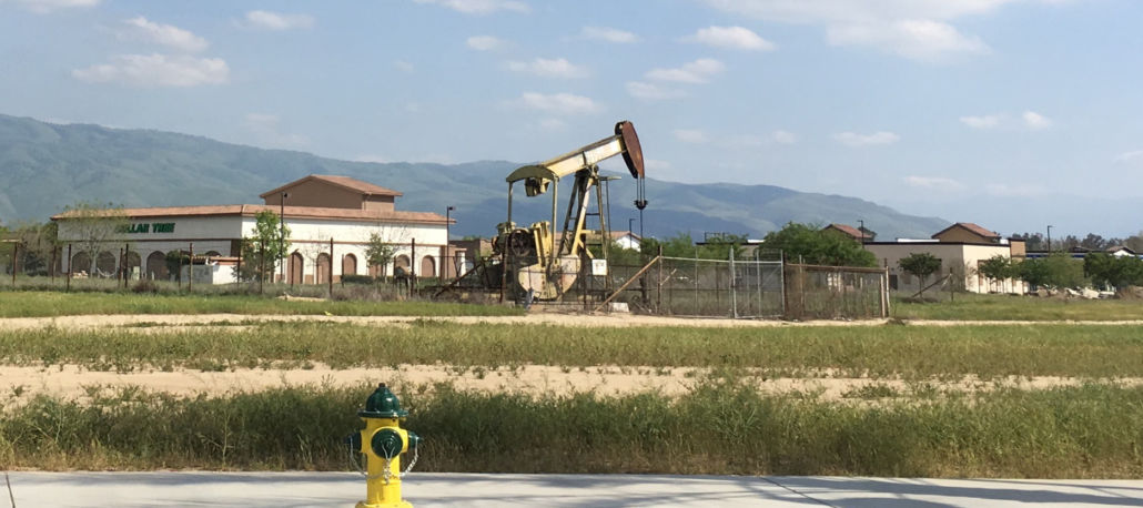 https://www.fractracker.org/a5ej20sjfwe/wp-content/uploads/2020/04/California-well-pad.jpg
666
1500
FracTracker Alliance
https://www.fractracker.org/a5ej20sjfwe/wp-content/uploads/2025/09/2025-Wordmark-Logo.png
FracTracker Alliance2024-03-07 17:01:582024-03-12 09:55:39Chevron’s $2.3 Billion Asset Adjustment Raises Questions Amidst Regulatory Changes in California
https://www.fractracker.org/a5ej20sjfwe/wp-content/uploads/2020/04/California-well-pad.jpg
666
1500
FracTracker Alliance
https://www.fractracker.org/a5ej20sjfwe/wp-content/uploads/2025/09/2025-Wordmark-Logo.png
FracTracker Alliance2024-03-07 17:01:582024-03-12 09:55:39Chevron’s $2.3 Billion Asset Adjustment Raises Questions Amidst Regulatory Changes in California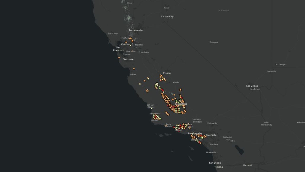 FracTracker Alliance, 2024
https://www.fractracker.org/a5ej20sjfwe/wp-content/uploads/2024/01/California-Daily-Oil-Production-2024.jpg
844
1500
Kyle Ferrar, MPH
https://www.fractracker.org/a5ej20sjfwe/wp-content/uploads/2025/09/2025-Wordmark-Logo.png
Kyle Ferrar, MPH2024-01-30 05:00:012024-02-05 13:46:42Index of Oil and Gas Operator Health in California Shows Risks to State Economy and Taxpayers
FracTracker Alliance, 2024
https://www.fractracker.org/a5ej20sjfwe/wp-content/uploads/2024/01/California-Daily-Oil-Production-2024.jpg
844
1500
Kyle Ferrar, MPH
https://www.fractracker.org/a5ej20sjfwe/wp-content/uploads/2025/09/2025-Wordmark-Logo.png
Kyle Ferrar, MPH2024-01-30 05:00:012024-02-05 13:46:42Index of Oil and Gas Operator Health in California Shows Risks to State Economy and Taxpayers https://www.fractracker.org/a5ej20sjfwe/wp-content/uploads/2023/10/Wells-Within-3200-Feet-of-Schools-Childcare-CA.jpg
595
1500
Kyle Ferrar, MPH
https://www.fractracker.org/a5ej20sjfwe/wp-content/uploads/2025/09/2025-Wordmark-Logo.png
Kyle Ferrar, MPH2023-10-04 16:38:472023-10-04 21:19:54Oil and Gas Activity Within California Public Health Protection Zones
https://www.fractracker.org/a5ej20sjfwe/wp-content/uploads/2023/10/Wells-Within-3200-Feet-of-Schools-Childcare-CA.jpg
595
1500
Kyle Ferrar, MPH
https://www.fractracker.org/a5ej20sjfwe/wp-content/uploads/2025/09/2025-Wordmark-Logo.png
Kyle Ferrar, MPH2023-10-04 16:38:472023-10-04 21:19:54Oil and Gas Activity Within California Public Health Protection Zones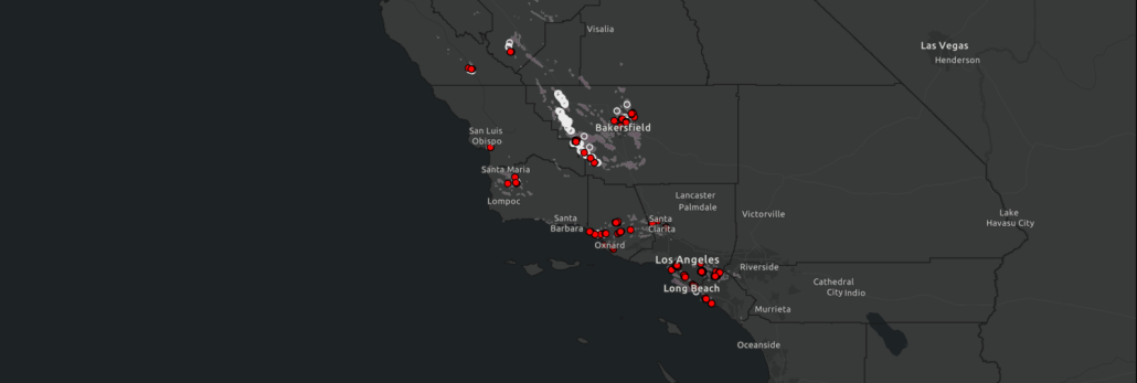 https://www.fractracker.org/a5ej20sjfwe/wp-content/uploads/2023/04/Rework-Permits-Feature-Image.png
506
1500
Kyle Ferrar, MPH
https://www.fractracker.org/a5ej20sjfwe/wp-content/uploads/2025/09/2025-Wordmark-Logo.png
Kyle Ferrar, MPH2023-04-14 11:36:392023-04-28 16:05:23CalGEM Permit Review Q1 2023: Well Rework Permits Increase by 76% in California
https://www.fractracker.org/a5ej20sjfwe/wp-content/uploads/2023/04/Rework-Permits-Feature-Image.png
506
1500
Kyle Ferrar, MPH
https://www.fractracker.org/a5ej20sjfwe/wp-content/uploads/2025/09/2025-Wordmark-Logo.png
Kyle Ferrar, MPH2023-04-14 11:36:392023-04-28 16:05:23CalGEM Permit Review Q1 2023: Well Rework Permits Increase by 76% in California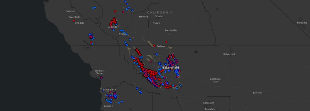 https://www.fractracker.org/a5ej20sjfwe/wp-content/uploads/2023/01/California-Rework-Permits-2023.jpg
541
1500
Kyle Ferrar, MPH
https://www.fractracker.org/a5ej20sjfwe/wp-content/uploads/2025/09/2025-Wordmark-Logo.png
Kyle Ferrar, MPH2023-01-24 09:01:352023-01-24 13:21:55Assessment of Rework Permits on Oil Production from Operational Wells Within the 3,200-Foot Public Health Protection Zone
https://www.fractracker.org/a5ej20sjfwe/wp-content/uploads/2023/01/California-Rework-Permits-2023.jpg
541
1500
Kyle Ferrar, MPH
https://www.fractracker.org/a5ej20sjfwe/wp-content/uploads/2025/09/2025-Wordmark-Logo.png
Kyle Ferrar, MPH2023-01-24 09:01:352023-01-24 13:21:55Assessment of Rework Permits on Oil Production from Operational Wells Within the 3,200-Foot Public Health Protection Zone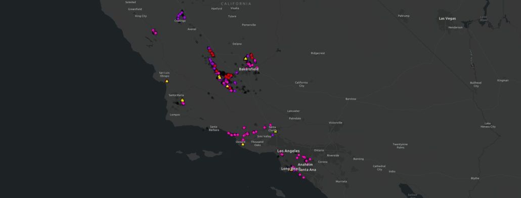 https://www.fractracker.org/a5ej20sjfwe/wp-content/uploads/2023/01/CalGEM-Q4-2022-Permit-Review.jpg
570
1500
Kyle Ferrar, MPH
https://www.fractracker.org/a5ej20sjfwe/wp-content/uploads/2025/09/2025-Wordmark-Logo.png
Kyle Ferrar, MPH2023-01-18 18:01:532023-01-18 18:03:23CalGEM Permit Review Q4 2022: Oil Permit Approvals Show Steep Rise Within Protective Buffer Zones
https://www.fractracker.org/a5ej20sjfwe/wp-content/uploads/2023/01/CalGEM-Q4-2022-Permit-Review.jpg
570
1500
Kyle Ferrar, MPH
https://www.fractracker.org/a5ej20sjfwe/wp-content/uploads/2025/09/2025-Wordmark-Logo.png
Kyle Ferrar, MPH2023-01-18 18:01:532023-01-18 18:03:23CalGEM Permit Review Q4 2022: Oil Permit Approvals Show Steep Rise Within Protective Buffer Zones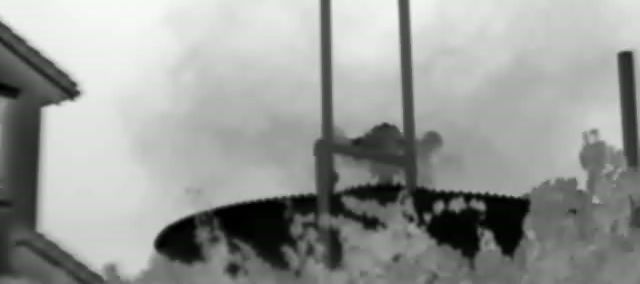 https://www.fractracker.org/a5ej20sjfwe/wp-content/uploads/2022/08/MOV_8837_Moment-e1663254387862.jpg
284
640
Kyle Ferrar, MPH
https://www.fractracker.org/a5ej20sjfwe/wp-content/uploads/2025/09/2025-Wordmark-Logo.png
Kyle Ferrar, MPH2022-08-22 09:52:582026-04-28 14:45:28FracTracker Finds Widespread Hydrocarbon Emissions from Active & Idle Oil and Gas Wells and Infrastructure in California
https://www.fractracker.org/a5ej20sjfwe/wp-content/uploads/2022/08/MOV_8837_Moment-e1663254387862.jpg
284
640
Kyle Ferrar, MPH
https://www.fractracker.org/a5ej20sjfwe/wp-content/uploads/2025/09/2025-Wordmark-Logo.png
Kyle Ferrar, MPH2022-08-22 09:52:582026-04-28 14:45:28FracTracker Finds Widespread Hydrocarbon Emissions from Active & Idle Oil and Gas Wells and Infrastructure in California https://www.fractracker.org/a5ej20sjfwe/wp-content/uploads/2022/07/kyle-ferrar-e1663254307641.jpg
636
1430
Kyle Ferrar, MPH
https://www.fractracker.org/a5ej20sjfwe/wp-content/uploads/2025/09/2025-Wordmark-Logo.png
Kyle Ferrar, MPH2022-07-29 19:04:322022-09-15 11:05:17California Regulators Approve More Oil Well Permits Amid a Crisis of Leaking Oil Wells that Should be Plugged
https://www.fractracker.org/a5ej20sjfwe/wp-content/uploads/2022/07/kyle-ferrar-e1663254307641.jpg
636
1430
Kyle Ferrar, MPH
https://www.fractracker.org/a5ej20sjfwe/wp-content/uploads/2025/09/2025-Wordmark-Logo.png
Kyle Ferrar, MPH2022-07-29 19:04:322022-09-15 11:05:17California Regulators Approve More Oil Well Permits Amid a Crisis of Leaking Oil Wells that Should be Plugged https://www.fractracker.org/a5ej20sjfwe/wp-content/uploads/2022/03/KFerrar-feature-CAsetbacks2022.jpg
878
1500
Kyle Ferrar, MPH
https://www.fractracker.org/a5ej20sjfwe/wp-content/uploads/2025/09/2025-Wordmark-Logo.png
Kyle Ferrar, MPH2022-04-06 12:01:332023-08-24 19:08:53Implications of a 3,200-foot Setback in California
https://www.fractracker.org/a5ej20sjfwe/wp-content/uploads/2022/03/KFerrar-feature-CAsetbacks2022.jpg
878
1500
Kyle Ferrar, MPH
https://www.fractracker.org/a5ej20sjfwe/wp-content/uploads/2025/09/2025-Wordmark-Logo.png
Kyle Ferrar, MPH2022-04-06 12:01:332023-08-24 19:08:53Implications of a 3,200-foot Setback in California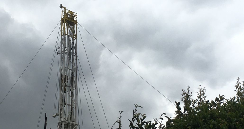 https://www.fractracker.org/a5ej20sjfwe/wp-content/uploads/2022/03/BLenker_infrastructure-oilrig-southLA-CA_Oct20173.jpg
795
1500
Kyle Ferrar, MPH
https://www.fractracker.org/a5ej20sjfwe/wp-content/uploads/2025/09/2025-Wordmark-Logo.png
Kyle Ferrar, MPH2022-03-15 16:32:032022-03-15 18:00:00New Trends in Drilling Permit Approvals Take Shape in CA
https://www.fractracker.org/a5ej20sjfwe/wp-content/uploads/2022/03/BLenker_infrastructure-oilrig-southLA-CA_Oct20173.jpg
795
1500
Kyle Ferrar, MPH
https://www.fractracker.org/a5ej20sjfwe/wp-content/uploads/2025/09/2025-Wordmark-Logo.png
Kyle Ferrar, MPH2022-03-15 16:32:032022-03-15 18:00:00New Trends in Drilling Permit Approvals Take Shape in CA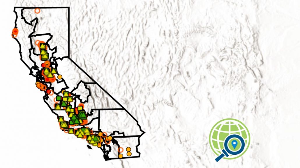 https://www.fractracker.org/a5ej20sjfwe/wp-content/uploads/2022/03/KFerrar-CAlegislative-analysis_March2022.jpg
720
1280
Kyle Ferrar, MPH
https://www.fractracker.org/a5ej20sjfwe/wp-content/uploads/2025/09/2025-Wordmark-Logo.png
Kyle Ferrar, MPH2022-03-14 15:18:402022-03-14 15:18:40Oil and Gas Drilling in California Legislative Districts
https://www.fractracker.org/a5ej20sjfwe/wp-content/uploads/2022/03/KFerrar-CAlegislative-analysis_March2022.jpg
720
1280
Kyle Ferrar, MPH
https://www.fractracker.org/a5ej20sjfwe/wp-content/uploads/2025/09/2025-Wordmark-Logo.png
Kyle Ferrar, MPH2022-03-14 15:18:402022-03-14 15:18:40Oil and Gas Drilling in California Legislative Districts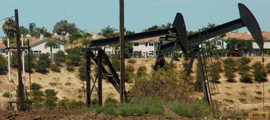 https://www.fractracker.org/a5ej20sjfwe/wp-content/uploads/2021/09/NRDC-Urban-Drilling-feature.jpg
667
1500
Kyle Ferrar, MPH
https://www.fractracker.org/a5ej20sjfwe/wp-content/uploads/2025/09/2025-Wordmark-Logo.png
Kyle Ferrar, MPH2021-09-14 14:26:442026-04-28 14:29:26It’s Time to Stop Urban Oil Drilling in Los Angeles
https://www.fractracker.org/a5ej20sjfwe/wp-content/uploads/2021/09/NRDC-Urban-Drilling-feature.jpg
667
1500
Kyle Ferrar, MPH
https://www.fractracker.org/a5ej20sjfwe/wp-content/uploads/2025/09/2025-Wordmark-Logo.png
Kyle Ferrar, MPH2021-09-14 14:26:442026-04-28 14:29:26It’s Time to Stop Urban Oil Drilling in Los Angeles https://www.fractracker.org/a5ej20sjfwe/wp-content/uploads/2021/09/National-Prison-Strike-poster-feature.jpg
667
1500
Kyle Ferrar, MPH
https://www.fractracker.org/a5ej20sjfwe/wp-content/uploads/2025/09/2025-Wordmark-Logo.png
Kyle Ferrar, MPH2021-09-09 08:00:082021-09-08 17:30:46California Prisons are Within 2,500’ of Oil and Gas Extraction
https://www.fractracker.org/a5ej20sjfwe/wp-content/uploads/2021/09/National-Prison-Strike-poster-feature.jpg
667
1500
Kyle Ferrar, MPH
https://www.fractracker.org/a5ej20sjfwe/wp-content/uploads/2025/09/2025-Wordmark-Logo.png
Kyle Ferrar, MPH2021-09-09 08:00:082021-09-08 17:30:46California Prisons are Within 2,500’ of Oil and Gas Extraction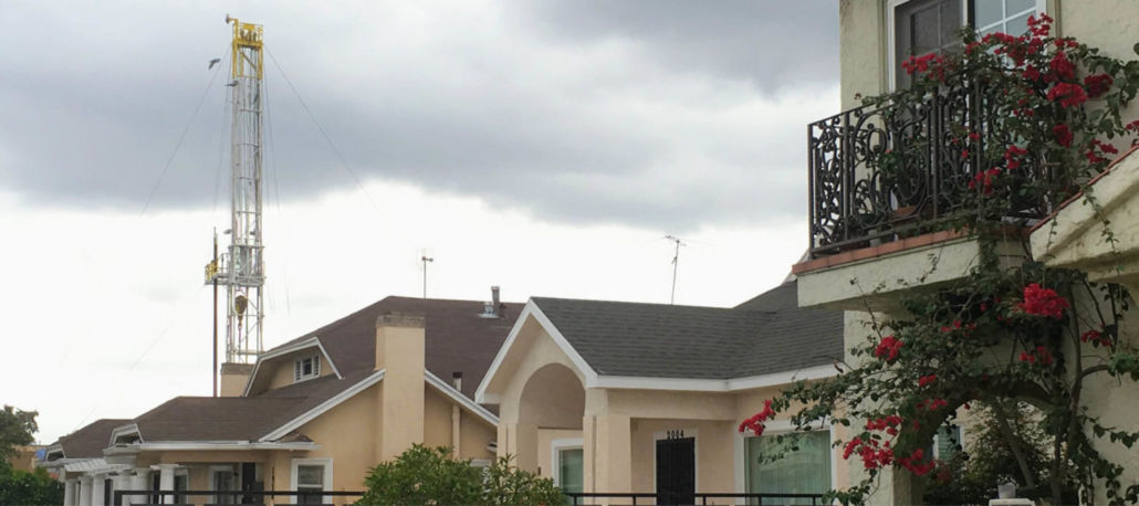 https://www.fractracker.org/a5ej20sjfwe/wp-content/uploads/2021/08/BLenker_infrastructure-oilrig-southLA-CA_Oct2017-feature.jpg
667
1500
Kyle Ferrar, MPH
https://www.fractracker.org/a5ej20sjfwe/wp-content/uploads/2025/09/2025-Wordmark-Logo.png
Kyle Ferrar, MPH2021-08-05 16:38:392021-08-05 16:38:39New Neighborhood Drilling Permits Issued While California Fails to Act on Public Health Rules
https://www.fractracker.org/a5ej20sjfwe/wp-content/uploads/2021/08/BLenker_infrastructure-oilrig-southLA-CA_Oct2017-feature.jpg
667
1500
Kyle Ferrar, MPH
https://www.fractracker.org/a5ej20sjfwe/wp-content/uploads/2025/09/2025-Wordmark-Logo.png
Kyle Ferrar, MPH2021-08-05 16:38:392021-08-05 16:38:39New Neighborhood Drilling Permits Issued While California Fails to Act on Public Health Rules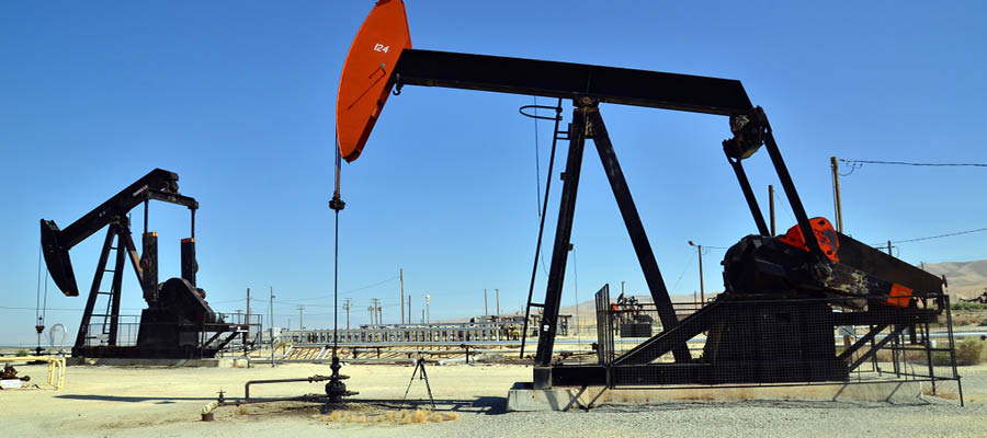 https://www.fractracker.org/a5ej20sjfwe/wp-content/uploads/2021/07/California-oil-drilling-feature.jpg
400
900
Kyle Ferrar, MPH
https://www.fractracker.org/a5ej20sjfwe/wp-content/uploads/2025/09/2025-Wordmark-Logo.png
Kyle Ferrar, MPH2021-07-26 13:56:312021-07-26 14:03:09California Oil & Gas Drilling Permits Drop in Response to Decreased Permit Applications to CalGEM
https://www.fractracker.org/a5ej20sjfwe/wp-content/uploads/2021/07/California-oil-fields-feature.jpg
667
1500
Kyle Ferrar, MPH
https://www.fractracker.org/a5ej20sjfwe/wp-content/uploads/2025/09/2025-Wordmark-Logo.png
Kyle Ferrar, MPH2021-07-20 16:32:222021-07-20 17:36:11California Denies Well Stimulation Permits
https://www.fractracker.org/a5ej20sjfwe/wp-content/uploads/2021/07/California-oil-drilling-feature.jpg
400
900
Kyle Ferrar, MPH
https://www.fractracker.org/a5ej20sjfwe/wp-content/uploads/2025/09/2025-Wordmark-Logo.png
Kyle Ferrar, MPH2021-07-26 13:56:312021-07-26 14:03:09California Oil & Gas Drilling Permits Drop in Response to Decreased Permit Applications to CalGEM
https://www.fractracker.org/a5ej20sjfwe/wp-content/uploads/2021/07/California-oil-fields-feature.jpg
667
1500
Kyle Ferrar, MPH
https://www.fractracker.org/a5ej20sjfwe/wp-content/uploads/2025/09/2025-Wordmark-Logo.png
Kyle Ferrar, MPH2021-07-20 16:32:222021-07-20 17:36:11California Denies Well Stimulation Permits https://www.fractracker.org/a5ej20sjfwe/wp-content/uploads/2021/03/Arvin-CA-well-sites-and-schools-feature-scaled.jpg
667
1500
Kyle Ferrar, MPH
https://www.fractracker.org/a5ej20sjfwe/wp-content/uploads/2025/09/2025-Wordmark-Logo.png
Kyle Ferrar, MPH2021-03-04 15:29:422021-04-15 15:14:45Kern County’s Drafted EIR Will Increase the Burden for Frontline Communities
https://www.fractracker.org/a5ej20sjfwe/wp-content/uploads/2021/02/Los-Angeles-skyline-feature-scaled.jpg
667
1500
Kyle Ferrar, MPH
https://www.fractracker.org/a5ej20sjfwe/wp-content/uploads/2025/09/2025-Wordmark-Logo.png
Kyle Ferrar, MPH2021-02-23 14:42:162021-04-15 14:08:42California Oil & Gas Setbacks Recommendations Memo
https://www.fractracker.org/a5ej20sjfwe/wp-content/uploads/2021/03/Arvin-CA-well-sites-and-schools-feature-scaled.jpg
667
1500
Kyle Ferrar, MPH
https://www.fractracker.org/a5ej20sjfwe/wp-content/uploads/2025/09/2025-Wordmark-Logo.png
Kyle Ferrar, MPH2021-03-04 15:29:422021-04-15 15:14:45Kern County’s Drafted EIR Will Increase the Burden for Frontline Communities
https://www.fractracker.org/a5ej20sjfwe/wp-content/uploads/2021/02/Los-Angeles-skyline-feature-scaled.jpg
667
1500
Kyle Ferrar, MPH
https://www.fractracker.org/a5ej20sjfwe/wp-content/uploads/2025/09/2025-Wordmark-Logo.png
Kyle Ferrar, MPH2021-02-23 14:42:162021-04-15 14:08:42California Oil & Gas Setbacks Recommendations Memo https://www.fractracker.org/a5ej20sjfwe/wp-content/uploads/2021/02/Figure-2.-There-are-50-operational-oil-and-gas-wells-permitted-on-California-state-lands-in-the-Sacramento-River-Delta-feature-scaled.jpg
667
1500
Kyle Ferrar, MPH
https://www.fractracker.org/a5ej20sjfwe/wp-content/uploads/2025/09/2025-Wordmark-Logo.png
Kyle Ferrar, MPH2021-02-12 17:42:002021-04-15 14:08:43Oil and Gas Wells on California State Lands
https://www.fractracker.org/a5ej20sjfwe/wp-content/uploads/2021/02/Figure-2.-There-are-50-operational-oil-and-gas-wells-permitted-on-California-state-lands-in-the-Sacramento-River-Delta-feature-scaled.jpg
667
1500
Kyle Ferrar, MPH
https://www.fractracker.org/a5ej20sjfwe/wp-content/uploads/2025/09/2025-Wordmark-Logo.png
Kyle Ferrar, MPH2021-02-12 17:42:002021-04-15 14:08:43Oil and Gas Wells on California State Lands https://www.fractracker.org/a5ej20sjfwe/wp-content/uploads/2020/12/CASetbacksMappic.jpg
614
1500
Kyle Ferrar, MPH
https://www.fractracker.org/a5ej20sjfwe/wp-content/uploads/2025/09/2025-Wordmark-Logo.png
Kyle Ferrar, MPH2020-12-17 13:45:242021-04-15 14:16:02People and Production: Reducing Risk in California Extraction
https://www.fractracker.org/a5ej20sjfwe/wp-content/uploads/2020/12/CASetbacksMappic.jpg
614
1500
Kyle Ferrar, MPH
https://www.fractracker.org/a5ej20sjfwe/wp-content/uploads/2025/09/2025-Wordmark-Logo.png
Kyle Ferrar, MPH2020-12-17 13:45:242021-04-15 14:16:02People and Production: Reducing Risk in California Extraction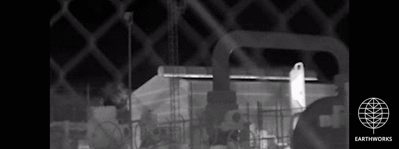 https://www.fractracker.org/a5ej20sjfwe/wp-content/uploads/2019/08/EQT-Tioga-Wide-7.gif
300
800
Kyle Ferrar, MPH
https://www.fractracker.org/a5ej20sjfwe/wp-content/uploads/2025/09/2025-Wordmark-Logo.png
Kyle Ferrar, MPH2020-11-18 12:40:132021-04-15 14:16:04Documenting emissions from new oil and gas wells in California
https://www.fractracker.org/a5ej20sjfwe/wp-content/uploads/2019/08/EQT-Tioga-Wide-7.gif
300
800
Kyle Ferrar, MPH
https://www.fractracker.org/a5ej20sjfwe/wp-content/uploads/2025/09/2025-Wordmark-Logo.png
Kyle Ferrar, MPH2020-11-18 12:40:132021-04-15 14:16:04Documenting emissions from new oil and gas wells in California https://www.fractracker.org/a5ej20sjfwe/wp-content/uploads/2020/09/Pump_Jack_at_the_Lost_Hills_Oil_Field_In_Central_California-feature.jpg
833
1875
Kyle Ferrar, MPH
https://www.fractracker.org/a5ej20sjfwe/wp-content/uploads/2025/09/2025-Wordmark-Logo.png
Kyle Ferrar, MPH2020-09-16 19:45:072021-04-15 14:16:08Recommendations for an EIR to prioritize Kern County Frontline Communities
https://www.fractracker.org/a5ej20sjfwe/wp-content/uploads/2020/09/Pump_Jack_at_the_Lost_Hills_Oil_Field_In_Central_California-feature.jpg
833
1875
Kyle Ferrar, MPH
https://www.fractracker.org/a5ej20sjfwe/wp-content/uploads/2025/09/2025-Wordmark-Logo.png
Kyle Ferrar, MPH2020-09-16 19:45:072021-04-15 14:16:08Recommendations for an EIR to prioritize Kern County Frontline Communities https://www.fractracker.org/a5ej20sjfwe/wp-content/uploads/2020/06/CalGEM-Drilling-and-Rework-Permits-2015-2020-feature.jpg
833
1875
Kyle Ferrar, MPH
https://www.fractracker.org/a5ej20sjfwe/wp-content/uploads/2025/09/2025-Wordmark-Logo.png
Kyle Ferrar, MPH2020-06-08 08:44:542021-04-15 14:16:46Systematic Racism in Kern County Oil and Gas Permitting Ordinance
https://www.fractracker.org/a5ej20sjfwe/wp-content/uploads/2020/06/CalGEM-Drilling-and-Rework-Permits-2015-2020-feature.jpg
833
1875
Kyle Ferrar, MPH
https://www.fractracker.org/a5ej20sjfwe/wp-content/uploads/2025/09/2025-Wordmark-Logo.png
Kyle Ferrar, MPH2020-06-08 08:44:542021-04-15 14:16:46Systematic Racism in Kern County Oil and Gas Permitting Ordinance https://www.fractracker.org/a5ej20sjfwe/wp-content/uploads/2020/04/Map-of-New-2020-Fracking-Permits-in-California.jpg
720
1500
Kyle Ferrar, MPH
https://www.fractracker.org/a5ej20sjfwe/wp-content/uploads/2025/09/2025-Wordmark-Logo.png
Kyle Ferrar, MPH2020-05-07 12:48:132021-04-15 14:16:49California, Back in Frack
https://www.fractracker.org/a5ej20sjfwe/wp-content/uploads/2020/04/California-well-pad.jpg
666
1500
Kyle Ferrar, MPH
https://www.fractracker.org/a5ej20sjfwe/wp-content/uploads/2025/09/2025-Wordmark-Logo.png
Kyle Ferrar, MPH2020-04-02 10:20:422021-04-15 14:16:50California Setback Analyses Summary
https://www.fractracker.org/a5ej20sjfwe/wp-content/uploads/2020/04/Map-of-New-2020-Fracking-Permits-in-California.jpg
720
1500
Kyle Ferrar, MPH
https://www.fractracker.org/a5ej20sjfwe/wp-content/uploads/2025/09/2025-Wordmark-Logo.png
Kyle Ferrar, MPH2020-05-07 12:48:132021-04-15 14:16:49California, Back in Frack
https://www.fractracker.org/a5ej20sjfwe/wp-content/uploads/2020/04/California-well-pad.jpg
666
1500
Kyle Ferrar, MPH
https://www.fractracker.org/a5ej20sjfwe/wp-content/uploads/2025/09/2025-Wordmark-Logo.png
Kyle Ferrar, MPH2020-04-02 10:20:422021-04-15 14:16:50California Setback Analyses Summary https://www.fractracker.org/a5ej20sjfwe/wp-content/uploads/2020/02/National-map-feature-3.png
400
900
Erica Jackson
https://www.fractracker.org/a5ej20sjfwe/wp-content/uploads/2025/09/2025-Wordmark-Logo.png
Erica Jackson2020-02-28 17:35:142022-05-02 15:21:42National Energy and Petrochemical Map
https://www.fractracker.org/a5ej20sjfwe/wp-content/uploads/2020/02/National-map-feature-3.png
400
900
Erica Jackson
https://www.fractracker.org/a5ej20sjfwe/wp-content/uploads/2025/09/2025-Wordmark-Logo.png
Erica Jackson2020-02-28 17:35:142022-05-02 15:21:42National Energy and Petrochemical Map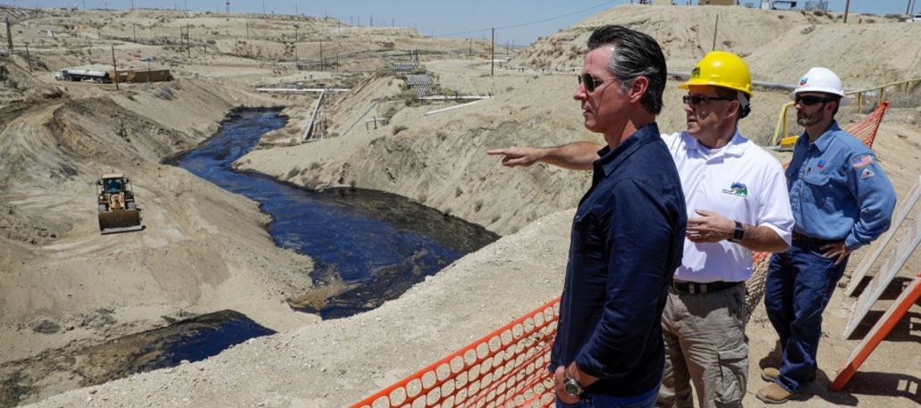 https://www.fractracker.org/a5ej20sjfwe/wp-content/uploads/2020/01/California-Governor-Gavin-Newsom--scaled.jpg
666
1500
Kyle Ferrar, MPH
https://www.fractracker.org/a5ej20sjfwe/wp-content/uploads/2025/09/2025-Wordmark-Logo.png
Kyle Ferrar, MPH2020-02-24 10:09:182021-04-15 14:55:29Governor Newsom Must Do More to Address the Cause of Oil Spill Surface Expressions
https://www.fractracker.org/a5ej20sjfwe/wp-content/uploads/2020/01/California-Governor-Gavin-Newsom--scaled.jpg
666
1500
Kyle Ferrar, MPH
https://www.fractracker.org/a5ej20sjfwe/wp-content/uploads/2025/09/2025-Wordmark-Logo.png
Kyle Ferrar, MPH2020-02-24 10:09:182021-04-15 14:55:29Governor Newsom Must Do More to Address the Cause of Oil Spill Surface Expressions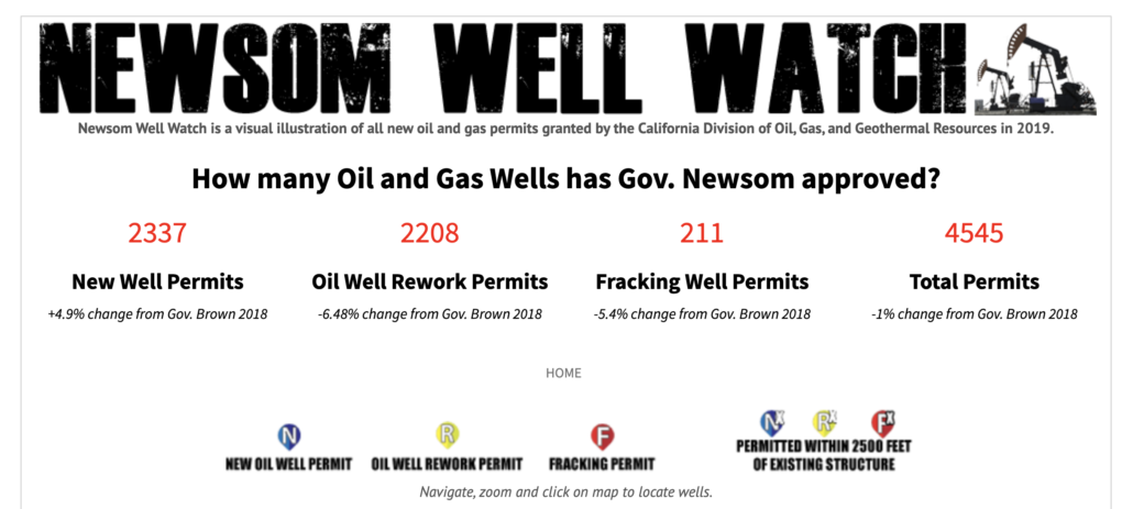 https://www.fractracker.org/a5ej20sjfwe/wp-content/uploads/2020/02/Screen-Shot-2020-02-21-at-2.22.05-PM.png
674
1500
Kyle Ferrar, MPH
https://www.fractracker.org/a5ej20sjfwe/wp-content/uploads/2025/09/2025-Wordmark-Logo.png
Kyle Ferrar, MPH2020-02-22 13:29:222021-04-15 14:55:30Oil & Gas Well Permits Issued By Newsom Administration Rival Those Issued Under Gov. Jerry Brown
https://www.fractracker.org/a5ej20sjfwe/wp-content/uploads/2020/02/Screen-Shot-2020-02-21-at-2.22.05-PM.png
674
1500
Kyle Ferrar, MPH
https://www.fractracker.org/a5ej20sjfwe/wp-content/uploads/2025/09/2025-Wordmark-Logo.png
Kyle Ferrar, MPH2020-02-22 13:29:222021-04-15 14:55:30Oil & Gas Well Permits Issued By Newsom Administration Rival Those Issued Under Gov. Jerry Brown https://www.fractracker.org/a5ej20sjfwe/wp-content/uploads/2019/11/Newsom-Well-Watch-Feature-scaled.jpg
667
1500
Kyle Ferrar, MPH
https://www.fractracker.org/a5ej20sjfwe/wp-content/uploads/2025/09/2025-Wordmark-Logo.png
Kyle Ferrar, MPH2019-11-19 20:06:282021-04-15 14:55:36California is Frack Free, for the Moment
https://www.fractracker.org/a5ej20sjfwe/wp-content/uploads/2019/11/Newsom-Well-Watch-Feature-scaled.jpg
667
1500
Kyle Ferrar, MPH
https://www.fractracker.org/a5ej20sjfwe/wp-content/uploads/2025/09/2025-Wordmark-Logo.png
Kyle Ferrar, MPH2019-11-19 20:06:282021-04-15 14:55:36California is Frack Free, for the Moment https://www.fractracker.org/a5ej20sjfwe/wp-content/uploads/2019/07/inglewood-field-ca-feature-1-scaled.jpg
667
1500
Kyle Ferrar, MPH
https://www.fractracker.org/a5ej20sjfwe/wp-content/uploads/2025/09/2025-Wordmark-Logo.png
Kyle Ferrar, MPH2019-07-11 14:48:462021-04-15 14:56:28Permitting New Oil and Gas Wells Under the Newsom Administration
https://www.fractracker.org/a5ej20sjfwe/wp-content/uploads/2019/07/inglewood-field-ca-feature-1-scaled.jpg
667
1500
Kyle Ferrar, MPH
https://www.fractracker.org/a5ej20sjfwe/wp-content/uploads/2025/09/2025-Wordmark-Logo.png
Kyle Ferrar, MPH2019-07-11 14:48:462021-04-15 14:56:28Permitting New Oil and Gas Wells Under the Newsom Administration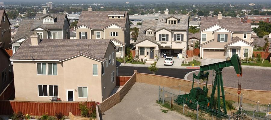 https://www.fractracker.org/a5ej20sjfwe/wp-content/uploads/2019/06/SignalHill_DavidMcNew_GettyImages_edit.jpg
400
900
Kyle Ferrar, MPH
https://www.fractracker.org/a5ej20sjfwe/wp-content/uploads/2025/09/2025-Wordmark-Logo.png
Kyle Ferrar, MPH2019-07-02 12:03:382021-04-15 14:56:29Impact of a 2,500′ Oil and Gas Well Setback in California
https://www.fractracker.org/a5ej20sjfwe/wp-content/uploads/2019/03/IdleWellsHathaway_resize.jpg
400
900
Kyle Ferrar, MPH
https://www.fractracker.org/a5ej20sjfwe/wp-content/uploads/2025/09/2025-Wordmark-Logo.png
Kyle Ferrar, MPH2019-04-03 11:30:582021-04-15 14:56:34Idle Wells are a Major Risk
https://www.fractracker.org/a5ej20sjfwe/wp-content/uploads/2019/06/SignalHill_DavidMcNew_GettyImages_edit.jpg
400
900
Kyle Ferrar, MPH
https://www.fractracker.org/a5ej20sjfwe/wp-content/uploads/2025/09/2025-Wordmark-Logo.png
Kyle Ferrar, MPH2019-07-02 12:03:382021-04-15 14:56:29Impact of a 2,500′ Oil and Gas Well Setback in California
https://www.fractracker.org/a5ej20sjfwe/wp-content/uploads/2019/03/IdleWellsHathaway_resize.jpg
400
900
Kyle Ferrar, MPH
https://www.fractracker.org/a5ej20sjfwe/wp-content/uploads/2025/09/2025-Wordmark-Logo.png
Kyle Ferrar, MPH2019-04-03 11:30:582021-04-15 14:56:34Idle Wells are a Major Risk https://www.fractracker.org/a5ej20sjfwe/wp-content/uploads/2019/02/San-Bruno-Aftermath-feature-image.png
400
900
Guest Author
https://www.fractracker.org/a5ej20sjfwe/wp-content/uploads/2025/09/2025-Wordmark-Logo.png
Guest Author2019-02-08 19:21:012021-04-15 14:56:55Unnatural Disasters
https://www.fractracker.org/a5ej20sjfwe/wp-content/uploads/2019/02/San-Bruno-Aftermath-feature-image.png
400
900
Guest Author
https://www.fractracker.org/a5ej20sjfwe/wp-content/uploads/2025/09/2025-Wordmark-Logo.png
Guest Author2019-02-08 19:21:012021-04-15 14:56:55Unnatural Disasters![]()
216 Franklin St, Suite 400, Johnstown, PA 15901
Phone: +1 (717) 303-0403 | info@fractracker.org
FracTracker Alliance is a 501(c)3 non-profit: Tax identification number: 80-0844297