The Falcon Pipeline: Technical Deficiencies
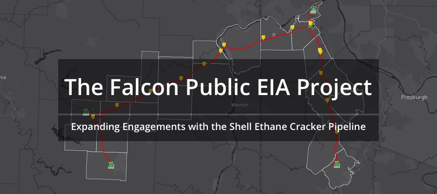
Part of the Falcon Public EIA Project
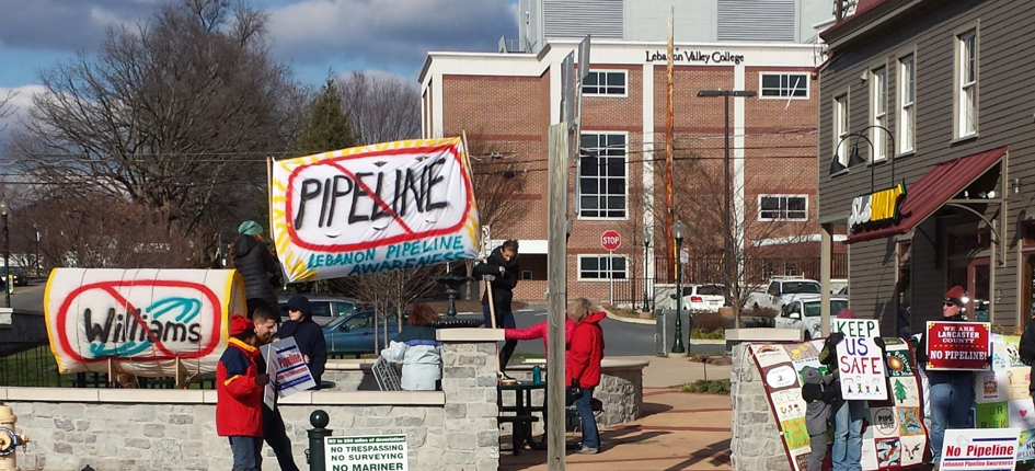
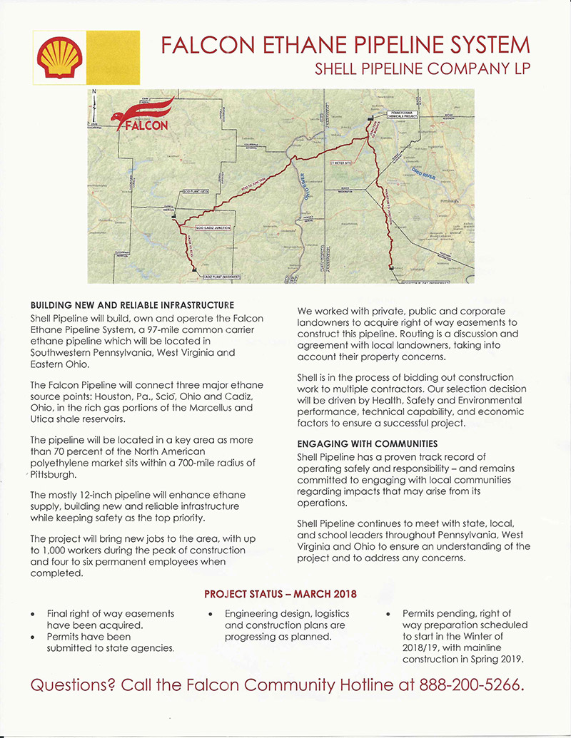
In August 2016, Shell announced plans for the “Falcon Ethane Pipeline System,” a 97-mile pipeline network intended to feed Shell’s ethane cracker facility in Beaver County, Pennsylvania. In response to available data, FracTracker launched the Falcon Public EIA Project in January of 2018 to unearth the environmental and public health impacts of the proposed pipeline. As part of that project, today we explore Shell’s Chapter 105 application and the deficiencies the Pennsylvania Department of Environmental Protection (DEP) cited after reviewing Shell’s application.
Just a heads up… there are a lot.
Shell originally submitted a Chapter 105 application to the DEP to receive a permit for water obstruction and encroachment. The DEP began reviewing the application in January of 2018. On June 1st, they sent Shell technical deficiency letters listing several issues with the application. Shell responded to these deficiencies on August 1st.
Now, it’s up to the DEP to decide if Shell’s response is adequate, and if the department should go ahead and approve the application or require more work from Shell. Explore the technical deficiencies below for more information.
Technical Deficiencies
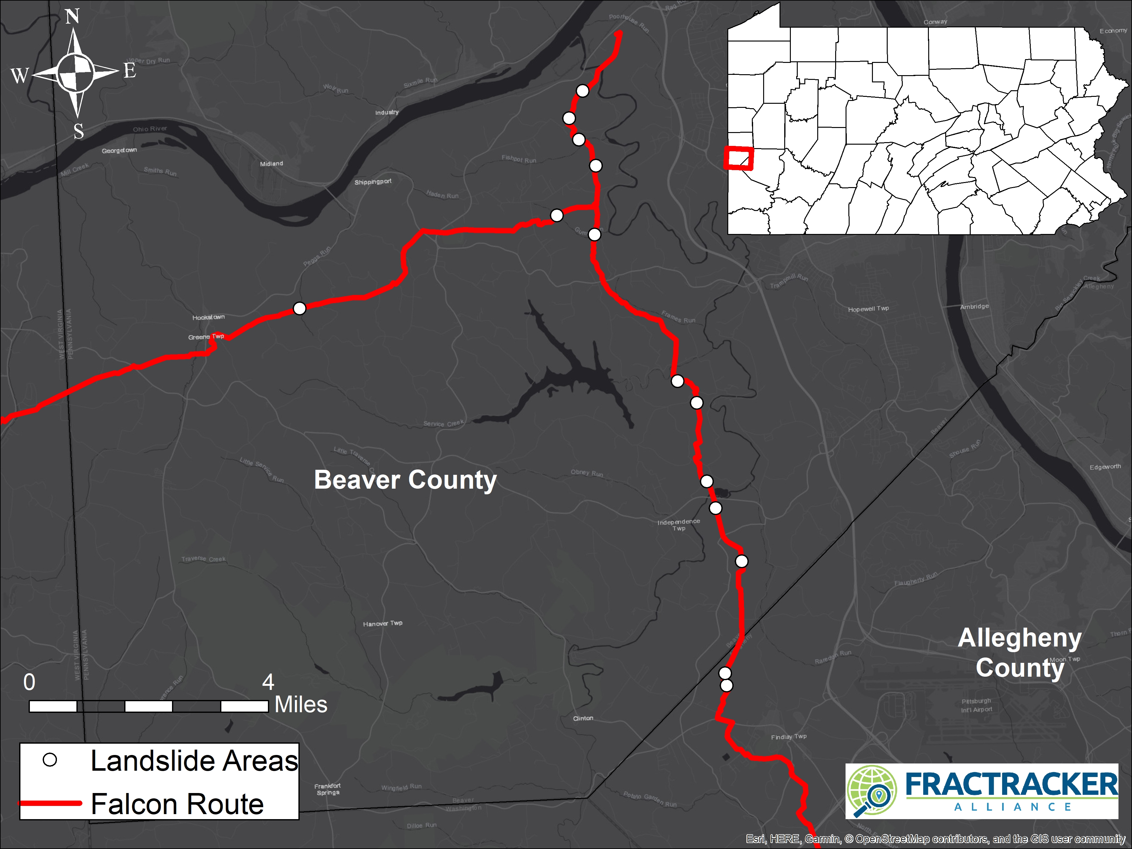
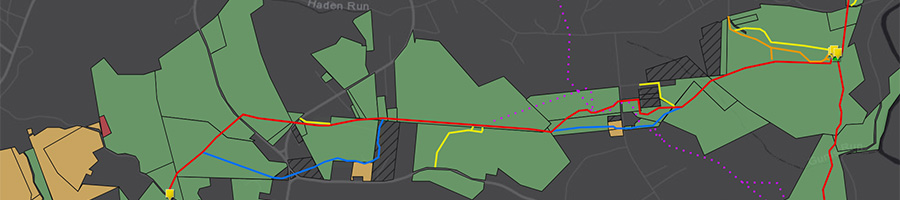
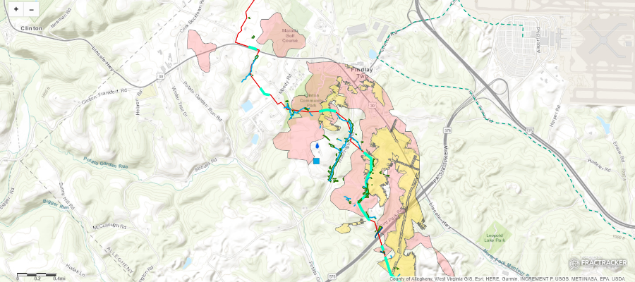
Below is a map that highlights several of the deficiencies the DEP found with Shell’s application and a brief explanation of each one. Expand the map full-screen to explore more layers – Some layers only become visible when you zoom in due to the level of detail they display.
View Map Full Screen | How Our Maps Work
Next, we’ll walk you through the technical deficiencies, which we have broken down into the following categories:
- Wetlands, rivers, streams
- Stormwater control
- Public health and safety (drinking water & trails)
- Conservation areas
- Alternative routes
- Geological concerns (including mining issues)
- Documentation issues
1. Wetlands, Rivers, & Streams
Water withdrawal from rivers and discharge
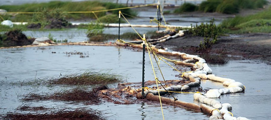
- B2 A2 W2 The project will discharge waste water from an industrial activity to a dry swale, surface water, ground water, or an existing sanitary sewer system or separate storm water system. The DEP requested that Shell identify and describe this discharge, as the DEP’s Clean Water Program must authorize discharges. Shell stated that water will be discharged from hydrostatic testing, (which ensures a pipeline can withstand high pressure by pumping water through it to test for leaks), and a PAG-10 permit (needed for hydrostatic test water discharge) was submitted to the DEP July 27, 2018 with the locations of discharge. Drawings of the discharges are in Attachment O. (The locations of the discharges were not included in Shell’s public response to this deficiency.)
- B33 A31 W31 Shell will be withdrawing water for hydrostatic testing. The DEP asked Shell to explain the intake and discharge methods so the DEP can decide if these should be included as impacts. The DEP also asked Shell to provide the location of intake and discharge. The DEP’s Clean Water Program must authorize discharges. In response, Shell stated that water will be withdrawn from Raccoon Creek and the Ohio River in West Virginia. The specific locations are listed in the PAG-10 permit, submitted to the DEP in July. Drawings of the discharges are included in Attachment O.
Wetlands and Streams
- B5 A3 W4 The DEP asked Shell to identify the presence of wetlands within the project area that are identified by the US Fish & Wildlife Service’s National Wetlands Inventory (NWI) data system, and provide data on how they may be impacted by the proposed pipeline. Shell identified one NWI wetland in Beaver County, but did not delineate or provide information on it, due to safety concerns (it’s on a steep cliff). This wetland will be crossed via HDD (horizontal directional drill). In Allegheny County, there is an NWI wetland that Shell also did not provide data on. This wetland was not initially evident, and when staff returned to survey it, the property owner did not let them access the site because they did not want a pipeline on their property. According to Shell, this NWI wetland is not within the “Project’s Limit of Disturbance.” In Washington County, Shell stated that “all of the NWI-mapped wetlands that were determined not to be wetlands have been accounted for in Washington County. These NWI wetlands were all located in an area that had been previously strip-mined and due to mining activities, those wetlands are no longer there. Data were taken for these areas and included… separately as Attachment D.” Also in Washington County is an NWI wetland located above the Panhandle Trail, which Shell determined to be outside of the study area and therefore did not collect data on it. This wetland is not on the map, but Shell did provide this image of it.
- B6 A4 W5 The DEP requested that Shell match off-line wetland data with sampling point locations from study area maps. In response, Shell placed offline data sheets in the order that they are in Table 3 in the Wetlands Delineation Report and in Table 4 in the Watercourse Delineation Report.
- B7 A5 W6 Shell needed to discuss the types and conditions of riverine resources that the project impacts. Specifically, how the conditions of these resources relate to their hydrological functions, biogeochemical functions, and habitat attributes. These are discussed under question 7 for Beaver County, question 5 for Allegheny County, and question 6 for Washington County.
- B8 A6 W7 Shell needed to discuss the types and conditions of wetlands that the project impacts. Specifically, how the conditions of these wetlands contribute to their hydrological functions, biogeochemical functions, and habitat attributes. Shell also needed to discuss impacts to wetlands that will be temporarily impacted, as it previously only discussed wetlands facing permanent impacts. These are discussed under question 8 for Beaver County, question 6 for Allegheny County, and question 7 for Washington County.
- B9 A7 W8 The DEP asked Shell to evaluate the impact of open cut installation on wetlands with perched water tables and/or confining layers. Perched water tables have an impermeable confining layer (such as clay) between them and the main water table below. If open cut methods are used, the confining layer is destroyed and this water table will be lost. In Beaver County, Shell identified one wetland (W-PA-170222-MRK-002) will be open cut. If it is perched, Shell states it will replace the confining layer “along the same horizon during pipeline backfilling, and then [compact the layer] so that hydrology may be maintained.” Shell will also put trench plugs “on either side of the wetland on the ROW to prevent water from migrating out on the sides.” In Allegheny County, there are three wetlands potentially on perched water tables that will be open cut: W-PA-160401-MRK-006, W-PA-161220-MRK-001, and W-PA-161220-MRK-002.In Washington County, there are three wetlands potentially on perched water tables that will be open cut: W-PA-160407-JLK-002, W-PA-151203-MRK-005, and W-PA-151203-MRK-006.
- A11 The DEP asked Shell to evaluate if any wetlands can be classified as “exceptional value” due to their proximity to nesting areas of the northern harrier (a threatened species in Pennsylvania). Wetlands are exceptional value if they serve as habitat for threatened or endangered species, or if they are hydrologically connected to or located within 0.5 miles of wetlands that maintain habitat for the species in the wetland. Shell determined that there are six wetlands that could be nesting areas for northern harriers, and therefore are exceptional value (W-PA-170207-MRK-002, W-PA-161205-WRA-001, W-PA-170207-MRK-003, W-PA-170207-MRK-001, W-PA-170113-MRK-008, W-PA-170113-MRK-001). Three of these wetlands are within the project’s LOD (W-PA-170207-MRK-002, W-PA-161205-WRA-001, W-PA-170207-MRK-003).
- B13 A10 W11 The DEP asked Shell to evaluate whether the proposed Falcon Pipeline will impact wetlands that are of “exceptional value” based on their proximity to public water systems. Wetlands can be considered “exceptional value” if they are located along public or private drinking water supplies (surface or ground water), and help maintain the quality or quantity of the supply. Shell stated that the (potentially man made) ponds near public water supply A could be considered exceptional value, however, they are located outside of the project’s study area and were not delineated, therefore Shell does not have information on them or their impact to this well. There were no other wetlands Shell considered to be exceptional value based on their proximity to public water systems.
- B21 There were two protected plant species- harbinger of spring (PA threatened) and purple rocket (PA endangered)- located within the Raccoon Creek floodplain. The DEP asked Shell to evaluate whether there are wetlands in the project area that should be considered “exceptional value” due to their proximity to these species. Wetlands are considered “exceptional value” if they serve as habitat for a threatened or endangered plant or animal species. They are also exceptional value if they are hydrologically connected to or located within 0.5 miles of wetlands that maintain the habitat of the species. There are six wetlands near populations of these plant populations: W-PA-151014-MRK-001, W-PA-151013-MRK-002, -003, and -004, W-PA-170407-JLK-001, W-PA151013-MRK-001. However, Shell stated that the harbinger of spring is not dependent on wetland habitat for survival and the species is considered an upland plant species (because it is not listed on Eastern Mountains and Piedmont List or on the National Wetland Plant List). Purple rocket is listed as a “Facultative Wetland Plant” (FACW) on both lists. However, Shell stated that, “although it is a FACW, this plant is not one that occurs in wetlands,” and the population of purple rocket was found in an upland, disturbed area. Therefore, Shell determined that none of these wetlands are considered exceptional value.
- B23 A21 W21 Shell needs to assess cumulative impacts to wetlands from the proposed pipeline and other existing projects and potential future projects. These are discussed in the Cumulative Impact Assessment document, Sections 4.1 and 4.2, and Tables B1 and B2.
- B24 A22 W22 Shell needed to provide an explanation of how it will restore wetlands and streams disturbed during construction. The explanation needed to include information on seed mixes, shrubs, and trees that will restore stream banks and riparian areas.
- B26 A24 W24 Shell needed to provide a table that lists, describes, and quantifies permanent impacts to wetlands and watercourses. Shell stated that there are no permanent fills associated with the project, but there will be permanent conversion impacts to the following wetlands. They total 10,862 ft2 or 0.25 acres in Beaver County, 5,166 ft2 (0.12 acres) in Allegheny County, and 4971 ft2 (0.11 acres) in Washington County. (W-PA-151013-JLK-005, W-PA-161202-MRK-001, W-PA-160404-MRK-001, W-PA-160412-CBA-004, W-PA-160412-CBA-001, W-PA-161205-WRA-003, W-PA-160401-MRK-005, W-PA-170213-JLK-003, W-PA-160406-MRK-001, W-PA-170413-RCL-005, W-PA-170214-CBA-005.)
- B27 A25 W25 Shell needed to provide more information on the Neshannock Creek Restoration site, including a master restoration plan for the entire site. This mitigation is required to offset conversion impacts to wetlands along the pipeline route. The plan for the site is documented here.
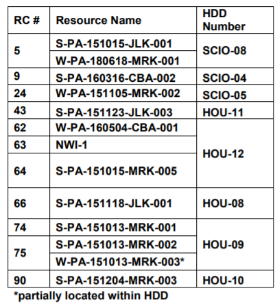
- B28 A26 W26 Shell needed to provide the location and resource crossing number for the HDDs in PA. They are listed in these tables:
Allegheny County: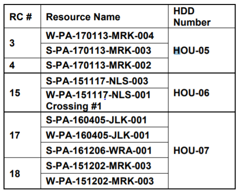
Washington County:
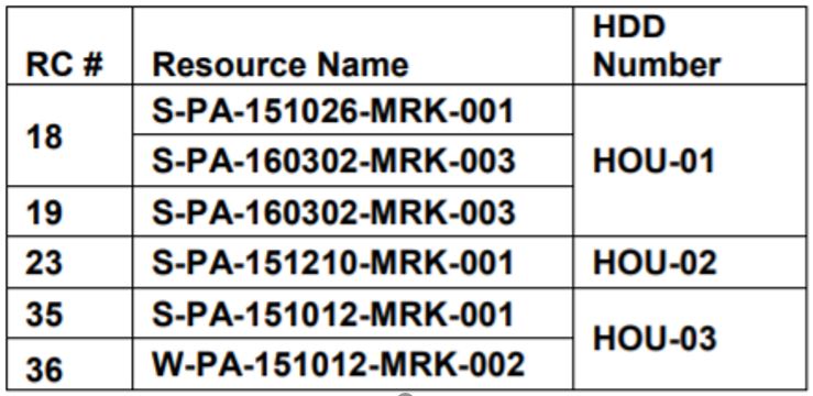
Beaver County:
2. Stormwater control
- B3 A1 W1 Shell indicated that the project was in a floodplain project by the Commonwealth, a political subdivision of the commonwealth or a public utility. The DEP asked for an identification of this floodplain project, to which Shell responded that it misunderstood the question and the pipeline will not go through a floodplain project by one of these entities, but rather a floodway. The pipeline will pass many floodways, which are listed in Table 1 in separate documents for Beaver County, Allegheny County, and Washington County.
- W3 The DEP requested that Shell provide an analysis of impact to Act 167 plans. Act 167 requires counties to create stormwater management plans and municipalities to adopt ordinances to regulate development in accordance with these plans. The pipeline route occurs in areas with Act 167 plans in Chartiers Township, Mount Pleasant Township, and Robinson Township.
3. Public health and safety
- B1 The proposed pipeline does not meet the provisions of a zoning ordinance or have zoning approval in a particular area. Specifically, in Independence Township, the pipeline is within setback distances of places of congregation and/or of residences. One example is the Beaver County Conservation District, considered a place of congregation. Shell responded to this deficiency, saying it is working with Independence Township to obtain necessary approvals, and the township will “officially remove the pipeline ordinance from their records and no variances or permits will be required.”
- B10 A8 W9 The DEP requested that Shell evaluate and discuss how the pipeline may impact public water systems that are within 1 mile of the pipeline route. Shell located 12 sites within a mile, most of which are ground water wells. One site is the Ambridge Water Authority, which provides drinking water for an estimated 30,000 people. Shell stated that impacts “might include an Inadvertent Return (IR) causing a bentonite slurry mix to enter the supply, which might contaminate the supply for any wells that are located near an HDD site or construction equipment.” Shell stated that all wells are a minimum of 1000 feet outside construction zones and built in thick bedrock which will minimize threat on contamination. The sites within 1 mile include:
- Youthtowne Barn
- Beaver County Conservation District
- Independence Elementary School
- Independence Volunteer Fire Department
- McConnell’s Farm and Market, Inc
- Ambridge Water Authority- Independence Township
- Ambridge Water Authority- Raccoon Township
- Hookstown Free Methodist Church
- Hookstown Fair
- Hookstown Grange
- South Side Memorial Post 952
- Jack’s Diner
- NOVA Chemical, Inc
- B11 A9 W10 The DEP asked Shell to discuss efforts to avoid/minimize impacts to the above public water systems, and suggested that efforts “might include, but are not limited to, considering alternative locations, routings or design for the proposed pipeline; providing provisions for shut-off in the event of break or rupture; etc.” Shell stated that the route avoids direct impacts to groundwater wells and surface water intake. Shell will provide water buffalos if wells are contaminated, and drill new wells if necessary. There are mainline valves approximately 7 to 7.5 miles apart that can automatically shut off the flow of ethane. There will also be staff living within the project area that can quickly respond to issues.
- B12 The pipeline crosses headwaters of the Ambridge Reservoir and the Reservoir’s raw water service pipeline, which supplies water to 30,000 residents. The DEP noted significant public concern regarding this crossing, and asked Shell to evaluate and discuss the pipeline’s potential to affect the Reservoir and public water supply service. The DEP also asked Shell to elaborate on efforts to avoid/minimize impacts, and what measures will be implemented to mitigate any unavoidable impacts. In response, Shell stated the pipeline will cross the raw water line via an HDD 31 feet below the line. Shell explained that the water service line is made of pre-stressed concrete, which cannot be retrofitted in the field if a break occurs. It can take six weeks for pipe joints to be made and delivered from Ohio if there is a rupture. Shell stated it will supply extra pipe joints so the Ambridge Water Authority can have pieces on deck in case of a break. Shell also outlined the protective coatings and design of the HDD portion of the pipeline that will cross the water line, and said valves that can shut off the pipeline are located 2.4 miles from one side of the water line and 3.5 on the other.
- A17 W17 The DEP asked Shell to consider the proposed pipeline’s effect on the Montour Trail, a multi-use, recreational trail, and to consider re-routes that would avoid impacts to the Trail. Shell determined that routing around the trail is not feasible. Shell will use conventional bore or HDD methods. If the trail needs to be temporarily closed during construction, operation, or maintenance, Shell will notify the trail owner and provide alternate temporary access for trail users. Shell will also cross the Panhandle Trail by HDD. The entrance and exit sights of the bore will not be on the trail’s property. Shell has “unlimited ingress and egress over Owners property” for inspections, repair and maintenance of the pipeline, and in case of emergency situations.
- B29 A27 W27 Shell needed to revise the “Shell Pipeline HDD Procedure” to include HDD site feasibility analysis, inadvertent return risk assessment, water supply protection, agency contact information, etc. Shell’s response is included in the document, Inadvertent Returns from HDD: Assessment, Preparedness, Prevention and Response Plan.
- B30 A28 W28 Shell needed to include a preboring geologic evaluation to determine if drinking water supplies will be impacted around boring locations. Shell also needed to discuss how it will verify that drinking water sources and aquifers are protected and what measures will be taken in the event that they are impacted. Shell’s response is included as Appendix C to this document.
4. Conservation
- B19 A18 W18 19A 19W – There are many areas important for the region’s biodiversity and natural heritage that the proposed pipeline passes near or through. The DEP asked Shell to evaluate impacts to these areas. Information on them is available from the Pennsylvania Natural Heritage Program. They include:
- Ambridge Reservoir Valleys Natural Heritage Area
- Lower Raccoon Creek Natural Heritage Area
- Raccoon Creek Valley and Wildflower Reserve Natural Heritage Area
- Raccoon Creek Floodplain Biologically Diverse Area
- Raccoon Creek Landscape Conservation Area
- Clinton Wetlands Biologically Diverse Area
- Raccoon Creek Landscape Conservation Area
- Raccoon Creek Valley & State Park Important Bird Area – Regarding the Important Bird Area, Shell stated that 23 miles of the pipeline is located within this area. Shell has not been able to get in contact with the National Audobon SW PA office. Shell added that the only waterbody large enough in the project area to support the documented waterfowl is the open water at Beaver County Conservation District. Shell stated that “an outlet has been installed at the far end of the lake to restore it to more of a wetland and less of a lake, as it was originally designed.” Raccoon Creek Valley is also a passageway for migratory birds, which are protected under the Migratory Bird Treaty Act. Shell stated that less than 2% of this Important Bird Area will be permanently impacted by pipeline construction and installation.
5. Alternative locations
- B17 A15 W15 The DEP asked Shell to revise its current alternatives and provide a more detailed “analysis of the alternative locations and routes that were considered to avoid or minimize adverse environmental impacts.” The alternatives are discussed in Section 9 of Shell’s Comprehensive Environmental Assessment.
- B18 16A 16W According to the DEP, “18.5 of the 45 miles (41%) of the proposed pipeline are parallel to or adjacent to existing right-of-ways (ROWs).” The DEP asked Shell to see if there are additional opportunities to build the pipeline within existing ROWs, with the hope of reducing environmental impacts. In response, Shell discussed the additional ROWs that were considered (along Mariner West) but ultimately rejected. Shell discusses these routes more in Section 9.1 of the Comprehensive Environmental Assessment.
- B32 A30 W30 The DEP asked Shell to discuss the feasibility of several changes to the proposed pipeline’s route, including avoiding impacts to wetlands, relocating resource crossings, moving valve sites outside of wetlands, moving HDD locations, and evaluating the impact to a coal refuse pile (the pipeline crosses underneath at least one pile via HDD). These reroutes are discussed under question 32 for Beaver County, question 30 for Allegheny County, and question 30 for Washington County.
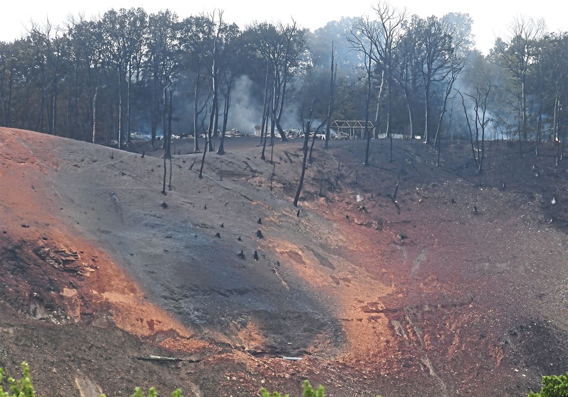
6. Geological concerns
- B14 12A 12W The pipeline is located in previously coal mined areas. The DEP asked Shell to provide a map of the pipeline that showed these mining areas, and GIS shape files with this information. Shell’s response is included in the HDD Subsurface Investigation Reports, which includes the following table of the extent of mined areas along the pipeline route:
- B15 A13 W13 The pipeline is located in coal mined areas, which could be susceptible to subsidence and/or mine water discharge. The DEP requested that Shell revise drawings to show the limits of previously mined areas, depth of cover over the mine workings in areas the proposed pipeline crosses through, and the distance between mine workings and the proposed pipeline. Furthermore, the DEP asked Shell to “evaluate and discuss the potential for a subsidence event compromising the utility line, and the potential to create a mine water discharge.” Shell discusses this in Appendix B of this this document and in the Mining Summary Report. Shell also identifies the following areas as being at risk for coal mine discharge: HOU MM 1.2, HOU MM 8.9 (proposed HDD), HOU MM 12.1, HOU MM 12.95, HOU MM 13.1, HOU MM 13.6, HOU MM 17.4, and HOU MM 17.65 (proposed HDD).
- B16 A14 14W The DEP requested that Shell include areas where the pipeline will cross active mining permit boundaries. There is one active mining permit boundary that intersects the proposed pipeline, the Rosebud Mine in Beaver County.
- B31 A29 W29 Shell needed to evaluate the potential for the project to encounter areas underlain by carbonate bedrock and landslide prone areas. Carbonate bedrock is indicative of a karst landscape, meaning an area likely to have underground sinkholes and caves. The DEP also asked Shell to discuss precautionary methods taken during construction in these areas. Shell’s response is included in the Carbonate Rock Analysis and Slope Stability and Investigation Report. The Carbonate Rock Analysis report shows that carbonate bedrock was encountered in 20 out of 40 of the borings taken during the analysis.
7. Documentation
- B4 The PA DEP asked Shell to describe the structures and activities that occur within junction sites. Shell responded that there will be a Junction Custody Transfer Meter Station at the site, and provided maps of the site.
- B22 20A 20w The DEP requested that Shell revise their Comprehensive Environmental Assessment to include alternatives, impacts, and mitigation items that were previously included in other sections of their environmental assessment.
- B25 A23 W23 The DEP asked Shell to provide a copy of the Mitigation Bank Credit Availability Letter from First Pennsylvania Resource, LLC. In response, Shell stated the Letter is no longer needed because “the permanent stream and wetland fills have been removed from this project.”
- B34 A32 W32 The DEP asked Shell to include a copy of the Preparedness, Prevention, and Contingency Plan.
- B35 A33 W33 Shell needs to include all of the above modifications to the application in the Chapter 103 permit application.
Conclusion
As evidenced by the list above, the proposed Falcon Pipeline poses a variety of threats to Pennsylvania’s natural resources, wildlife, and public health – but this deficiencies list is likely not complete. The pipeline also passes through West Virginia and Ohio, and if completed, will likely attract more pipelines to the area. As it feeds Shell’s ethane cracker plant in Beaver County, it is a major step towards the region becoming a hub for plastic manufacturing. Therefore, the public response to the above deficiencies and the decision the DEP makes regarding them will have major implications for the Ohio River Valley’s future.
Of note: The DEP’s letters and Shell’s response to them are available to the public in separate documents for Allegheny, Beaver, and Washington Counties.
By Erica Jackson, Community Outreach and Communications Specialist