Extractive industry uses propaganda to protect private profits at the expense of the public interest. According to the evidence, there is reason to believe that carbon capture and storage (CCS) is one such scheme.
There has been increasing focus on using hydrogen gas as a fuel, but most hydrogen is currently formed from methane, which could lead to more fracking.
https://www.fractracker.org/a5ej20sjfwe/wp-content/uploads/2022/06/TAuch_Infrastructure-OilRefinery_DowntownToledo-ToledoOil-LucasCounty-OH_Lighthawk_Sept2021.jpg6671500Matt Kelso, BAhttps://www.fractracker.org/a5ej20sjfwe/wp-content/uploads/2025/09/2025-Wordmark-Logo.pngMatt Kelso, BA2022-06-21 15:46:522024-06-18 10:53:27Does Hydrogen Have a Role in our Energy Future?
We first released this map in February of 2020. In the year since, the world’s energy systems have experienced record changes. Explore the interactive map, updated by FracTracker Alliance in April, 2021.
https://www.fractracker.org/a5ej20sjfwe/wp-content/uploads/2021/06/National-Map-2021-Feature.jpg6671500Erica Jacksonhttps://www.fractracker.org/a5ej20sjfwe/wp-content/uploads/2025/09/2025-Wordmark-Logo.pngErica Jackson2021-06-30 08:00:252022-05-02 15:24:21Updated National Energy and Petrochemical Map
The map below shows 6,950 total incidents since 2010, translating to 1.7 incidents per day. Pipelines are dangerous, in part because regulation around them is ineffective.
A new collaboration between FracTracker Alliance and Algalita is aiming to help middle school and high school students understand the connection between plastics and fracking — and the wide ranging implications for climate change, environmental injustice, and human health.
Most young people today understand that plastics are problematic. But, there is still often a disconnect between the symptom of plastics in our oceans, and the root causes of the problem. Algalita’s mission is to empower a new generation of critical thinkers to shift the broken and unjust systems that are causing the plastic pollution crisis. Algalita’s strategy is creating educational experiences directly with the movement’s diverse leaders, and this new project with FracTracker is a perfect example.
Specifically, Algalita and FracTracker have been working together to add new lessons to Algalita’s brand-new online, gamified, action platform: Wayfinder Society. Through this program, students can guide their own exploration of the complexities of the plastics issue, and can take action at their own pace and scale, by completing lessons and action-items (called Waymarks) based on difficulty, topic, and type of impact.
The first of two FracTracker Waymarks outlines the connection between fracking and plastic production. Students explore a map showing the full plastics production process from fracking pads, to pipelines, to ethane crackers, and packaging factories.
In a second Waymark that builds off of the first, students explore the massive petrochemical buildout on the Gulf Coast and in the Ohio River Valley. The map allows students to analyze the greenhouse gas emissions predicted for this buildout using the data point pop-up boxes. They can also examine the effects of climate change on communities amongst the buildout by viewing the coastal flood zone areas in Texas and Louisiana. Beyond that, students can investigate how facilities are impacting their peers in schools close to massive ethane cracker facilities. Finally, students are introduced to the movement’s #PlasticFreePresident Campaign, giving them a direct action to apply their new knowledge.
Mapping Fracking’s Link to Plastic Production
This StoryMap was created by FracTracker for Wayfinder Society, a program by Algalita. Learn more at Algalita.org. Place your cursor over the image and scroll down to advance the StoryMap and explore a series of maps charting the fracking-for-plastic system. Click on the icon in the bottom left to view the legend. Scroll to the end of the StoryMap to learn more and access the data sources.
Algalita is excited about this partnership for so many reasons. For one, GIS is a critical skill for young people to learn. These two Waymarks pose an accessible and non-intimidating introduction to ArcGIS by using simple maps and StoryMaps like the one above. The maps let students get comfortable with GIS concepts and capabilities like layers, data attribute tables, measuring tools, and filters. Allowing students to explore how plastics are produced through a geographical lens provides a unique visual and interactive experience for them. The goal is for students to be able to connect petrochem buildout, with the plastics, climate and justice issues that they are focusing on — often separately. Our aim is that by putting this part of the story in context of real physical space they will more easily make those connections. We hope these lessons spark some students’ interest in mapping, geography, and GIS, providing a new generation of changemakers with GIS in their toolbox.
On top of that, we are stoked to be building this partnership with FracTracker because the success of our collective movement depends on strong, clear communication and synergies between the nodes of the movement’s network. The FracTracker Waymarks give our Wayfinders direct access to real-time data, visualizations, and expert insights that they can then use to level-up their actions and stories around their activism. And, they connect the dots not just for students, but also for educators and movement partners like us at Algalita — we are all for this powerful lever for change!
Check out Wayfinder Society here. Access the FracTracker Waymarks here and here— but you’ll need to be logged in. If you’re a student, get started by creating a profile, and then start earning Cairns (points)! If you’re an educator, parent or mentor, and interested in exploring the site, email us here for the guest login.
By Anika Ballent, Education Director, Algalita
Algalita empowers a new generation of critical thinkers who will shift the broken and unjust systems that are causing the plastic pollution crisis. We do this by offering educational experiences created directly with the movement’s diverse leaders.
Anika has been working in the movement against plastic pollution for ten years, studying microplastics in benthic and freshwater environments. She brings together her science background and creativity to educate young changemakers through hands-on experiences in schools, Algalita’s International Youth Summit, and online programs.
All other data points were mapped by FracTracker Alliance referencing various online sources. While this map is based on actual infrastructure, it is intended as a model of the fracking-for-plastic lifecycle and certain steps may vary in real life.
In this article, we’ll take a look at the current trend in “re-branding” incineration as a viable option to deal with the mountains of garbage generated by our society. Incineration can produce energy for electricity, but can the costs—both economically, and ecologically—justify the benefits? What are the alternatives?
Changes in our waste stream
In today’s world of consumerism and production, waste disposal is a chronic problem facing most communities worldwide. Lack of attention to recycling and composting, as well as ubiquitous dependence on plastics, synthetics, and poorly-constructed or single-use goods has created a waste crisis in the United States. So much of the waste that we create could be recycled or composted, however, taking extraordinary levels of pressure off our landfills. According to estimates in 2017 by the US Environmental Protection Agency (EPA), over 30 percent of municipal solid waste is made up of organic matter like food waste, wood, and yard trimmings, almost all of which could be composted. Paper, glass, and metals – also recyclable – make up nearly 40 percent of the residential waste stream. Recycling plastic, a material which comprises 13% of the waste stream, has largely been a failed endeavor thus far.
Why say NO to incinerators?
They are bad for the environment, producing toxic chlorinated byproducts like dioxins. Incineration often converts toxic municipal waste into other forms, some of which are even more toxic than their precursors.
They often consume more energy than they produce and are not profitable to run.
They add CO2 to the atmosphere.
They promote the false narrative that we can “get something” from our trash
They detract from the conversation about actual renewable energy sources like wind power, solar power, and geothermal energy that will stop the acceleration of climate chaos.
Nevertheless, of the approximately 400 million tons of plastic produced annually around the world, only about 10% of it is recycled. The rest winds up in the waste stream or as microfragments (or microplastics) in our oceans, freshwater lakes, and streams.
According to an EPA fact sheet, by 2017, municipal solid waste generation increased three-fold compared with 1960. In 1960, that number was 88.1 million tons. By 2017, this number had risen to nearly 267.8 million tons. Over that same period, per-capita waste generation rose from 2.68 pounds per person per day, to 4.38 pounds per person per day, as our culture became more wed to disposable items.
The EPA provides a robust “facts and figures” breakdown of waste generation and disposal here. In 2017, 42.53 million tons of US waste was shipped to landfills, which are under increasing pressure to expand and receive larger and larger loads from surrounding area, and, in some cases, hundreds of miles away.
How are Americans doing in reducing waste?
On average, in 2017, Americans recycled and composted 35.2% of our individual waste generation rate of 4.51 pounds per person per day. While this is a notable jump from decades earlier, much of the gain appears to be in the development of municipal yard waste composting programs. Although the benefits of recycling are abundantly clear, in today’s culture, according to a PEW Research Center report published in 2016, just under 30% of Americans live in communities where recycling is strongly encouraged. An EPA estimate for 2014 noted that the recycling rate that year was only 34.6%, nationwide, with the highest compliance rate at 89.5% for corrugated boxes.
Figure 3. Percent of Americans who report recycling and re-use behaviors in their communities, via Pew Research center
Historically, incineration – or burning solid waste – has been one method for disposing of waste. And in 2017, this was the fate of 34 million tons—or nearly 13%– of all municipal waste generated in the United States. Nearly a quarter of this waste consisted of containers and packaging—much of that made from plastic. The quantity of packaging materials in the combusted waste stream has jumped from only 150,000 tons in 1970 to 7.86 million tons in 2017. Plastic, in its many forms, made up 16.4% of all incinerated materials, according to the EPA’s estimates in 2017.
Figure 4: A breakdown of the 34.03 tons of municipal waste incinerated for energy in the US in 2017
What is driving the abundance of throw-away plastics in our waste stream?
Sadly, the answer is this: The oil and gas industry produces copious amounts of ethane, which is a byproduct of oil and gas extraction. Plastics are an “added value” component of the cycle of fossil fuel extraction. FracTracker has reported extensively on the controversial development of ethane “cracker” plants, which chemically change this extraction waste product into feedstock for the production of polypropylene plastic nuggets. These nuggets, or “nurdles,” are the building blocks for everything from fleece sportswear, to lumber, to packaging materials. The harmful impacts from plastics manufacturing on air and water quality, as well as on human and environmental health, are nothing short of stunning.
FracTracker has reported extensively on this issue. For further background reading, explore:
A report co-authored by FracTracker Alliance and the Center for Environmental Integrity in 2019 found that plastic production and incineration in 2019 contributed greenhouse gas emissions equivalent to that of 189 new 500-megawatt coal power plants. If plastic production and use grow as currently planned, by 2050, these emissions could rise to the equivalent to the emissions released by more than 615 coal-fired power plants.
Just another way of putting fossil fuels into our atmosphere
Incineration is now strongly critiqued as a dangerous solution to waste disposal as more synthetic and heavily processed materials derived from fossils fuels have entered the waste stream. Filters and other scrubbers that are designed to remove toxins and particulates from incineration smoke are anything but fail-safe. Furthermore, the fly-ash and bottom ash that are produced by incineration only concentrate hazardous compounds even further, posing additional conundrums for disposal.
Incineration as a means of waste disposal, in some states is considered a “renewable energy” source when electricity is generated as a by-product. Opponents of incineration and the so-called “waste-to-energy” process see it as a dangerous route for toxins to get into our lungs, and into the food stream. In fact, Energy Justice Network sees incineration as:
… the most expensive and polluting way to make energy or to manage waste. It produces the fewest jobs compared to reuse, recycling and composting the same materials. It is the dirtiest way to manage waste – far more polluting than landfills. It is also the dirtiest way to produce energy – far more polluting than coal burning.
Municipal waste incineration: bad environmentally, economically, ethically
Waste incineration has been one solution for disposing of trash for millennia. And now, aided by technology, and fueled by a crisis to dispose of ever-increasing trash our society generates, waste-to-energy (WTE) incineration facilities are a component in how we produce electricity.
But what is a common characteristic of the communities in which WTEs are sited? According to a 2019 report by the Tishman Environmental and Design Center at the New School, 79% of all municipal solid waste incinerators are located in communities of color and low-income communities. Incinerators are not only highly problematic environmentally and economically. They present direct and dire environmental justice threats.
Waste-to-Energy facilities in the US, existing and proposed
Activate the Layers List button to turn on Environmental Justice data on air pollutants and cancer occurrences across the United States. We have also included real-time air monitoring data in the interactive map because one of the health impacts of incineration includes respiratory illnesses. These air monitoring stations measure ambient particulate matter (PM 2.5) in the atmosphere, which can be a helpful metric.
What are the true costs of incineration?
These trash incinerators capture energy released from the process of burning materials, and turn it into electricity. But what are the costs? Proponents of incineration say it is a sensible way to reclaim or recovery energy that would otherwise be lost to landfill disposal. The US EIA also points out that burning waste reduces the volume of waste products by up to 87%.
The down-side of incineration of municipal waste, however, is proportionally much greater, with a panoply of health effects documented by the National Institutes for Health, and others.
Dioxins (shown in Figures 6-11) are some of the most dangerous byproducts of trash incineration. They make up a group of highly persistent organic pollutants that take a long time to degrade in the environment and are prone to bioaccumulation up the food chain.
Dioxins are known to cause cancer, disrupt the endocrine and immune systems, and lead to reproductive and developmental problems. Dioxins are some of the most dangerous compounds produced from incineration. Compared with the air pollution from coal-burning power plants, dioxin concentrations produced from incineration may be up to 28 times as high.
Federal EPA regulations between 2000 and 2005 resulted in the closure of nearly 200 high dioxin emitting plants. Currently, there are fewer than 100 waste-to-energy incinerators operating in the United States, all of which are required to operate with high-tech equipment that reduces dioxins to 1% of what used to be emitted. Nevertheless, even with these add-ons, incinerators still produce 28 times the amount of dioxin per BTU when compared with power plants that burn coal.
Even with pollution controls required of trash incinerators since 2005, compared with coal-burning energy generation, incineration still releases 6.4 times as much of the notoriously toxic pollutant mercury to produce the equivalent amount of energy.
Energy Justice Network, furthermore, notes that incineration is the most expensive means of managing waste… as well as making energy. This price tag includes high costs to build incinerators, as well as staff and maintain them — exceeding operation and maintenance costs of coal by a factor of 11, and nuclear by a factor of 4.2.
Figure 12. Costs of incineration per ton are nearly twice that of landfilling. Source: National Solid Waste Management Association 2005 Tip Fee Survey, p. 3.
Energy Justice Network and others have pointed out that the amount of energy recovered and/or saved from recycling or composting is up to five times that which would be provided through incineration.
Figure 13. Estimated power plant capital and operating costs. Source: Energy Justice Network
The myth that incineration is a form of “renewable energy”
Waste is a “renewable” resource only to the extent that humans will continue to generate waste. In general, the definition of “renewable” refers to non-fossil fuel based energy, such as wind, solar, geothermal, wind, hydropower, and biomass. Synthetic materials like plastics, derived from oil and gas, however, are not. Although not created from fossil fuels, biologically-derived products are not technically “renewable” either.
Biogenic materials you find in the residual waste stream, such as food, paper, card and natural textiles, are derived from intensive agriculture – monoculture forests, cotton fields and other “green deserts”. The ecosystems from which these materials are derived could not survive in the absence of human intervention, and of energy inputs from fossil sources. It is, therefore, more than debatable whether such materials should be referred to as renewable.
Although incineration may reduce waste volumes by up to 90%, the resulting waste-products are problematic. “Fly-ash,” which is composed of the light-weight byproducts, may be reused in concrete and wallboard. “Bottom ash” however, the more coarse fraction of incineration—about 10% overall—concentrates toxins like heavy metals. Bottom-ash is disposed of in landfills or sometimes incorporated into structural fill and aggregate road-base material.
How common is the practice of using trash to fuel power plants?
Trash incineration accounts for a fraction of the power produced in the United States. According to the United States Energy Information Administration, just under 13% of electricity generated in the US comes from burning of municipal solid waste, in fewer than 65 waste-to-energy plants nation-wide. Nevertheless, operational waste-to-incineration plants are found throughout the United States, with a concentration east of the Mississippi.
According to EnergyJustice.net’s count of waste incinerators in the US and Canada, currently, there are:
88 operating
41 proposed
0 expanding
207 closed or defeated
Figure 14. Locations of waste incinerators that are already shut down. Source: EnergyJustice.net)
Precise numbers of these incinerators are difficult to ascertain, however. Recent estimates from the federal government put the number of current waste-to-energy facilities at slightly fewer: EPA currently says there are 75 of these incinerators in the United States. And in their database, updated July 2020, the United States Energy Information Administration (EIA), lists 63 power plants that are fueled by municipal solid waste. Of these 63 plants, 40—or 66%—are in the northeast United States.
Regardless, advocates of clean energy, waste reduction, and sustainability argue that trash incinerators, despite improvements in pollution reduction over earlier times and the potential for at least some electric generation, are the least effective option for waste disposal that exists. The trend towards plant closure across the United States would support that assertion.
Let’s take a look at the dirty details on WTE facilities in three states in the Northeastern US.
Review of WTE plants in New York, Pennsylvania, and New Jersey
A. New York State
Operational WTE Facilities
In NYS, there are currently 11 waste-to-energy facilities that are operational, and two that are proposed. Here’s a look at some of them:
The largest waste-to-energy facility in New York State, Covanta Hempstead Company (Nassau County), was built in 1989. It is a 72 MW generating plant, and considered by Covanta to be the “cornerstone of the town’s integrated waste service plan.”
According to the Environmental Protection Agency’s ECHO database, this plant has no violations listed. Oddly enough, even after drawing public attention in 2009 about the risks associated with particulate fall-out from the plant, the facility has not been inspected in the past 5 years.
Other WTE facilities in New York State include the Wheelabrator plant located in Peekskill (51 MW), Covanta Energy of Niagara in Niagara Falls (32 MW), Convanta Onondaga in Jamesville (39 MW), Huntington Resource Recovery in Suffolk County (24.3 MW), and the Babylon Resource Recovery Facility also in Suffolk County (16.8 MW). Five additional plants scattered throughout the state in Oswego, Dutchess, Suffolk, Tioga, and Washington Counties, are smaller than 15 MW each. Of those, two closed and one proposal was defeated.
Closed / Defeated Facilities
The $550 million Corinth American Ref-Fuel, was proposed for Corinth, New York. It was designed to take 1.27 million tons of New York City waste/year, even more than what is planned for the CircularEnerG plant. It was defeated ~2004. Population of 864 in immediate vicinity of plant, 98% white, income $59K.
Fire Island, Saltaire Incinerator closed. Took 12 tons/day. It was opened in 1965s, but not designed to produce energy, just burn trash. There was a population of 317 in immediate vicinity of plant, 93% white, income $123K.
The Long Beach incinerator processed 200 tons per day of solid waste. This plant was operating in 1988, but closed in 1996.
The Albany Steam Plant closed in 1994. When it was operational, it took in 340-600 tons of trash per day. Environmental justice issues were plentiful at this plant, with over 99% of the area as African American, according to the LA Times coverage of the issue.
CircularEnerG, was a 50 MW plant proposed in Romulus, on the former Seneca Army Depot, in the middle of largely white Seneca County, New York. However, the nearest large population to the proposed site was the 1500-prisoner capacity Five Points Correctional facility, swaying the demographics to nearly 52% African American in the highest impact zone. More broadly, the facility was in the heart of the Finger Lakes wine region, known for its extraordinary scenery, clean lakes, and award-winning wines. This facility was broadly opposed by nearly all the surrounding municipalities and counties, and mired in controversy about improper procedures and a designation by a local zoning officer as a “renewable” source of energy in its early filing papers.
Local advocacy groups, Seneca Lake Guardian (an affiliate of the Waterkeeper Network), and the Finger Lakes Wine Business Coalition worked exhaustively with the legal group, Earthjustice, to stop the project.
Figure 15. Map of regional governments and organizations opposed to construction of Romulus waste-to-energy incinerator in New York State
In March 2019, after state lawmakers, along with Governor Andrew Cuomo came out against the trash incinerator, the special use permit application for the facility was withdrawn.
Plans were also in development for a garbage-to-gas plant in the Hudson River community of Stony Point, New York. The company, New Planet Energy, had hoped to construct the gasification plant that would accept 4,500 tons of waste daily, brought in each day by approximately 400 trucks, according to an article in Lohud, May 1, 2018. However, the owner of the property eventually backed out of the proposal shortly after the publication of the article, following an uptick in criticism about the project about environmental and traffic safety concerns. This property is also currently an active Superfund site.
Proposed WTE Facilities
In New York State, there are currently two proposed WTE facilities.
New York State has rejected the designation for WTE facilities since 2011. As of the latest reports, the company is pushing ahead with its plans, despite the widespread dislike for the project. A bill in the State Legislature has been introduced to block the project. Green Waste Energy has been proposed for Rensselaer, NY. This trash-burning gasification plant would accept 2500 tons of trash per day. However, in August 2020, the New York State Department of Environmental Conservation (DEC) denied the air quality permit for the facility. The developers may appeal this decision.
In New Windsor, NY, a project called W2E Orange County has been under consideration. Most recent news coverage of this project was three and a half years ago, so it is possible this project is not moving forward. The parent company of the project, Ensorga, appears to have contracted its operations to West Virginia.
B. Pennsylvania
Operational WTE Facilities
In Pennsylvania, six WTE facilities are currently operating. Two have been closed, and six defeated.
Proposed WTE Facilities
In Pennsylvania, there are currently no WTEs under consideration for construction.
Closed WTE Facilities
Chester Resource Recovery #1 was used from the late 1950s to 1979. The neighborhood is over 64% African American. This was one of three incinerators used here.
Westmoreland County WTE plant, which opened in 1986 and burned 25 tons of solid municipal waste per day, has been closed due to financial unviability, and lack of need for the steam that was produced, according to a report drafted in 1997. It was located in a densely populated area, and provided steam to a nursing home, jail, and low-income housing.
Defeated WTE Facility Proposals
Elroy trash-to-steam plant was located in a densely populated section of Franconia Township, Montgomery County, Pennsylvania. It was to handle 360 tons of waste per day and was located on the grounds of a rendering plant. The application for this plant was withdrawn in June, 1989. Citizens for a Clean Environment successfully defeated this project.
The Plasma Gasification Incinerator, located in Hazle Township, Pennsylvania, was proposed to burn 4,000 tons of trash per day. The median income in the immediate vicinity of the site is $46K. The application for this project was withdrawn.
The Pittston Trash Incinerator in a very low-income area of Luzerne County, Pennsylvania, was designed to burn 3,000 tons of trash per day. This project was defeated.
The $65 million Delta Thermo Muncy facility, which would have burned municipal waste and sewage sludge, was defeated in December, 2016. Citizens in the Energy Justice Network and Stop the Muncy Waste Incinerator organized and passed a set-back ordinance that made it impossible for the plant to locate there. This proposed plant, would have been located in Lycoming County, Pennsylvania. The plan there was to decompose trash and sewage through a hydrothermal technique to create pellets, which would then be burned to yield energy.
Originally proposed in 2007, the $49 million Delta Thermo Allentown plant has been fought for many years by Allentown Residents for Clean Air. If built, it would generate 2 MW of energy, and receive 100 tons of municipal waste each day and 50 tons of sewage sludge. The plant is located in a densely-populated, predominately Hispanic neighborhood. There has been no news on this project in over four years, so this project appears to have been defeated.
Glendon Energy proposed building an incinerator in Northampton County, Pennsylvania. This proposal was also defeated.
C. New Jersey
Operational WTE Facilities
And in New Jersey, there are currently four operating WTE facilities. Essex County Resource Recovery Facility, is New Jersey’s largest WTE facility. It opened in 1990, houses three burners, and produces 93 MW total.
Three WTE facilities are currently proposed in New Jersey. Jefferson Renewable Energy Trash Incinerator (Jersey City, New Jersey) is designed to produce 90 MW of power, accepting 3,200 tons/day solid waste, plus 800 tons/day construction/demo waste.
Delta Thermo Sussex is designed to burn both municipal solid waste and sewage sludge. And DTE Paterson would accept 205 tons of waste/day. The price tag to build this small facility is not so small: $45 million.
Closed WTE Facilities
Two WTE plants in New Jersey are no longer in operation. These include Fort Dix, which opened in 1986 and burned 80 tons of trash per day; and Atlantic County Jail, which opened in 1990 and burned 14 tons of trash per day.
Throw-aways, burn-aways, take-aways
Looming large above the arguments about appropriate siting, environmental justice, financial gain, and energy prices, is a bigger question:
How can we continue to live on this planet at our current rates of consumption, and the resultant waste generation?
The issue here is not so much about the sources of our heat and electricity in the future, but rather “How MUST we change our habits now to ensure a future on a livable planet?”
Professor Paul Connett (emeritus, St. Lawrence University), is a specialist in the build-up of dioxins in food chains, and the problems, dangers, and alternatives to incineration. He is a vocal advocate for a “Zero Waste” approach to consumption, and suggests that every community embrace these principles as ways to guide a reduction of our waste footprint on the planet. The fewer resources that are used, the less waste is produced, mitigating the extensive costs brought on by our consumptive lifestyles. Waste-to-energy incineration facilities are just a symptom of our excessively consumptive society.
Dr. Connett suggests these simple but powerful methods to drastically reduce the amount of materials that we dispose — whether by incineration, landfill, or out the car window on a back-road, anywhere in the world:
Source separation
Recycling
Door-to-door collection
Composting
Building Reuse, Repair and Community centers
Implementing waste reduction Initiatives
Building Residual Separation and Research centers
Better industrial design
Economic incentives
Interim landfill for non-recyclables and biological stabilization of other organic materials
Connett’s Zero Waste charge to industry is this: “If we can’t reuse, recycle, or compost it, industry shouldn’t be making it.” Reducing our waste reduces our energy footprint on the planet.
In a similar vein, FracTracker has written about the potential for managing waste through a circular economics model, which has been successfully implemented by the city of Freiburg, Germany. A circular economic model incorporates recycling, reuse, and repair to loop “waste” back into the system. A circular model focuses on designing products that last and can be repaired or re-introduced back into a natural ecosystem.
This is an important vision to embrace. Every day. Everywhere.
For more in-depth and informative background on plastic in the environment, please watch “The Story of Plastic” (https://www.storyofplastic.org/). The producers of the film encourage holding group discussions after the film so that audiences can actively think through action plans to reduce plastic use.
https://www.fractracker.org/a5ej20sjfwe/wp-content/uploads/2020/10/Waste-to-Energy-facilities-in-the-US-feature--scaled.jpg6671500Karen Edelsteinhttps://www.fractracker.org/a5ej20sjfwe/wp-content/uploads/2025/09/2025-Wordmark-Logo.pngKaren Edelstein2020-10-19 15:11:492021-04-15 14:16:05Incinerators: Dinosaurs in the world of energy generation
by Ted Auch, FracTracker Great Lakes Program Coordinator, and Rebecca Johnson, Communications & Administrative Specialist
FracTracker is pleased to release our improved multimedia platform of fracking imagery for your convenient use. You can easily view, download, and share photos and videos of oil, gas, and petrochemical impacts. We’ve made it easy for you to find what you need within over 1,600 photos, GIFs, and videos of the various aspects of fossil fuel industries and activities. All media are free to download and use for all visitors, and the collection will only expand as our work continues!
“The aeroplane has unveiled for us the true face of the earth.” by French writer and aviator Antoine de Saint-Exupéry author of Le Petit Prince (The Little Prince)
Ted Auch, FracTracker Great Lakes Program Coordinator:
It was nearly five years ago on a beautiful Wednesday morning that I met Paul Feezel, a concerned citizen of Carroll County, Ohio, and Cleveland Museum of Natural History’s David Beach at the Carroll County-Tolson Airport (40.5616667, -81.0780833). The occasion was a flight with pilot Mike Stich to see what the Fracking Boom had done to Carroll and neighboring counties.
The aspect of the industry that I came away from that flight most worried about was the hundreds of miles of pipelines we saw connecting well pad to well pad and meandering on downstream to processing facilities. These pipelines took such circuitous routes between pads that everyone in the plane was scratching their heads, wondering how such routes made any financial sense for the operators to get their raw product to market.
Ever since that flight, I have spent a significant chunk of my time at FracTracker mapping the extent of these so-called gas “gathering pipelines” across Ohio, West Virginia, and Pennsylvania. I remain as flummoxed as I was on that day how such a hastily laid and poorly regulated network of pipelines makes sense. More recently, I have been wondering what the cumulative impact of these non-FERC-regulated pipelines has been on forests, wetlands, and the remaining agriculture in the region.
We have flown over this area several more times since that initial flight, with pilots volunteering their time to navigate planes provided by our excellent partners at LightHawk. As I wrote a little over two years ago:
“… you can’t really understand or appreciate the enormity, heterogeneity, and complexity of the unconventional oil and gas industry’s impact unless you look at the landscape from the cockpit of a Cessna 172. This vantage point allows you to see the grandeur and nuance of all things beautiful and humbling. Conversely, and unfortunately more to the point of what I’ve seen in the last year, a Cessna allows one to really absorb the extent, degree, and intensity of all things destructive. I’ve had the opportunity to hop on board the planes of some amazing pilots, like Dave Warner, a forester formerly of Shanks, West Virginia … Tim Jacobson, Esq., out of La Crosse, Wisconsin, northern Illinois retired commodity and tree farmer Doug Harford, and Target corporate jet pilot Fred Muskol, out of the Twin Cities area of Minnesota.”
Frac sand mine impoundment pond in Wedron, IL, 2018. Photo by Ted Auch, with aerial assistance from Lighthawk.
I wrote the “Bird’s-Eye-View” piece in August 2018, and since then we’ve made additional flights with our LightHawk partners, including a harrowing flight over Pine Creek State Park in Pennsylvania last May, part of our “Wilderness Lost” digital atlas series that now includes a similar project for the adjoining Loyalsock Creek.
The May 2019 flight was exhilarating to say the least – and thanks to the skills of our pilot Steve Kent, we executed the flight and extracted some powerful imagery that was three months later appended during better flying conditions with pilot Bob Keller. This flight was notable because the cloud ceiling was around 2,400 feet, and some peaks we were flying over and around were in excess of 1,200 feet, which gave us very little room to maneuver, at times forcing us to fly down into valleys to avoid the clouds. This flight also was a great opportunity for me and Steve to practice our communication, given that we were flying so low and slow, which meant that Steve would basically give me a ten-second slot to open my window, lean out, and shoot, while he was banking around the site of interest. Unlike other flights – including the subsequent flight in the Pine Creek – we did not have any opportunities to fly around infrastructure more than once, given how volatile the cloud ceiling was, and that if there was an opening that would allow us to move laterally, we had to take it.
Between our Pine Creek flights and that initial Carroll County aerial tour, we’ve compiled literally thousands of high-quality and illustrative images of the Hydraulic Fracturing Industrial Complex. When we say “hydraulic fracturing” – or “fracking” – we are not simply referring to drill rigs and frack pads, like the industry would limit us to in our analysis, but rather all manner of activities and infrastructure, to include drill rigs and pads – but also pipelines, waste disposal sites, processing plants, and frac sand mining activities, from the aforementioned forests of northeastern Pennsylvania, to Texas’ Gulf Coast. To this point, several authors have used our imagery, such as Paul Bogard and Tom Pearson, the Proceedings of the National Academy of Sciences (PNAS), Yale Environment 360, Oil Change International, the Anthropology Magazine SAPIENS, etc.
Since COVID-19 brought everything to a halt, my colleague Rebecca Johnson and I have been working to organize these images, migrating our older and more cumbersome inventory to the image and video hosting website Flickr, where we could more appropriately catalog, group, and map these images.
Please make use of this resource and keep fighting for a more just energy future.
Steel plants in Detroit, MI. Photo by Ted Auch, FracTracker Alliance, with aerial assistance from Lighthawk.
I began working with FracTracker in May 2019, coming in with a new and relatively limited perspective on the energy landscape, compared to Ted’s, my partner in this undertaking, who has spent years – from the ground and from above – capturing this expansion, its degradation, and the challenges it presents. After seeing the collection of Ted’s and others’ pictures on our website, I knew we needed to amplify our efforts in graphic documentation, in order for more people to see and feel what we are collectively up against.
This task was not taken lightly. FracTracker’s imagery backlog was daunting, to say the least. I scrolled through countless pictures and videos of different aspects of fossil fuel infrastructure and activity until my eyes glazed over. I had no idea the extent of the industry landscape and its effects – and so I had no idea where to even begin. The collection was immense, but the need to get more eyes on these revealing depictions was even bigger.
How was best to expose and illuminate the extensive buildout of and degradation from these resource-intensive, extractive industries?
Cataloguing began with the frac sand industry, and I slowly pieced together the breadth and depth of resource extraction. The aerial snapshots and panoramic captures of enormous mines, immense sand piles, and vast, sandy, slurry ponds connected by looming conveyors and miles of train tracks created a twisting path through my mind, traversing the various stages of extraction to production, through landscapes wrought with reckless human consumption. But frac sand is only one starting point in the onslaught, is only an upstream activity that sets the stage for further ruin downstream, with oil and gas extraction, petrochemical and plastic production, and various types of pollution and erroneous waste disposal from all these activities – not to mention the waste and pollution following human consumption, when we think we are “done” with a material.
As I sifted through images, the dots started connecting, and what started as a simple list of subjects quickly became an outline of what our country’s communities and environment were up against. Navigating through the picture hoard, Ted and I regularly discussed the people he had met while capturing these shots.
He spoke of friends he has made along the way – people in communities that had endured this buildout, seeing their lands chipped away, their natural corridors disconnected, and their waterways depleted or entirely consumed to make room for more industrial sites. It had compelled some of them to leave their homes, and some were even forced to abandon their sacred lands, left only with the lasting, heartbreaking memory of seeing it sullied beyond recognition and repair.
Detroit residents Doug Wood and Theresa Landrum stand in front of a Marathon Oil refinery in southwest Detroit, MI, 2020. Photo by Ted Auch, FracTracker Alliance.
This realization lead to our stepwise sorting of imagery by these industries and activities to include the impacts and hazards to communities, culture, and livelihoods, already endured, happening currently, and looming ominously in the future. It’s easy to see the negative alterations from a bird’s-eye view, with the tainted landscape laid out below, punctured by ugly facilities and marred by indiscriminate ruin. It is another, more emotional thing to connect these scenes to those living in them, to the livelihoods dissolved and the generational homes displaced. Farmers have seen their lands infringed upon, their soils tainted and their waters poisoned. Communities have witnessed their air quality deteriorate, their children and friends fall sick, and their neighborhoods empty, at the expense of these industries. An often-overlooked aspect of extraction is those who bear its initial ramifications in their own communities.
At this point, we’ve winnowed our vast trove of imagery down to over 1,600 images across 46 albums. After weeding through this extensive catalog to identify our most powerful snapshots, we thought it would be appropriate to present the first iteration of this over five-month project to our audience and collaborators, with the hopes of better informing/illustrating your work.
With our migration to Flickr, I hope more eyes find this imagery, explore our collections, and follow the connections from album to album, to better understand the effects of fossil fuel activities. Whether it is the withered landscapes, the depleted environments, or the fragmented lives that speak to the viewer most, it is important to remember what has been endured to procure these resources, and what it will take to move to a cleaner, more just energy landscape.
In the event some of you were not aware of certain aspects of the industry, please take this opportunity to tour these albums and familiarize yourself with the myriad infrastructure and impacts of fracking.
A primary source of inspiration for this aerial photography endeavor is the late Bill Hughes out of Wetzel County, West Virginia, who left us in March 2019. Bill was a force of nature in West Virginia’s documentation, with his camera and local know-how, the fracking industry’s negligence, and the fact that they seemed to run roughshod over his beloved state’s beautiful landscape. As our Executive Director Brook Lenker wrote following Bill’s death:
“Just taking pictures was not enough. Context was needed. Bill interpreted each picture – explaining the location, thing or activity, and significance of every image. Did it represent a threat to our water, air, or land? When did it happen? What happened before and after? Did it show a short- or long-term problem? Should state regulatory agencies see it to become better informed? Dissemination followed in many forms: tours of the gas fields; power point presentations to groups in five states; op-ed pieces written for news media; countless responses to questions and inquiries; even blogs and photo essays for various websites. Ceaseless Bill never stopped caring. Maybe Bill Hughes should be an official emblem for Earth Day – a humble, faithful man of modest proportions, spreading the stewardship imperative from a little electric car. Hitch a ride, follow his lead, and, like Bill, always tell it like it is.”
We hope that our work in the air and on the ground photographing industry impacts would make Bill proud. We will continuously update these Flickr albums, and offer as much background and locational data as possible to facilitate an unsurpassed level of depth and breadth for all users.
By Ted Auch, PhD, Great Lakes Program Coordinator and Shannon Smith, Manager of Communications & Development
The oil and gas industry continues to use rhetoric focusing on national security and energy independence in order to advocate for legislation to criminalize climate activists. Backlash against protestors and environmental stewards has only increased since the onset of COVID-19, suggesting that industry proponents are exploiting this public health crisis to further their own dangerous and controversial policies.[1]
Industry actors contributing to the wave of anti-protest bills include American Petroleum Institute (API), IHS Markit, The American Fuel & Petrochemical Manufacturers (AFPM), and most effectively, the American Legislative Exchange Council (ALEC), by way of its primary financial backer, Koch Industries (Fang, 2014, Shelor, 2017).
ALEC is the source of the model legislation “Critical Infrastructure Protection Act” of 2017, intended to make it a felony to “impede,” “inhibit,” “impair,” or “interrupt” critical infrastructure operation and/or construction. Close approximations – if not exact replicas – of this legislative template have been passed in 11 hydrocarbon rich and/or pathway states, and 8 more are being debated in 4 additional states.
The “critical infrastructure” designation in ALEC’s “Critical Infrastructure Protection Act” is extremely broad, including over 70 pieces of infrastructure, from wastewater treatment and well pads, to ports and pipelines. However, along with the 259 Foreign Trade Zones (FTZ) (Figures 1 and 4) supervised by US Customs and Border Protection (CBP), security is of such importance because over 50% of this infrastructure is related to oil and gas. According to our analysis, there are more than 8,000 unique pieces of infrastructure that fall under this designation, with over 10% in the Marcellus/Utica states of Ohio, West Virginia, and Pennsylvania. See Figure 1 for the number of FTZ per state.
Regarding FTZ, the US Department of Homeland Security doesn’t attempt to hide their genuine nature, boldly proclaiming them “… the United States’ version of what are known internationally as free-trade zones … to serve adequately ‘the public interest’.” If there remains any confusion as to who these zones are geared toward, the US Department of Commerce’s International Administration (ITA) makes the link between FTZ and the fossil fuel industry explicit in its FTZ FAQ page, stating “The largest industry currently using zone procedures is the petroleum refining industry.” (Figure 2)
Figure 1. Number of Foreign-Trade Zones (FTZ) by state as of June 2020.
Figure 2. Foreign-Trade Zone (FTZ) Board of Actions in Zones 87 in Lake Charles, LA, 115-117 in and around Port Arthur, TX, and 122 in Corpus Christi, TX. (click on the images to enlarge)
Foreign-Trade Zone (FTZ) Board of Actions in Zone 87 in Lake Charles, Louisiana
Foreign-Trade Zone (FTZ) Board of Actions in Zones 115-117 in and around Port Arthur, Texas
Foreign-Trade Zone (FTZ) Board of Actions in Zone 122 in Corpus Christi, Texas
Much of the oil, gas, and petrochemical industries’ efforts stem from the mass resistance to the Dakota Access Pipeline (DAPL). Native American tribes and environmental groups spent months protesting the environmentally risky $3.78 billion dollar project, which began production in June 2017, after Donald Trump signed an executive order to expedite construction during his first week in office. The Standing Rock Sioux tribe also sued the US government in a campaign effort to protect their tribal lands. The world watched as Energy Transfer Partners (ETP), the company building the pipeline, destroyed Native artifacts and sacred sites, and as police deployed tear gas and sprayed protesters with water in temperatures below freezing.
ETP’s bottom line and reputation were damaged during the fight against DAPL. Besides increasingly militarized law enforcement, the oil and gas industry has retaliated by criminalizing similar types of protests against fossil fuel infrastructure. However, the tireless work of Native Americans and environmental advocates has resulted in a recent victory in March 2020, when a federal judge ordered a halt to the pipeline’s production and an extensive new environmental review of DAPL.
Just days ago, on July 6, 2020, a federal judge ruled that DAPL must shut down until further environmental review can assess potential hazards to the landscape and water quality of the Tribe’s water source. This is certainly a victory for the Standing Rock Sioux Tribe and other environmental defenders, but the decision is subject to appeal.
Since the DAPL conflict began, the industry has been hastily coordinating state-level legislation in anticipation of resistance to other notable national gas transmission pipelines, more locally concerning projects like Class II Oil and Gas Waste Injection Wells, and miles of gas gathering pipelines that transport increasing streams of waste – as well as oil and gas – to coastal processing sites.
The following “critical infrastructure” bills have already been enacted:
STATE
BILL
TITLE
DATE PASSED
West Virginia
HB 4615
NEW PENALTIES FOR PROTESTS NEAR GAS AND OIL PIPELINES
3/25/20
South Dakota
SB 151
NEW PENALTIES FOR PROTESTS NEAR PIPELINES AND OTHER INFRASTRUCTURE
3/18/20
Kentucky
HB 44
NEW PENALTIES FOR PROTESTS NEAR PIPELINES AND OTHER INFRASTRUCTURE
3/16/20
Wisconsin
AB 426
NEW PENALTIES FOR PROTESTS NEAR GAS AND OIL PIPELINES
11/21/19
Missouri
HB 355
NEW PENALTIES FOR PROTESTS NEAR GAS AND OIL PIPELINES
7/11/19
Texas
HB 3557
NEW CRIMINAL AND CIVIL PENALTIES FOR PROTESTS AROUND CRITICAL INFRASTRUCTURE
6/14/19
Tennessee
SB 264
NEW PENALTIES FOR PROTESTS NEAR GAS AND OIL PIPELINES
5/10/19
Indiana
SB 471
NEW PENALTIES FOR PROTESTS NEAR CRITICAL INFRASTRUCTURE
5/6/19
North Dakota
HB 2044
HEIGHTENED PENALTIES FOR PROTESTS NEAR CRITICAL INFRASTRUCTURE
4/10/19
Louisiana
HB 727
HEIGHTENED PENALTIES FOR PROTESTING NEAR A PIPELINE
5/30/18
Oklahoma
HB 1123
NEW PENALTIES FOR PROTESTS NEAR CRITICAL INFRASTRUCTURE
5/3/17
There are an additional eight bills proposed and under consideration in these six states:
STATE
PENDING
TITLE
DATE PROPOSED
Louisiana
HB 197
NEW PENALTIES FOR PROTESTS NEAR CRITICAL INFRASTRUCTURE
2/24/20
Minnesota
HF 3668
NEW PENALTIES FOR PROTESTS NEAR GAS AND OIL PIPELINES
2/24/20
Mississippi
HB 1243
NEW PENALTIES FOR PROTESTS NEAR CRITICAL INFRASTRUCTURE
2/19/20
Alabama
SB 45
NEW PENALTIES FOR PROTESTS NEAR GAS AND OIL PIPELINES
2/4/20
Minnesota
HF 2966
NEW PENALTIES FOR PROTESTS NEAR OIL AND GAS PIPELINES
1/31/20
Minnesota
SF 2011
NEW PENALTIES FOR PROTESTS NEAR GAS AND OIL PIPELINES
3/4/19
Ohio
SB 33
NEW PENALTIES FOR PROTESTS NEAR CRITICAL INFRASTRUCTURE
2/12/19
Illinois
HB 1633
NEW PENALTIES FOR PROTESTS NEAR CRITICAL INFRASTRUCTURE
1/31/19
Desperate Backlash Against Peaceful Protest
Activists and organizations like the American Civil Liberties Union (ACLU) are framing their opposition to such legislation as an attempt to stave off the worst Orwellian instincts of our elected officials, whether they are in Columbus or Mar-a-Lago. On the other hand, industry and prosecutors are framing these protests as terroristic acts that threaten national security, which is why sentencing comes with a felony conviction and up to ten years in prison. The view of the FBI’s deputy assistant director and top official in charge of domestic terrorism John Lewis is that, “In recent years, the Animal Liberation Front and the Earth Liberation Front have become the most active, criminal extremist elements in the United States … the FBI’s investigation of animal rights extremists and ecoterrorism matters is our highest domestic terrorism investigative priority.”
It shocked many when last week, two protesters in the petrochemical-laden “Cancer Alley” region of Louisiana were arrested and charged under the state’s felony “terrorist” law. Their crime? Placing boxes of nurdles – plastic pellets that are the building blocks of many single-use plastic products – on the doorsteps of fossil fuel lobbyists’ homes. To make matters more ridiculous, the nurdles were illegally dumped by the petrochemical company Formosa Plastics.[2] This is outrageous indeed, but is the sort of legally-sanctioned oppression that fossil fuel industry lobbyists have been successfully advocating for years.
American Fuel & Petrochemical Manufacturers (AFPM) stated in a letter of support for ALEC’s legislative efforts:
“In recent years, there has been a growing and disturbing trend of individuals and organizations attempting to disrupt the operation of critical infrastructure in the energy, manufacturing, telecommunications, and transportation industries. Energy infrastructure is often targeted by environmental activists to raise awareness of climate change and other perceived environmental challenges. These activities, however, expose individuals, communities, and the environment to unacceptable levels of risk, and can cause millions of dollars in damage … As the private sector continues to expand and maintain the infrastructure necessary to safely and reliably deliver energy and other services to hundreds of millions of Americans, policymakers should continue to consider how they can help discourage acts of sabotage … Finally, it will also hold organizations both criminally and vicariously liable for conspiring with individuals who willfully trespass or damage critical infrastructure sites.”
Those organizations deemed ‘criminally and vicariously liable’ would in some states face fines an order of magnitude greater than the actual individual, which would cripple margin-thin environmental groups around the country, and could amount to $100,000 to $1,000,000. The AFPM’s senior vice president for federal and regulatory affairs Derrick Morgan referred to these vicarious organizations as “inspiring … organizations who have ill intent, want to encourage folks to damage property and endanger lives …”
One of the most disturbing aspects of this legislation is that it could, according to the testimony and additional concerns of ACLU of Ohio’s Chief Lobbyist Gary Daniels, equate “‘impeding’ and ‘inhibiting’ the ‘operations’ of a critical infrastructure site” with acts as innocuous as Letters to the Editor, labor strikes or protests, attending and submitting testimony at hearings, or simply voicing your concern or objections to the validity of industry claims and its proposals with emails, faxes, phone calls, or a peaceful protest outside critical infrastructure that raises the concern of site security. Mr. Daniels noted in his additional written testimony that the latter, “may prove inconvenient to the site’s staff, under SB 250 they would be an F3 [Third Degree Felony], and that is without someone even stepping foot on or near the property, as physical presence is not required to be guilty of criminal mischief, as found in/defined in Sec. 2907.07(A)(7) of the bill.”
Figure 3. A rally held by the Louisiana-based nonprofit RISE St. James.
This connection, when enshrined into law, will have a chilling effect on freedom of speech and assembly, and will stop protests or thoughtful lines of questioning before they even start. As the Ohio Valley Environmental Coalition (OVEC) put it in their request for residents to ask the governor to veto the now-enacted HB 4615, such a bill is unnecessary, duplicative, deceitful, un-American, unconstitutional, and “will further crowd our jails and prisons.”
To combat such industry-friendly legislation that erodes local government control in Ohio, lawmakers like State Senator Nikki Antonio are introducing resolutions like SR 221, which would, “abolish corporate personhood and money-as-speech doctrine” made law by the Supreme Court of the United States’ rulings in Citizens United v. FEC and Buckley v. Valeo. After all, the overarching impact of ALEC’s efforts and those described below furthers privatized, short-term profit and socialized, long-term costs, and amplifies the incredibly corrosive Citizen’s United decision a little over a decade ago.
Further Criminalization of Protest, Protections for Law Enforcement
Simultaneously, there is an effort to criminalize protest activities through “riot boosting acts,” increased civil liability and decreased police liability, trespassing penalties, and new sanctions for protestors who conceal their identities (by wearing a face mask, for example).
The following bills have already been enacted:
STATE
BILL
TITLE
DATE PASSED
South Dakota
SB 189
EXPANDED CIVIL LIABILITY FOR PROTESTERS AND PROTEST FUNDERS
3/27/19
West Virginia
HB 4618
ELIMINATING POLICE LIABILITY FOR DEATHS WHILE DISPERSING RIOTS AND UNLAWFUL ASSEMBLIES
3/10/18
North Dakota
HB 1426
HEIGHTENED PENALTIES FOR RIOT OFFENCES
2/23/17
North Dakota
HB 1293
EXPANDED SCOPE OF CRIMINAL TRESPASS
2/23/17
North Dakota
HB 1304
NEW PENALTIES FOR PROTESTERS WHO CONCEAL THEIR IDENTITY
2/23/17
In addition, the following bills have been proposed and are under consideration:
STATE
PENDING
TITLE
DATE PROPOSED
Rhode Island
H 7543
NEW PENALTIES FOR PROTESTERS WHO CONCEAL THEIR IDENTITY
2/12/20
Oregon
HB 4126
HARSH PENALTIES FOR PROTESTERS WHO CONCEAL THEIR IDENTITY
1/28/20
Tennessee
SB 1750
NEW PENALTIES FOR PROTESTERS WHO CONCEAL THEIR IDENTITY
1/21/20
Ohio
HB 362
NEW PENALTIES FOR PROTESTERS WHO CONCEAL THEIR IDENTITY
10/8/19
Pennsylvania
SB 887
NEW PENALTIES FOR PROTESTS NEAR “CRITICAL INFRASTRUCTURE”
10/7/19
Massachusetts
HB 1588
PROHIBITION ON MASKED DEMONSTRATIONS
1/17/19
All the while, the Bundy clan of Utah pillage – and at times – hold our public lands hostage, and white male Michiganders enter the state capital in Lansing armed for Armageddon, because they feel that COVID-19 is a hoax. We imagine that it isn’t these types of folks that West Virginia State Representatives John Shott and Roger Hanshaw had in mind when they wrote and eventually successfully passed HB 4618, which eliminated police liability for deaths while dispersing riots and unlawful assemblies.
Contrarily, South Dakota’s SB 189, or “Riot Boosting Act,” was blocked by the likes of US District Judge Lawrence L. Piersol, who wrote:
“Imagine that if these riot boosting statutes were applied to the protests that took place in Birmingham, Alabama, what might be the result? … Dr. King and the Southern Christian Leadership Conference could have been liable under an identical riot boosting law.”
FracTracker collaborated with Crude Accountability on a report documenting increasing reprisals against environmental activists in the US and Eurasia. Read the Report.
Figure 4. Photo of US Treasury Department signage outlining the warning associated with BP’s Whiting, IN, oil refinery designated a Foreign Trade Zone (FTZ). Photo by Ted Auch July 15th, 2015
In all fairness to Mr. Emanuel, he was referring to the Obama administration’s support for the post-2008 bipartisan Wall Street bailout. However, it is critical that we acknowledge the push for critical infrastructure legislation has been most assuredly bipartisan, with Democratic Governors in Kentucky, Louisiana, and Wisconsin signing into law their versions on March 16th of this year, in May of 2018, and in November of 2019, respectively.
Related Legislation in Need of Immediate Attention
In Columbus, Ohio, there are several pieces of legislation being pushed in concert with ALEC-led efforts. These include the recently submitted HB 362, that would “create the crime of masked intimidation.” Phil Plummer and George F. Lang sponsor the bill, with the latter being the same official who introduced HB 625, a decidedly anti-local control bill that would preempt communities from banning plastic bags. Most of the general public and some of the country’s largest supermarket chains have identified plastic bag bans as a logical next step as they wrestle with their role in the now universally understood crimes plastics have foisted on our oceans and shores. As Cleveland Scene’s Sam Allard wrote, “bill mills” and their willing collaborators in states like Ohio cause such geographies to march “boldly, with sigils flying in the opposite direction” of progress, and a more renewable and diversified energy future.
With respect to Plummer and Lang’s HB 362, two things must be pointed out:
1) It is eerily similar to North Dakota’s HB 1304 that created new penalties for protestors who conceal their identity, and
So, when elected officials as far away as Columbus copy and paste legislation passed in the aftermath of the DAPL resistance efforts, it is clear the message they are conveying, and the audience(s) they are trying to intimidate.
Plummer and Lang’s HB 362 would add a section to the state’s “Offenses Against the Public Peace,” Chapter 2917, that would in part read:
No person shall wear a mask or disguise in order to purposely do any of the following:
(A) Obstruct the execution of the law;
(B) Intimidate, hinder, or interrupt a person in the performance of the person’s legal duty; or
(C) Prevent a person from exercising the rights granted to them by the Constitution or the laws of this state.
Whoever violates this proposed section is guilty of masked intimidation. Masked intimidation is a first degree misdemeanor. It was critical for the DAPL protestors to protect their faces during tear gas and pepper spray barrages, from county sheriffs and private security contractors alike.
At the present moment, masks are one of the few things standing between COVID-19 and even more death. Given these realities, it is stunning that our elected officials have the time and/or interest in pushing bills such as HB 362 under the thin veil of law and order.
But judging by what one West Virginia resident and former oil and gas industry draftsman,[3] wrote to us recently, elected officials do not really have much to lose, given how little most people think of them:
“Honestly, it doesn’t seem to matter what we do. The only success most of us have had is in possibly slowing the process down and adding to the cost that the companies incur. But then again, the increase in costs probably just gets passed down to the consumers. One of the biggest drawbacks in my County is that most, if not all, of the elected officials are pro drilling. Many of them have profited from it.”
The oil, gas, and petrochemical industries are revealing their weakness by scrambling to pass repressive legislation to counteract activists. But social movements around the world are determined to address interrelated social and environmental issues before climate chaos renders our planet unlivable, particularly for those at the bottom of the socioeconomic ladder. We hope that by shining a light on these bills, more people will become outraged enough to join the fight against antidemocratic legislation.
This is Part I of a two-part series on concerning legislation related to the oil, gas, and petrochemical industries. Part II focuses on bills that would weaken environmental regulations in Ohio, Michigan, and South Dakota.
By Ted Auch, PhD, Great Lakes Program Coordinator and Shannon Smith, Manager of Communications & Development
[1] See Naomi Klein’s concept of the Shock Doctrine for similar trends.
[2] The community-based environmental organization RISE St. James has been working tirelessly to prevent Formosa Plastics from building one of the largest petrochemical complexes in the US in their Parish. Sharon Lavigne is a leading member of RISE St. James, and is an honored recipient of the 2019 Community Sentinel Award for Environmental Stewardship. Read more on Sharon’s work with RISE St. James here.
[3] This individual lives in Central West Virginia, and formerly monitored Oil & Gas company assets in primarily WV, PA, NY, VA, MD & OH, as well as the Gulf Coast. Towards the end of this individual’s career, they provided mapping support for the smart pigging program, call before you dig, and the pipeline integrity program.
What difficult times. The pandemic is beyond our common experience. Deadly and pervasive, it afflicts our physical wellbeing and our economy. The virus exposes and exploits the inequities in society, with harsh, disproportionate burdens on those most marginalized. The suffering sickens us to the core.
Hope is an essential nutrient manifesting in different, often unassuming, forms. The 50th anniversary of Earth Day, while dampened by our current troubles, reminds us of the tenacity and resiliency of the human spirit.
A small idea, sparked in 1970, blossomed into a global observance. People mobilized by the thousands to testify to the defilement of the planet and to demand bold action. In the story map below, take a tour through 50 years of technology, protest, economics, and policy that shaped the country’s energy landscape. Witness the power of people bringing dramatic changes to our energy system, despite forces working to preserve the status quo.
The 50th occurrence of Earth Day presents a ripe opportunity to honor the dedication and sacrifice of those who help keep our lights on and celebrate the bravery of those fighting to build an energy system that ensures environmental and economic justice for all.
Physical gathering is a bad idea but intellectually, virtually, we can elevate the dialogue and plant good seeds, literal and figurative, to accelerate restoration and cool our climate. The constraints of COVID-19 reveal the virtue of simplicity, the conservation bounty of taking the slower road, where every milepost matters.
Plug in however, wherever you can. Look for local chances to engage. Check out the Earth Day Network for digital events near and far or plan your own action.
Make a statement, take a stand, and write the future.
Wishful thinking? Maybe, but as a wise-old band once sang, “Don’t Stop Believing.”
COVID-19 and the oil and gas industry are at odds. Air pollution created by oil and gas activities make people more vulnerable to viruses like COVID-19. Simultaneously, the economic impact of the pandemic is posing major challenges to oil and gas companies that were already struggling to meet their bottom line. In responding to these challenges, will our elected leaders agree on a stimulus package that prioritizes people over profits?
Air pollution from oil and gas development can come from compressor stations, condensate tanks, construction activity, dehydrators, engines, fugitive emissions, pits, vehicles, and venting and flaring. The impact is so severe that for every three job years created by fracking in the Marcellus Shale, one year of life is lost due to increased exposure to pollution.
Yes, air quality has improved in certain areas of China and elsewhere due to decreased traffic during the COVID-19 pandemic. But despite our eagerness for good news, sightings of dolphins in Italian waterways does not mean that mother earth has forgiven us or “hit the reset button.”
Significant environmental health concerns persist, despite some improvements in air quality. During the 2003 SARS outbreak, which was caused by another coronavirus, patients from areas with the high levels of air pollution were twice as likely to die from SARS compared to those who lived in places with little pollution.
On March 8th, Stanford University environmental resource economist Marshall Burke looked at the impacts of air quality improvements under COVID-19, and offered this important caveat:
“It seems clearly incorrect and foolhardy to conclude that pandemics are good for health. Again I emphasize that the effects calculated above are just the health benefits of the air pollution changes, and do not account for the many other short- or long-term negative consequences of social and economic disruption on health or other outcomes; these harms could exceed any health benefits from reduced air pollution. But the calculation is perhaps a useful reminder of the often-hidden health consequences of the status quo, i.e. the substantial costs that our current way of doing things exacts on our health and livelihoods.”
This is an environmental justice issue. Higher levels of air pollution tend to be in communities with more poverty, people of color, and immigrants. Other health impacts related to oil and gas activities, from cancer to negative birth outcomes, compromise people’s health, making them more vulnerable to COVID-19. Plus, marginalized communities experience disproportionate barriers to healthcare as well as a heavier economic toll during city-wide lockdowns.
Financial Instability of the Oil & Gas Industry in the Face of COVID-19
The COVID-19 health crisis is setting off major changes in the oil and gas industry. The situation may thwart plans for additional petrochemical expansion and cause investors to turn away from fracking for good.
Persistent Negative Returns
Oil, gas, and petrochemical producers were facing financial uncertainties even before COVID-19 began to spread internationally. Now, the economics have never been worse.
In 2019, shale-focused oil and gas producers ended the year with net losses of $6.7 billion. This capped off the decade of the “shale revolution,” during which oil and gas companies spent $189 billion more on drilling and other capital expenses than they brought in through sales. This negative cash flow is a huge red flag for investors.
“North America’s shale industry has never succeeded in producing positive free cash flows for any full year since the practice of fracking became widespread.” IEEFA
Plummeting Prices
Shale companies in the United States produce more natural gas than they can sell, to the extent that they frequently resort to burning gas straight into the atmosphere. This oversupply drives down prices, a phenomenon that industry refers to as a “price glut.”
The oil-price war between Russia and Saudi Arabia has been taking a toll on oil and gas prices as well. Saudi Arabia plans to increase oil production by 2 – 3 million barrels per day in April, bringing the global total to 102 million barrels produced per day. But with the global COVID-19 lockdown, transportation has decreased considerably, and the world may only need 90 million barrels per day.
If you’ve taken Econ 101, you know that when production increases as demand decreases, prices plummet. Some analysts estimate that the price of oil will soon fall to as low as $5 per barrel, (compared to the OPEC+ intended price of $60 per barrel).
Corporate welfare vs. public health and safety
Oil and gas industry lobbyists have asked Congress forfinancial support in response to COVID-19. Two stimulus bills in both the House and Senate are currently competing for aid.
Speaker McConnell’s bill seeks to provide corporate welfare with a $415 billion fund. This would largely benefit industries like oil and gas, airlines, and cruise ships. Friends of the Earth gauged the potential bailout to the fracking industry at $26.287 billion. In another approach, the GOP Senate is seeking to raise oil prices by directly purchasing for the Strategic Petroleum Reserve, the nation’s emergency oil supply.
Speaker Pelosi’s proposed stimulus bill includes $250 billion in emergency funding with stricter conditions on corporate use, but doesn’t contain strong enough language to prevent a massive bailout to oil and gas companies.
Hopefully with public pressure, Democrats will take a firmer stance and push for economic stimulus to be directed to healthcare, paid sick leave, stronger unemployment insurance, free COVID-19 testing, and food security.
Grasping at straws
Fracking companies were struggling to stay afloat before COVID-19 even with generous government subsidies. It’s becoming very clear that the fracking boom is finally busting. In an attempt to make use of the oversupply of gas and win back investors, the petrochemical industry is expanding rapidly. There are currently plans for $164 billion of new infrastructure in the United States that would turn fracked natural gas into plastic.
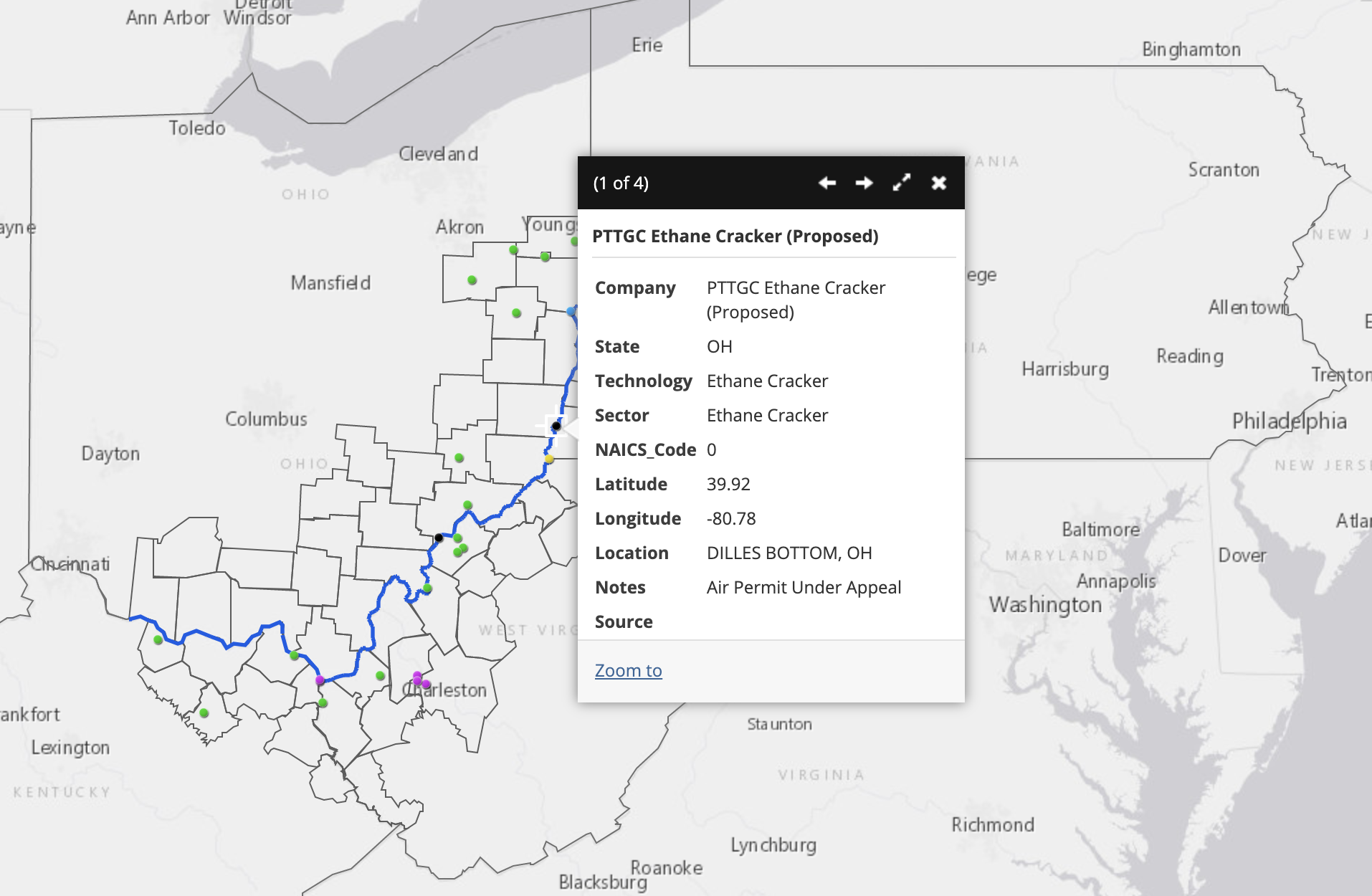
The location of the proposed PTTGC Ethane Cracker in Belmont, Ohio. Go to this map.
There are several fundamental flaws with this plan. One is that the price of plastic is falling. A new report by the Institute for Energy Economics and Financial Analysis (IEEFA) states that the price of plastic today is 40% lower than industry projections in 2010-2013. This is around the time that plans started for a $5.7 billion petrochemical complex in Belmont County, Ohio. This would be the second major infrastructural addition to the planned petrochemical buildout in the Ohio River Valley, the first being the multi-billion dollar ethane cracker plant in Beaver County, Pennsylvania.
Secondly, there is more national and global competition than anticipated, both in supply and production. Natural gas and petrochemical companies have invested in infrastructure in an attempt to take advantage of cheap natural gas, creating an oversupply of plastic, again decreasing prices and revenue. Plus, governments around the world are banning single-use plastics, and McKinsey & Company estimates that up to 60% of plastic production could be based on reuse and recycling by 2050.
Sharp declines in feedstock prices do not lead to rising demand for petrochemical end products.
Third, oil and gas companies were overly optimistic in their projections of national economic growth. The IMF recently projected that GDP growth will slow down in China and the United States in the coming years. And this was before the historic drop in oil prices and the COVID-19 outbreak.
“The risks are becoming insurmountable. The price of plastics is sinking and the market is already oversupplied due to industry overbuilding and increased competition,” said Tom Sanzillo, IEEFA’s director of finance and author of the report.
Oil, gas, and petrochemical companies are facing perilous prospects from demand and supply sides. Increasing supply does not match up with decreasing demand, and as a result the price of oil and plastics are dropping quickly. Tens of thousands of oil and gas workers are being fired, and more than 200 oil and gas companies have filed for bankruptcy in North America in the past five years. Investors are no longer interested in propping up failing companies.
Natural gas accounts for 44% of electricity generation in the United States – more than any other source. Despite that, the cost per megawatt hour of electricity for renewable energy power plants is now cheaper than that of natural gas power plants. At this point, the economy is bound to move towards cleaner and more economically sustainable energy solutions.
It’s not always necessary or appropriate to find a “silver lining” in crises, and it’s wrong to celebrate reduced pollution or renewable energy achievements that come as the direct result of illness and death. Everyone’s first priority must be their health and the health of their community. Yet the pandemic has exposed fundamental flaws in our energy system, and given elected leaders a moment to pause and consider how we should move forward.
It is a pivotal moment in terms of global energy production. With determination, the United States can exercise the political willpower to prioritize people over profits– in this case, public health over fossil fuel companies.
Top photo of petrochemical activity in the Houston, Texas area. By Ted Auch, FracTracker Alliance. Aerial assistance provided by LightHawk.
https://www.fractracker.org/a5ej20sjfwe/wp-content/uploads/2020/04/HoustonArea_feature.jpg6661500Shannon Smithhttps://www.fractracker.org/a5ej20sjfwe/wp-content/uploads/2025/09/2025-Wordmark-Logo.pngShannon Smith2020-03-24 15:48:412021-04-15 14:16:51COVID-19 and the oil & gas industry
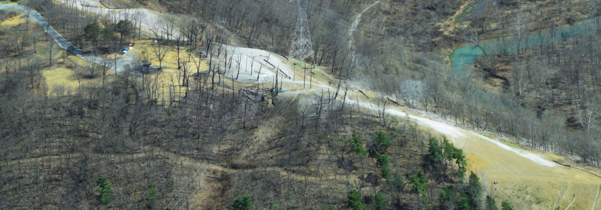
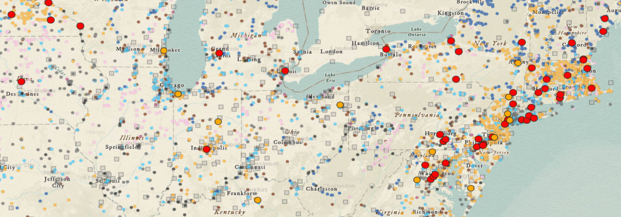
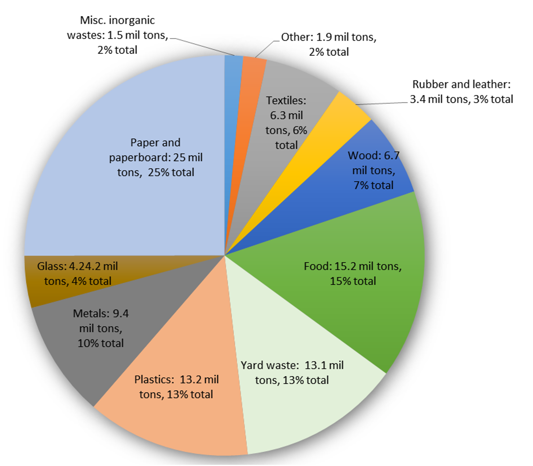
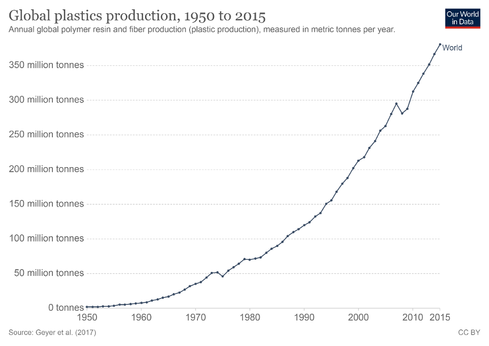
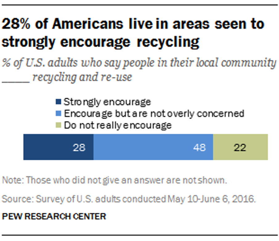
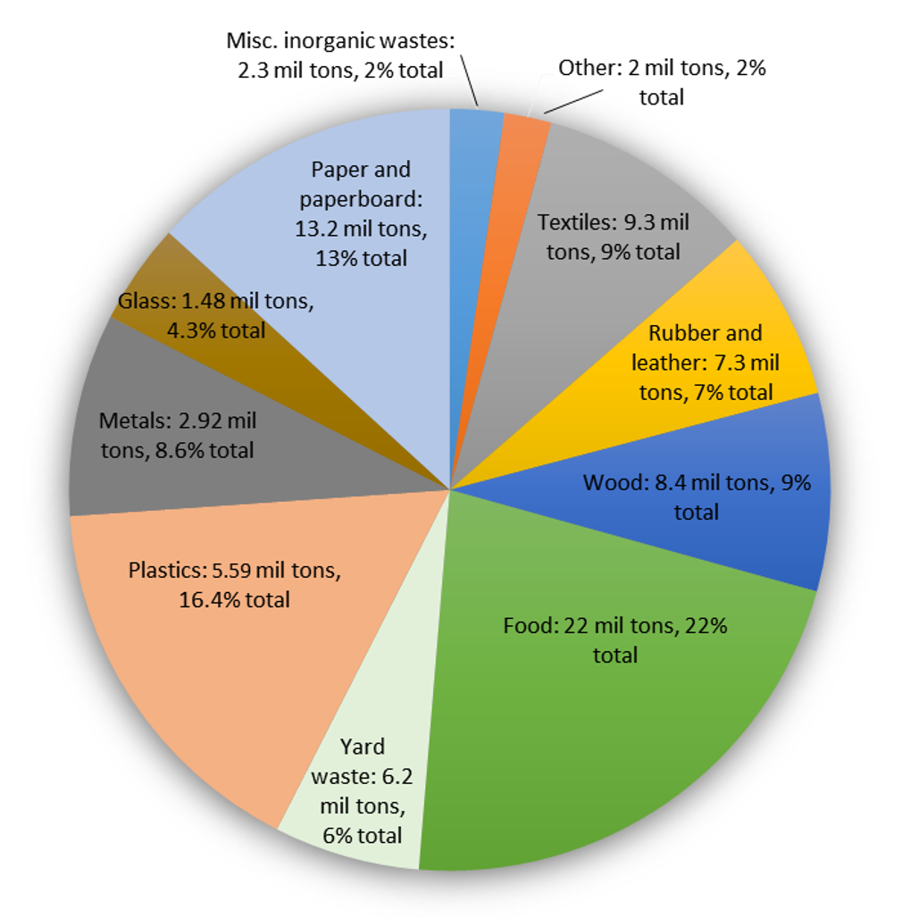
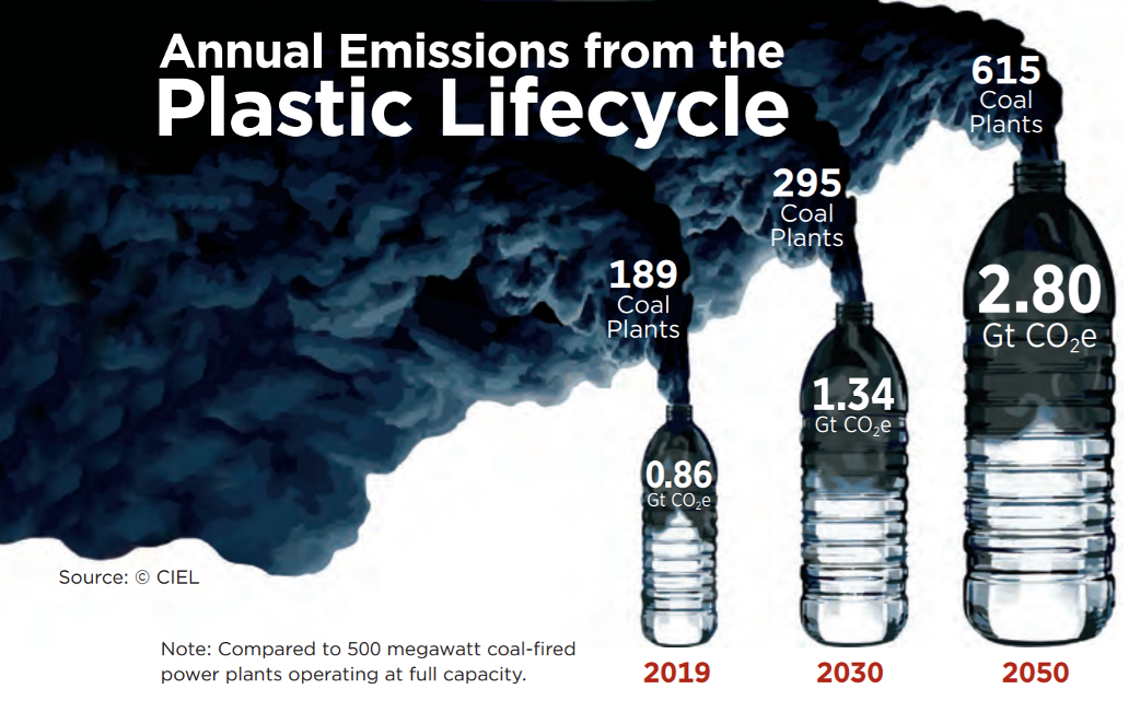


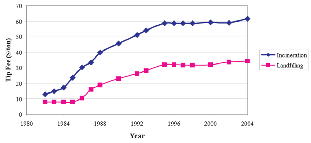
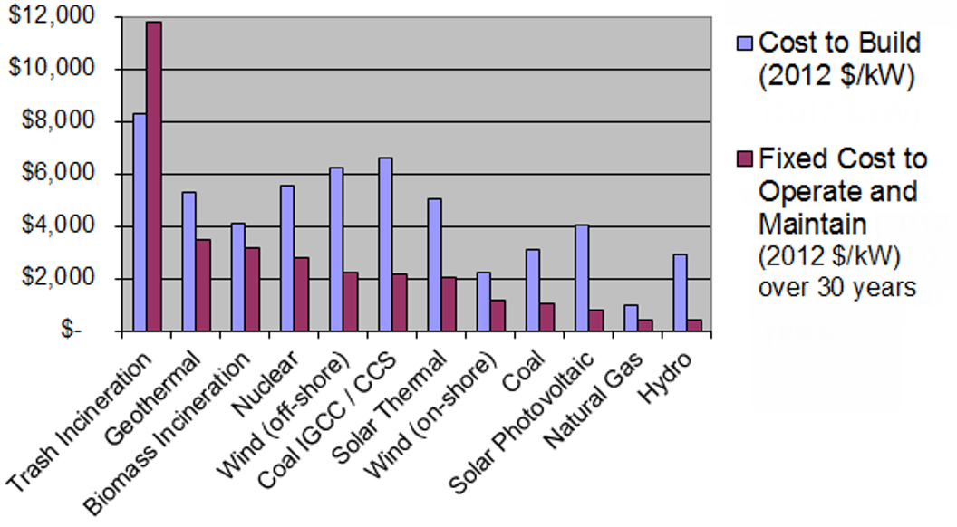
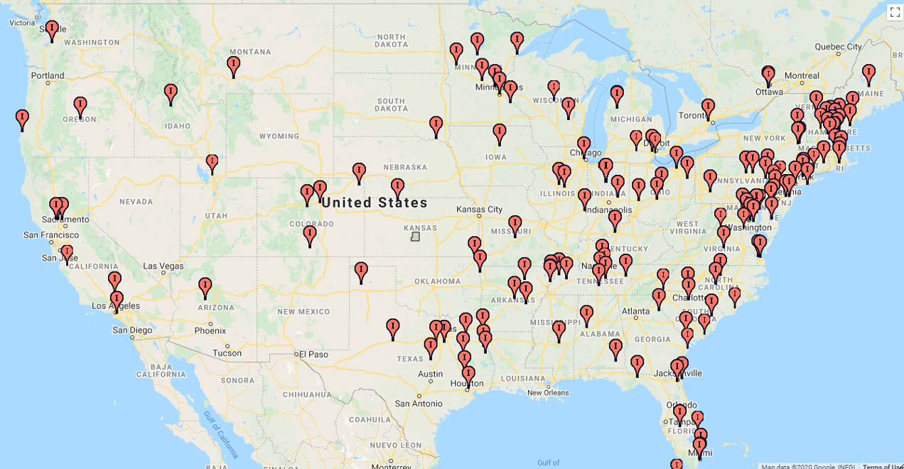
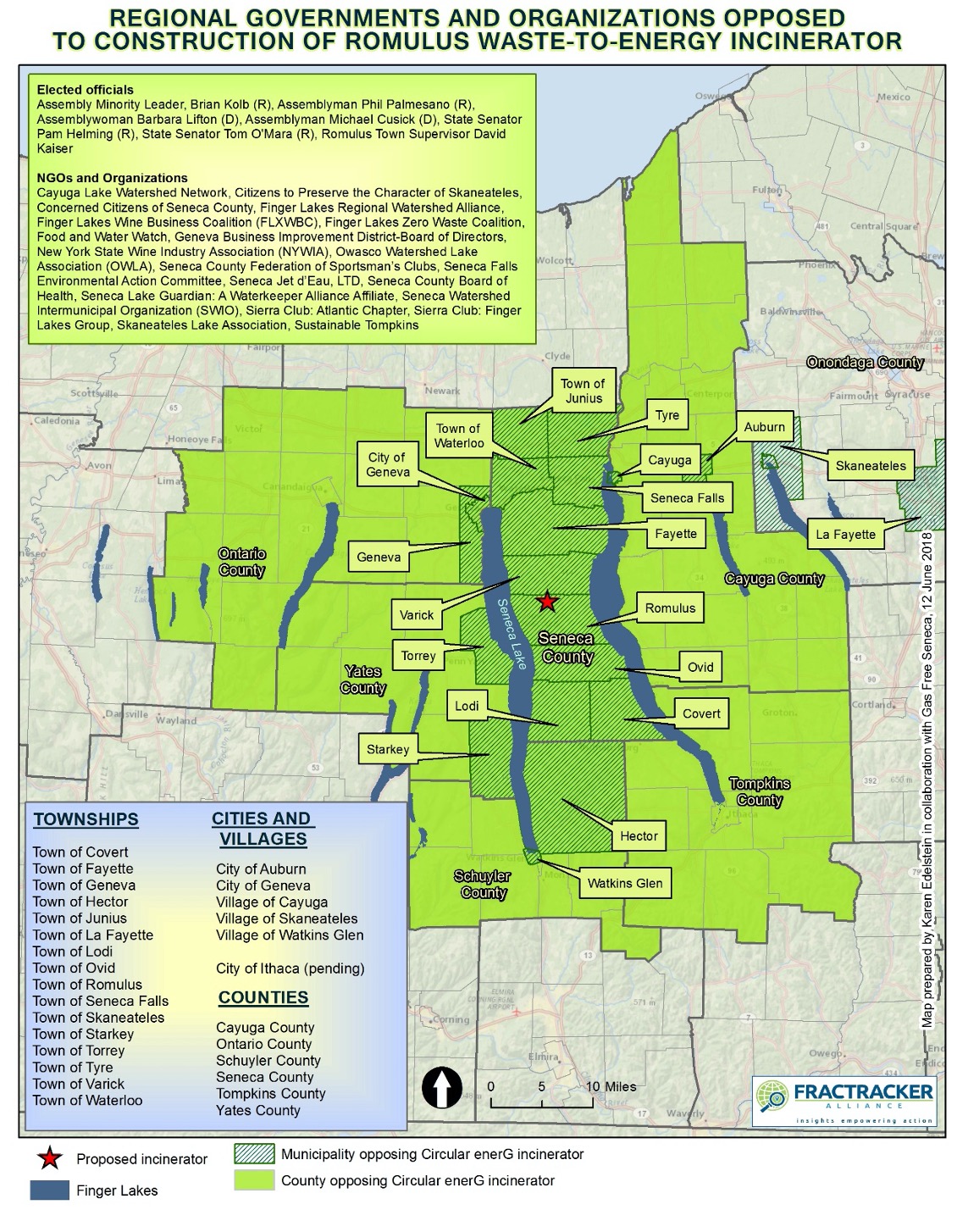
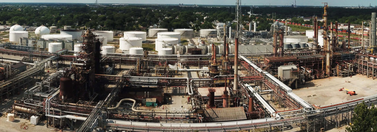

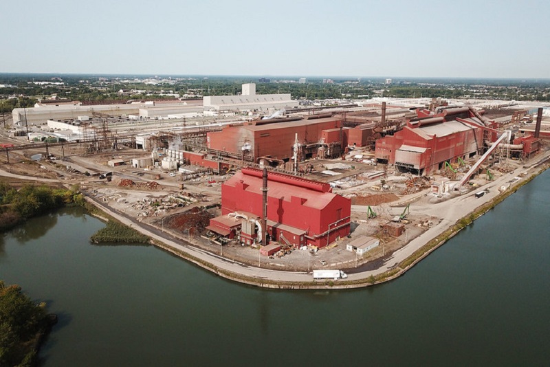
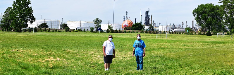
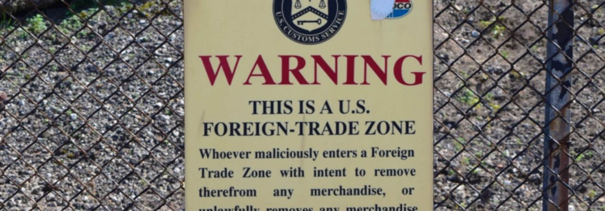
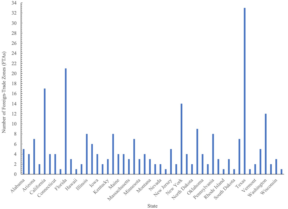
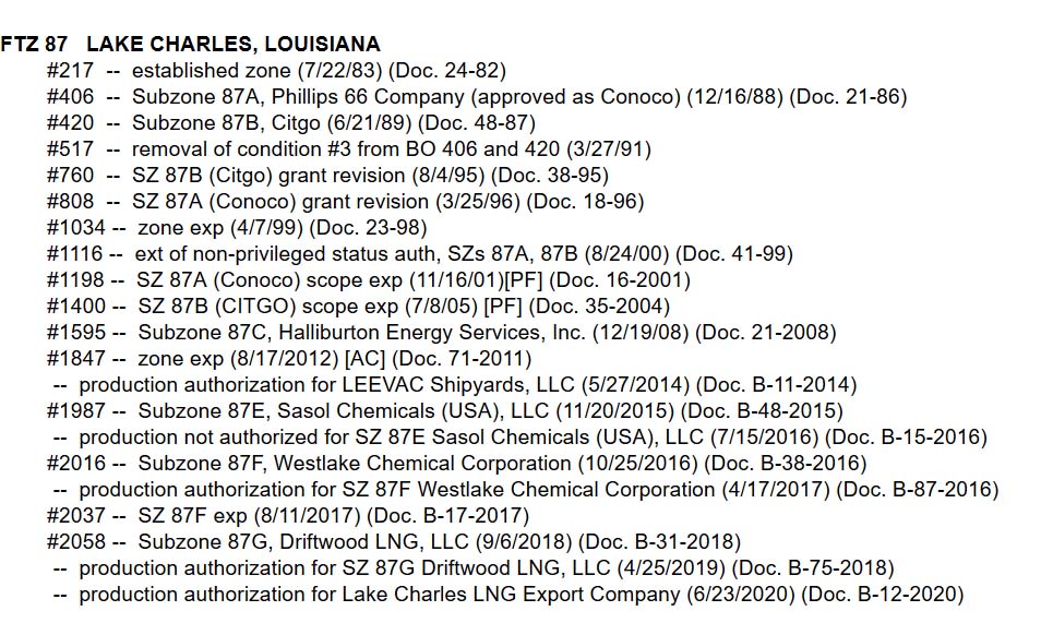
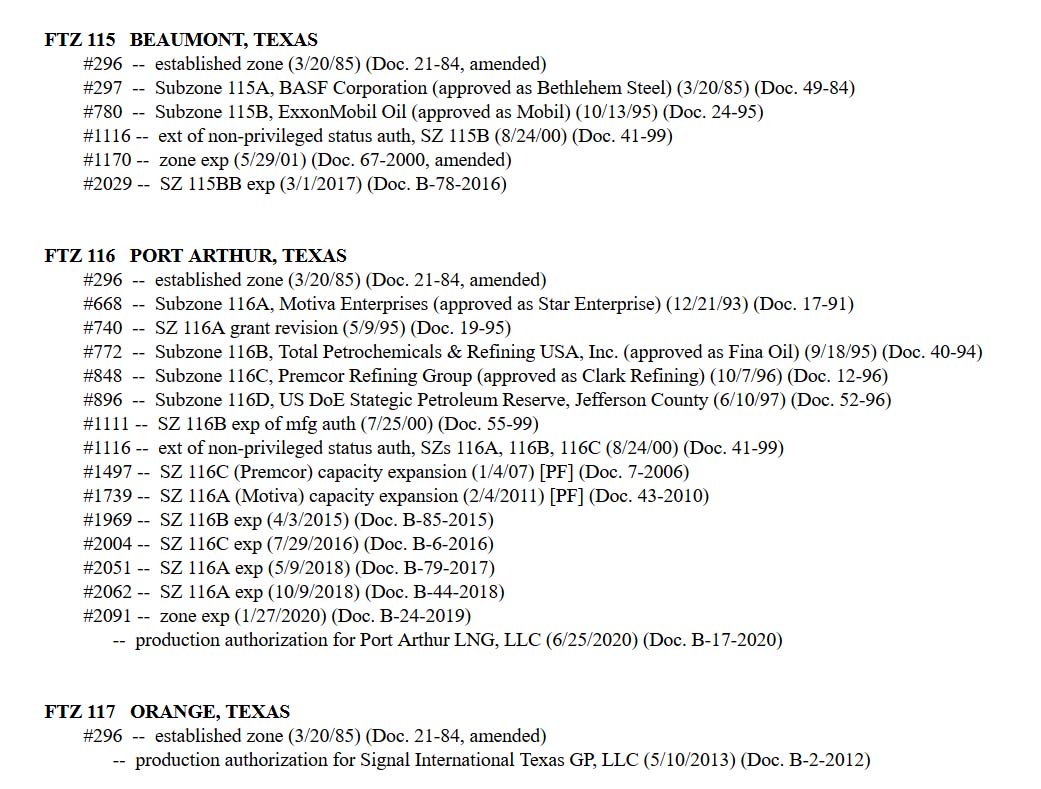
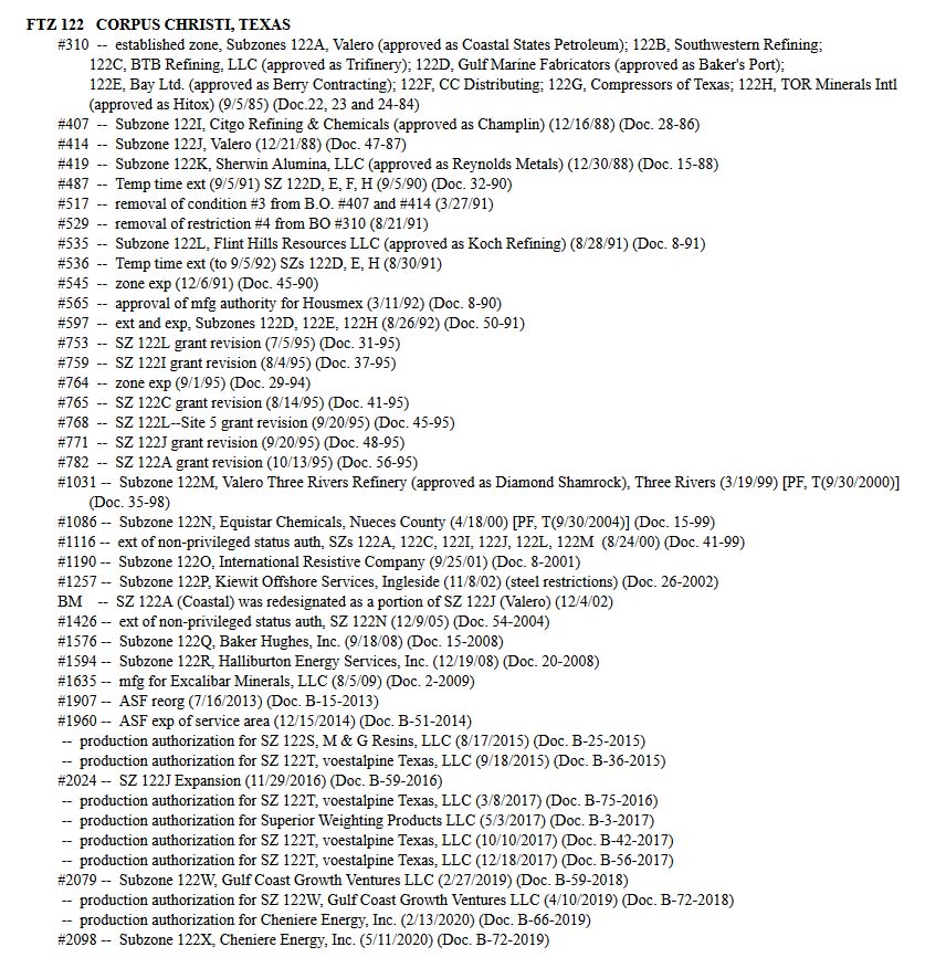
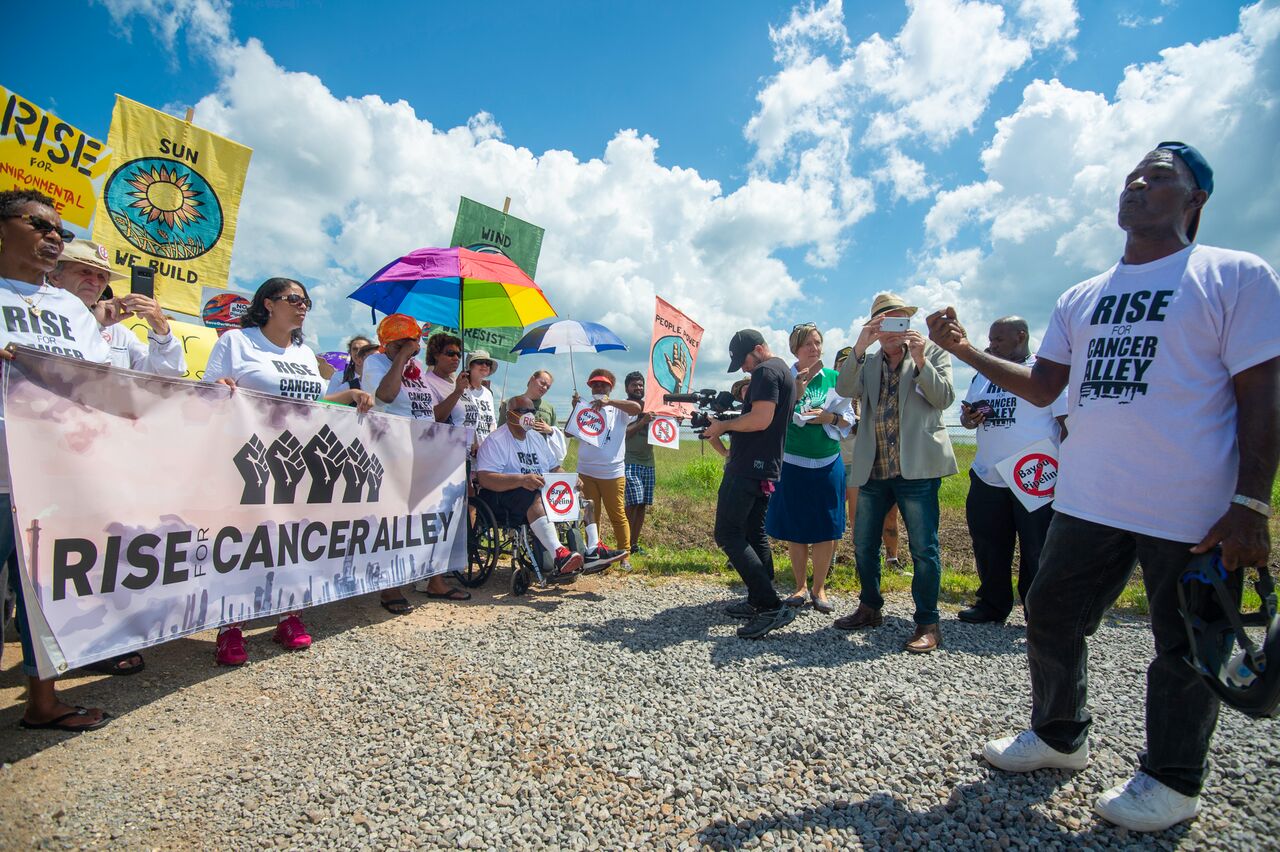
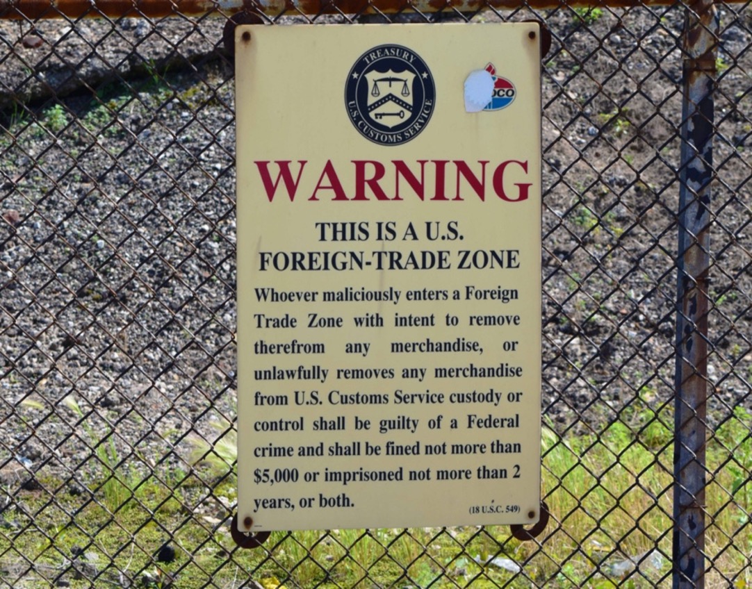

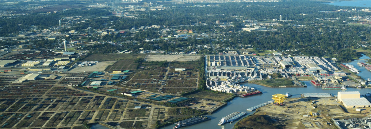 Photo by Ted Auch, FracTracker Alliance, with aerial support by LightHawk